Engravings of the year 1640


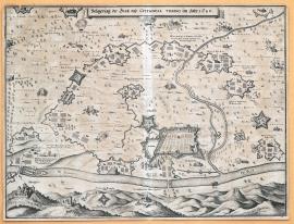
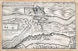
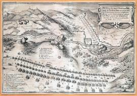
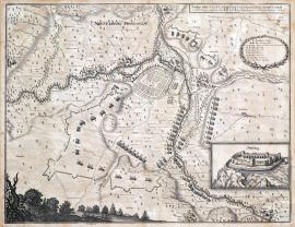
The siege of the town and citadel in Turin in 1640.
The print depicts a detailed plan of the territory around Turin with the river Po spanned by two bridges. A hilly countryside with the Moncaglieri castle is in the foreground. A wide strip of Spanish trenches circles the town; military formations are lined-up in various places in the surroundings. There is a short descriptive German text is on an unrolled ribbon banner.
A ground-plan of the city of Cologne, which was conquered by force of the Imperial army in the month of February 1640.
The print shows a ground-plan of Cologne with its suburbs. The city centre is only sketched. At the bottom flows the river Elbe spanned by a bridge, which connects the city to its quarter Zálabí, with a quadrant medieval tower, the so-called Prachárna (Gunpowder) Tower. The Imperial army is moving closer to the city. The above-stated text is on an unrolled ribbon banner above the picture. There is also the caption A-L.
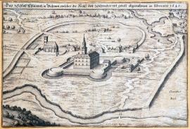
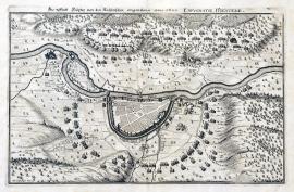
The Chateau of Chlumec in Bohemia, which was taken away from the Swedish by force in February 1640.
The heavily fortified Chlumec Chateau is depicted in the centre of the engraving. (It is the original old chateau not the present-day ‚Karlova Koruna Chateau‘.) Nearby is a small church and there is a large lake on the other side of the chateau (possibly the so-called Žehuňský Lake). The above-stated text is above the picture.
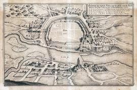
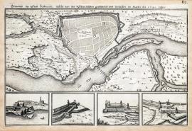
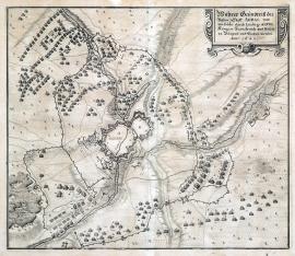
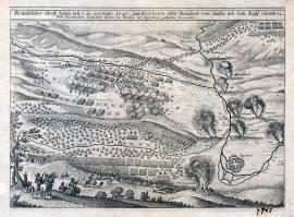
A genuine ground-plan of the town of Hradec Králové in Bohemia including the Swedish fortifications, which was conquered by the army of His Holy Emperor by force, on 20 February 1640.
The engraving maps out the situation of the fortress with an extensive system of water canals. Few villages situated around the town are burning. There is an orienteering compass at the top. Special squares show the following: 2 details of fortification constructions, details of the St Anthony and St Peter’s Gate. The above-stated text is in the centre of the picture.
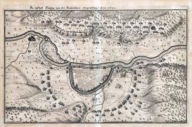
The Chateau of Brandýs in Bohemia, with a fortified Swedish field, which the General Baner left shortly before the arrival of the Imperial forces in March 1640.
The Brandýs Chateau is situated near the river Elbe spanned by a bridge. A stylish maintained garden is depicted around the chateau. The ruins of the town of Staré Boleslav, fortification constructions and the river Jizera are in the foreground. A cross-section of a fortification construction is placed in the small square banner at the far left of the print. The caption A-E is lower down. The inscription stated word-for-word on the previous page is on an unrolled ribbon banner above the picture.
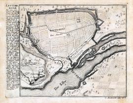
A ground-plan of the town of Litoměřice, which was pillaged and deserted by the Swedish in March of the year 1640.
This copper engraving is divided into two parts; a schematically sketched plan of Litoměřice with fortifications is at the top, while the river Elbe is at the bottom. There are four details of various parts of the town and technical cross-sections of fortification constructions in the other part of the picture.
Litoměřice
This is a small schematically sketched plan of the town of Litoměřice with its nearest surroundings. The river Elbe flows on the right. There is an extensive German text describing the town in the way of a chronicle on the left side.
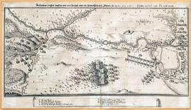
The battle that happened between those of Breda and the Swedish near Plauen in April of the year 1640. The Battle of Plauen.
The print depicts the panorama of the landscape around the town of Plauen in the West Saxony; the river Elster flows through here. Plauen is depicted on the right side of the picture, but its centre is only schematically sketched. A various phases of the fights between the Swedish and the Imperial cavalry led by von Bredau are shown in the terrain around the town. The German explanatory text is placed below the picture; the caption A-H is placed in an ornamental rectangular banner.
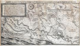
A depiction of two powerful field camps of the army of Holy Roman Empire on one side and the army of the United Crowns and territories on the other, including the position of the same landscape near Saalfeld, and how far one was one army pushed to retreat by the other. May 1640.
The picture outlines the position of two strong armies near Saalfeld, which lies on the right side of the print above the river Saale flowing across the entire length of the picture. The regular formation of the Swedish-French regiments is at the bottom, while the Imperial Army is fortified at the top. The landscape is very meticulously drawn with the attention to detail, there are many minor scenes: for instance a burning village, military guards etc. There is an ornamental cartouche with the German text from the previous sheet at the top right. The caption A-E and F-K is at the bottom left and right.
A true ground-plan of the fortified town of Arras, which was besieged and conquered by the King of France and Navarre Louis XIII. Year 1640.
This print is made to resemble a map with the town and fortress Arras above Scarpa in its centre. The centre of the town is only schematically sketched, while the huge fortifications around the town are painted to detail. The French fortifications and trenches are built in a large circle around the town. The numerous various military regiments randomly pained in the near and far surroundings are noteworthy. There is a square ornamental vignette with the explanatory text at the top right. The map is engraved precisely and delicately, showing a skilled hand of an experienced and artistically mature engraver.
The town of Höxter seized by the Imperial army in 1640.
The Weser river flows across the picture. The town of Höxter is above it in the centre. Its centre is only schematically sketched. Military regiments are standing in a large curve below the town. There are more regiments atop the hills above the river, which are cannonading the area of the town. The image is very delicately done. The landscape is dotted with many big trees. A short explanatory inscription is placed above the picture.
The town of Höxter (was) captured by the Imperial army in 1640.
This print depicts the area along the Weser river with the fortified fortress of Höxter. The centre of the town is left unfinished. Several military troops are placed in the surroundings of the town, hilly and forested landscape scenery is in the background.
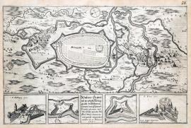
A sketch of the town of Neustadt in Franconia, including the fortifications and encampments of the Imperial and Bavarian armies, on 6 July 1640.
This is a detailed map of the area along the river Saale with the town of Neustadt, which is only schematically sketched. There are various fortification constructions and positions of military formations in the surroundings. The explanatory German text is at the top, the caption A-I is placed in a Lauer wreath. A ruin of Salzburg, situated opposite Neustadt near the Neuhaus Spa, is drawn in a separated square banner at the bottom right. Neustadt lies approx. 80 km northwest of Bamberg.
An original depiction of the Imperial and Bavarian field encampment near Fritzlar, and how the allied army arrived in August 1640.
It is a very delicately engraved plan of the town Fritzlar with extensive surroundings. As usually, the town itself is only schematically sketched. Since the engravers were mostly interested in depiction of the military topics, which they perceived as the purpose of their work, they intentionally neglected other topics, such as the landscape scenery, urban architecture etc. The river Eder flows across the engraving, with Fritzlar above it. At the top left is a banner with the caption A-V. Next to it is an orienteering compass. There are two long lines of army formations on the other side. The German explanatory text is above the picture image.
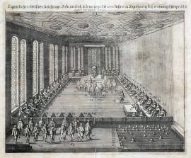
An original depiction of the ceremonial session of the Imperial Diet held on 15 September 1640 in Regensburg, during the opening session eight proposals were brought out and dealt with.
The picture shows the session of the Imperial Diet in a large hall with coffered ceiling. Ferdinand III is on the throne surrounded by numerous court dignitaries. Each person is marked by a number, however the caption below the painting is unfortunately missing. The German text cited word-for-word is place above the picture part of the print.
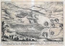
An original sketch of the fight near Ziegenhein, between the Colonel and Director Reinold of Rosa and the Baron of Bredov, on 15 November 1640.
The print depicts a minor battle. Military formations are lined-up behind a forest, while the town of Ziegenhein is sketched on the right. Several cavalrymen are running away in the background, a bugler and three dragoons are depicted in the left foreground. A couple of villages with marked names in the surroundings are burning. The explanatory German text is below the picture.
An accurate drawing of the battle that took place on 15 November 1640 between the Colonel Reinhold of Rosen and the Imperial General Field Marshal Colonel Baron of Breda at Ziegenhein.
The print depicts a minor battle. Military formations are lined-up behind a forest, while the town of Ziegenhein is sketched on the right. Several cavalrymen are running away in the background, a bugler and three dragoons are depicted in the left foreground. A couple of villages with their names marked in the surroundings are burning. The explanatory German text is below the picture.