Engravings of the year 1647


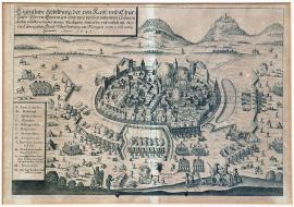
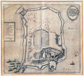
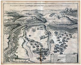
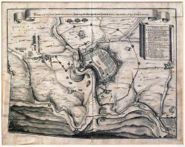
An original depiction of the town of Weissenburg in Norgau, which was surrounded and cannonaded by the Imperial and Electorate-Bavarian armies commanded by their generals and finally handed over upon agreement, from 3 to 23 January 1647.
This engraving depicts a fortified town surrounded by the besieging army firing from many artillery batteries. There are two cavalrymen, three infantrymen and a small dog in the right foreground. At the top left is a square banner with the above-mentioned inscription. The caption A-N is below the picture.
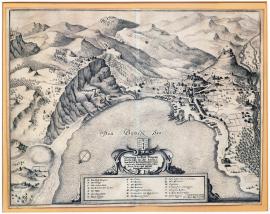
A depiction of the town of Bregenz, which was conquered by an attack of His Excellency the Field Marshal Carl Gustav Wrangel on 5 January 1647.
There is Lake Constance in the bottom part of the depicted landscape, surrounded by mountainous terrain with the town of Bregenz and its chateau atop a high hill. Charging army troops are situated in various places on the hilltops in the countryside near the town. In the bottom centre is an ornamental cartouche with the above-mentioned German explanatory text and the caption A-X. Above the described cartouche is the coat-of-arms of Bregenz.
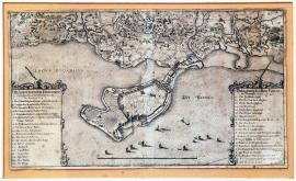
The siege of the town of Lindau on Lake Constance in 1647.
A peninsula cutting into Constance Lake is visible in the top part of the engraving. Lindau lies on this peninsula. The mainland is drawn with much attention to detail. There are few small boats on the lake. The brief German-Latin text and the captions 1-27 and A-N are on rectangular banners supported by two heads of eagles. The eagles are holding the sword and the spectre in their beaks.
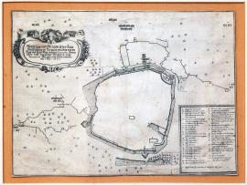
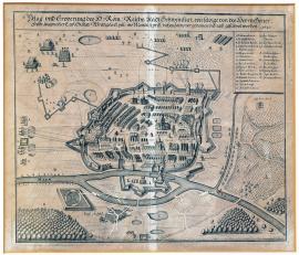
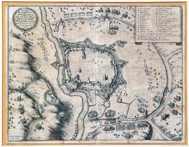
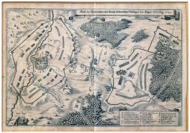
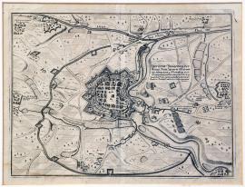
A depiction and a ground-plan of the town of Weissenburg in Norgau, which was besieged and conquered by the Imperial and Electorate-Bavarian (armies) under the Field Commanded Lieutenant General (Feldzeugmeister) of Fernemont on 1 February 1647.
This engraving depicts the plan of the town of Weissenburg and its near surroundings in great detail. The author left out the details of the town centre paying attention only to the bulwark and various fortification constructions that surrounded the town. There are small troops of soldiers and trees in various places in the countryside around the town. There is a richly adorned cartouche on the top left with the above-mentioned German explanatory text. The caption A-Z and 1-13 is in the rectangular banner at the bottom right.
A depiction of the island and fortress of Mainau, which was conquered by His Excellency Field Marshal Carl Gustav Wrangel on 3 February 1647.
This engraving shows the island in Lake Constance with the Mainau fortress under the Swedish attack. The depicted fight is unusually capturing. The conquerors first sailed to the island and then attacked the fortress. There is an oval banner wrapped in the Lauer wreath with the brief German explanatory text describing the depicted event. The caption A-L is placed on the opposite side.
The siege and conquest of the Holy Roman Empire town of Schweinfurt and how this (conquest) was carried out by His Excellency the Field Corps Commander Carl Gustav Wrangel in the month of April of this year 1647.
This is the so-called bird’s eye view of the well-fortified town of Schweinfurt. There are only a few besieging Swedish units in the surroundings. The river Maiz flows in the foreground and there are deep forests in both bottom corners. An orienteering compass is placed on the left. The factual and topographical caption 1-19 and A-F is at the top right. The above word-for-word cited German explanatory text is placed above the picture.
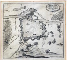
An outline of the town of Schweinfurt, as it was conquered upon agreement by His Excellency Field Marshal Carl Gustav Wrangel on 15 April 1647.
This is a schematic outline of the town of Schweinfurt with only the main buildings and fortification walls done in detail. The river Maiz flows behind the town. There is an island with a stronghold connected to the land by a bridge. Artilleries and sections of deep broadleaved forest are in various places around the town. The German explanatory text is in a banner, wrapped by the Lauer wreath, at the top right.
The Spanish siege of the town of Armentières in Flanders in the presence of His Highness Count Archduke Leopold Wilhelm; it was forced to give up on 20 May 1647.
The town of Armentières is in the centre of the print, which was engraved to resemble a map. The attacking Spanish and Imperial troops are in the near surroundings of the town. The river Lys zigzags across the entire depicted landscape. The above-mentioned German explanatory text is on a ribbon banner at the top right. Below it is an Eagle with the emblem of the Knights of the Cross. It is the coat-of-arms of Leopold Wilhelm, who was the Grand Master of the Order (the Knights of the Teutonic Order). The caption A-Y is in a rectangular banner on the left.
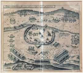
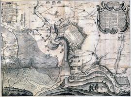
An original ground-plan of the town of Cheb, which was besieged on 14 June by His Excellency the Field Marshal Carl Gustav Wrangel and conquered upon agreement on 5 July 1647.
The town of Cheb situated on the right bank of the river Eger is very nicely drawn, however only the important buildings, churches and fortification constructions are depicted. Army troops, artillery batteries and encampments are in various places around the town. The above-mentioned German explanatory text is in the top left corner in the Lauer wreath. The caption A-CC is on the right.
The siege and conquest of the town of Cheb, from 10 (20) June till 7 (17) July 1647.
The town is schematically outlined with only the most important buildings and fortification constructions done in detail. The river Eger is outlined as a narrow belt. There are the Swedish troop positions in the surroundings. Several hills are in the background, with the gallous atop one of them. The main Swedish tent is on the bottom left. The coat-of-arms of Cheb is at the top left.
An original depiction of two field encampments of the Imperial and Swedish armies near Cheb in July 1647.
This engraving depicts the landscape around Cheb with the river Eger flowing across. The town is only schematically outlined in a relatively small scale. The encampments of the two enemies are on both sides of the town. The brief German explanatory text is in the Laurel wreath in the top left corner. The caption A-V and 1-10 is at the top right.
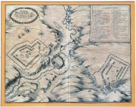
An outline of the Imperial and Swedish field encampments situated between the towns of Planá and Třebel in Bohemia on 9 August 1647.
This engraving depicts the landscape around the towns Planá near Tachov. There are two large field encampments, the Imperial and the Swedish. Various places in the landscape are dotted with strongholds, army troops and guards, individual soldiers and cavalrymen, field camps etc. There are two ribbon banners above and below the map with the brief German explanatory text and the caption A-C and D-N.
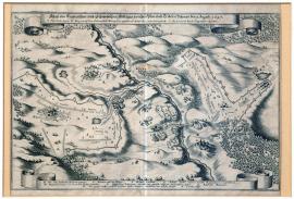
The fight that took place on 12 August 1647 between the Imperial and Royal-Swedish armies near Třebel in Bohemia.
This picture depicts a battle which is greatly spread around the hilly terrain, cut by several zigzagging streams. The method of drawing of the forests, as large groups of trees with round treetops, is typical for this period. The Třebel castle near Planá is at the top right. The above-mentioned German explanatory text is placed in the sky, the caption A-N is on a ribbon banner at the bottom right.
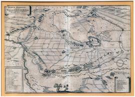
An outline of the Imperial and Royal-Swedish field encampment near Teplá on 30 August 1647.
The small town of Teplá is depicted on the left side of the print. Its monastery is a little lower in the corner. A wide belt of fortification constructions circles the town. The Swedish encampment is on the right side of the engraving near a forest. There are many detailed drawings; for instance patrols, firing cannons, groups of several cavalrymen etc. The river Teplá is outlined on the right side of the print. The brief German explanatory text is on an ornamental ribbon banner in the top right corner and the caption A-Q is on a similar banner on the bottom left.
The siege of Memmingen in 1647. The siege of the Imperial city of Memmingen from 9 September to 14 November 1647.
This is a very detailed and delicately engraved picture. The town of Memmingen is in the right half of the picture surrounded by various fortifications drawn with the unusual attention to detail. Only churches and important buildings are visible in the town centre, the rest of the area is unfilled. The river Iller flows on the left. The lines of conquerors are in a large circle around the town, below is sketched the stream of the small river Büxach. Army troops, individual soldiers and cavalrymen are dotted in various places of the countryside. The above-mentioned inscription is in the ornamental ribbon banner at the top left. The military caption 1-18 is at the bottom of the same side in a rectangular banner. There is an unrolled vignette with the topographical caption A-L is in the right bottom corner. The author of this etching is unknown.
The town of Jihlava was occupied by the enemy on 12 March 1645. However, it was now reconquered by the Field Commanded Lieutenant General (Feldzeugmeister) Count of Puchheim on 2 December 1647.
This large engraving depicts the town of Jihlava and its surroundings at the time of its siege by the Imperial army. The town itself is only schematically outlined; while the fortification constructions and various military scenes are done with a remarkable attention to detail. There is a large baroque cartouche in the top right corner with an extensive caption 1-29. Opposite is a rectangular banner with further caption A-O. There is a minor scene with three officers in the right foreground.
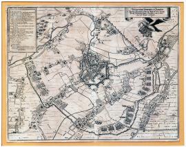
An outline of the siege of the royal city of Jihlava in Moravia, which was finally reconquered and handed upon agreement by the Imperial General Field Gunner John Kristofer the Count of Puchheim after four months of siege on 7 December 1647.
The town of Jihlava lies in the centre of the print. It is drawn in great detail including the fortification constructions. The town is surrounded by enemy’s trenches. The area around the town is divided into squares with depicted army troops, encampments, fortifications and groups of cavalry and infantry. The village of Jezuvice with the main tent of the General Field Gunner (i.e. the artillery general) Puchheim is at the top left. The rivers Malá Jihlava and Velká Jihlava are very distinctively outlined in the landscape very distinctively. The above-mentioned text is placed directly in the picture part of the engraving.
The siege of the town of Jihlava by the Field Commander Lieutenant General (Feldzeugmeister) the Count of Puchheim, which was conquered on 7 December 1647.
This is a well-arranged plan of Jihlava and its surroundings with various fortification constructions, trenches and bulwarks. This engraving is very similar to the engraving No. 385/299 (pgs. 307 and 308). There is an ornamental ribbon banner above the picture with the brief above-mentioned German explanatory text. The caption A-O is placed on a similar slightly wider vignette.