Engravings of the year 1646


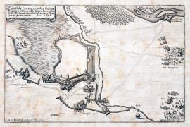
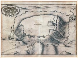
An original sketch of the fortress of Rain, which was besieged and conquered by His Excellency the Field Marshal Carl Gustav Wrangel in 1646.
This engraving shows prominent white areas. The town of Rain is – as it is common on these engravings – only sketched, while the fortification walls, bulwark and towers are done in great detail. The French and Swedish access trenches and other fortification constructions of the attackers are near the town. At the right edge of the engraving is an inscription ‘Schwed. Hauptquartier’. There is a short section of the river Lech in the top right corner. The brief explanatory text is in the ornamental ribbon banner above the picture.
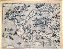
The siege of Ortebelli with the naval battle between the Spanish and the French. In 1646.
The engraving depicts the port of the town of Ortebelli situated on the coast of the Mediterranean Sea directly opposite Corsica. There are many fighting battle ships on the sea. Several firing positions of the artillery batteries are on the mainland, firing at the combating fleets. There is a line of six windmills behind the city and an extensive fortification system, army camps and even fighting infantry units. The above brief word-for-word cited Latin text is in an ornamental ribbon banner at the top left. Another similar banner shows the caption A-G.
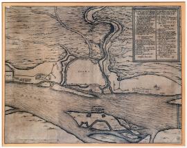
A ground-plan of the siege of the town of Krems by the Lieutenant General (Feldzeugmeister) Count of Puchheim, which was conquered upon agreement on 6 May 1646.
At the bottom of the picture flows the wide river Danube with an island and the town of Krems on its bank. The town is only sketched; its centre is left unfilled. The surrounding countryside is hilly with a zigzagging stream called,Kremswasser’. There is a relatively large square banner with the caption 1-25 and the above-mentioned German explanatory text in the top right corner.
The town of Krems conquered again by the Imperial army in the spring of 1646.
The river Danube with an island flows at the top edge of the copper engraving. The town of Krems is on its left bank. The outline of the town with fortification constructions are done in detail while the centre of the town is unfilled. Near the town is the Krems stream. Artillery batteries firing at the town are situated in the near surroundings of the town. There are ballistic trajectories including the hits or effects of the projectiles on the target drawn meticulously.
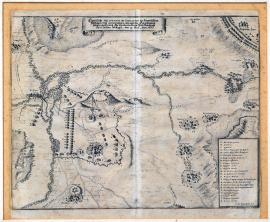
An original drawing of the freeing of the city of Augsburg by his Highness Count Leopold Wilhelm the Archduke of Austria and the commanding Generalissimo of the Holy Roman Empire on 13 October 1646.
This engraving depicts a ground-plan of Augsburg with bulwark and the Swedish attacking constructions. The position of the Imperial-Bavarian army is in the south. There is a burning town of Freiberg to the east above the river Bar. The Swedish-French army is at the top right surrounded by several burning villages. There is a square ornamental cartouche with the German explanatory text and the caption A-Z at the bottom right. There is an orienteering compass at the bottom.
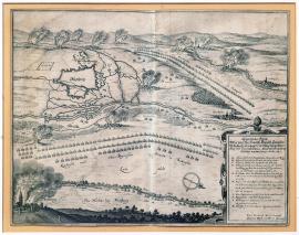
An original drawing of the situation of the Swedish field encampment near Amöneburg as well as the conquest of this place by his Excellency the Field Marshal Carl Gustav Wrangel on 19 June 1646.
This delicate engraving depicts in much detail the situation around the town of Amöneburg in Hesse. The town atop a hill is only schematically sketched. There are many villages and settlements marked by their names in the surroundings and also several army camps and lined-up troops. The Imperial encampment is at the top right of the print. The German explanatory text is on an unrolled ornamental ribbon banner the top. The caption A-Z is in a rectangular banner at the bottom left.
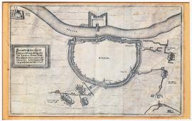
A ground-plan of the town of Höxter, which was defeated and conquered by His Excellency the Field Marshal Carl Gustav Wrangel in the year 1645.
This is a schematic drawing of the town of Höxter. The outline of the town and the fortifications are done in a great detail while the centre of the town is unfilled. The Swedish attacking fortifications and trenches are around the town in a wide circle. The river Weser is at the top with fortifications on its other bank. Nearby to the left is the Corvey Monastery. There is also a square banner on this side of the picture with the above-mentioned inscription.
An original ground-plan of the town of Padeborn, which was conquered by His Excellency the Field Marshal Carl Gustav Wrangel in 1646.
This letter-sized picture shows a schematic ground-plan of the town of Paderborn in Westphalia. Only the fortification walls and towers are done in detail. There are four Swedish firing batteries outside the town. There is a small church drawn at the very bottom. Next to it is a square banner with the above-mentioned German explanatory text. There is an interesting well in the centre of the town, which gave the town its name,Paderborn’ (born = spring).
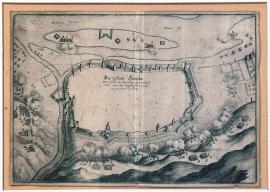
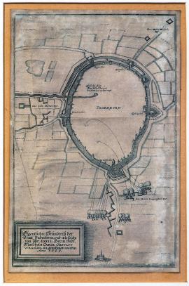
A true geometrical ground-plan of the town of Stattebergen in Westphalia, which was cannonaded and conquered by His Excellency the Field Marshal Carl Gustav Wrangel in 1646.
The town is schematically outlined atop a hill with a river flowing around it. Only a church and several fortification constructions are drawn in detail inside the town. There is a small unnamed village nearby. The Swedish artillery and mortar batteries are firing from four firing positions at the town. There is an oval banner lined with a Lauer wreath with the above-mentioned inscription in the top left corner.