Engravings of the year 1645


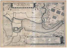
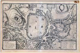
A ground-plan of the town of Rensburg including its siege in 1645.
There is an inscription,Die Eyder Fluss’ on the right side and,Die Bawer See’ on the left side of the engraving. The town of Rensburg is in the centre, surrounded by trenches and fortifications. An inscription,Des Feindes Läger’ is on the top right and the caption A-CC on the bottom right. The brief above-mentioned text is placed in an ornamental square banner also on the left side of the engraving.
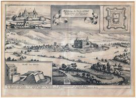
A depiction of the fortified Chateau of Helderungen, as it looked during its destruction in the year of 1645.
The picture shows the Helderungen Chateau situated on a plain with some hills in the background and the river Unstrut spanned by a bridge in the foreground. A banner on the left top shows the look of the chateau before the siege. Opposite to it is the ground-plan of the chateau. The brief explanatory inscription is in an ornamental ribbon in the centre. There is a cross-section of a fortification construction on the bottom left. The caption A-G is aside.
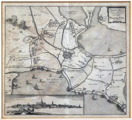
The siege of the town and fortress of Hulst in 1645.
The picture depicts the Hulst fortress surrounded on two sides by water surface. There are various boats sailing on the water. A clash of cavalries is shown at the top left. At the bottom left is an elongated unusual view of Hulst; there are cannons firing from the fortress. The brief inscription, cited word-for-word above, is placed in the top right corner.
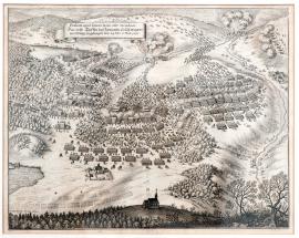
The first clash near Jankov, which took place in the morning and before noon on 24 February and 6 March 1645.
This picture depicts the beginning of the Battle of Jankov. The above-mentioned inscription is placed on an unrolled ribbon banner at the top left. Large fights and the escape of the Imperial army are depicted in the centre. Several villages in the surroundings are on fire. There is a small chapel in the foreground. It is possibly the chapel, which Götz was supposed to occupy with his troop in order to conquer a strategically important hill. However, Götz lost his way and failed to carry out this task. Allegedly this was the reason for the Imperial army being completely defeated in the battle.
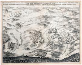
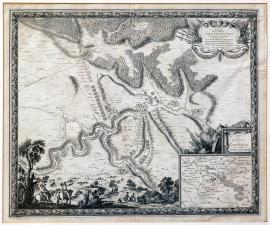
The position of the place near Jankov in Bohemia, where the battle between the Imperial-Roman, Electorate-Bavarian and Electorate-Saxon on one side and the Royal-Swedish army on the other side took place on 24 February of the old calendar and on 6 March of the new calendar in 1645.
The engraving depicts a large hilly countryside around the town of Jankov near Votice. Jankov is depicted on the left side of the picture. There is a forest and a church atop a hill in the foreground. Four villages are burning, there are firing artilleries in several places. At the top left near a village marked by the letter,L’ is a battle line-up of the Swedish army. The Latin-German explanatory text is placed above the picture.
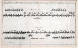
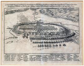
The battle position of the Imperial and Swedish main armies that faced each other near Jankov in Bohemia on 24 February and 6 March 1645.
The engraving depicts schematically the position of the Imperial-Bavarian and Swedish armies. It was typical for the battle plans of the Thirty Years’ War to place the infantry in the centre of the battle formation, with the cavalry squadrons lined-up along both flanks of the army. However, the Swedish army added divisions of forty musketeers amongst the cavalry formations. This tactics was introduced by King Gustav II Adolph and first used in the Battle of Breitenfeld (near Leipzig, 7 September 1631). The cavalry always suffered a lack of firing force, which changed by adding of the musketeers units. Thus the cavalry could rely on the firing support when it was under attack. On the other hand, persistent fire of the musketeers disturbed the enemy’s lines before the attack allowing the cavalry charging with a bigger force. Unfortunately, this engraving does not depict the position of the artillery. The Swedish army introduced some innovation here as well. The cannons no longer stood in one formation during the entire battle. Gustav Adolph II introduced lighter regimental cannons, which were placed into each infantry formation. It was the placement of these lighter cannons, which helped to a large extent to the Swedish victory near Jankov. The Swedish army valued their tactical innovations and was able to fully employ them in battles, such as the Battle of Breitenfeld in 1631 or the Battle of Jankov in 1645.
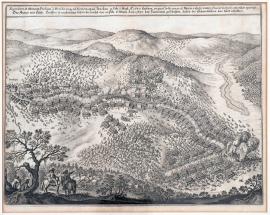
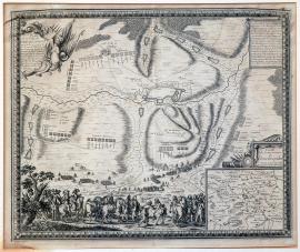
The second and last battle fought from the midday up to the night that took place near Jankov on 24 February 6 March 1645, where the Imperial-Bavarian army was defeated and the Swedish walked out as winners.
The picture shows a mountainous and rather deeply forested countryside separated by several small water streams. At the far left is the town of Jankov. A minor scene with two cavalrymen is in the left foreground. One of them is pointing out with his right hand. The battle is taking place on a relatively large area; the Imperial army is clearly withdrawing. There is an engaging scene in the centre of the picture. Two cavalrymen marked by names,Graff von Hatzfeld’ and,Herr Feldmarschall Dorstensohn’ are shaking their hands. We cannot rule out that the author intended to depict the circumstances of Hatzfeld’s capture, although in reality it happened in quite a different way. The Latin explanatory text is placed above the picture.
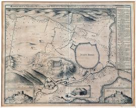
A true outline of the Swedish siege of the city of Brno with the Špilberk Chateau from 24 April till 13 August 1645.
This is a map of the surroundings of Brno; the city itself is only schematically sketched without any details. The Špilberk hill with the chateau is at the edge of the city. There are fortification constructions and trenches of the conquerors in various places around the town. The German explanatory text is above the picture; the caption A-X is on the right in a rectangular banner. There are two detailed views of Špilberk in both bottom corners. There is a detailed drawing of the enemy’s trenches between them.
Brno
This engraving shows a view of the city of Brno. There are churches drawn in the city, nearby are its suburbs and several tiny unnamed rivers. On the left is the Špilberk hill. There is an inscription,Brinn’ is on an ornamental ribbon banner on the far left. Along both sides of the picture are ornamental vignettes with captions A-L and M-5.
A plan of the city of Rottenburg on the river Tauber in Franconia, which was besieged and conquered by the armies of the very Christian King Louis XIV under the command of the Duke d’Engien, supported by the army of the Land Countess Hesenská commanded by the General Geisz on 12 July 1645.
This large engraving of the French origin depicts the city of Rottenburg on the river Tauber and its surroundings. Lined-up army formations are sketched in the depicted landscape. There are deep forests behind the town. There is a scene with two cavalrymen in the left foreground. One of them is pointing ahead with his cord. An ornamental cartouche with allegoric emblems and the above-mentioned French explanatory text are at the top left. A separated banner with a detailed map of the surroundings of Rottenburg is at the bottom right. Above that are more emblems of a military character. The entire print is framed in a decorative engraved frame.
An original depiction of the very bloody battle between the Royal-French and Electorate-Bavarian armies, in which the French army got the field (i.e. won); this took place between Nördlingen and Donauwörth on 24 July of the year 1645.
This is a picture of a battle that is usually called the,Battle of Allerheim’. There is the formation of the Bavarian army atop a hill in the centre of the painting. Its right flank is withdrawing and starting to flee. The river Wörnitz flows around the said hill. Bellow the hill to the right is the French position. A path leading to Nördlingen is sketched nearby. The German explanatory text is above the picture and the extensive caption 1-42, A-Z and 1-7 is below the picture.
A plan of the town of Dinkelsbühl in Swabia, which was besieged by the armies of the very Christin King Louis XIV with the support of the army of the land Countess Hessenská, commanded by the Duke d’Enghein, the general of the armies of his Majesty in Germany, on 19 August 1645 and brought to obedience again on 26 of the same month.
The town of Dinkelsbühl situated in Swabia is depicted in the centre of this large map. It is surrounded by forests, several ponds and streams. The army troops and fortification constructions are dotted in various places of the countryside. A minor scene depicting the meeting of the Duke d’Enghein (the so-called Condé) with the General de Grammont is depicted in the foreground. On the right is a small map of Swabia with an appropriate inscription and a scale. There is a banner in the top right corner with a description of the depicted event. The above-mentioned French text is in an ornamental cartouche on the other side.