Engravings of the year 1638


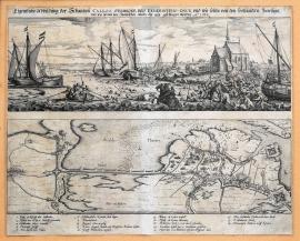
An original depiction of the bulwark in Caloo, Verbroek and Feuerschen, which were fortified by the Dutch, who were ousted out from here again by Spanish. Year 1638.
The copper engraving consists of two fully separated views placed above each other. The upper picture depicts a battle on the opposite bank of the river Scheldt. There is a church on the right, several sailboats on the river and many drowning soldiers in the water. The bottom picture is done to resemble a map of the situation around the mouth of the Scheldt; there are some fortification constructions and a lot of fighting regiments. The caption 1-18 is below the pictures.
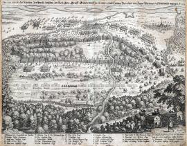
The fierce fight of the Imperial, Electorate-Bavarian and Weimar armies on Sunday 28 / 18 as well as Wednesday 21 of this and 3 March of the year 1638 in and near Rheinfelden.
This engraving is much alike the record No 227/29 D, pg. 185. However in the foreground is depicted the battle itself instead of the army formations and camps that are on the above-stated record. It can be presumed that both prints are either the work by one person, or that the print from the year 1634 was used as a model for the depiction of the fight of Rheinfelden in 1638.
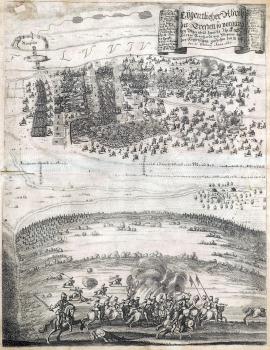
A real depiction of the fight that took place near Rheinfelden between His Highness Price Duke Bernhard of Weimar and the Imperial army from 18 / 28 February until 21 February of 1638.
The picture is divided into two parts across the middle. The wide stream of the Rhine with the town of Reinfelden on its other side flows at the top. Nearby a battle is raving, in which the Imperial army was finally defeated on 21 March 1638 thanks to the tactical art and ploy carried out by Bernhard of Weimar. The German explanatory text is placed on a wide unrolled ribbon banner at the top right and together with the caption 1-11 and A-N. The bottom half of the picture depicts the first battle on 18 February, which was won by the Imperial army.
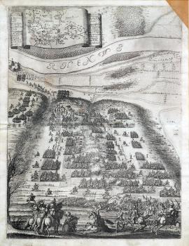
The Battle of Rheinfelden
The usual explanatory inscription is missing on this copper engraving. However, according to the depicted event and the topographical and factual caption, this is undoubtedly the Battle of Rheinfelden, on 18 – 12 February 1638. This tall picture is divided by the river Rhine across the middle. A battle is raving near the river; there are three buglers and a group of Croatians at the foreground. There is a map of the Upper Rhineland on the wide unrolled ribbon banner at the top. The captions A-O and a-i are on both sides.
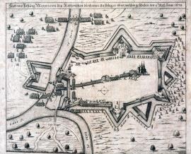
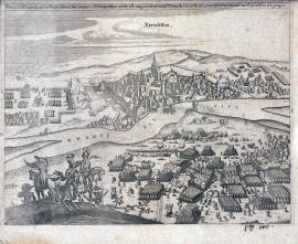
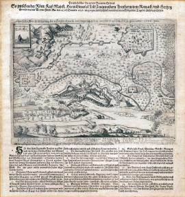
The town and fortress of Meppen is being conquered by an unexpected strike of the Imperial forces, on 1 / 11 May 1638.
The fortified town of Meppen is in the centre of the engraving, however represented only by a large church. Four lines of army troops are marching into the centre of the town. Cannon batteries are firing in two places. The confluence of the rivers Ems and Hase is near the town; soldiers are wading the water. Individual cavalry and infantry soldiers are attacking the town. There are large trees in the countryside.
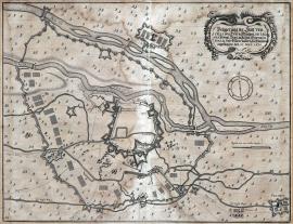
The siege of the town of Vercelli, which was initiated on 27 May 1638 by the Margrave de Leganes, the General in Italy and the Governor of Milano of his Royal Highness in Spain.
The picture of Milano and its surrounding is done to resemble a map. The landscape is dotted with trees, the rivers Sesia and Seruio flow across the picture. The small town of Pelarol is at the bottom right. It is surrounded by army constructions and camps. There is an ornamental cartouche in the right top corner with the stated German text. An orienteering compass is drawn below it.
An original depiction of the main pass and the outstanding fortress of Brysach, which was surrounded by walls and fortification by His Grace the Duke Bernhard of Saxon, besieged from 6 August till 2 December 1638 and finally forced to give up.
This map shows the river Rhine which streams out into many branches near Brysach. The town and the fortress are painted on the left bank of the river. There are various strongholds, fortifications, military camps etc. in the surrounding countryside. Banners with the topographical and factual caption A-Z and 1-16 are at the top left and right. A profile of the fortification system is shown on a special banner. Above it is an orienteering compass. The German explanatory text, cited word-for-word above is placed above the picture. According to Drugulin, the picture is the work by Th. Kluge, an artillery colonel.
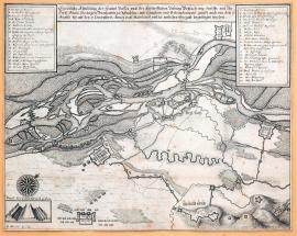
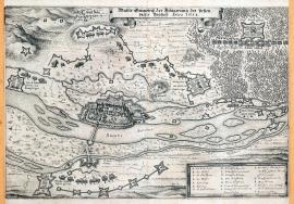
A depiction of the fierce fight between the Imperial General Count Götz, the Duke de Savelli and the Duke Bernhard Saxon-Weimar that took place near Wittenweyer. Year 1638.
The river Rhine flows at the top border of the engraving. The small village of Wittenweyer is below right. A visible path goes down the middle of the picture; it turns into a dam further down. There is a thick forest in the foreground with the Swedish horse-pulled carriages and several infantry soldiers. The battle is depicted in the centre of the engraving – the Imperial army is already retreating. The topographical and factual legend A-S and 1-15 is at the bottom.
An original ground-plan of the siege of the fortified pass of Brysach including the retreat that took place on 9 / 19 December 1638.
The print depicts the siege of Brysach with the river Rhine spanned by two bridges flowing below. There are many trees in the landscape. Three buglers are in the left foreground. A cross-section of the fortification is placed in a special banner at the top left. The caption A-N and the above-stated German text are below the picture. There is also a long text divided into fourteen articles, including the conditions of capitulation and handover of the town by the General Reinach to the Duke Bernhard Saxon-Weimar.
A genuine ground-plan of the siege of fortified pass of Brysach. Year 1638.
This is a plan of the area around Brysach. The river Rhine with several islands flows through the landscape. The town itself with the fortress is done in a very charming way and with great precision. Enemy’s army formations and fortifications are in the surroundings. A large forest with the formation of the General Götz’s army is at the top right. An oblong banner with the caption A-T is at the bottom right.