Engravings of the year 1637


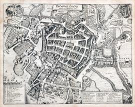
The city of Leipzig under the siege of 1637.
This is a very meticulous bird’s eye view of the city. There is the streamed out river Pleisa and a number of gardens outside the city. Several Swedish regiments are attacking the city, mainly from the south. There are two coats-of-arms at the top, one of them is Saxon. The above-stated German text is on an unrolled ribbon banner above the picture. Two rectangular banners with captions A-O, P-Z and 1-14 are at the bottom left and right.
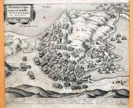
A ground-plan of the siege and battle outside Leucate in Languedoc, year 1637.
A hilly peninsula in the Mediterranean Sea near Leucat Lake is depicted on the picture. A battle between the French and Spanish is raging on the peninsula. A ship is sailing on the sea. Leucate is situated at the seaside near Perpignan. The stated German text is placed in a rectangular cartouche at the top left. The local and factual caption is below the picture.
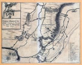
A genuine ground-plan of the town of Corbie in Pikartie with the siege of 1637.
The picture depicts the rivers Ancre and Somme. On a hillock above the Somme is the fortress of Corbie, surrounded by an extensive system of fortifications. There are several army camps in the surrounding countryside. There is a cross-section detail of the fortification at the top right above the stated German test. The topographical and factual caption A-D and 1-20 is placed at the bottom right.
A genuine ground-plan of the town of Dolle in Burgundy and its siege, commenced on 1 June 1637.
The town of Dolle (Dole on the river Doubs) approx. 50 km southeast of Dijon in France lies in the centre of the engraving. The so-called bird’s eye view is done merely schematically, however the fortifications around the town are drawn quite meticulously. The river Le Doux (Doubs) spanned by a bridge leading out of the town flows across the bottom part of the picture. There are numerous fortification constructions, army line-ups and camps around the town. There is a wide circle of trenches around the town. The background is hilly. A detail of the fortification with the enemy’s trenches is in the top left corner in a square. The caption 1-22 and A–K is at the right in a rectangular banner. There is an orienteering compass at the bottom left.
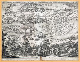
A true ground-plan of the Swedish bulwark and the bridge of ships near Rheinau, conquered by the Imperial forces in 1637.
This copper engraving depicts a section of the upper stream of the Rhine that spills out in a forested terrain. The formation of regiments near the burning township of Wittenweyer is in the background. The Imperial soldiers are attacking the Swedish fortifications. In the foreground are some minor scenes with cavalrymen escorting the captives. The above-stated German test is above the picture, while the caption A-M is below it. Drugulin believes this engraving to be the work by M. Merian.
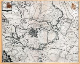
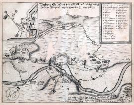
The siege of the town of Bredy by the Duke Frederick Henry of Orange on 23 July 1637.
This is a map of the town of Bredy and its wide surroundings done with a great attention to detail. The fortifications of the conquerors circle the town widely. The stated German text is at the top left, below is an ornamental unrolled ribbon scroll with two coats-of-arms. Army formations as well as individual figures are painted all over the area of the print.