Engravings of the year 1626


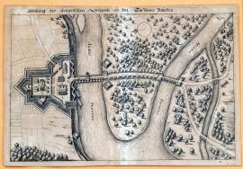
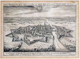
An illustration of the imperial walls near the Dessau bridge
In the middle of the image, the confluence of Mulda and Elbe is illustrated. On the left bank of the Elbe, there is the imperial wall, a bridge behind it and a dam over the peninsula to Mulda, which is crossed by a bridge again. The whole landscape is heavily covered with individual trees. The town of Dessau is pictured on the right side of the print. Troops or camps of the troops are not here. Dessau lies approximately 100 kilometers southwest from Berlin.
Dessau
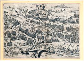
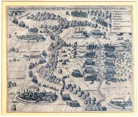
It is a print without a more detailed textual explanation which depicts the defeated Mansfeld by Wallenstein at the Dessau bridge on 15 April 1626. The engraving is done in detail with many realistic particularities. There is a bridge across the river Elbe, fortress, Mansfeld’s chances and explosion of his ammunition supplies. On the right side we can see the town of Zerbst.
The actual illustration of the Mansfeld’s defeat at the Dessau bridge, which happened on 25 April, the day of St. Mark, in 1626.
Heavily forested landscape with the Elbe, into which the river Mulde flows. The battle and fleeing of Mansfeld’s army are displayed on the shore behind the bridge that crosses both rivers. On the left side, there is a compass. Above the image, there is a text, at the bottom, there are the explanatory notes A-Z.
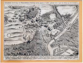
The actual illustration of Münden, which was conquered and seized in 1626 by the Imperial General, Count Tilly.
On the engraving, there is the Tilly’s army shooting across the river Vézère, which is crossed by the bridge to the town of Münden. On the other bank of Vézère, there is an additional units’ attack. The background of the image is a forested, hilly panorama, in the right foreground, there is the gallows and a big wheel.
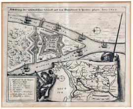
A true depiction of the town of Elbing, which was fortified by His Royal Majesty of Sweden, etc. in 1626.
In wide plateau, with the sea in the background, there is the besieged town of Elbing, from which a high church tower protrudes, and it is surrounded by powerful moats. On the right side, the same river runs through the town. Towards the upper edge of the image, there is the emblem of the town. Elbing is located in East Prussia on the sea coast, approximately half the distance between Kaliningrad and Gdynia. Below the image, there are explanatory notes A-S.
The illustration of the Swedish chances on the River Vistula in Prussia in 1626.
The engraving shows the flow of the River Vistula which divides into two. The bridge crosses the river and there are several sailing ships on the surface. On the furthest tip of the peninsula, which is created by both shoulders of the Vistula, is a Swedish fortress with a cleared forest behind it. In the bottom right corner of the image, there are two private soldiers, one with a pike, the other with a musket, holding a map of the area of Lower Vistula River and the Baltic Sea with a visible compass. There is a square with the explanatory notes 1-10 at the bottom left.
The actual illustration of the great victory, which achieved Count Tilly, the Imperial General, over the King of Denmark on 22 August 1626, according to the new calendar.
The engraving shows the situation of the battle between Tilly and the Christian IV of Denmark near Lutter. There are marked the towns of Wolfenbüttel, Lutter, Northeim, Göttingen and Duderstadt. From Lutter to Duderstadt, there flows a stream, which separates the positions of both armies. In the right corner, there is a rectangle with the explanatory notes A-F.
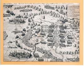
A sketch of the bloody battle in which His Excellency the Count Tilly, Imperial General, fought with the King of Denmark on 22 August 1626.
There are the towns of Göttingen, Northeim, Sese and Wolfenbüttel in the picture. The main location of the image is the battle between the two armies across the stream. There is the Fort Lutter nearby and the town of Duderstadt at the bottom right. In the upper right corner, there are explanatory notes A-G in the square. The quoted text is written in an antique font above the image of the copperplate.
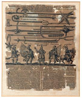
A port of good luck, peasant wars which took place a hundred years ago, with actual pictures and drawings of leading officers and commanders, as well as arms and weapons used by the rebelling peasants in the small country above (the river) Inn taking place in the year 1626 during their presumed war campaign.
Under the above text, many peasant weapons are depicted which were used during the peasant riots in the year 1626 in Upper Austria. It is noteworthy that the depicted weapons also include several Czech Hussite weapons, e.g. „ein böhmischer eiserner Morgenstern“, „ein žiškaischer Streitkolben“ or „ein böhmischer Kornhammer.“ There are even instructions for use for some of the weapons, e.g. the weapons marked A are held by several warriors on long poles; then they run into the groups of enemy horsemen and pull the riders from the horses using large hooks. Under the weapons there are pictures of five peasant chiefs, and one other chief on a horse. The peasant commanders are identified by their names. A two-verse explanation of the picture follows, with anti-peasant tendencies.