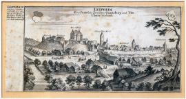
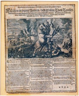
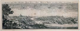
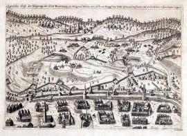
Leipheim, The engraving shows a view of the town of Leipheim with some of the important buildings highlighted. In the foreground to the right, there is a tree with the town coat of arms above. Another arm and a brief description of Leipheim are situated to the left.
Signature: G. Bodener fecit et excudit.
Autor: Bodenehr G., mědirytec a kartograf
Original name: Leipheim ein Stättlein zwischen Güntzburg und Ulm. Ulmer Gebieths.
Katalogová čísla: Collection Český Šternberk, kód: 416/475
Leipheim lies in Württemberg region, which was witnessing a range of war clashes during the Thirty Years' War. The scene depicted in the graphic is not linked directly with any specific war episode. Its dating nevertheless falls roughly to the era of the Thirty Years' War, which is why it forms a part of the Sternberg collection.
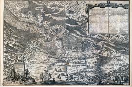
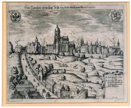
Limburg, The work shows the town with a fortress situated on a steep hill. The Wesdret rivulet is flowing through the landscape surrounding the fortress. Nearby to the right, in vicinity of the river, there is the village of Dolhen. In the left bottom part there is a square field with the inscription “Limburg” and with caption: 1 to 9.
Signature: Not available
Autor: Unknown
Original name: Limburg
Katalogová čísla: Collection Český Šternberk, kód: 417/360
In this case it is difficult to identify the events depicted in the engraving. The only clues consist of the facts that Limburg lies in western Belgium and that the graphic portrays Dutch artillery batteries and infantry. These circumstances could indicate that the depicted scene describes an incident from the protracted war between Spain and Netherlands, the setting of which lied at the mentioned territory around 1630. Frederick Henry, Prince of Orange, led the Estates-General of the United Netherlands of the time. His versatile skills made it possible to bring the country to unprecedented economic, military and social achievements. The terms of peace reached by the Dutch in the peace negotiations in Münster on 15th May 1648 were extremely advantageous.
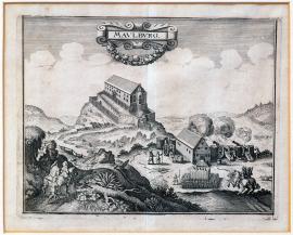
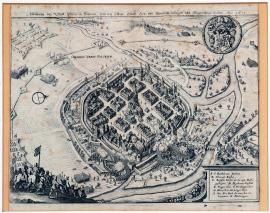
Maulburg, This relatively small engraving depicts an elongate building on a hill under cannonade. Behind the firing position of the cannons there are army troops lined up. In the foreground, on both sides, there are two riders, those to the left with a musketeer. Above the image there is a decorative cartouche with the inscription “Maulburg”.
Signature: Not available
Autor: Unknown
Original name: Maulburg
Katalogová čísla: Collection Český Šternberk, kód: 418/364
Maulburg lies in the southern Baden region, which was witnessing many war incidents around 1630. It is just this circumstance that enables approximate dating of the depicted combat action, however without possibility of further specification.
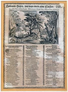
The engraving depicts a romantic forest with huge trees, with a secluded house on the left and with a pond in the foreground. Three scenes (A, B, C) occurring in the forest describe a robbery committed on a travelling priest by a wandering soldier. Below the image there is an extensive three-stanza poem reading a dialogue between the priest and the robbing soldier.
Signature: Not available
Autor: Unknown
Original name: Soldaten Segen, wie man einem ohne Fluchen, Schlägen, ja ohne Mord und Blutvergiessen, mit lauter guten Worten, Pferd, Geld und Kleider abnehmen kann.
Katalogová čísla: Collection Český Šternberk, kód: 419/128
The leaflet deals in a witty and sarcastic way with the issue of the crimes of robbery committed on travellers by deserters, which were widespread during the Thirty Years' War. Taking the entire property from a priest using 'just nice words' instead of violence is apparently meant ironically towards the robbed priest whose faith disapproves any form of violence. It is obvious that the unrestrained demoralization spread especially amongst mercenary armies produced brutality and violence as side effect.
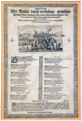
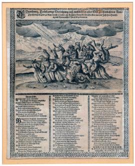
The engraving shows a group of rural people (men, women and children), lamenting the hardships and suffering caused by the war. Some have clasped hands, others lift up their farming tools towards heaven. In the background there is a village with a church, partly in flames and plundered by soldiers. Under the picture there is a 12-stanza German poem pleading for help and protection. Below the poem there are quotations from the Book of Psalms from Old Testament (Psalms 60, 67), and the Book of Lamentations.
Signature: Strassburg bey Jacob von der Heyden.
Autor: Unknown
Original name: Klag und Bettlied der Armen durch vielfaltige grausame schädliche Krieg Durchzüg und andere weg hochbedrängten und beschwerten Bawers und Landleuten in der gantzen Christenheit umb den lieben Frieden. Nach dem alten Kirchengesang: Da pacem Domine in diebus nostris, gerichtet oder verleih und Frieden gnädiglich etc.
Katalogová čísla: Collection Český Šternberk, kód: 420/127
The leaflet is dealing with the subject of suffering and hardship of rural people during the Thirty Years' War due to plundering, which was one of standard fighting methods applied at the enemy territory. This inhumane and cruel practice frequently resulted in depopulation of entire areas.
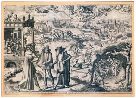
In its bottom right part, the engraving depicts the Pope, a Cardinal, a Jesuit high official (probably Superior General of the Order) and Prince Primates of the Holy Roman Empire gathered in a cave. They are discussing the upcoming anti-Protestant measures. To the left, the Jesuit is getting money from a wealthy nobleman for an anti-Protestant propaganda, nevertheless to no effect. Behind these figures in the house there are: a Jesuit, several released and deserter mercenaries, as well as a range of other villains; the inscription above their heads goes: “Hic Inferis erat in terra Praesidium”, which means: “Here is hell on earth”. In the sky we can see the God wearing a Jesuit biretta and holding the insignia “IHS” with the nails and the pierced heart. In the background, various scenes take place, allegorically representing subversive activity of the Jesuits and the Catholic Church against the Protestants, or so-called Counter-Reformation. There are for instance big fish eating small ones; ships in the sea with the inscriptions warning that the sea is infested with evil sea fish; two beasts of prey chasing a stork with an accompanying explanation that this is an evidence that the piety is being persecuted; two foxes attacking a chick, meaning that the malicious preponderance brutally exterminates the innocent and defenceless; two cats attacking a mouse – a game naturally ending up with the death of the weak mouse, etc. The texts in the engraving are mainly in Dutch. At the top to the right we can see the siege of a town attacked by an army and hit by the bullets and shots of an artillery. A brief explanatory text in German (quoted above) is written below the image.
Signature: Not available
Autor: Unknown
Original name: Jesuitischer Pater überall, und römischer einschleichender Jagdhund, der auf Erden und im Meer, ja auch in der Lufft und im Himmel allenthalben einzuschleichen sich understehet.
Katalogová čísla: Collection Český Šternberk, kód: 421/124
This propagandistic leaflet published by the Protestants criticizes and mocks the intensive Counter-Reformation measures taken by the Catholic Church, the Jesuit Order, the Emperor and the Prince Primates of the Holy Roman Empire. The recatholisation was in particular carried out at the territories conquered during the Thirty Years' War by the imperial troops while having previously belonged to a member of the Protestant military community.
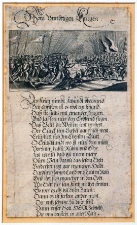
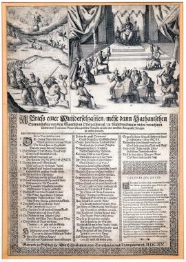
This small engraving illustrates a fight between two armies, shooting one at another. Several dead and wounded bodies lye in the battlefield. The soldiers are armed with lances, with several combat standards discernible amongst them. Under the image there is a German text in verses, depicting the horrors of war, hunger, misery, looting, plundering, general decline of morality, absurdity of the fight between the members of the same nation, which is ultimately benefited from only by the 'hereditary enemy of the Turks'. The poem urges its readers to return to the Lord and virtuous life.
Signature: Not available
Autor: Unknown
Original name: Vom unnöttigen Kriegen.
Katalogová čísla: Collection Český Šternberk, kód: 422/118
The leaflet denounces the uselessness of war with all its terrible side effects. The peace efforts of the mankind 300 years ago were just as current as today, nevertheless similarly ineffective.
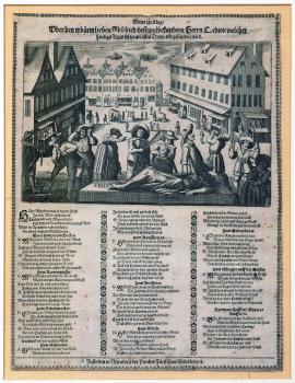
The engraving depicts a town square with a few shops, in front of which there are merchants and various tradesmen, lamenting and wailing. In the middle of the image there is an elevated bed with the dead credit. At the left side of the catafalque a gravedigger is digging a grave for the dead. Under the image there is a three-stanza German poem containing a dialogue between a merchant and his customers with the chorus that keeps repeating that it is impossible to sell goods on credit, as “Herr Credit” is dead.
Signature: Zu finden in Nürnberg bey Paulus Fürst Kunsthändlern, etc.
Autor: Fürst Paulus, nakladatel v Norimberku, obchodník s uměleckými předměty
Original name: Trawrige Klag über den erbärmlichen Abschied desz wohlbekandten Herrn Credits, welcher heutigs Tags schier an allen Orten tod gefunden wird.
Katalogová čísla: Collection Český Šternberk, kód: 423/115
This leaflet wittily portrays the economic situation during the Thirty Years' War, perceivable especially in the stagnation of trade.
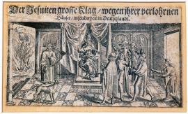
In a room with two entrances the Roman Pope is sitting on his throne. He is wearing a tiara and holding a triple-barred cross in his right hand; his left hand is pointing to the right, where the door opens to the view of a fire in distance (probably representing the hell) with two men being burned therein. The Pope's Throne is decorated with drapery and various curtains. Four Jesuits are coming from the right. Apparently, they are intensively and vividly defending themselves and excusing their failures, gesturing animatedly and lifting their fingers in an oath. At the Pope's left-hand side two Swiss guards are standing with partisans (polearms with a long cutting and stabbing blade). On the opposite side a Cardinal is standing with a big dog nearby. The floor has a mosaic pattern of distinct square tiles.
Signature: Not available
Autor: Unknown
Original name: Der Jesuiten grosse Klag, wegen ihrer verlohrenen Häuser, insonderheit in Deutschland.
Katalogová čísla: Collection Český Šternberk, kód: 424/59
This leaflet issued by the Protestant party mocks the failures sustained by the imperial army and the Catholic Church, in particular by the Jesuits, when several times defeated in Germany around the year 1630. Having represented the most agile part of the Catholic Church, the Jesuits were obviously hated the most by the Protestants and were among the first to be expelled from the territories occupied by the Protestants and to get their properties confiscated there. Just as they were fleeing from Bohemia after the victory of the uprising of the Czech estates in 1618, the Jesuits were once again forced to run away from Germany after the resolute victories of the Swedes at the beginning of the second war decade. This failure of the Catholic Church and the hasty escape of the Jesuits from central Germany naturally provoked hilarity and malicious joy amongst their Protestant opponents, which is expressed both in words and image in the described graphic. The Jesuits who have escaped are apologizing to the Pope for their defeat in Germany and the Pope is threatening them with hell-fire.
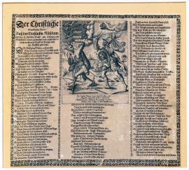
The engraving depicts a man in armour and helmet, holding a sword in his right hand and a shield with the image of Christ in his left hand, fighting with the evil spirit. The shield reads the words “Scutum fidei”, the sword reads “Gladius Dei Verbum spiritus”, the belt reads 'veritas', etc. A hand with a crown “corona gloriam” protrudes from the cloud above the figure of the knight. The devil on the run is called “princeps mundi”; he is holding various tools for game (or souls) trapping in his hand. A swarm of wasps, the bats, winged snakes and lizards called “Potestates Tenebrarum” are flying above the devil's head. The devil has goose legs, carries a quiver with the inscription “Ignea body” and has a vespiary in his anus from where the wasps are flying out to attack the knight. An extensive German text in verse on both sides of the image explains the depicted allegorical scene. A short poem in Latin below briefly summarizes what vices are to be avoided and why a virtuous life should be lived.
Signature: Not available
Autor: Unknown
Original name: Der Christliche streittende Ritter, ausz der geistlichen Rüstkammer des H. Paulus zu Ephesern am sechsten Capitul, gemustert und ausstaffiert, auch im offenen Truck verfertiget und ins Kupfer gebracht.
Katalogová čísla: Collection Český Šternberk, kód: 425/54
This anonymous and undated leaflet, published apparently by the Catholics, sharply attacks wickedness and moral corruption born during the Thirty Years' War. The subject of the graphic is derived from the famous St. Paul's Epistles to the Ephesians, chapter VI: “Therefore take unto you the armour of God, … having your loins girt about with truth,... having on the breastplate of justice, … taking the shield of faith, … the helmet of salvation and the sword of the Spirit...“, etc.
The picture portrays a large creature with a horse's right foot and a human left one protected with an armour. The beast is holding a halberd and a flaming torch in its right hand; the left hand in the shape of a lion's paw is holding various seized objects: chalices, monstrances, chains, etc. Similarly, the mouth in the wolf head is clenching stolen liturgical gear. The monster has a mangy rat tail dragging a tangle of snakes, toads and salamanders. A wounded soldier lies supine in front of the beast. In the background we can see a burning village and its villagers running away while pursued by the army. In the background to the right there is a picture of a town, with the sun rising behind. A group of men carrying various craft tools are walking peacefully through the streets. The above described monster, struck by lightning and killed now, is lying in front of them. From its bowels cut open the stolen items fall out. - Below the image there is a German poem denouncing the horrors of war and urging humble and virtuous life.
Signature: Not available
Autor: Unknown
Original name: Abbildung des unbarmhertzigen, grausam und grewlichen Thiers, welches in wenig Jahren den groszten Theil Teutschlandes erbärm- und jämmerlich verheeret auszgezehret und verderbet. Beneben einem Bericht, woher daszelbe seinen Ursprung, wer solches erzogen, ernehret, etc. Endlich durch was Mittel seiner wieder los zu werden. Männiglich an Tag gegeben.
Katalogová čísla: Collection Český Šternberk, kód: 426/53
This anonymous and undated leaflet depicts both in image and word the horrors of war as opposed to the peaceful and salutary life in peace. It represents an enthusiastic projection of longing for peace, aptly illustrating mentality of the masses of civilians devastated by the Thirty Years' War.
Signature: Not available
Autor: Unknown
Original name:
Signature: Not available
Autor: Unknown
Original name:
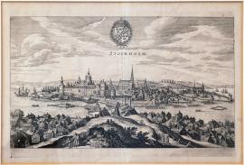
Stockholm, Signature: Not available
Autor: Unknown
Original name: Stockholm
Leipzig, On
06.01.1547 (do 27.01.1547)With its time perspective and topic the engraving does not fall within the collection. In the middle is Leipzig besieged by the armies that are depicted in detail. At the right bottom corner are the gallows, and the picture of God (relatively non-artificial), beneath which are an angel with a laurel wreath and two burning balls, is depicted in the sky. Beneath the upper edge there is a long rectangle containing the above inscription. Beneath the picture, there is legend 1-21 followed by several verses.
Signature: Not available
Autor: Unknown
Original name: Wahrhafftig Abcontra-feyung der Statt Leyptzig, wie die nach Abbrennung der Vorstatt von Churfürst Johann Friedrich zu Sachsen belägert und beschossen worden von 6. bis 27. Jenner im Jahr Christi 1547.
Katalogová čísla: Collection Český Šternberk, kód: 1/469
John Frederick, Elector of Saxony, who was born in 1503 and died in 1554, was an intransigent protestant who soon became involved in disputes with the emperor Charles V. He was one of the main members of the so-called Schmalkaldic League and fought for several years in the Schmalkaldic war against the Emperor and against his close relative the Duke Maurice of Saxony who supported the Emperor. John Frederick re-conquered Saxony that was occupied by Maurice of Saxony. The sequence of these fights also included the stated siege and conquest of Leipzig in 1547. However, in the same year, the protestant armies were defeated by the Emperor close to Mühlberg and John Frederic, Elector of Saxony, was taken captive and deprived of his electoral rank.
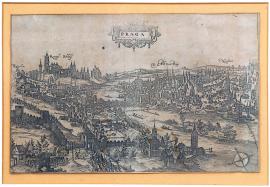
Praha, On
15.02.1611An overall view of Prague from the south without any further time and factual details. The armed forces are campaigning in the direction from Újezd Gate and an attack has unleashed in the Lesser Town Square. The individual Prague towns are marked separately, for example, Retschin, Königl. Schloss, Altstatt, etc. In the sky there is the cartouche inscription ‘Prague’.
Signature: G. Keller
Autor: Unknown
Original name: „Praga“
Katalogová čísla: Collection Český Šternberk, kód: 2/331
It is undoubtedly the Passau armed forces’ invasion of Prague on 15 February 1611. They invaded the Lesser Town through Újezd Gate. The archduke Leopold of Styria wanted to rush to help Rudolf II in conquering the countries delegated by his brother Matthew and in subjugating the Czech estates. The Passau armed forces conquered and plundered the Lesser Town. The Passau soldiers wanted to go on campaigning against the Old Town as well. However, they were prevented from doing so due to the Gate to Charles Bridge being dropped. The remaining soldiers were then killed. The turmoil arisen in the whole of Prague was taken advantage of by the ordinary people who turned their anger against Catholic monasteries where they looted and killed the monks. One of these monasteries was the Franciscan Monastery attached to the Saint Mary of the Snow where fourteen monks became victims of murder. (The after-effects of these events lasted up to nowadays. In the summer 2012, the remains of these monks were reclaimed and, subsequently, the monks were beatified.) In the end, the Passau armed forces were made to leave Prague. However, their unsuccessful invasion had far-reaching consequences and the emperor Rudolph II was made to pass the ruling power onto his brother Matthew.
Pražský hrad, On
21.06.1617The ceremonial act of coronation is depicted in 5 scenes. In the middle is a bigger picture of the coronation in St. Vitus Cathedral. On the left: the king is putting his hand on the Bible and is taking his oath; the king’s unction follows. On the right: the king is receiving the sword, the sceptre and the imperial apple. Over these pictures there is an inscription on the right side of which is a cartouche with the Czech lion, on the left side is the same cartouche with the imperial eagle. In the middle is the portrait of Ferdinand II ringed with a laurel wreath held by two angels.
Signature: Not available
Autor: Unknown
Original name: „Eigentliche Abbildung, wie Kays. Mayt. Ferdinandus secundus den 21. Junii 1617 zum böhmischen König gekrönt worden zu Prag.“
Katalogová čísla: Collection Český Šternberk, kód: 3/208
Ferdinand II was the son of the archduke Charles of Styria born in 1578. After long hesitations, he was appointed Matthew’s substitute since Matthew’s brothers Albrecht and Maxmillian were already relatively old and had no children at that time. However, this candidature awoke certain resistance on the part of the Protestant princes (of Palatinate, Saxony, etc.) who feared radical catholicised interventions promoted by the Styria branch of the Habsburgs’ in its inherited countries (in Carinthia, Styria, Carniola, etc.). When Matthew finally appeared before the Czech Crown estates and recommended that his cousin Ferdinand be his successor, the estates accepted the proposal. Ferdinand swore that as long as Matthew was alive, he would not intervene in the monarchical affairs of the Czech Crown and that after he ascended the throne he would preserve all the privileges of the estates and, in particular, would confirm Rudolph’s majesty of 1609. On 26 June 1617, Ferdinand was enthroned as the Czech king. The estates behaved very politely and even the king made a favourable impression with his willing and amiable behaviour. However, this seeming reconciliation turned into severe disputes that soon afterwards resulted in the Czech uprising.
On
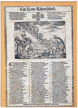
01.01.1618 (do 31.12.1618)The printing depicts an obliquely standing ladder used by the short men to take various coins up. Down by the ladder is the usurer with a treasury and a bag of money, a short way off are a peasant, a craftsman and a burgher lamenting and moaning. In the background of the picture is a hilly countryside. Over the picture is a German poem having two stanzas and requesting an intangible, inanimate item that cannot walk but may go up or down (understand: the value of money). Below is another poem dealing with various misuses of money, speculations, and other financial intrigues and ended by the deliberation that only God may guide the humankind out of these low predatory interests.
Signature: Daniel Mannaser, mědirytec v Augsburgu u Warthabruckerthor
Autor: Manasser Daniel, rytec a nakladatel v Augsburgu
Original name: Eine Newe Rätherschaft
Katalogová čísla: Collection Český Šternberk, kód: 8/75
A leaflet satirically condemning the usury, business speculations and other financial intrigues that were considerably spread in the 17th century, in particular, due to the Thirty Years’ War and the economic breakdown caused by such war.
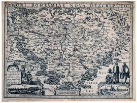
Hradčany, On
01.01.1618 (do 31.12.1618)It is a detailed, but sometimes inaccurately elaborated, map of the Czech countries, furnished with a scale on its edges. At the right bottom corner are depicted Hradčany outside which is a person wearing a coat and holding a string with the tied imperial eagle. Not far away is a person making a bow and taking off his hat. On the other side in a decorative cartouche there is the symbol with the Czech lion held by a faun leaning against the board on which there is the dedication to Eylhar Lubina, professor at the university in Rostock, from the engraver Kaeria.
Signature: P. Kaerius Excudebat Amstalodami. Anno a nato Christo 1618
Autor: Lubinus Eylhar, profesor rostocké university
Original name: Regni Bohemiae nova descriptio.
Katalogová čísla: Collection Český Šternberk, kód: 9/93
This map of Bohemia of the period of renaissance is very interesting, in particular, with its notes stated in various towns, for example: Hec olim Bubenium quondam etiam Marobudu ab conditore dicta; Krumlov, Budějovice and Kutná Hora: Habent argenti fodines; Rakovník: Habent optimam cerevisiam; Klatovy: Praestat opt. caseis; Prachatice: Salis emporium; etc. There is a big forest drawn between Český Šternberk and the Sázava monastery. The Konopiště is called as “Konnepsch”. The importance of the persons described above and holding the symbols cannot be explained.
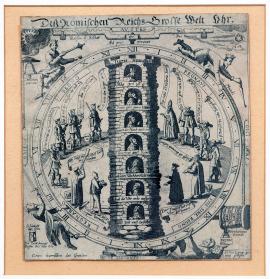
On
01.01.1618 (do 31.12.1618)The picture is the symbol of political changes in the Roman German Empire in the 17th century. In the high tower with seven floors there is the emperor depicted with seven electors. Non-imperial earls are staying aside and are observing the development. The dial-plate of the clock driven by faith depicts four kings going up and down.
Signature: Not available
Autor: Unknown
Original name: Des römischen Reiches grosse Welt Uhr.
Katalogová čísla: Collection Český Šternberk, kód: 10/63
The period of the Thirty Years’ War was typical of frequent political turnarounds. This situation is aptly characterized by the picture. Alongside the year 1618 marked on the right side of the printing, Drugulin is stating the year 1630 that is, however, missing in the sheet. Thus, it is possible to deduce that the author related his satire to a longer time period than only to the year 1618.
Praha, On
01.01.1618 (do 31.12.1628)The view of the entire city of Prague across both banks of the Vltava („Moltav fluvius“) has been drawn very carefully. In the left foreground there is a staffage of trees. Above the picture there is the above-mentioned text. In the sky there are coats of arms: Hradčany, Malá Strana (Little Quarter), Czech, Imperial, Staré Město (Old Town), Nové Město (New Town) and Vyšehrad.
The print is not signed, but the concept is reminiscent of Hollar, or perhaps the graphic art was based on Hollar's template. This engraving is in many ways strikingly similar to Hollar's picture of Prague.
Signature: Not available
Autor: Unknown
Original name: Prospect der weitberühmten Königl. Hauptstadt Prag in Böhmen, wie solche jetziger Zeit anzusehen ist.
Katalogová čísla: Collection Český Šternberk, kód: 113/387
On several occasions, Prague was the setting for events which had a profound, determining influence on the course of the Thirty Years' War. In 1618, the Czech uprising culminated in the defenestration of Prague, in 1620 the Battle of White Mountain was fought, and a year later a bloody execution was carried out on the Old Town Square. The establishment of Waldstein's military and political power has its roots in Prague. 1633 saw the invasion of Prague by the Saxons, and in 1635 there was the so-called Prague truce between the Emperor and John George I. Elector of Saxony. Waldstein's death in 1634 also had an effect on the conditions in Prague. In 1648 Prague was besieged by the Swedes under Königsmark and Count Palatine Carl Gustav of Rhineland.
Příkop pod Pražským hradem, On
23.05.1618It is a picture of Hradčany from the today’s Klárov. On the left side there are the new castle stairs. In the place of the today’s gardens on the slope to the Lesser Town there is a preserve (“Thiergarten”) with the deer. Under B there is the provincial office window from which the emperor’s governors are falling. At the upper corners there are the imperial eagle and the Czech lion in laurel wreaths. At the right bottom corner is legend A-C; there is an explanatory inscription in German over the picture.
Signature: Not available
Autor: Unknown
Original name: Wahre Contrafactur wie die Kays. Räthe zum Fenster hinaus geworffen worden seindt.
Katalogová čísla: Collection Český Šternberk, kód: 4/363
The Prague defenestration was an immediate inducement that triggered the Thirty Years’ War. However, the actual causes of this catastrophe could already be seen in the development of whole decades. On the fateful day of 23 May 1618, representatives of the unsatisfied Czech estates headed by Henry Matthew, the earl Thurn-Valsassina, Colonna von Fels, Pavel of Říčany and others crowded together and moved towards the castle, requiring entry to the provincial office where the emperor’s counsels Jan Bořita of Martinice, Vilém Slavata of Chlum and Košumberk, Děpold of Lobkowicz and Adam of Sternberg were having a meeting. There the rebels presented their requirements resolutely and provocatively. By his calm and conciliatory answer, the highest burgrave Adam of Sternberg tried to face the danger, but a severe exchange of opinions flared up and resulted in Lobkowicz and Sternberg being dragged to the adjacent room and Slavata and Martinic being grasped and thrown out of the window. Their faith was also shared by the scribe Fabricius who found himself in the castle ditch. Except for bruises and contusion, nobody was seriously injured. The same day Fabricius left for Vienna and informed the emperor about the events taking place in Prague. For his merits, he was awarded noble status and received the predicate “of Hohenfall”.
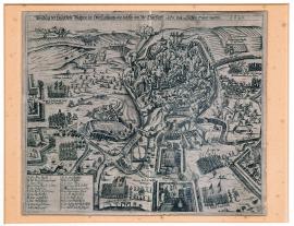
Plzeň, On
11.11.1618The picture of Pilsen is painted from a bird’s eye view with accurate details of various buildings. The attack of general Mansfeld’s armed forces is targeted at the Franciscan church. At the right upper corner is the emblem of the town of Pilsen in a decorated field. On the same side down there is legend A-I in a four-edge cartouche. On the left side down there are two riders, of whom one is holding a flag, and a few infantrymen. At the left upper corner is the inscription “Obsidio urbis Pilsenae”.
Signature: Not available
Autor: Unknown
Original name: Abbildung der Statt Pilsen in Böhmen und wie selbige durch Gen. von Mansfeld belägert und eingenommen worden. Anno 1618.
Katalogová čísla: Collection Český Šternberk, kód: 5/196
Pilsen was struck as soon as the Thirty Years’ War began. When after the Prague defenestration the Czech estates wanted to extort their requirements towards the emperor by threatening with war, Pilsen stayed on the side of the emperor who sent a small troop commanded by the county representative Felix Dorheim to defend it. In September 1618, the earl Arnost of Mansfeld hired by the Czech estates arrived in Bohemia and his soldiers started to besiege the hostile Pilsen immediately. With the reinforcements from the neighbouring regions, his army rose to include 8,000 men with whom he intensively tried to seize the town for 9 weeks. Both the crew and the burghers defended themselves bravely. However, when two holes were shot through the town walls, the besiegers succeeded in intruding the town (in the place of the today’s savings bank close to the Franciscan monastery) during the main attack on 21 November 1618. On the morning of 22 November, the town surrendered to Mansfeld who then settled in the emperor’s house. Pilsen was severely affected by the siege: one third of houses were reduced to ashes and destroyed by shooting. Suburbs with considerable supplies of food were destroyed completely.
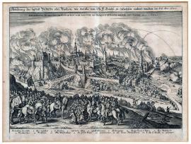
Plzeň, On
21.11.1618The town of Pilsen is drawn with good prospects. From the west, Mansfeld’s army is getting into the town through the ruptures in the town walls. At the left upper corner there is a camp of Mansfeld’s army. On the right up there is the emblem of Pilsen and down is the Radbuza river and the orienteering compass. At the left bottom corner there is a decorative cartouche with legend A-M.
Signature: G. Keller
Autor: Unknown
Original name: Abrisz der Statt Pilsen in Böhmen, wie dieselbige belägert, gestürmt und eingenommen worden.
Katalogová čísla: Collection Český Šternberk, kód: 6/168
General Arnost earl Mansfeld arrived to help the Czech estates. This army was hired for the Duke of Savoy and the Protestant Union, but in order not to spoil the relationship between the League and the Union, it was declared that the army was created and intended for the Czech estates. Thus, with the Czech directorate’s consent, Mansfeld arrived in Bohemia and on 21 November 1618 he conquered Pilsen, by which the emperor suffered considerable loss since there was only Ceske Budejovice left on the emperor’s side. Pilsen was always known for its loyalty to the emperor and the fact that it was controlled by Mansfeld without financial help from the Union and the Duke of Savoy. The fact that his army was plundering the whole region outrageously was very embarrassing and non-opportunistic for the emperor.
České Budějovice, On
01.01.1619 (do 31.12.1619)At the front in the engraving is the town of Budejovice with walls, towers and gates, and in the background is a hilly panorama with trees, the military troops, the artillery, and the individual soldiers. The picture makes an impression of the town being only watched and experiencing only small raids against the fortress rather than the actual siege. The terrain outside the town indicates that the combat was targeted in the direction out of the town, which points to the estates’ armies not acting too belligerently.
Signature: Not available
Autor: Unknown
Original name: Aygentlicher Abrisz der Belägerung der Statt Budtweisz, im Königreich Během, wie solche mit Königschem Volck besetzt, und von den Behemen in dieszem 1619 Jahr belägert.
Katalogová čísla: Collection Český Šternberk, kód: 7/33 D
In 1618, during the estates uprising, Budejovice remained loyal to the emperor. For this reason, the states’ first military action was targeted against Budejovice. In June 1618, the earl Thurn arrived there with 4,000 men. The municipal representative Aulner of Birkenfeld promptly recruited mercenaries with whom he defended the town until the emperor’s military forces commanded by the general Buquoy arrived in November of the same year. After Buquoy left, the command over the municipal crew was assumed by the Spanish general don Baltasar Maradas. Upon the Battle of White Mountain, Ferdinand confirmed and multiplied the privileges of Budejovice.
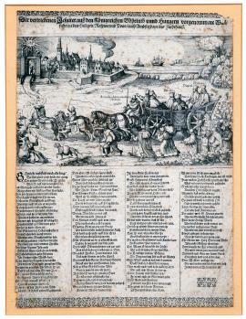
On
01.01.1619 (do 31.12.1619)Seven Jesuits are travelling in a big wagon drawn by six horses. The horses are wearing caps with the Czech and Hungarian emblems and another emblem on the shield of which is an open book. The travelling Jesuits are called as P. Colovrat, P. Haynal, P. Forro, P. Rumer, P. Caldi, P. Faminus, and P. Arnoudus, attorney-at-law from the Curia in Paris. There is a big group of priests walking along the wagon and loaded down with baggage and bags. In the background is a burning monastery from which the Jesuits have just been expelled; not far away, there is a monk sitting on his baggage and resignedly waiving his hand. Towards him there comes the dog loaded down with bags as well and having the devil’s tail. In the left background is a town with a port to which there leads the way the Jesuits are taking, that is, “via ad sanctum Raspinum”. Under the picture the Jesuit Order is continuously defamed and denigrated. This ends by calling on the Jesuits sarcastically to humbly and resignedly undergo the punishment waiting for them in the Amsterdam prison.
Signature: Not available
Autor: Unknown
Original name: Der vertriebenen Jesuiter ausz dem Königreich Böheimb und Hungern vorgenommmene Wallfahrt zu dem heiligen Raspino und Pono nach Ambsterdam ins Zuchthaus.“
Katalogová čísla: Collection Český Šternberk, kód: 14/142
It is a promotional defamatory article issued by the Protestants strongly criticising the Jesuits expelled from the Czech Crown countries in 1619. It is known that Jesuits always were the most agile anti-reformists and propagators of the Catholic religion and, therefore, a powerful support of the Roman-German emperor, which may easily justify the measure by which they were affected after the Czech uprising. However, after the Battle of White Mountain, they returned to Bohemia and took part in a very intensive catholic reformation of the country. The goal of their pilgrimage to St. Raspin and Pon, as it is stated on the graphics, remains unexplained.
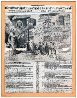
On
01.01.1619 (do 31.12.1619)The printing is depicting the sleeping emperor Ferdinand II, sitting on the throne under the canopy decorated with the Austrian eagle. Before him is Jesus Christ with a whisk in his hand. On the flag is the slogan: “In hoc signo vinces!” Five robust men wearing soldierly costume and armed with weapons and shields are leaving the throne. These men represent the emperor’s warriors devoted to the emperor at all times. The sleeping Ferdinand symbolizes his persuasion that he can calmly rely on the justice of his matters. In the right background are the Prague defenestration and five hands holding the Czech uprising sword. There is the following inscription there: “God shall punish the five hands raised against him!” A short way off we can see five military troops in which a short slogan is always stated. The Czech troop: “We either achieve freedom, or the power of Ferdinand’s sceptre will be extended even more!” The Moravian troops: “We were deceived by the Czech and Dutch insect!” The Silesian troops: “We, the Silesians, will stand by the Czech if we were about to be hurt!” The Lusatian troops: “The ridiculed Lusatia played a bloody game!” The Austrian troops: “Our freedom cannot be larger than that under the today’s government!” Around the military troops a large number of various insects are flying, which symbolizes the anti-emperor propaganda predominantly led from abroad. On the left is a small rider in whom the earl Thurn’s statement that a heroic and happy commander, being Maximillian of Bavaria, is mentioned. All inscriptions are Latin. Under the picture are a four-stanza poem and an extensive German explanation of allegories, citing numerous Old Testament psalms and relating their significance to the topic of the picture.
Signature: Not available
Autor: Unknown
Original name: Denkwürdiges Geheimnusz einer allbereit erfüllten und noch zukünfftigen Prophecey, welche anzeigt den vergangenen und noch continuirenden Zustand des böhemischen Unwesens.
Katalogová čísla: Collection Český Šternberk, kód: 15/136
The leaflet was undoubtedly issued in the period between the Czech uprising and the Battle of White Mountain and expresses hope on the part of the Catholics in the emperor’s victory. What is remarkable is the large number of various thoughts, arguments, citations from the Bible, etc., by which the author tries to support the topic of his panting. The whole sheet shows the unlimited fantasy and inventiveness of the propaganda.
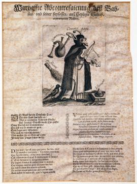
On
01.01.1619 (do 31.12.1619)The picture shows the Roman pope with the donkey head, stuck-out tongue and glasses. He is wearing the monastic cowl and is playing the violin (“opiniones”). Under him there lies a book on which is the human excrement (“disctinctiones”), bagpipes (“comentaria”), and the whisk (“questiones”). The pope’s clothes are pecked at by the magpie “Aristotle”. Under the picture are three poems, French, Latin and German, denigrating the pope with unscrupulous expressions.
Signature: Not available
Autor: Unknown
Original name: Wahrhaffte Abcontrafaictung desz Babstes und seiner heylossen ausz heiliger Schrifft erzwungenen Rechtes.
Katalogová čísla: Collection Český Šternberk, kód: 16/134
It is a very sharp pamphlet issued by the Protestants and being full of the lowest insults, which shows that the moral level and the sense of reality of part of the then publications were considerably warped. The whisk “questiones” is a satirical insinuation of the inquisition. The church’s standpoint in relation to various current issues is compared to the sound of the violin and the bagpipes. The magpie “Aristotle” symbolizes the fact that the philosophy of the Roman Church was identical, in many respects, with the Aristotle’s philosophy, in particular, when it comes to the opinion on natural sciences. The opponents of Catholicism considered and still consider this as the non-originality of the Christian philosophy and depicted a magpie (that is, the Roman church) stealing Aristotle’s brilliant thoughts, pretending these thoughts to be of their own.
Čechy, On
01.01.1619 (do 31.12.1619)It is a set of two small pictures depicting scenes representing the course and the characteristics of the political and religious events as they took place in Bohemia from 1618 to 1619. There is, for example, the scene where the fox and the wolf “in sheep’s clothing” are approaching the Czech wolf to persuade it of the dangers associated with the Evangelic religion. Other picture shows the cardinal Khesel and some Jesuit who are holding the canvas before the emperor Matthew sitting on the throne in order to prevent him looking at the arriving envoy who wants to present the requirements and complaints of the Czech estates. In the middle is a bigger picture with a big furnace heated by many Jesuits called as “superbia, arrogantia, avaritia”, etc. A small angel “providentia” is pouring water into the fire. This scene is satirical about the anti-reformation led, in particular, by the Jesuits. Under the picture is a very detailed legend explaining the depicted events. Nearly all persons are marked with letters and the legend always states accurately who is depicted and by whom which statement was expressed.
Signature: R.C.F. (R. Custos)
Autor: Custos R., vydavatel politických letáků zpočátku 30tileté války
Original name: Böhmischer Unruh-Schauspiegel, in welchem eine artliche und eigendliche Transfiguratio und Abbildung aller deren Handlungen, Aufstand und Thätlichkeiten so im vergangenen 1618 Jahr, auch bisz auff dato in dem hochlöblichen Königreich Böhmen vorgeloffen zu sehen.
Katalogová čísla: Collection Český Šternberk, kód: 17/139
This Protestant satirical leaflet is strongly targeted against the efforts of Catholic reformation made by the emperor and the Jesuits in Bohemia at the time of the Czech uprising. There are also pictures and statements of the cardinal Khlesel, Martinic, Slavata, Fabricius, the Czech peasantry, the representative of the Czech estates, a shopkeeper selling newspapers, and others. The emperor Matthew is depicted as a good-hearted old man controlled by radical advisors. The overall tendency of the leaflets makes the impression of conciliation and calls for patience and the endeavor to reach an agreement. Only the Jesuits are insulted sharply.
On
01.01.1619 (do 31.12.1619)MDCXIX. Fridericus I. rexhyemis XX, XXI, XXII, XXIII, XXIV, XXV, XXVI, XXVII, XXVIII, XXVIX, XXX & estatis: fit: sit & erat: Ingens: Bohemiae: In annos: Nestoris: fatis: Benigne: serios. In the middle of the printing is an oval portrait of Frederick Palatinate, framed on one side by roses and on the other by thorns. In his right hand, he is holding the marshal stick and has a wide collar around his neck resembling the mill wheel and a wide sash over his shoulder. On the right there is the Czech lion wearing a fur coat, in the background is a town with military camps, on the left is the Czech lion again, but this time without a fur coat, and a military troop marching in a hilly countryside. The above inscription is over the picture. Under the picture-based part of the printing is a German two-stanza poem praising the king and expressing the hope that once the winter is gone, the king’s military troops start to march towards victory and fame. In the last verse, the author is asking God to save the king Frederick and provide Czech people with peace and satisfaction.
Signature: Not available
Autor: Unknown
Original name: Das Friedrich dieses Namens der erste erwählter und gekrönter König in Böheimb, von vielen nur für einen Winterkönig, ausz den Worten, der ersten oberen Zeil schimpflich ausgerufen worden ist, und dasz aber das Gegentheil hier aus erscheint, bringen solches die folgenden Jahreszahls Buchstaben mit sich, das höchst ervelter König noch viel Jahr, Sommer und Winters Zeit über, durch Gottes sonderbare Allmacht ein König in Böheimb seyn und verbleiben werde.
Katalogová čísla: Collection Český Šternberk, kód: 18/122
Although the leaflet seems to be a pamphlet against Frederick Palatinate at first sight, it is actually intended to this unhappy Czech king’s benefit. The paper was issued in 1619, that is, prior to the Battle of White Mountain, and Frederick’s position was not unstable yet at that time. He could even rightfully hope for victory of the Czech uprising. Yet his opponent, the emperor Ferdinand, was at a very difficult situation at that time, not only owing to the disturbances in Bohemia but also owing to the rebellion of the Austrian Protestants and the danger coming from the west (Gábor Bethlen). Hence, the Czech rebels had a reason for viewing the future with trust. The stated leaflet is conceived in this spirit.
On
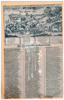
13.05.1619Under the Dutch inscription ‘Doemen 1567 Schreef, wast schade dat den Leev soo lang slapende bleet’ is a countryside with a sleeping lion and a wolf standing a short way off and fixedly gazing at the basket with seven goslings and two lambs. By the basket is a fox with a duck in its mouth and on the left the guard dog is tied up. Next to the guard dog is a donkey staggering and bending under the heavy load. Two men are sleeping close to the lion. In the background are illustrated scenes depicting people’s hardship and suffering in the ravaged country. Under the engraving are 4 poems (in Dutch, French, German and Latin) relating to the described picture. Other three-stanza poem is dealing with the scene depicted in a highly accurate fashion.
Signature: Im Jaar 1619 Francisco Antony exudebat.
Autor: Antony Francisco, holandský mědirytec
Original name: Der Niederlandsche schlaffende Louw.
Katalogová čísla: Collection Český Šternberk, kód: 11/62
The engraving is characterizing the political development of the Netherlands of the time when Philip II of Spain appointed the Duke of Alba his vicegerent in the Netherlands. Since then the Spanish started to viciously oppress the Dutch, which was followed by long-time war conflicts interrupted in 1609 by twelve-year truce entered into by Philip III with seven Dutch provinces: Holland, Seelandsk, Utrecht, Geldern, Overiejl, Frieslandsk and Groning. Since then, these so-called ‘general estates’ formed a republic. This period is depicted by the engraving: the Dutch sleeping lion represents the truce that had just been entered into. The persons depict the internal disturbances, in particular, religious, evoked by two reformed theological movements – Gomarusa and Arminianci. This dispute was intruded by the sly statesman Oldenbarnefeld depicted as a fox in a restless environment, putting the lion to sleep in order to uninterruptedly swallow one of the seven geese with the help of the wolf (Spain), that is, Utrecht. The remaining geese are representing the other countries of the general state. The declining donkey loaded down with guns is symbolizing the military defeat of Oldenbardenfeld’s uprising while the tied barking dog is representing the political parties standing against Oldenbardenfeld who was defeated by Maurice Orange of Nassau (the republic’s vicegerent) and then captured and executed.
Frankfurt na Mohanem, On
09.09.1619The engraving depicts the act of coronation on 9 September 1619 in Frankfurt am Main. On Wednesday, the king is kneeling by the altar and the Koln archbishop is putting the crown on his head. They are surrounded by dignitaries holding the sword, the sceptre and the imperial apple. On the next field another scene is depicted: the king sitting on the throne under the imperial eagle is dubbing several men; on the sides there are tribunes from which crowd is observing the act. Under the picture on the right there is the following text: Ferdinandus hier gesalbt wirt zum Röm. Kayser und geziert mit Scepter, Schwert, Ring, Apfel, Cron, Mayntz solchs mehrentheils verrichtet schon. On the other side is the same text in Latin. In the middle under the picture are coins scattered amongst people (ausgeworfene Münz) on the occasion of the coronation. The coin is a hand partially covered by the clouds and holding the crown. On the hand is a ribbon with the inscription: “Legitime certantibus”. On the back side of the coin is the inscription: “Ferdinandus secundus Hungariae et Bohemiae Rox coronatus in reegem Romanorum, IX. Sept. MDCXIX”.
Signature: Not available
Autor: Unknown
Original name: Grönung ihrer Mayt. Königs Ferdinandi II. Römischen Kayser 1619.
Katalogová čísla: Collection Český Šternberk, kód: 12/58
At the beginning of 1619, the emperor Ferdinand II found himself in a very difficult situation. The Czech estates army led by Thurn stood outside Vienna and only the determined intervention on the part of the colonel St. Hilair freed the emperor from the insisting Lower Austria estates of the Protestant confession. At the same time, it was a relief for him that Buquoy defeated Mansfeld close to Záblatí in Bohemia on 9 June 1619 and the Czech directors, fearing Buquoy’s further interventions, promptly called up Thurn to return to the country. Thanks to this, Ferdinand had a free way to the coronation in Frankfurt am Main. With his procession, he went through Munich where he was ostentatiously and heartily welcomed by the duke Maxmillian of Bavaria who even promised him help in case the Protestant Union wanted to take charge in Bohemia, which he had omitted before out of far-sighted carefulness. Thus, based on these facts, Ferdinand II arrived in the coronation town of the Roman-German emperors – Frankfurt am Main. He was accompanied by his loyal Czech estates, being Vaclav from Vrbno, Maxmilian from Valdštejn, William Vratislav from Mitrovice and Jiří from Náchod. The Chancellor of the Czech Kingdom Zdeněk Vojtěch from Lobkowicz had already arrived in Frankfurt before. However, even the Czech Protestant estates sent their representatives to Frankfurt to present their requirements of the non-Catholic Czech estates. Nevertheless, they were not allowed to participate in the coronation. The Palatinate envoys participated in the coronation, but there was nothing left for them but to silently hope that Ferdinand would be deprived of the Czech crown soon.
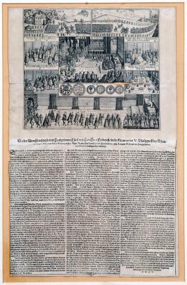
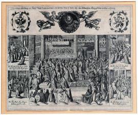
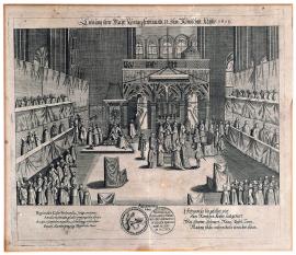
Praha, On
04.11.1619The picture is divided into 9 fields in which the individual acts of coronation are depicted in detail: A. The welcome ceremony in the Hvězda castle in White Mountain. B. The arrival in Hradčany. C. The ceremonial procession towards the place of coronation. D. The king’s unction. E. The coronation. F. The Czech estates’ oath to the king. G. The king is dubbing lower nobility representatives. H. The depiction of coins minted on the occasion of the coronation. I. The ceremonial lunch after the coronation. – Under the picture is an extensive text describing the whole event in detail and legend A-I.
Signature: G. Keller
Autor: Unknown
Original name: Wie der durchlauchtigste und hochgeborene Fürst und Herr, Herr Friedrich dieses Namens der V. Pfalzgraff bey Rhein, Herzog in Ober und Nieder Bayern des heil. röm. Reichs Ertz Trucksesz und Churfürst etc. zum König in Böheimb zu Prag gesalbt /confirmiert/ und gekrönet worden.
Katalogová čísla: Collection Český Šternberk, kód: 13/302
Frederick Palatinate, the so-called “winter king”, arrived in Prague on 31 October 1619 and was greeted by the representatives of the Czech estates, country, capital, etc. close to the Hvězda castle. It is noteworthy that the act of greeting was also participated by a group of the peasantry holding the Hussite flag and armed with the originally known Hussite armour and wagons. The main person in the coronation (alongside the king) was the administrator, that is, the head of the Calvin Church in Prague. It is obvious that it was necessary to quickly adjust the coronation ceremonials and the etiquette to the Calvin religion because the common coronation rules were predicated on the Catholic religion. The king was enthroned on 4 November 1619 and the queen was enthroned 3 days later.
On
01.01.1620 (do 31.01.1620)The picture part of the printing is divided into four fields depicting four scenes from the ceremonial tribute paid by the Austrian estates to Ferdinand II: 1. Emperor’s procession led by Ferdinand on the horse and with the crown and the scepter. In front of him is a courtier whose privilege is to carry the emperor’s sword. 2. Scene when the estates’ oath is read in the presence of the emperor on the throne. 3. Estates’ greetings intended for, and their tribute paid to, the emperor. 4. Ceremonial feast when the emperor is sitting at his own small table close to which is a big table at which the estates representatives are dining, at the front are musicians.
Signature: Not available
Autor: Unknown
Original name: Kayserliche Huldigung von den Ständen in Oesterreich.
Katalogová čísla: Collection Český Šternberk, kód: 19/159
After his coronation, Ferdinand II experienced a lot of troubles. An uprising flared up in the Czech Crown countries, from the east the emperor was jeopardized by attacks of the seven-castle prince Gabor Bethlen, and in the inherited countries the non-Catholic estates rebelled and even jeopardized the emperor in his residence in Vienna. However, the determined intervention of his loyal army managed to liquidate the Austrian storm. Then Ferdinand left for the coronation as the Roman emperor to Frankfurt am Main on 9 September 1619. During his way to Frankfurt, an agreement was reached in Munich with respect to the war alliance between Ferdinand II and Maxmillian of Bavaria – the duke of Bavaria and the head of the Catholic League – an alliance of the Catholic principality within the Holy Roman empire. Maximillian did not support the Habsburgs at the beginning but despite this, he had his army fought by the emperor’s side after the outbreak of the Thirty Years’ War. Thanks to this, Ferdinand’s position of power so consolidated that the Austrian estates considered as appropriate to express their loyalty towards the emperor after emperor’s return to Vienna, which expression of loyalty is the topic of this engraving. It was at the beginning of 1620.
On
01.01.1620 (do 31.12.1620)The picture depicts a large group of princes and monks headed by the Pope, who have started to panic as a consequence of some sort of natural disaster. The princes are desperately raising their hands towards the heaven, are falling to the ground and yelling. The pope has fallen down from his descending horse. On the ground are rosaries, praying books, crosses, bells, and the pope’s tiara and cross. From behind the cloud there comes a bright beam with the following inscription: “Pope, pope, why are you following me?” (The same words heard by Pavel of Taras outside Damask). The rain and hails are falling. Under the picture is a German three-stanza poem explaining the depicted event and calling on the readers to reject the Roman church’s efforts for catholic reformation.
Signature: Gedruckt zu Rom in Bapst Agnes Triumphgasses, Anno MDCXX
Autor: Unknown
Original name: Aygensinnige, halsstarrige Vervolgung, desz nunmehr in aller Welt geoffenbahrten Antichrists, des Bapstes zu Rom. welche er wider fromme Gottliebende Christen nun viel Jahr hero feindselig und tyrannischer Weisz für genommen.
Katalogová čísla: Collection Český Šternberk, kód: 29/129
The Protestant promotional leaflet drastically condemning the Catholic efforts (emperor, pope and Jesuits) to have the lapsed Czechs returned to the Church. The sheet states the bishops Becker, Bader and Khlesel as radical Catholic officials. The first two of them are quite unknown. Khlesel operated within the scope of the Catholic reformation, but for his lenient action towards the Lutherans, he was imprisoned in the Tyrol at the time of Matthew’s death, was grounded in Angel Castle and returned to his diocese in 1627. The poem deals with the pope punished by God, that is, by a natural disaster, close to Budejovice, Krumlov and Jindřichův Hradec on his way to Prague for persecuting non-Catholic Christians viciously. This means Thurn’s military success close to the stated towns over the imperial generals Buquoy and Dampier. However, Thurn failed to instruct the imperial church points as to the “injustice and perversity” of their behavior but rather inflicted “blindness” on the pope since the persecution of the reformed Czechs deteriorated even more.
On
01.01.1620 (do 31.12.1620)On the right side of the engraving is a big room with curtains (that is, the spinning mill), where there is the pope on the throne with a sword and the keys. On both sides of the throne there sit several Jesuits spinning threads. By the table are members of the Catholic League. On the left side is the Czech lion driving the Jesuits out of the Czech countries to Rome. In the heaven is God condemning evil souls and calling up the good souls through the angel. At the bottom there is a German-Latin poem detailing the depicted theme.
Signature: Gedruckt zu sich dich für Durch Christianum von Warenhausen und Traw jnen nit vil MDCXX.
Autor: Unknown
Original name: Abrisz einer Wundersettzamen mehr dann Sathanischen Spinnstuben von dem Sattaunischen Ottergescheys zu Unterdruckung in vielen vornehmen Ländern und Provincien Reiner Evangelischer Religion erdacht aber von Könige aller Königen zu nichte gemacht.
Katalogová čísla: Collection Český Šternberk, kód: 30/80
The leaflet was issued by the Protestants and criticized the pope’s policy at the time after the Czech uprising. The threads spinning by the Jesuits at the pope’s request shall mean the plans and intentions of the pope’s policy, led in agreement with the Catholic League and the emperor (that is, 5 persons at the table) against the Evangelicals’ efforts to maintain the power in some countries. The Czech lion that managed to drive the Jesuits out of Bohemia after the Czech uprising is considered by the author of the leaflet as the instigator of the significant success of the reformation.
On
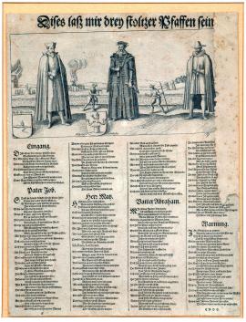
01.01.1620 (do 31.12.1620)The printing depicts three men in various costumes, close to whom there are the shields with emblems. Two messengers have just met behind the third men. One of these men is carrying a tray and the other is carrying a spear and a leaf. In the background is the countryside with a burning house and a bonfire on which some person is burning. On the right is a crowd of people desperately clasping their hands and confusedly running from one place to another (probably the emigrants). Under the picture part of the printing is an extensive German poem pointing to the three depicted persons called as Peter Job, Herr Matz and Vater Abraham. Each of them is expressing himself on the religious situation after the Battle of White Mountain.
Signature: Not available
Autor: Unknown
Original name: Dieses lasz mir drey stoltzer Pfaffen sein!
Katalogová čísla: Collection Český Šternberk, kód: 31/79
The leaflet very aptly characterizes the religious relationships after the Battle of White Mountain. In fact, Peter Job is P. Lamormain whose first name is William and who is a Jesuit born in Luxembourg in 1570 and who died in 1648 in Vienna. In 1590, he acceded to the Jesuit Order and in 1614 he became the rector in Štýrský Hradec and later in Vienna. Since 1624 he had been Ferdinand II’s confessor, gained great influence over him and was one of the main powers of the anti-reformation. However, he opposed the Valdštejn and the Spaniards. His correspondence with Ferdinand II was issued in 1867 by Dudík. Herr Matz was actually Matyáš Hoe von Hoheneck, Lutheran theologian, who was born in Vienna in 1580 and died in Dresden in 1645. In 1602, he became the courtyard preacher in Dresden, in 1603 the superintendant in Plavná and in 1613 the chief courtyard preacher in Dresden. He completely controlled the weak Saxon elector John George I and demanded that he be on the emperor’s side in the outbreak of the Thirty Years’ War and conclude, in 1635, the so-called Prague peace with the emperor after the short hostility. Vater Abraham is Abraham Scultetus, a Calvinist and the courtyard preacher of Frederick Fels (the Czech “winter king”). He was born in Grünberg in 1566, was a professor in Heidelberg and died in Emden in 1625. It is obvious that the religious opinions expressed in the poem by these three personas significantly differed. The author of the printing concluded and deduced that it was not good if rulers were subordinated to the influence of their spiritual advisors, but that it was good when they decided based on their own good semblance. We can see a very rare phenomenon when the author of the political leaflet of the 17th century stems from the objective standpoint and does not support any of the disputable parties.
Hradčany, On
01.01.1620 (do 31.12.1620)The engraving is divided into four fields: The first field depicts the Czech lion surrounded by thick, non-penetrable thorns (that is, the situation prior to the Czech uprising). On the next field is the lion who has just managed to get out of the thorn bush (that is, the Czech uprising). The third picture depicts Frederick Palatinate kneeling by the lying lion and removing the thorns from its injured legs. The last scene shows the king Frederick Palatinate peacefully strolling at large with the Czech lion; in the background is the panorama of Hradčany. Under the pictures are two-line Latin glosses and a German four-stanza poem describing the faith of the Czech lion until its liberation by Frederick Palatinate and ended by the wishful request that God grant long life to the king and increased the Czech fame.
Signature: M.P.F.S.
Autor: Unknown
Original name: Abrisz desz Böhmischen Löwens langwieriger harter Bedrangnüssen Qual und Trübsal sampt angehängter Curation und Heilung.
Katalogová čísla: Collection Český Šternberk, kód: 32/74
The engraving depicts, with no irony, the relationships in the Czech countries prior to the uprising in 1618 up to the election of Frederick Palatinate the Czech king. The winter king is described there as the liberator and the savior of the Czechs.
On
01.08.1620 (do 01.03.1621)It is a map of the Porýní (Kurfalc), around which 58 various towns, castles, fortresses, etc. conquered by Spinola’s army during the campaign through Lower Palatinate in 1620-1621 are drawn in small square fields. Under the picture part of the printing is a small portrait and the arms of the marquis Spinola.
Signature: Not available
Autor: Unknown
Original name: Geographische Delineation der Churpfaltz mit der Wetterauw undt angrensenten Herrschaften mit allen den Schlösseren en Stetten umgeben, welche Margiso Spinola von wegen Kayserlich Majest. Ferdinando secundo von Augusto 1620 bys auff Martium 1621 erobbert.
Katalogová čísla: Collection Český Šternberk, kód: 35/309
As soon as the uprising of the non-Catholic estates, which constituted a great danger for the continuity of the Roman-German empire, broke out in Bohemia in 1618 against the emperor, Ferdinand II was looking for allies who would help him face the danger. He elected, not accidentally (due to family and religious reasons), the Spanish king who satisfied the emperor’s request and promptly empowered the marquis Ambroz Spinola to recruit the army in the western countries and help the emperor suppress the rebelling non-Catholics. Thus, when Spinola was campaigning with his army towards central Europe, he invaded the hereditary country of the emperor’s opponent and the king of the Czech rebels Frederick Palatinate – Lower Palatinate – to stab into his most sensitive place. The beautiful and rich Palatinate was conquered and plundered by Spinola in less than a year. At the same time, there was the White Mountain catastrophe, by which the fate of Frederick Palatinate was sealed. The castles, fortresses and towns conquered by Spinola in Lower Palatinate in 1620-1621 are depicted in this engraving.
Linec, On
04.08.1620The engraving is typical of its distinctive front side (a big stump on the rock). In the middle is the town of Linz on the Danube. An army is marching on the bridge over the river. In the background is the panorama of a hilly countryside.
Signature: Not available
Autor: Unknown
Original name: Abrisz der Stadt Lintz von Ihrer fürstl. Durchlaucht in Bayern im im Namen der Kays. Mayt: eingenommen den 4. Augusti 1620.
Katalogová čísla: Collection Český Šternberk, kód: 20/48 D
When the alliance against the rebels in Bohemia was entered into between Maximillian of Bavaria and Ferdinand II, Maxmillian arrived, out of the blue, from Schärding to Upper Austria with his big army on 14 July 1620. This unexpected event caused panic. Some Upper-Austria estates confusedly paid tribute to Maxmillian while others, led by Lord of Tschernembel. After a short opposition, Linz was conquered on 4 August 1620. Then Maxmillian of Bavaria crossed the Czech borders by Frystadt and headed inland to unite with Buquoy standing with his army by Zwettle in Lower Austria, close to the Czech borders.
On
17.08.1620 (do 15.01.1621)On the graphics are 45 small square pictures of towns, fortresses, castles and strongholds. The last three fields remained empty. In the middle is the oval portrait of the marquis Spinola with the marshal stick on the horse, around is the military staffage. Over the table is the above German explanatory text. Under the pictures is a detailed German description of Spinola’s campaign through Lower Palatinate in 1620-1621, ended by the prayer towards God for peace and general satisfaction.
Signature: Zu Augspurg bey Andreas Güntsch Kupfferstecher bey Barfusser Thor.
Autor: Unknown
Original name: Wahrhafftige Abbildung derjenigen Stätt und Schlösser, welche Ihr. Excell. Marquis Ambrosius Spinola General im Namen der Röm. Kay. May. in der Chur-Pfalz am Rhein eingenommen, wie zu sehen hernach folgt.
Katalogová čísla: Collection Český Šternberk, kód: 34/299
As soon as the uprising of the non-Catholic estates, which constituted a great danger for the continuity of the Roman-German empire, broke out in Bohemia in 1618 against the emperor, Ferdinand II was looking for allies who would help him face the danger. He elected, not accidentally (due to family and religious reasons), the Spanish king who satisfied the emperor’s request and promptly empowered the marquis Ambroz Spinola to recruit the army in the western countries and help the emperor suppress the rebelling non-Catholics. Thus, when Spinola was campaigning with his army towards central Europe, he invaded the hereditary country of the emperor’s opponent and the king of the Czech rebels Frederick Palatinate – Lower Palatinate – to stab into his most sensitive place. The beautiful and rich Palatinate was conquered and plundered by Spinola in less than a year. At the same time, there was the White Mountain catastrophe, by which the fate of Frederick Palatinate was sealed. The castles, fortresses and towns conquered by Spinola in Lower Palatinate in 1620-1621 are depicted in this engraving.
Budyšín, On
07.09.1620 (do 05.10.1620)The picture depicts in detail the course of conquering Budyšín. The burning town is depicted in the middle; fights are raging around between the Saxon and Lusatian armies. You can see a lot of square military structures, the chances, the firing positions of the artillery and the camp. Minor scenes are accompanied with succinct explanatory inscriptions. In the bottom third of the picture is a rosette showing the cardinal points. On the left is legend A-Y.
Signature: Not available
Autor: Unknown
Original name: Abbildung der Hauptstadt Bautzen in der Oberlausitz, wie dieselbe von Ihrer Churfürstlichen Gnaden von Sachsen erobert worden 1620.
Katalogová čísla: Collection Český Šternberk, kód: 21/185
Already at the beginning of the Czech uprising, the Saxon elector John George I decided to support the emperor against the rebelling Czech estates. In planning the military counter-measures against the rebels, both time and local cooperation between the emperor’s, Bavaria’s and Saxon’s armies was agreed. Based on this agreement, John George I, Elector of Saxony left for Lusatia with his army in September 1620, besieged Budyšín on 5 September, and conquered it on 5 October, that is, approximately a month before the Battle of White Mountain. Although John George I of Saxony was a Protestant, his policy showed, nearly throughout the period of the Thirty Years’ War, certain favor for emperor’s central power in the empire, with reservation of the tolerant and just relationship between both main religions. However, when the radical Catholics around Ferdinand frustrated these efforts of the Saxon elector, he found himself, out of a sudden, in the battle of Breitenfeld in 1631 at the side of Gustav Adolf of Sweden.
Budyšín, On
07.09.1620 (do 05.10.1620)On the elevation there lies the town of Budyšín in flames and smoke. The trajectories of the bullets from mortars are marked with curves. At the front is John George I of Saxony on his horse and behind him is a troop with flags. There is a group of captives kneeling by his feet and escorted by a group of riders led by the commissioned officer taking his hat off to the elector. Under the above text is the Latin inscription: “Delineatio Budissini obsessi ab electore Saxoniae ab obsequium mense septembri anno 1620”. Legend 1-15 follows.
Signature: Not available
Autor: Unknown
Original name: Abbildung der Stat Budissin oder Bautzen, wie dieselbe von Ch. F. Durchlaucht zu Sachsen erobert worden im Sept. 1620.
Katalogová čísla: Collection Český Šternberk, kód: 22/200
Already at the beginning of the Czech uprising, the Saxon elector John George I decided to support the emperor against the rebelling Czech estates. In planning the military counter-measures against the rebels, both time and local cooperation between the emperor’s, Bavaria’s and Saxon’s armies was agreed. Based on this agreement, John George I of Saxony left for Lusatia with his army in September 1620, besieged Budyšín on 5 September, and conquered it on 5 October, that is, approximately a month before the Battle of White Mountain. Although John George I of Saxony was a Protestant, his policy showed, nearly throughout the period of the Thirty Years’ War, certain favor for emperor’s central power in the empire, with reservation of the tolerant and just relationship between both main religions. However, when the radical Catholics around Ferdinand frustrated these efforts of the Saxon elector, he found himself, out of a sudden, in the battle of Breitenfeld in 1631 at the side of Gustav Adolf of Sweden.
Budyšín, On
07.09.1620 (do 05.10.1620)The engraving is made in detail but relatively non-artificially. In the middle is Budyšín in fire. On the left is a cartouche with an oval portrait of John George I of Saxony with an inscription and elements. Over the picture is the inscription stated above. At the left bottom corner is legend A-Z in a square field. Under the picture part of the printing is a German text with four paragraphs explaining the topic of the picture with a lot of details, for example, the accommodation of the commissioned officers in the town, a list of buildings and various types of property destroyed by the fire, etc.
Signature: Peter Isselburg excudit Norimbergi
Autor: Isselburg Peter, mědirytec z Norimberka
Original name: Wahre Abbildung der Hauptstatt Budissin oder Bautzen in der Oberlausitz, wie dieselbe von dem durchlauchtig. Hochgeb. F. und H. Johann Georgen Hertzogen zu Sachsen Churfürstl. der röm. kays. Majestät hochansehlichen Commisario und des Grafen Wolf zu Mansfeld ihr. Chur. Gn. Generalleutnampt den 30. Augusti Anno 1620 belägert und 25. September erobert worden.
Katalogová čísla: Collection Český Šternberk, kód: 23/399
Already at the beginning of the Czech uprising, the Saxon elector John George I decided to support the emperor against the rebelling Czech estates. In planning the military counter-measures against the rebels, both time and local cooperation between the emperor’s, Bavaria’s and Saxon’s armies was agreed. Based on this agreement, John George I of Saxony left for Lusatia with his army in September 1620, besieged Budyšín on 5 September, and conquered it on 5 October, that is, approximately a month before the Battle of White Mountain. Although John George of Saxony was a Protestant, his policy showed, nearly throughout the period of the Thirty Years’ War, certain favor for emperor’s central power in the empire, with reservation of the tolerant and just relationship between both main religions. However, when the radical Catholics around Ferdinand frustrated these efforts of the Saxon elector, he found himself, out of a sudden, in the battle of Breitenfeld in 1631 at the side of Gustav Adolf of Sweden.
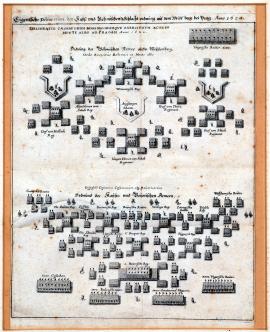
Bílá Hora, On
08.11.1620The engraving schematically depicts the battle position of the imperial and Bavarian armies (in the printing below) and the Czech estates soldiers (up). The tactical concept of both muster shapes significantly differs, in particular, when it comes to the sequence of the individual types of weapons. The regiments and their commanders are marked with names at their stations.
Signature: přisuzováno Abelinově, resp. Merianově „Theatru Europaeu
Autor: Abellnus, spoluvydavatel světových dějin "Theatrum Europeum", vydaných M.Merianem ve Frankfurtu nad Mohanem
Original name: Eigentliche Delineation der Kays. und Böhmischen Schlachtordnung auf dem Weissen Berg bei Prag 1620.“ Ordnung der Böhm. Armee auffm Weissenberg. – Ordnung der Kayser. und Bayerischen Armeen.
Katalogová čísla: Collection Český Šternberk, kód: 24/13
The consequence of the Czech uprising in 1618 was the war between the Czech estates and the emperor whom Maxmillian of Bavaria came to help. The conflict resulted in the unlucky Battle of White Mountain on 8 November 1620. The Czech estates had hastily several chances built in White Mountain in order to reinforce the Czech army’s position in the battle that was about to break out soon. The number of the estates’ soldiers is estimated to approximately 20,000 men who, however, were partially untrained and undisciplined. After the beginning of the battle, it was also necessary to hastily call to arms a lot of commissioned officers and soldiers from Prague to their battleground. On the morning of 8 November, the earl Christian of Anhalt, commander of the estates’ armies, built an arc-shaped army in White Mountain, one side of which was formed by the newly built fortifications and the other reached for the Hvězda castle’s enclosure. The left side was protected by a steep slope. In the back were Hungarian riders. Matthew Thurn recommended an immediate attack against the enemy as the army was lining up and mustering. Anhalt agreed with this opinion, but Hohenlohe advised to wait for the enemy’s attack and the steady position of their army. His tactical plan was finally accepted by the other commanders. There also existed disputes between the commanders of the imperial and Bavaria armies as to how to launch the attack. The duke of Bavaria and Tilly promoted immediate attack, while the emperor’s general Buquoy (who got injured not long ago) considered the Czech position as too strong for direct attack. The Spaniard William Verdugo agreed with the Bavaria commanders’ opinion. When the Bavarians started their attack and defeated the estate’s advanced patrols, the emperor’s army had nothing left but to proceed forward and join the Bavarians’ attack. Maxmillian of Bavaria tactically delayed the advancement of his units so as not to interrupt the continuous front line of both armies. However, Tilly’s and Tiefenbach’s first attack was demolished by the counter-attack of the riders of the younger prince of Anhalt. Emperor’s two regiments, Lichenstein’s and Bauer’s, commanded by the colonel Kratz rectified the defeat of their Bavarian allies. At that very moment, the Hungarian riders mustered from the Czech side to complete Anhalt’s victory. However, when the Hungarian riders noticed that the situation changed to their disadvantage in the meantime, they started running away confusedly and made the foot soldiers run away too. The enemy made use of the opportunity and completed his victory by advancing quickly. Everyone on the Czech side was running away, only Matthew Thurn and the younger earl Šlik obstinately defended themselves along with their renowned Moravians by the enclosure wall until nearly all of them were slaughtered. Šlik was taken captive and Thurn then fled abroad through Prague. The fateful defeat in White Mountain was so completed.
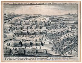
Bílá Hora, On
08.11.1620The engraving depicts the beginning of the Battle of White Mountain. At the front are the imperial and Bavarian armies; first clashes between both opponents are taking place in the middle. The Czech estates’ army starts running away on the top of the mountain. In the right background is the city of Prague and on the left is the enclosure of the Hvězda castle. At the bottom is a three-line legend with letters A-H.
Signature: Not available
Autor: Unknown
Original name: Tabula I. Delineationis Aciei et pugnae ad Pragam Bohemiae Metropolim factae 7. Novemb. 1620.
Katalogová čísla: Collection Český Šternberk, kód: 25/16
The consequence of the Czech uprising in 1618 was the war between the Czech estates and the emperor whom Maxmillian of Bavaria came to help. The conflict resulted in the unlucky Battle of White Mountain on 8 November 1620. The Czech estates had hastily several chances built in White Mountain in order to reinforce the Czech army’s position in the battle that was about to break out soon. The number of the estates’ soldiers is estimated to approximately 20,000 men who, however, were partially untrained and undisciplined. After the beginning of the battle, it was also necessary to hastily call to arms a lot of commissioned officers and soldiers from Prague to their battleground. On the morning of 8 November, the earl Christian of Anhalt, commander of the estates’ armies, built an arc-shaped army in White Mountain, one side of which was formed by the newly built fortifications and the other reached for the Hvězda castle’s enclosure. The left side was protected by a steep slope. In the back were Hungarian riders. Matthew Thurn recommended an immediate attack against the enemy as the army was lining up and mustering. Anhalt agreed with this opinion, but Hohenlohe advised to wait for the enemy’s attack and the steady position of their army. His tactical plan was finally accepted by the other commanders. There also existed disputes between the commanders of the imperial and Bavaria armies as to how to launch the attack. The duke of Bavaria and Tilly promoted immediate attack, while the emperor’s general Buquoy (who got injured not long ago) considered the Czech position as too strong for direct attack. The Spaniard William Verdugo agreed with the Bavaria commanders’ opinion. When the Bavarians started their attack and defeated the estate’s advanced patrols, the emperor’s army had nothing left but to proceed forward and join the Bavarians’ attack. Maxmillian of Bavaria tactically delayed the advancement of his units so as not to interrupt the continuous front line of both armies. However, Tilly’s and Tiefenbach’s first attack was demolished by the counter-attack of the riders of the younger prince of Anhalt. Emperor’s two regiments, Lichenstein’s and Bauer’s, commanded by the colonel Kratz rectified the defeat of their Bavarian allies. At that very moment, the Hungarian riders mustered from the Czech side to complete Anhalt’s victory. However, when the Hungarian riders noticed that the situation changed to their disadvantage in the meantime, they started running away confusedly and made the foot soldiers run away too. The enemy made use of the opportunity and completed his victory by advancing quickly. Everyone on the Czech side was running away, only Matthew Thurn and the younger earl Šlik obstinately defended themselves along with their renowned Moravians by the enclosure wall until nearly all of them were slaughtered. Šlik was taken captive and Thurn then fled abroad through Prague. The fateful defeat in White Mountain was so completed.
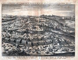
Bílá Hora, On
08.11.1620The sheet represents the Battle of Big Mountain drawing to its unlucky end. At the front are the emperor’s and Bavarian armies fiercely attacking the Czech estates army the fighting continuity of which is broken. The defeated soldiers are running away towards Prague that is painted in the right background of the picture with the Vltava river and the stone bridge. The scattered Hungarian riders are drowning in the river. On the left is the royal enclosure with the Hvězda castle. Under the picture is two-line legend with letters A-H.
Signature: Not available
Autor: Unknown
Original name: Tabula II. Bohemorum aciei a Cesareanis et Bavaricis die VII. Nov. 1620. Profligatae Delineationem exhibens.
Katalogová čísla: Collection Český Šternberk, kód: 26/17
The consequence of the Czech uprising in 1618 was the war between the Czech estates and the emperor whom Maxmillian of Bavaria came to help. The conflict resulted in the unlucky Battle of White Mountain on 8 November 1620. The Czech estates had hastily several chances built in White Mountain in order to reinforce the Czech army’s position in the battle that was about to break out soon. The number of the estates’ soldiers is estimated to approximately 20,000 men who, however, were partially untrained and undisciplined. After the beginning of the battle, it was also necessary to hastily call to arms a lot of commissioned officers and soldiers from Prague to their battleground. On the morning of 8 November, the earl Christian of Anhalt, commander of the estates’ armies, built an arc-shaped army in White Mountain, one side of which was formed by the newly built fortifications and the other reached for the Hvězda castle’s enclosure. The left side was protected by a steep slope. In the back were Hungarian riders. Matthew Thurn recommended an immediate attack against the enemy as the army was lining up and mustering. Anhalt agreed with this opinion, but Hohenlohe advised to wait for the enemy’s attack and the steady position of their army. His tactical plan was finally accepted by the other commanders. There also existed disputes between the commanders of the imperial and Bavaria armies as to how to launch the attack. The duke of Bavaria and Tilly promoted immediate attack, while the emperor’s general Buquoy (who got injured not long ago) considered the Czech position as too strong for direct attack. The Spaniard William Verdugo agreed with the Bavaria commanders’ opinion. When the Bavarians started their attack and defeated the estate’s advanced patrols, the emperor’s army had nothing left but to proceed forward and join the Bavarians’ attack. Maxmillian of Bavaria tactically delayed the advancement of his units so as not to interrupt the continuous front line of both armies. However, Tilly’s and Tiefenbach’s first attack was demolished by the counter-attack of the riders of the younger prince of Anhalt. Emperor’s two regiments, Lichenstein’s and Bauer’s, commanded by the colonel Kratz rectified the defeat of their Bavarian allies. At that very moment, the Hungarian riders mustered from the Czech side to complete Anhalt’s victory. However, when the Hungarian riders noticed that the situation changed to their disadvantage in the meantime, they started running away confusedly and made the foot soldiers run away too. The enemy made use of the opportunity and completed his victory by advancing quickly. Everyone on the Czech side was running away, only Matthew Thurn and the younger earl Šlik obstinately defended themselves along with their renowned Moravians by the enclosure wall until nearly all of them were slaughtered. Šlik was taken captive and Thurn then fled abroad through Prague. The fateful defeat in White Mountain was so completed.
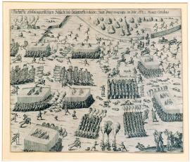
Bílá Hora, On
08.11.1620The engraving depicting the Battle of White Mountain is carried out very primitively. At the right upper corner is the enclosure of the Hvězda castle, on the left is a burning village. The space between the square military formations is strewn with dead, injured and fleeing soldiers of the Czech estates, at the right bottom corner are three buglers.
Signature: Not available
Autor: Unknown
Original name: Wahrhaffte Abbildung der blutigen Schlacht und Haupttreffens bey der Statt Praag vorgangen im Jahr 1620 Monats Octobris.
Katalogová čísla: Collection Český Šternberk, kód: 27/359
The consequence of the Czech uprising in 1618 was the war between the Czech estates and the emperor whom Maxmillian of Bavaria came to help. The conflict resulted in the unlucky Battle of White Mountain on 8 November 1620. The Czech estates had hastily several chances built in White Mountain in order to reinforce the Czech army’s position in the battle that was about to break out soon. The number of the estates’ soldiers is estimated to approximately 20,000 men who, however, were partially untrained and undisciplined. After the beginning of the battle, it was also necessary to hastily call to arms a lot of commissioned officers and soldiers from Prague to their battleground. On the morning of 8 November, the earl Christian of Anhalt, commander of the estates’ armies, built an arc-shaped army in White Mountain, one side of which was formed by the newly built fortifications and the other reached for the Hvězda castle’s enclosure. The left side was protected by a steep slope. In the back were Hungarian riders. Matthew Thurn recommended an immediate attack against the enemy as the army was lining up and mustering. Anhalt agreed with this opinion, but Hohenlohe advised to wait for the enemy’s attack and the steady position of their army. His tactical plan was finally accepted by the other commanders. There also existed disputes between the commanders of the imperial and Bavaria armies as to how to launch the attack. The duke of Bavaria and Tilly promoted immediate attack, while the emperor’s general Buquoy (who got injured not long ago) considered the Czech position as too strong for direct attack. The Spaniard William Verdugo agreed with the Bavaria commanders’ opinion. When the Bavarians started their attack and defeated the estate’s advanced patrols, the emperor’s army had nothing left but to proceed forward and join the Bavarians’ attack. Maxmillian of Bavaria tactically delayed the advancement of his units so as not to interrupt the continuous front line of both armies. However, Tilly’s and Tiefenbach’s first attack was demolished by the counter-attack of the riders of the younger prince of Anhalt. Emperor’s two regiments, Lichtenstein’s and Bauer’s, commanded by the colonel Kratz rectified the defeat of their Bavarian allies. At that very moment, the Hungarian riders mustered from the Czech side to complete Anhalt’s victory. However, when the Hungarian riders noticed that the situation changed to their disadvantage in the meantime, they started running away confusedly and made the foot soldiers run away too. The enemy made use of the opportunity and completed his victory by advancing quickly. Everyone on the Czech side was running away, only Matthew Thurn and the younger earl Šlik obstinately defended themselves along with their renowned Moravians by the enclosure wall until nearly all of them were slaughtered. Šlik was taken captive and Thurn then fled abroad through Prague. The fateful defeat in White Mountain was so completed.
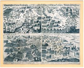
Bílá Hora, On
08.11.1620The engraving depicts the military campaign and the subsequent Battle of Big Mountain on 8 November 1620 in four scenes: A) Army’s position close to Rakovník. B) Beginning of the Battle of Big Mountain. C) The battle is raging to full extent. D) The estates’ soldiers are running away towards Prague. The pictures are very detailed and well elaborated, but the engraver’s work is not very good.
Signature: Not available
Autor: Unknown
Original name: Abrisz beyder Keyserischen und Böhmischen Feldläger und derauff erfolgten blutigen Schlacht und Niederlag der böhmischen Armada im Prager Revier.
Katalogová čísla: Collection Český Šternberk, kód: 28/317
The consequence of the Czech uprising in 1618 was the war between the Czech estates and the emperor whom Maxmillian of Bavaria came to help. The conflict resulted in the unlucky Battle of White Mountain on 8 November 1620. The Czech estates had hastily several chances built in White Mountain in order to reinforce the Czech army’s position in the battle that was about to break out soon. The number of the estates’ soldiers is estimated to approximately 20,000 men who, however, were partially untrained and undisciplined. After the beginning of the battle, it was also necessary to hastily call to arms a lot of commissioned officers and soldiers from Prague to their battleground. On the morning of 8 November, the earl Christian of Anhalt, commander of the estates’ armies, built an arc-shaped army in White Mountain, one side of which was formed by the newly built fortifications and the other reached for the Hvězda castle’s enclosure. The left side was protected by a steep slope. In the back were Hungarian riders. Matthew Thurn recommended an immediate attack against the enemy as the army was lining up and mustering. Anhalt agreed with this opinion, but Hohenlohe advised to wait for the enemy’s attack and the steady position of their army. His tactical plan was finally accepted by the other commanders. There also existed disputes between the commanders of the imperial and Bavaria armies as to how to launch the attack. The duke of Bavaria and Tilly promoted immediate attack, while the emperor’s general Buquoy (who got injured not long ago) considered the Czech position as too strong for direct attack. The Spaniard William Verdugo agreed with the Bavaria commanders’ opinion. When the Bavarians started their attack and defeated the estate’s advanced patrols, the emperor’s army had nothing left but to proceed forward and join the Bavarians’ attack. Maxmillian of Bavaria tactically delayed the advancement of his units so as not to interrupt the continuous front line of both armies. However, Tilly’s and Tiefenbach’s first attack was demolished by the counter-attack of the riders of the younger prince of Anhalt. Emperor’s two regiments, Lichtenstein’s and Bauer’s, commanded by the colonel Kratz rectified the defeat of their Bavarian allies. At that very moment, the Hungarian riders mustered from the Czech side to complete Anhalt’s victory. However, when the Hungarian riders noticed that the situation changed to their disadvantage in the meantime, they started running away confusedly and made the foot soldiers run away too. The enemy made use of the opportunity and completed his victory by advancing quickly. Everyone on the Czech side was running away, only Matthew Thurn and the younger earl Šlik obstinately defended themselves along with their renowned Moravians by the enclosure wall until nearly all of them were slaughtered. Šlik was taken captive and Thurn then fled abroad through Prague. The fateful defeat in White Mountain was so completed.
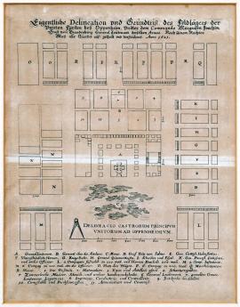
Oppenhaim, On
01.01.1621 (do 31.01.1621)It is a schematic plan of the military camp in symmetrical squares. At the front is a swamp under which is the measuring scale. Over the picture part of the printing is the above text, under which are legends: A-R and 1-11. This sketch is a significant document for the war history of the 17th century since it accurately depicts the organization (local) of the military encampment. The printing depicts accommodation, battle, administrative premises, the intendancy stocks, etc.
Signature: Not available
Autor: Unknown
Original name: Eigentliche Delineation und Grundrisz des Feldlägers der unierten Fürsten bey Oppenheim undter dem Commando Markgrafen Joachim Ernst von Brandenburg Generalleutnaant derselben Armee. Nach seinem rechten Masz alle Quartiere ausgeteilt und verzeichnet. Anno 1621.
Katalogová čísla: Collection Český Šternberk, kód: 33/332
When inimical armies started to concentrate in Bohemia and the adjacent countries after the Czech uprising, the armies of the so-called Protestant Union was also created on the upper Rhine. The Union shall mean the association of Protestant princes of the German opponents of the emperor, who supported Frederick Palatinate in his endeavors for the Czech throne. This new army of the Protestant Union was to attack the marquis Spinola, commander of the Spanish armies, campaigning towards the lower Fels. The army of the Union was then commanded by the margrave Arnošt Jáchym of Brandenburg who substituted for Arnošt Mansfel, the field marshal Frederick Palatinate. The margrave of Brandenburg led the military operations very unskillfully and with complete failure so he was suspected of having an agreement with Spinola. The defeat of the Czech estates in White Mountain finally led, alongside these failures in Lower Palatinate, to the liquidation of the Protestant Union. Oppenheim, the place of the military camp of the Union’s army, lies approximately 20 km south from Mohuč.
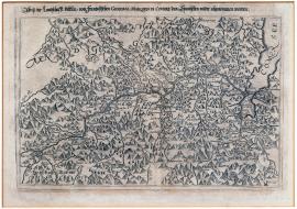
jezero Como, On
01.01.1621 (do 31.12.1621)The engraving depicts the territory northwards from the Como lake along the Addy valley in the today’s province Sondrio. On the right side of the picture is the lake Como. The whole countryside is scattered with mountains with countless identifications of various places. Over the picture are the cited text and the legend.
Signature: Not available
Autor: Unknown
Original name: Abrisz der Landschaft Veltlin, vom französischen General marquis di Covure den Spanischen wieder abgenommen worden.
Katalogová čísla: Collection Český Šternberk, kód: 45/335
After 1620, the Spanish and Austrian armies appeared in Grisonsk (Graubünden), which also affected the interests of the adjacent regions, in particular, Veltlin that was part of Grisonsk for a certain period of time. Spain and Austria both pursued the support of the Catholics against the Swiss Calvinists and wanted to besiege the strategically important Alpine passes. France, which was obstinately waging war in several places under the command of Richelieue against Spain, sent an army headed by the general marquis di Covur to Veltlin, defeated the Spanish there and besieged the territory. Veltlin was an extremely strategically important territory for all the parties involved in the war. There led the so-called Spanish path on which the armies and material were streaming to the Spanish Netherlands and along which there were important commercial routes. Thus, France and Spain competed with the Habsburg empire.
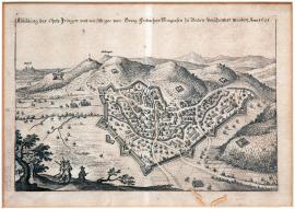
Ihringen, On
01.01.1621 (do 31.12.1621)The small picture depicts the hilly countryside on the foot of which is the fortified town Ingringen. There are the chances depicted among various hillocks. In the background are the towns of Brysach and Höhingen. At the front are several trees and two musketeers. Over the picture is the text stated above.
Signature: Not available
Autor: Unknown
Original name: Abbildung des Ohrts Iringen von Georg Friedrich Markgrafen zu Badeen verschantzet worden. Anno 1621.
Katalogová čísla: Collection Český Šternberk, kód: 46/266
George Frederick margrave of Baden-Durlach recruited Swiss mercenaries and equipped the army of approximately 8,000 men with arms. His army was equipped with excellent artillery and special wagons from which it was possible (similar to the Hussite war wagons) to build a fortress in a short time. This army was prepared to defend the Czech king Frederick Palatinate. To this effect, the margrave of Baden arrived in Breisgau and closed the access to upper Rhine for the archduke Leopold who collected his army in Alsace. George Frederick of Baden also obstructed the way for the Spaniards campaigning towards the Netherlands against the emperor’s foes. He besieged the bridges across the Rhine and various strongholds and fortresses, for example, Brysach. To the same effect, he fortified Ihringen lying on the foot of Kaiserstuhl and being extremely fitting for his strategic intentions.
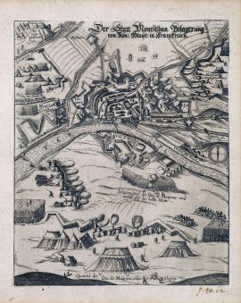
Mont Alban, On
01.01.1621 (do 31.12.1621)The engraving depicts the fortified town (from above) at the bank of the river Tar (correctly: Tarn). The correct name of the besieged town is Montauban. The town lies in the Tarn et Garonne department. At the left corner there is the king’s main tent depicted on the hill. The above inscription is stated on the engraving.
Signature: Not available
Autor: Unknown
Original name: Der Statt Montalban Belagerung von König. Mayst. in Frankreich.
Katalogová čísla: Collection Český Šternberk, kód: 47/87
It is an episode from the long and bloody fight between the French government and the Hugenots. It was a sect of French Calvinists that was cruelly persecuted for several years. The siege of the town of Montauban in the south of France was part of this fight and was led by king Ludvík XIII in 1621.
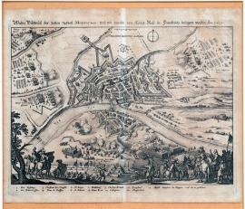
Mont Alban, On
01.01.1621 (do 31.12.1621)The front side of the picture shows the groups of soldiers and buglers. There is the river Tarn flowing in the centre of the countryside. On its bank there lies the fortress Montauban. On the left near the river Lauarion is the king’s main tent – Pique Cox. Under the engraving is legend 1-13.
Signature: Not available
Autor: Unknown
Original name: Wahre Bildnusz der vesten Statt Montauban und wie die selbe von Königl. May. in Frankreich belägert worden. Anno 1621.
Katalogová čísla: Collection Český Šternberk, kód: 48/55
It is an episode from the long and bloody fight between the French government and the Hugenots. It was a sect of French Calvinists that was cruelly persecuted for several years. The siege of the town of Montauban in the south of France was part of this fight and was led by king Louis XIII in 1621.
On
01.01.1621 (do 31.12.1621)Through the small ovals structured to form a spiral, the graphics depicts 50 towns, castles and fortresses. In the middle are Spinola’s portrait and arms. Below is a Dutch and French text describing subjectively, from the perspective of the Spanish winners, the course of the Palatinate war in 1620-1621.
Signature: Not available
Autor: Verhoeven Abraham, tiskař v Antverpách
Original name: Nouvelle putraicture de toutes les villes, forteresses et chateaux, que son excellence le marquis Spinola á gangé et prit, tant en Allemagne comme au Palatinat aveque sa puissance militaire, depuis l´an 1620 jusques l´an 1621.
Katalogová čísla: Collection Český Šternberk, kód: 49/137
As soon as the uprising of the non-Catholic estates, which constituted a great danger for the continuity of the Roman-German empire, broke out in Bohemia in 1618 against the emperor, Ferdinand II was looking for allies who would help him face the danger. He elected, not accidentally (due to family and religious reasons), the Spanish king who satisfied the emperor’s request and promptly empowered the marquis Ambroz Spinola to recruit the army in the western countries and help the emperor suppress the rebelling non-Catholics. Thus, when Spinola was campaigning with his army towards central Europe, he invaded the hereditary country of the emperor’s opponent and the king of the Czech rebels Frederick Palatinate – Lower Palatinate – to stab into his most sensitive place. The beautiful and rich Palatinate was conquered and plundered by Spinola for less than a year. At the same time, there was the White Mountain catastrophe, by which the fate of Frederick Palatinate was sealed. The castles, fortresses and towns conquered by Spinola in Lower Palatinate in 1620-1621 are depicted in this engraving.
On
01.01.1621 (do 31.12.1621)A Anvers, par Abraham Verhoeven, imprimeur juré demerant sur la Lombaerde Veste, au soleil d´or 1621.The engraving depicts a wheel on the shaft spun by two men. There is Frederick Palatinate depicted on the wheel in three various positions symbolizing the individual phases of his troubled life. On the left he is holding onto the wheel and is going up. In the highest point in the middle is the king on the throne and on the right he is falling from the wheel down into the sea from which he is being got out by the Dutch fishermen. In the background is the hilly countryside and under the picture is a German two-stanza poem describing the unlucky fate of the Czech winter king.
Signature: Not available
Autor: Unknown
Original name: Dess gewesten Pfalzgrafen Glück und Unglück.
Katalogová čísla: Collection Český Šternberk, kód: 50/94
It is a political leaflet satirically describing and illustrating the picture of “fortune and misfortune” of Frederick Palatinate, a short-time Czech king. In the figure going up there is the additional inscription “Frederick Elector” whose significance and political power is growing. On the top of the wheel is “Frederick the king” ruling in the Czech kingdom and comparing himself with the powerful Roman-German emperor. On the right side lifeless Frederick is falling into the sea and is being got out to the coast by the Dutch fishermen. The fall into the chasm symbolizes Frederick’s defeat in White Mountain and Lower Palatinate. After the long and miserable pilgrimage, he finally found an asylum in Calvinist Holland (rescued by Dutch fishermen). The two persons spinning the wheel are Scultetus, Bedřich’s courtyard preacher, and Camerarius, his most powerful advisor.
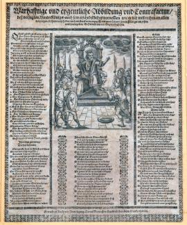
On
01.01.1621 (do 31.12.1621)The engraving represents the winter king Frederick wearing a fur coat and sitting on the throne. Instead of the scepter he is holding the Hussite mace. Along both sides of the throne there stand his commanders in classic military costumes and with shields depicting the signs of the northern (winter) constellations of Scorpio, Capricorn, etc. One of the military personas is passing the king two pieces of little fish in a bowl. Under the picture is a German three-stanza poem ridiculing Frederick Palatinate.
Signature: Getruckt zu Augspurg, In Verlegung Daniel Manassers Kupferstecher beym Klenckerthörlein.
Autor: Manasser Daniel, rytec a nakladatel v Augsburgu
Original name: Wahrhafftige und eygentliche Abbildung und Contrafactur desz verjagten Winterkönigs auch sein erschreckliches vornemmen wie er sich will rechen an allen denjenigen, so ihn veracht haben, auch wie stark er im Anzug ist und wo er sich mit seinem Feldläger am ersten wird hingeben, Gott wöll uns mit Gnaden beistehen.
Katalogová čísla: Collection Český Šternberk, kód: 51/55
It is a pamphlet ridiculing the Czech winter king Frederick Palatinate. The sheet stems from the ridiculous name “winter king” and names his commanders according to the winter months (November, December, January, February and March) or uses the names of the Catholic patrons whose remembrance is celebrated in the winter months, for example, Martin, Mikuláš, Baltazar, Blažej and others. The poem is ridiculously warning the west European countries against the danger of invasion on the part of the armies of the winter king who is going to avenge all the defeats suffered. However, at that time, Frederick was already a defeated expatriate fleeing westwards and seeking asylum from his pursuers.
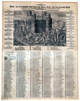
On
01.01.1621 (do 31.12.1621)The graphics depicts the Catholic church as a high, robust building with four towers symbolizing the emperor, the pope, the elector of Bavaria, and Spain. Strong chains pulled by various enemies of the church, being Frederick Palatinate, Bethlen Gabor, the margrave Krnovský, Kryštof of Dohna and several devils wanting to pull down the Roman church building, are fastened on the towers. At the right and left corners of the printing are the towns of Heilborn and Crailsheim where there was the so-called Anhalt’s office, that is, all correspondence and other written documents of the prince of Anhalt, the known instigator of the Czech uprising and the commander of the estates’ army in White Mountain. This documentary material considerably discredited both Anhalt himself and many other persons participating in the Czech uprising. After the Battle of White Mountain, Anhalt’s office became the emperor’s supporters’ booty and allowed them to accurately ascertain the rebels’ intentions and the level of their traitor activity. Around the picture are many statements of persons who either were involved in the Czech uprising or stood on the emperor’s side. Under the picture part of the engraving is an extensive German poem, the so-called “sincere warning” convincing the readers about the betrayal and immorality of the anti-Catholic uprising in 1618.
Signature: Not available
Autor: Unknown
Original name: Extrract der Anhaltischen Cantzley das ist Abrisz wie der Calvinische Geist durch seine gehaime Räth, wider das röhmische Reich und consequenter wider die catholische römische Kirchen practiciert, doch die Rathschläger ob ihren Practicken zuschanden werden.
„Was Glehrte durch die Schrift verstahn, Das lehrt das Gemähl den gemeinen Mann.“
Katalogová čísla: Collection Český Šternberk, kód: 52/84
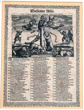
On
01.01.1621 (do 31.12.1621)In the engraving there is a post on which the imperial eagle is sitting and is holding a ring in its beak and a laurel twig under its wing. On its head is the imperial crown and under its left leg is the sun with the inscription: “Sol iustitae”. On the left is a shooter (England) who is aiming at the eagle and two men with spears (Mansfeld and the duke Krnovský), stabbing the eagle. However, their action is being prevented by two angels with shields containing the inscriptions: “It is useless!” and “Complete Mistake!” The fox (Bethlen Gábor) and the bear (the Netherlands) trying to pull the post down are leaning against the post. In front of the post is the deer (Braunschweig) digging under them. However, it is bitten by a snake. On both sides of the post there are the lion and lioness (Sweden) and the inscription: “We are watching!” Under the picture is a three-stanza poem.
Signature: Not available
Autor: Unknown
Original name: Wachender Adler. Iam vigilia vano nec somno deditu esto!
Katalogová čísla: Collection Český Šternberk, kód: 53/131
The leaflet issued by the emperor’s side illustrates the difficult political position of the Roman-German empire at the beginning of the Thirty Years’ War. The emperor’s foes are England, the Netherlands, Braunschweig, Mansfeld, the duke Krnovský, Bethlen Gábor, and Sweden that has not intervened in the fights yet but is lurking in the background. The poem describes in detail the jeopardy of the Holy Roman Empire by the stated enemies. The author is asking how the old Romans, Brutus, Corvinus, Manlius and others, would comment this situation. However, the imperial eagle is lurking and patrolling, is defeating all troubles and calling on the political neutrals to come to help him.
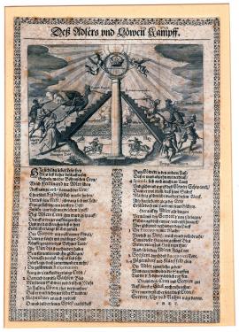
On
01.01.1621 (do 31.12.1621)In the centre of the picture is a post over which angels are holding a laurel wreath with the Czech crown and the scepter. There are stairs leading to the top of the post on which the Czech lion is standing on the left with the crown on its head and the cross (reformation) is falling opposite to it. The Saxon elector John George has injured the lion’s leg with his sword. The marquis Spinola (Spain) is pulling the lion’s tail and the duke Maxmillian of Bavaria is stabbing its left leg. On the other side of the stairs there is the imperial eagle on the head of which the sword is falling (that is, the execution of the Czech lords). Both Mansfeld and the duke Krnovský are shooting at the eagle and the seven-castle prince Bethlen is threatening the eagle with his sword. In the background behind the post there is the battle between Mansfeld and Maxmillian of Bavaria depicted. Under the engraving is a German two-stanza poem.
Signature: Not available
Autor: Unknown
Original name: Desz Adlers und Löwen Kampff.
Katalogová čísla: Collection Český Šternberk, kód: 54/60
The engraving symbolizes the fight between Ferdinand II and Frederick Palatinate for the Czech crown. On both sides there are barriers frustrating both rulers’ efforts. Frederick Palatinate is chased by Maxmillian of Bavaria, Spinola and John George of Saxony. The cross falling on the lion’s head represents the intensive and precipitous introduction of the reformed church in Bohemia after the estates’ uprising to the new king’s disadvantage. On the other side, we can see the emperor’s enemies, being Mansfeld, Bethlen – attacking again after Buqouy’s death -, and the duke Krnovský. The sword that has fallen on the eagle’s head symbolizes the execution of the Czech lords in the Old Town Ring in 1621, which evoked repulsion towards Ferdinand II.
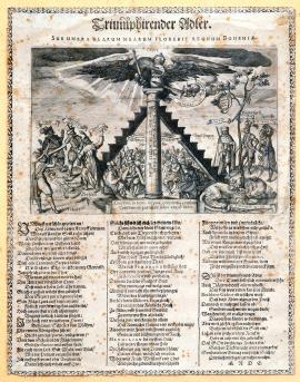
On
01.01.1621 (do 31.12.1621)On the post there is the eagle on the throne with the crown and the scepter. In the clouds there is a hand with a sword touching the imperial apple held by the eagle in its left talon. On the right side of the post there is standing Jan George I, Elector of Saxony and on the left Mansfeld, Bethlen and the duke Krnovský. Behind the post is a crowd of Czech, Moravian and Silesian people. At the front on the right there is lying the injured Czech lion from which a tree to which the sword and the shield are tied up is growing. Under the picture part of the graphics is an extensive rhymed German text.
Signature: Not available
Autor: Unknown
Original name: Triumphierender Adler, sub umbra alarum tuarum florebit regnum Bohemuae.
Katalogová čísla: Collection Český Šternberk, kód: 55/61
The engraving depicts, from the emperor’s perspective, the political situation after the victory over the Czech uprising. The winning imperial eagle is spreading out its wings over the subjugated countries of the Czech crown. His allies are marked with the inscriptions: sic volo, sic iubeo, sit pro ratione voluntas, etc. In the opponents of the imperial eagle is the inscription: iuro, moror, etc. In the injured Czech lion is the inscription: Fortunae causa – the fate. In the background are the Czech inhabitants whose opinions on the situation differ a lot. Some of them are lamenting, some cheering and some discussing lively. It is interesting that both this and the previous sheets (No. 54/60 on page 47) show the unusual impartiality of the author who even was not afraid of calling the execution of the Czech lords as an act that considerably damaged the emperor’s reputation in the Czech countries.
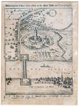
Türkheim, On
01.01.1621 (do 31.12.1621)It is a small high-altitude painting with the Rhein river with a bridge across it. A ship is painted on Rhein and Rhein-Türkheim lies on the shore. The upper part of the paintings shows the Stein castle, encircled with a water course and swamps. There is a Spanish camp, chances and various trees in the landscape. Above the painting, there is the aforementioned text, and below the painting is a legend.
Signature: Not available
Autor: Unknown
Original name: Abbildung der Kellerei zum Stein in der Churpfaltz am Rhein gelegen.
Katalogová čísla: Collection Český Šternberk, kód: 56/396
In the hereditary region of the Czech king Frederick Palatine, in Rhenish Palatinate, a war was waged against Spaniards lead by Ambrogio Spinola, 1st Marquis of the Balbases, who had conquered the entire Rhenish Palatinate. Later, Tilly took his forces there too. When a large rebellion of non-Catholic estates against the emperor erupted in Bohemia in 1618, a rebellion, which posed a great threat to the continuity of the Holy Roman Empire, Ferdinand II. was looking for allies which would help him face the danger. He selected – not by an accident – (because of reasons of religion and kinship) the Spanish king, who fulfilled the emperor's request and immediately commissioned Ambrogio Spinola to recruit an army in the western countries and help the emperor defeat the rebelling non-Catholics. So, when Spinola took his forces to Central Europe, he invaded the hereditary region of the emperor's enemy and the king of rebelling Bohemians, Frederick V, Elector Palatine – the Rhenish Palatinate, so that he could hurt Frederick in the most vulnerable place. Beautiful and rich Palatinate was conquered and devastated by Spinola in less than a year. At the same time, there was a crushing defeat in the Battle of the White Mountain, and so the fate of Frederick V, Elector Palatine and the fate of both his countries was sealed. Castles, fortresses and cities conquered by Spinola in the Rhenish Palatinate in 1620–1621 are depicted in this engraving.
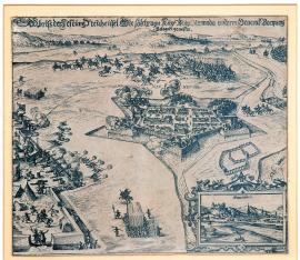
Nové Zámky, On
01.06.1621 (do 30.06.1621)The engraving maps the fortress Nové Zámky with five advanced chances and surrounded by water. From the fortress shots are being fired at the emperor’s camp located on the left. In the background behind the town, the riders clashed. On the right is the river Nitra. At the right bottom corner is a four-edge cartouche with a view of Bratislava. In the background are hills.
Signature: G. Keller
Autor: Unknown
Original name: Abrisz der Festung Neuheisel, wie solche von Kay. May. Armada underm General Buquoy belagert gewesen.
Katalogová čísla: Collection Český Šternberk, kód: 38/170
When the Czech uprising was liquidated by the imperial and Bavarian armies in the whole territory of Bohemia and Moravia, Buquoy and his army were sent to the east to fight against Bethlen Gabor, prince of the seven castles, who dangerously jeopardized the emperor’s possessions in the east. Even Bratislava was conquered by Bethlen when Dampierre’s attempt at conquering the town back failed. Dampierre himself died there (see page 368 in part II!). Bethlen Gabor aspired for the Czech crown, but when he was pushed out in this intention of his by Frederick Palatinate, the hatred against the Czechs who gave preference to other pretender arose inside him. His torn-apart and treacherous tamper caused that he continued fighting against the emperor. Buquoy intruded into Slovakia, seized Trnava, Staré Hrady and Bratislava. In besieging Nové Zámky, he died at the beginning of the fights as he and his riders came to help other riders defeated by the enemy. Bethlem gained courage and intruded, with the help of his allies, the margrave Krnovský and several Hungarian noblemen, into Moravia and his riding gaggles were plundering there severely. Only after Valdštejn’s intervention, Bethlen Gábor was defeated and concluded, upon agreement with the margrave Krnovský, the so-called Peace of Mikulov with the emperor. Nové Zámky was besieged by Buquoy in June 1621.
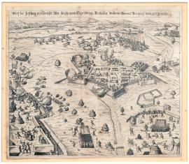
Nové Zámky, On
01.06.1621 (do 30.06.1621)The engraving depicts the fortress Nové Zámky in 1621. Except for the missing view of Bratislava, the graphics is nearly identical with sheet No. 38/170 on page 35. Only the riders’ clash is somewhat differently conceived. It is undoubtedly the fight in which Buquoy died. According to Drugulin G. Keller, both engravings are undoubtedly created by the same author and have the same dimensions.
Signature: Not available
Autor: Unknown
Original name: Abrisz der Festung Neuheusel wie solche von Kay: May: Armada underm General Buquoy belagert gewesen.
Katalogová čísla: Collection Český Šternberk, kód: 39/205
When the Czech uprising was liquidated by the imperial and Bavarian armies in the whole territory of Bohemia and Moravia, Buquoy and his army were sent to the east to fight against Bethlen Gabor, prince of the seven castles, who dangerously jeopardized the emperor’s possessions in the east. Even Bratislava was conquered by Bethlen when Dampierre’s attempt at conquering the town back failed. Dampierre himself died there (see page 368 in part II!). Bethlen Gabor aspired for the Czech crown, but when he was pushed out in this intention of his by Frederick Palatinate, the hatred against the Czechs who gave preference to other pretender arose inside him. His torn-apart and treacherous tamper caused that he continued fighting against the emperor. Buquoy intruded into Slovakia, seized Trnava, Staré Hrady and Bratislava. In besieging Nové Zámky, he died at the beginning of the fights as he and his riders came to help other riders defeated by the enemy. Bethlem gained courage and intruded, with the help of his allies, the margrave Krnovský and several Hungarian noblemen, into Moravia and his riding gaggles were plundering there severely. Only after Valdštejn’s intervention, Bethlen Gabor was defeated and concluded, upon agreement with the margrave Krnovský, the so-called Peace of Mikulov with the emperor. Nové Zámky was besieged by Buquoy in June 1621.
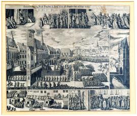
Praha, On
11.06.1621 (do 21.06.1621)The picture is divided into seven parts depicting various events associated with the conviction and execution of 27 Czech lords in the Old Town Square. The depicted episodes represent the pronouncement of the judgment, the presentation of the petition for pardon by the convicts’ wives and children, the convicts are transported in covered carriages to the Old Town Square Hall, the bloody execution on its own and the Old Town Square bridge tower to which the heads of the executed persons and the Jesenius’s tongue were fastened as a warning.
Signature: Not available
Autor: Unknown
Original name: Execution so zu Prag den 11. /21. Juny 1621 ist abgestellt und vollzogen worden.
Katalogová čísla: Collection Český Šternberk, kód: 36/358
A day after the defeat of the Czech estates’ army in White Mountain, Maxmillian of Bavaria arrived in Prague and started to command there. The city’s representatives and various significant personas paid him homage and asked for pardon. The far-sighted due of Bavaria carefully avoid interfering in the emperor’s monarchal rights in Bohemia, however, he dealt with the delegations coming to him politely and leniently. On 17 November, he left Prague and returned with his soldiers to Munich. In Prague he left only a small crew subordinated to the general Tilly. Buquoy treated his injuries and then campaigned towards Moravia. There was peace for a short time. On 20 February, the emperor’s vicegerent and prince Charles Lichtenstein had many of the persons participating in the Czech uprising arrested. Shortly thereafter, the court was called up and condemned most of the accused persons, of whom 27 were sentenced to death penalty. The court trial took quite a long time and Ferdinand II was called on to punish the rebels’ treason as strictly as possible. It was said that mainly Martinic, Slavata and the emperor’s confessor P. Lamorain were those who promoted such strict punishment. In the end, Lichtenstein was ordered by the emperor to carry out the execution of those sentenced to death on 21 July 1621 in the Old Town Square. In the evening before the execution, a lot of wives and children of the convicts came to Lichtenstein and asked for pardon for their husbands and fathers. However, he could not change the emperor’s decision even if he wanted to. On 21 June 1621, 27 convicts out of 43 were executed in the Old Town Square. The execution related to Jáchym Ondřej Šlik, Václav Budovec of Budov, Kryštof Harant of Polžice and Bezdružice, Kašpar Kaplíř of Sulevic, Prokop Dvořecký of Olbramovice, Bedřich of Bihle and Řehlovice, Jindřich Ota of Losy, Vilém Konecchlumský, Diviš Černín of Chudenice, Bohuslav of Michalovice, Leander Rippel, Jiří Hauenschild, the rector of the Charles University Jan Jesenuis, Jan Kutnauer and three others were hung. Twenty persons in total were executed with the permanent sound of drums in order to drown out any possible undesirable statements on the part of the convicts. Through this cruel intervention, the emperor completed his cruel victory over the Czech estates uprising.
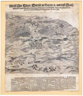
Rozvadov, On
15.06.1621 (do 15.07.1621)Signature: Not available
Autor: Sadeler R., mědirytec
Original name: Abrisz Ihr: Fürstl: Durchl: in Bayrn: etc. und des Manssfeldischen Lägers, wie sie beiderseits zu Rosshaupten in Böheim und zu Weydhausen in der Ober Churpfaltz gegen einander gelegen, im 1621Jahr.
Katalogová čísla: Collection Český Šternberk, kód: 37/6
The picture depicts a perspective view of the Šumava countryside from the east. In the background are the Šumava forest mountains, on the right down is the village Royvadov lying approximately 20 km west from Bor. Nearby is the town of Weidhausen in Bavaria. In the countryside there are scattered military troops, camps, fortifications, etc. Under the picture is legend 1-28. After the Battle of White Mountain, there were less extensive fights, in particular, in western and eastern Bohemia. Mansfeld, who became the field marshal of Frederick Palatinate in the meantime, so far kept Pilsen conquered in 1618 (see No. 5/196 on pages 4 and 5) and lost it only now. The Protestant Union knew that its resistance in western Germany would be successful due to the preponderance of the army of the Spanish marquis Spinola and, thus, it dispersed. However, its armies gathered in droves under Mansfeld’s flags concentrated close to Weidhausen, at the border of Upper Fels and Bohemia in mid 1621. Against him, in the Czech village Rozvadov, there was Tilly with his army standing against him and reinforced by the army of Maxmillian of Bavaria. However, in Mansfeld’s camp, epidemics spread soon due to the large number of unburied dead horses. Alongside this, it was necessary to urgently help Frederick’s inherited Lower Palatinate affected by the Spanish invasion. For this reason, the camp close to Weidhausen was liquidated and Mansfeld moved to the northwest.
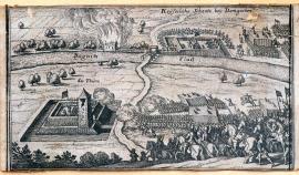
Damgarten, On
01.08.1621 (do 30.09.1621)It is a small picture, probably cut out from some work (maybe Theatrum Europaeum), with no specific time indication. It depicts riders with flags. On the left are the fortified tower and the river Regnitz across which a way is leading to the fortified camp with soldiers. In the background is fire.
Signature: Not available
Autor: Unknown
Original name: Kayserliche Schantz bey Damgarten.
Katalogová čísla: Collection Český Šternberk, kód: 40/222
It is not possible to determine exactly which war event was in question. However, it is highly probable (based on the indicated location) that the printing depicts a battle scene of the autumn 1621 in Upper Palatinate. Here (close to Weidhausen) there was the field encampment of Mansfeld’s army and frequent scuffles with the imperial army under the command of the general Tilly took place there. It was in the period when Mansfeld hastily left for Upper (Rhine) Palatinate to fight against the marquis Spinola. Regnitz is a small river flowing into Sala. The described territory lies approximately 20km westwards from the town of As.
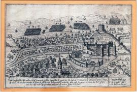
Wilhermsdorf, On
04.10.1621 (do 05.10.1621)In the picture is the town of Willhermsdorf upon Aurach lying 34km northwestwards from Norimberk, and the castle Bürckmischling with “Lusthaus” on the hill overgrown with grapevine. The river Aurach splits close the town into two arms, of which one flows around the castle that is the water stronghold. Over the castle is the coat of arms, undoubtedly owned by the family of the then holder. Both inside and around the town is the camping army. In the background are 4 military troops structured in the distinctive square shapes. The above text and legend 1-4 are under the picture part of the printing.
Signature: Not available
Autor: Unknown
Original name: Das Mansfeldische Volk, welches zu Ross 5.000 und zu Fuhs 13.000 stark gewest, bey sich habent 17 Stück Grob Geschütz und bey 2.000 Wagen ist anno 1621 den 4. October in dieszem abgebilten Ort Willhermsdorf ankumen, alldar mit der ganzen Armada über Nacht gelegen und den 5. disz wider uffgebrochen und nach der untern Pfalz marschiert.
Katalogová čísla: Collection Český Šternberk, kód: 41/175
The war against the Czech rebels ended by the conquest of Tabor in November 1621. However, before it happened, Mansfeld left for Upper Palatinate (westwards from Cheb) after he lost Pilsen. His army grew considerably when it was joined by many of those released from the liquidated Protestant Union. His situation in Upper Palatinate deteriorated when Tilly, the commander of the Catholic League, started to threaten him. When the infectious epidemics started to decimate his army in the camp in Weidhausen close to Koburk, Mansfeld decided to leave for Lower Palatinate. Through his skilful dealings with the emperor, he succeeded in covering his strategic movement so he appeared absolutely unexpectedly in Lower Palatinate. The depicted overnight stay of the whole army from 4 to 5 October 1621 in Wilhelmsdorf comes from the hurried march towards Lower Palatinate.
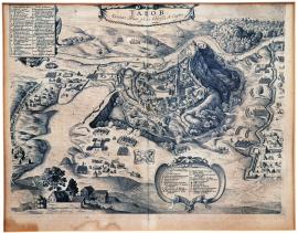
Tábor, On
13.11.1621The etching is made masterfully. However, based on the style, it is not made by Hollar but rather by Sadeler and is not signed. Tabor is depicted from above, the church tower is partially demolished and on the left is the pond Jordan. Around the town are military groups, chances, incursions, etc. Everything is engraved with an astonishing accuracy and carefulness. The cited inscription is over the picture. At the bottom is an extensive legend on a decorative vignette field.
Signature: Not available
Autor: Unknown
Original name: Tabor civitas anno 1621 obsessa et capta.
Katalogová čísla: Collection Český Šternberk, kód: 42/325
Ferdinand II was not happy with the victory in White Mountain and ordered to liquidate estates’ all supporting points that had not surrendered so far. However, this action was aggravated by the fact that Buquoy and a big part of the imperial army left eastwards to face the incursions of the seven-castle prince Bethlen Gabor. The Bavarian army commanded by Tilly was forced to march towards Lower Palatinate where Mansfeld started to move after the loss of Pilsen and several other west Bohemian towns. Thus, only the general Don Baltasar Maradas from Spain stayed in Bohemia and his task was to defeat, with not too many soldiers, the last point of the Czech estates resisting so far. After the heroic resistance, Tabor was conquered by agreement with his crew on 13 November 1621.
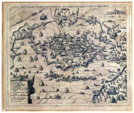
Frankenthal, On
20.11.1621 (do 30.11.1621)The town is painted from above. A short way off, the riders have clashed. On the left is Rhine and on the right is a forest with a small village and the church tower. Around the town are banks and chances. The trajectories of the cannon shots are depicted by curves. At the bottom on the left is a decorative cartouche with legend A-L.
Signature: Not available
Autor: Unknown
Original name: Abrisz der Stadt Franckenthal, wie solche von dem Vicegeneral Don Goncalo Fernandes de Cordova belagert worden. 1621.
Katalogová čísla: Collection Český Šternberk, kód: 43/194
The Spanish general Cordova was ordered by his commander, marquis Spinola, to fight with his large army against Lower Palatinate, the hereditary country of Frederick Palatinate. The conquest of numerous towns and strongholds required more time than originally expected. When Cordova was busy with besieging the town of Frankfurt upon Rhine, Arnst Mansfeld suddenly appeared in Lower Palatinate. The message of his arrival with an army of 25,000 men caused that Cordova immediately turned around from Frankenthal and left for Oppenheim, Kreuznach, Stein and other places to stay in the winter camps.
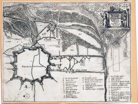
Frankenthal, On
20.11.1621 (do 30.11.1621)The picture depicts only the fortification facilities around the town of Frankenthal, the remaining part is empty. The flow of the river Rhine is depicted in the forest countryside. On the right side up there is a decorative cartouche with two figures of Fidelitas and Constantia, on which are the coats of arms and the above inscription. Under the picture of the printing are legends A-R and 1-12.
Signature: Deliniert durch Heinrich van der Borsch
Autor: Borcht Heinrich van der, nizozemský mědirytec
Original name: Belägerung der Statt Frankenthal im Jahr 1621.
Katalogová čísla: Collection Český Šternberk, kód: 44/218
The Spanish general Cordova was ordered by his commander, marquis Spinola, to fight with his large army against Lower Palatinate, the hereditary country of Frederick Palatinate. The conquest of numerous towns and strongholds required more time than originally expected. When Cordova was busy with besieging the town of Frankfurt upon Rhine, Arnošt Mansfeld suddenly appeared in Lower Palatinate. The message of his arrival with an army of 25,000 men caused that Cordova immediately turned around from Frankenthal and left for Oppenheim, Kreuznach, Stein and other places to stay in the winter camps.
On
01.01.1622 (do 31.12.1622)In front of us, there is a tableau of the Duke Christian of Brunswick and Wolffenbüttel, also called of Halberstadt, on horseback, without a hat, with a big sash, holding the Marshal’s cane in his right hand. There are 38 small viewpoints on different towns and castles, which he conquered, around his portrait. The entire engraving, although unsigned, indicates considerable artistic qualities of the author; especially the images of towns are very skillfully made.
Signature: Not available
Autor: Unknown
Original name: Abbildung der fürnehmbsten Orter in Westphalen und sunst so von Hertzog Christian in Braunschweig eingenommen.
Katalogová čísla: Collection Český Šternberk, kód: 80/113
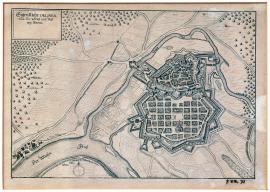
Hanau, On
01.01.1622 (do 31.12.1622)The schematic illustration of the town of Hanau, which lies close to the river Main, about 20 kilometers west from Frankfurt. A small river Künzig flows around the town. In the landscape, few individual trees are drawn. In the left top corner, there is a rectangle with an inscription above, without a given time and specification. Also, the image does not show, except for three cannons located in the town square, any military motives.
Signature: Not available
Autor: Unknown
Original name: Eigentliche Delineation der Statt und Vestung Hanau.
Katalogová čísla: Collection Český Šternberk, kód: 81/164
The town and fortress of Hanau is located very close to the battlefield of Hochst, where a great battle between Tilly and Christian of Brunswick – Halberstadt took place on 20 June 1622. In the context of this battle, there were without any doubt combat actions near Hanau which thematically inspired the author of this graphic to picture the town.
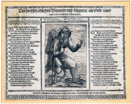
On
01.01.1622 (do 31.12.1622)In the middle of the engravings, an old man with devil horns, a massive beard, a wooden stump instead of his right leg is displayed together with the left leg of a bird covered with fish scales on calf and with a crutch in his armpit. The old man raises his right hand with a pointing finger, in his left hand, he holds a sheet of paper with a seal on which is written: 'The apprenticeship certificate of counterfeiters and moneylenders, down, deep to the hell!'. The back basket on his back is filled with similar sheets and inscriptions: 'We counts and nobles, clergy, we Jews, we traders', etc. The figure has a pouch with money attached to his waist and a rat's tail protrudes in the back. On both sides of the described image, there is a long German poem depicting intentions and activities of moneylenders and the easiest way how to become a moneylender and counterfeiter. In the next one, however, the poem warns against this vice, because it corrupts people and essentially leads to hell.
Signature: Gedruckt zu Augspurg, in Verlegeung Daniel Manassers, Kupferstechers, beim Klenkerthörlein.
Autor: Manasser Daniel, rytec a nakladatel v Augsburgu
Original name: Der hochschädlichen Wipperer und Kipperer, als Geld, Land und Leute verderber Lehr maister.
Katalogová čísla: Collection Český Šternberk, kód: 82/56
The Thirty Years' War, as all the wars, resulted in a general moral decline that was mainly manifested in the fact that a lot of people took advantage of a general breakdown and gained fortune by various intrigues and frauds. Counterfeiting money and usury were common among many plunderers. Our leaflet was no doubt supposed to show the harmfulness of these abuses and to act to rectify the situation.
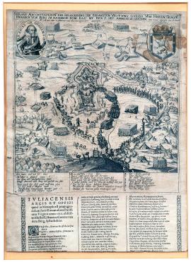
Jülich, On
03.02.1622The engraving is quite crude. In the centre, there is the Jülich fortress with troops marching around and enemy units leaving the town. Wide neighbourhood of the city is dotted with various chances, fortifications and military camps. A hill will gallows on top is in the foreground. A portrait of Henry, Count of Berg is in the left upper corner, on the right, there is a coat of arms with a lion. German description of the situation with marking of camps of Berg and Spinola is below the painting on the board. Under it, there is a detailed description of the event in Latin, which celebrated the heroism and credit of general of Berg.
Signature: Not available
Autor: Unknown
Original name: Wahre Abcontrafaitung der berümbten Vestung Gulch vom Herrn Graven Heinrich von Berg im Namen Röm. Kai. mt. den 5. September Annno 1621 geschen von newem abgeressen den 12. Decb. Anno 1622 den 3. Februar mitt Accord genommen.
Katalogová čísla: Collection Český Šternberk, kód: 57/154
Truce between the Netherlands and Spain only existed from 1609 to 1621. Then there were military conflicts between both countries again; the emperor of the Holy Roman Empire took the side of Spain. The Spaniards were lead by Marquise Spinola, Henry, Count of Berg was the commander of imperial forces. The siege of the Jülich fortress, which lies approximately 30 km to the west from Cologne, and which was conquered by general Berg on 3 February 1622, was one of the first joined battle actions against the Netherlands. The emperor's interest in the campaign was caused by the fact that House of Habsburg owned certain, very extensive, lands in the Netherlands (currently Belgium). The alliance with Spain was conditioned by common Catholic religion and the affinity of ruling houses. The House of Habsburg ownership of lands in the Netherlands lasted up to Napoleon I.
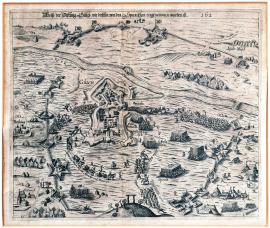
Jülich, On
03.02.1622The painting shows the Jülich fortress and city near the Dutch borders with its surroundings. The upper part of the painting shows the Roer (Ruhr) river, a wide circle of fortifications, chances and various fortification objects, military camps, movements of military units etc. A hill with gallows is in the foreground. Some settlements in the area are marked with names.
Signature: Not available
Autor: Keller G., mědirytec
Original name: Abrisz der Festung Gülch wie dieselbe von den Spanischen eingenommen worden ist. 162.. (1622).
Katalogová čísla: Collection Český Šternberk, kód: 58/178
Truce between the Netherlands and Spain only existed from 1609 to 1621. Then there were military conflicts between both countries again; the emperor of the Holy Roman Empire took the side of Spain. The Spaniards were lead by Marquise Spinola, Henry, Count of Berg was the commander of imperial forces. The siege of the Jülich fortress, which lies approximately 30 km to the west from Cologne, and which was conquered by general Berg on 3 February 1622, was one of the first joined battle actions against the Netherlands. The emperor's interest in the campaign was caused by the fact that House of Habsburg owned certain, very extensive, lands in the Netherlands (currently Belgium). The alliance with Spain was conditioned by common Catholic religion and the affinity of ruling houses. The House of Habsburg ownership of lands in the Netherlands lasted up to Napoleon I.
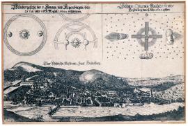
On
04.02.1622 (do 15.02.1622)Heidelberg above Neckar is depicted in the foreground, a hill with vineyards is on the right, above it is an inscription: “Chur Pfältzische Residentz Statt Heidelberg.” The aforementioned odd appearance of three suns and rainbows is painted on the sky, the sky is dotted with stars, a cross with two clouds and several rays of light is between the stars.
Signature: Not available
Autor: Unknown
Original name: Wundergesicht der 3 Sonnen und Regenboegen den 15. Jan: oder 4. Feb:N:Cal: 1622 erschienen. Seltzam Chasma Nachtszeit über Haydelberg den 5/15 Feber: 1622 gsehen.
Katalogová čísla: Collection Český Šternberk, kód: 59/34d
This is an atmospheric or other natural phenomenon, which was very rare and that is why it caused such interest. Similar phenomena played an important role in the 17th century, because it was customary to attribute them a supernatural significance; for example, it was believed that a large catastrophe, war or something similar will take place. The same opinion remained in people's minds in not so distant past: In 1914, the comet was being related to the World War I and an aurora borealis in 1939 was being related to the World War II.
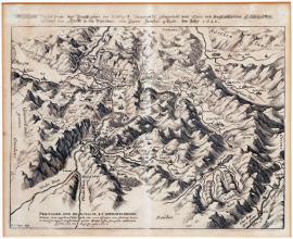
Pratigov, On
24.04.1622 (do 22.05.1622)We can see a hilly Swiss country with the Rhein river and Chur city, near which is a battle of armies, which come from all directions. Cities and villages are named. Territorial borders are marked with dotted line. Below the painting, there is the aforementioned text.
Signature: H. C. Gyger desig.
Autor: Gyger H. C., mědirytec
Original name: Wahrhaffte Verzeichnus desz Prattigöws der Herrschaft Meyenfeldt Gelegenheit umb Chur und angrenzender Landschaften sampt dem Treffen so die Pündtner mit ihren Feinnden gethan. Im Jahr 1622.
Katalogová čísla: Collection Český Šternberk, kód: 60/174
Already during the Reformation in 16th century, persistent conflicts and fights between Catholics and Calvinists were occurring in the Swiss canton Graubünden; these culminated in notorious slaughter of Calvinists and Protestants in Valtellina. In 1620, Swiss and Spanish army invaded Graubünden and garrisoned the entire land. However, constant fights with local population were occurring during this period – until the Calvinists managed to conquer the Chur fortress on 22 May 1622. The imperial-Spanish army, lead by colonel Balderon, withdrew. The reasons of the imperial campaign into Graubünden were not only religious, but in the first place, there was a strategic interest to seize important Alpine mountain passes. For the imperial ally – Spain, these passes were of vital importance, because they were a part of the so-called Spanish road, which enabled the Spanish crown to supply the armies in the Netherlands and in the Holy Roman Empire with supplies and soldiers. Because of Dutch ships and pirates, the sea route was off-limits for Spain.

On
28.04.1622 (do 08.05.1622)The engraving is very gently and carefully carved. In the middle, there is the town of Hagenau and the town’s emblem is above. In the foreground, chances, seven cannons, several tents, two men, a woman and a dog can be seen – in the background, we can see a forest. On the left, near the river Moder, we see the main tent of Archduke Leopold, the path leading to Strasbourg is on the right. Below the image, there are the explanatory notes: A-N.
Signature: Gedruckt bey Jac. von der Heyden
Autor: Heyden Jacob van der, holandský rytec a nakladatel se sídlem ve Strasburku
Original name: Anno MDCXXII den 28. April A. und 8. Mai neuen Calenders hat ihre hochf. Durchlaucht Erzherzog Leopold die Statt Hagenau belägert und den Vorwerken und Verschantzungen derselben so stark zugesetzt, dass die Garnison solche endlich verlassen und in die Statt gewichen, allda sich ritterlich gewehret bis ihr excellenz der Graff von Mansfeld sie entsetzt und der Erzherzog Leopoldus durch einen eyligen Auffbruch abgezogen.
Katalogová čísla: Collection Český Šternberk, kód: 62/182
It is the pamphlet which mocks the Bohemian King Frederick V, Elector Palatine, nicknamed the Winter King. It is based on the mocking nickname the Winter King, because it names his commanders according to the winter months (November, December, January, February, March), or the names of Catholic patrons whose commemoration is celebrated during winter months, e.g. Martin, Nicholas, Balthazar, Blaise and others. The mocking poem was supposed to warn West European states against the dangers of the invasion of the Winter King’s armies, who planned to revenge all the defeats he had suffered. In fact, Frederick was already a defeated refugee fleeing to West and looking for a refuge from pursuers at that time.
Hagenau, On
03.05.1622It is a schematically drawn city plan without figures and any staffage. In the right corner, there is a city coat of arms with a rose, on the left, there is a fortress founded by Mansfeld, which was subsequently closed down. Under the painting, there is a legend.
Signature: Not available
Autor: Unknown
Original name: Grundriss der Statt Hagenau.
Katalogová čísla: Collection Český Šternberk, kód: 61/109
After the defeat of the Bohemian revolt in 1620, the war moved to lands to the west from Cheb – into Upper Palatinate, where, however, the situation of marshal of Frederick V, Elector Palatine, Ernst von Mansfeld, became very difficult, mostly because of epidemic outbreak and because of strong pressure of Tilly's army from the south. That was why Mansfeld decided to withdraw to Rhenish Palatinate. He performed this tactic movement so skilfully that his enemies were completely surprised. The Spanish army, lead by Spinola and Cordoba, laid in Rhenish Palatinate; however, Mansfeld had avoided any encounter, taken Hagenau and forced the city to pay 100 000 gold pieces. Then he moved to Saarland because of supply reasons and he left a garrison in Hagenau. In the meantime, a situation, which lead to Tilly's victory over Protestant armies near Wimpfen on 8 May 1622, was created. After an unsuccessful attempt to take the city of Zabern in Alsace, Mansfeld returned to Hagenau, where in the meantime emperor's brother, archduke Leopold, was trying to reoccupy the city that was taken by Mansfeld. Five days before Tilly's victory at Wimpfen, Mansfeld had liberated Hagenau from encirclement of Leopold's armies at the eleventh hour; Leopold's armies retreated hastily.
Wimpfen, On
08.05.1622The engraving is done (superficially and apparently hastily) in the manner of maps; streams are drawn as in reality. Cities and villages are marked with their names. Heilbronn at the bottom left and Wimpfen at top right. The explanatory notes A to L contain explications of the depicted events. In the middle of the engraving, there is a distinguishable wagon fortification with the mark 'D'. There is the inscription above: 'Palatinatus', and: 'Pars Ducatus Würtenbergensis' is below.
Signature: Not available
Autor: Unknown
Original name: Abrisz der Schlacht, so zwischen Herrn Markgrafen von Durlach und Monsieur Tilly, als Kays. und Bayerischen Generalen vorgangen.
Katalogová čísla: Collection Český Šternberk, kód: 63/5
The first phase of the Thirty Years' War ended in the defeat of the Bohemian revolt. The centre of the combat moved from the Bohemia to the Rhine Palatinate, hereditary territory of Frederick V, Elector Palatine. He was regarded as the main representative of the Protestant opposition in the Empire by the Emperor. Frederick V, Elector Palatine's power position was shaken by the defeat of the revolting troops in the Battle of the White Mountain in 1620. But he was not alone in his fight. Many of his followers were involved in the campaign: Georg Friedrich, Margrave of Baden-Durlach, Christian the Younger of Brunswick, Ernest von Mansfeld and many more. They also received support from abroad, notably from the King James I of England, who was the father-in-law of Frederick V, Elector Palatine. The main commander of the Imperial-Bavarian army, who was appointed to lead the combat in the Palatinate, was the General Johann Tserclaes, Count of Tilly. One of the important events of the Palatinate campaign was the Battle of Wimpfen on 6 May 1622. Georg Friedrich, Margrave of Baden-Durlach encountered Tilly with the Spanish General Córdoba. Luck was on the side of the Catholic forces. Due to successful strategic actions, Tilly and Córdoba had a strong superiority. George Friedrich relied only on his 'wagenburg' – outdated tactics of armed wagons. The battle lasted from early morning until noon, when Tilly withdrew his troops to have a rest into the nearby Dornet forest. Margrave of Baden-Durlach had armed wagons in the middle of his formations and in the background, there is another group of armed wagons with supplies of ammunition. In the afternoon, Tilly launched a new attack on the 'wagenburg', which was unsuccessful at first but later he managed to destroy the ammunition supply by precise artillery which caused confusion in the Protestant army. Tilly’s troops then intruded into the enemy’s position and, at the same time, joined the attack of the Córdoba’s cavalry that consistently finished their task. The Protestant troops fled back over the Böllinger stream, which flowed behind them, but the only bridge was insufficient for a quick escape of the disorganized, defeated and completely destroyed army. Margrave of Baden-Durlach lost virtually the whole army here, so he withdrew hurriedly with only small remnants. He then sought refuge outside Germany, because the Emperor had given him the imperial ban.
Wimpfen, On
08.05.1622The engraving shows the progress of the battle in the clouds of blowing dust and smoke from exploding ammunition supply. On the left, there is the river Neckar and the Böllinger stream in the background, which as a natural obstacle caused catastrophic losses to the army of Margrave of Baden-Durlach during their escape. The town of Wimpfen is at bottom right. The battle wagons are clearly visible in the Protestant position. The given inscription is above the image, the explanatory notes A-R are below.
Signature: Not available
Autor: Unknown
Original name: Eigentliche Vorbildung des berübtnen Treffens so zwischen dem Markgrafen von Durlach und General Tilly bey Wimpfen vorgangen. Anno 1622 7. Mai.
Katalogová čísla: Collection Český Šternberk, kód: 64/18
The first phase of the Thirty Years' War ended in the defeat of the Bohemian revolt. The centre of the combat moved from the Bohemia to the Rhine Palatinate, hereditary territory of Frederick V, Elector Palatine. He was regarded as the main representative of the Protestant opposition in the Empire by the Emperor. Frederick V, Elector Palatine's power position was shaken by the defeat of the revolting troops in the Battle of the White Mountain in 1620. But he was not alone in his fight. Many of his followers were involved in the campaign: Georg Friedrich, Margrave of Baden-Durlach, Christian the Younger of Brunswick, Ernest von Mansfeld and many more. They also received support from abroad, notably from the King James I of England, who was the father-in-law of Frederick V, Elector Palatine. The main commander of the Imperial-Bavarian army, who was appointed to lead the combat in the Palatinate, was the General Johann Tserclaes, Count of Tilly. One of the important events of the Palatinate campaign was the Battle of Wimpfen on 6 May 1622. George Friedrich, Margrave of Baden-Durlach encountered Tilly with the Spanish General Córdoba. Luck was on the side of the Catholic forces. Due to successful strategic actions, Tilly and Córdoba had a strong superiority. George Friedrich relied only on his 'wagenburg' – outdated tactics of armed wagons. The battle lasted from early morning until noon, when Tilly withdrew his troops to have a rest into the nearby Dornet forest. Margrave of Baden-Durlach had armed wagons in the middle of his formations and in the background, there is another group of armed wagons with supplies of ammunition. In the afternoon, Tilly launched a new attack on the 'wagenburg', which was unsuccessful at first, but later, he managed to destroy the ammunition supply by precise artillery which caused confusion in the Protestant army. Tilly’s troops then intruded into the enemy’s position and, at the same time, joined the attack of the Córdoba’s cavalry that consistently finished their task. The Protestant troops fled back over the Böllinger stream, which flowed behind them, but the only bridge was insufficient for a quick escape of the disorganized, defeated and completely destroyed army. Margrave of Baden-Durlach lost virtually the whole army here, so he withdrew hurriedly with only small remnants. He then sought refuge outside Germany, because the Emperor had given him the imperial ban.
Wimpfen, On
08.05.1622In the right bottom corner of the engraving, there is a double portrait of Tilly and Corduba in an oval cartouche. The print also shows the flow of Neckar, town of Wimpfen and panorama of the battle with an explosion of ammunition of Margrave of Durlach. Above the painting, there is the mentioned text, an A–R legend is below the painting.
Signature: Not available
Autor: Unknown
Original name: Aigentliche Abbildung und kurze Erzelung deren zwischen der kayserlichen und Markgraff. Durlach Mansfeld und Pfalzischen Armaden den 26. April / 6. Mai 1622 zwischen Wimpffen und Haibron gehaltenen Blutigen Schlacht und Haupttreffens.
Katalogová čísla: Collection Český Šternberk, kód: 65/148
The first phase of the Thirty Years' War ended with a defeat of the Czech Estate Revolt. The seat of battles moved from Bohemia to Palatinate, hereditary region of Frederick V, Elector Palatine. The emperor considered him to be the main representative of the Protestant opposition in the empire. The position of power of Frederick V, Elector Palatine was endangered by the defeat of Estate army in the Battle of White Mountain in 1620. However, he was not alone in his fight. Many of his followers joined the fight: George Frederick, Margrave of Baden-Durlach, Christian the Younger, Duke of Brunswick-Wolfenbüttel, Ernst von Mansfeld and others. They were also supported by foreign countries, namely by the English king James I, who was a father-in-law of Frederick V, Elector Palatine. General Johann Tserclaes Tilly was the chief commander of the imperial-Bavarian army and was charged with fighting in the Palatinate. The Battle of Wimpfen on 6 May 1622 was one of the important events of the Palatinate campaign. George Frederick, Margrave of Baden-Durlach met Tilly and Spanish general Cordoba in battle here. Catholic forces were more fortunate. Because of more successful strategic tactics, Tilly and Cordoba had a strong superiority in numbers. George Frederick relied only on his “wagenburg” – obsolete tactics of armed carts. The battle lasted from early morning till noon, when Tilly withdrew his forces to rest to the near Dornet forest. Margrave of Durlach had placed the armed carts in the centre of his ranks and another group of armed carts with ammunition in the rear. In the afternoon, Tilly had commenced a new attack on the “wagenburg”, which was futile initially, but later, precision artillery fire managed to hit the ammunition, which exploded and caused panic in the Protestant army. Tilly's forces then penetrated the position of the enemy easily and at the same time, Cordoba's cavalry attacked and finished the battle. The Protestant forces were fleeing over the Bellingr brook, which flew directly behind their positions, however, single bridge was not sufficient for the retreat of disorganised, defeated army, which was completely crushed. Margrave of Durlach lost almost the entire army, and he withdrew quickly with small remains of his army. Margrave himself sought refuge outside of Germany, because the emperor issued an imperial anathema upon him.
On
08.05.1622The painting shows the Battle of Wimpfen, which took place on 8 May 1622, and it is very similar to the engraving 63/5 except for some non-essential differences. Upside on the left, there is an A-L legend in the corner
Signature: Not available
Autor: Unknown
Original name: Abcontrafactur der blutigen Schlacht so zwischen Herrn Markgrafen von Durlach und Monsieur Tilly als Kays: und Bayrischen Generalen vorgangen.
Katalogová čísla: Collection Český Šternberk, kód: 66/281
The first phase of the Thirty Years' War ended with a defeat of the Czech Estate Revolt. The seat of battles moved from Bohemia to Palatinate, hereditary region of Frederick V, Elector Palatine. The emperor considered him to be the main representative of the Protestant opposition in the empire. The position of power of Frederick V, Elector Palatine was endangered by the defeat of Estate army in the Battle of White Mountain in 1620. However, he was not alone in his fight. Many of his followers joined the fight: George Frederick, Margrave of Baden-Durlach, Christian the Younger, Duke of Brunswick-Wolfenbüttel, Ernst von Mansfeld and others. They were also supported by foreign countries, namely by the English king James I, who was a father-in-law of Frederick V, Elector Palatine. General Johann Tserclaes Tilly was the chief commander of the imperial-Bavarian army and was charged with fighting in the Palatinate. The Battle of Wimpfen on 6 May 1622 was one of the important events of the Palatinate campaign. George Frederick, Margrave of Baden-Durlach met Tilly and Spanish general Cordoba in battle here. Catholic forces were more fortunate. Because of more successful strategic tactics, Tilly and Cordoba had a strong superiority in numbers. George Frederick relied only on his “wagenburg” – obsolete tactics of armed carts. The battle lasted from early morning till noon, when Tilly withdrew his forces to rest to the near Dornet forest. Margrave of Durlach had placed the armed carts in the centre of his ranks and another group of armed carts with ammunition in the rear. In the afternoon, Tilly had commenced a new attack on the “wagenburg”, which was futile initially, but later, precision artillery fire managed to hit the ammunition, which exploded and caused panic in the Protestant army. Tilly's forces then penetrated the position of the enemy easily and at the same time, Cordoba's cavalry attacked and finished the battle. The Protestant forces were fleeing over the Bellingr brook, which flew directly behind their positions, however, single bridge was not sufficient for the retreat of disorganised, defeated army, which was completely crushed. Margrave of Durlach lost almost the entire army, and he withdrew quickly with small remains of his army. Margrave himself sought refuge outside of Germany, because the emperor issued an imperial anathema upon him.
Höchst, On
20.06.1622The engraving shows a well-arranged map of the entire battlefield. The Main river, which flows through Frankfurt and Sachsenhausen, flows through the map diagonally; the town of Höchst with a bridge over Main, on which the defeated Brunswick army crowds, lies near the mouth of the Nidda river on the right shore of Main. Several castles and settlements, which are marked with names, are in the background in hilly terrain.
Signature: Not available
Autor: Unknown
Original name: Contrafactur des Treffens zwischen der Churf: Bayr: Spanisch und Braunschwigen Armaden bey Höchst.
Katalogová čísla: Collection Český Šternberk, kód: 67/8
The second part of the Thirty Years' War was the Palatine war. It followed after the defeat of the Bohemian Revolt on the White Mountain in 1620. Imperial, Bavarian and Spanish armies stood on one side and they were resisted by armies of several German Protestant nobles, who relied mostly upon the financial aid of the English king James I, who supported the interests of his son-in-law, Frederick V, Elector Palatine, with substantial sums of money. These were: Ernst von Mansfeld, field marshal of the “Winter King”, Georg Friedrich, Margrave of Baden-Durlach and Christian, Duke of Brunswick-Wolfenbüttel, who, with his army, stood on the right shore of Main under Frankfurt. Near the town of Höchst, the units of Duke of Brunswick built a bridge over Main, so that they could join the Mansfeld's army, which laid nearby on the other shore. However, when Tilly's army, which wanted to defend Frankfurt, appeared, the Duke of Brunswick and his army fought back. Tilly's forces had superior numbers and they had more artillery. The tactical situation of the Protestant army was bad – for case of retreat, there was nothing but one, quickly built bridge over Main. The battle was not a typical field battle; it was an unclear clash of forces near the town of Höchst and villages named Schäferberg and Sossenheim. Christian Brunswick was being constantly pushed to retreat by the bigger Catholic army and consistent artillery fire. However, the Protestant army lost the most men while retreating. Many men drowned in Main during the confused retreat. A confused crowd of retreating units, which did not manage to cross to the other shore in time, assembled at the bridge in Höchst. The formations of Christian Brunswick resisted heroically, but the result of combat could not be changed any more. Christian Brunswick had achieved his tactical plan to join his and Mansfeld troops, but it cost him 2 000 men. The Catholics probably lost only a little over 100 men.
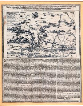
Höchst, On
20.06.1622The painting shows landscape near Höchst and Frankfurt. The Nieda river joins Main near Höchst. On the left, there is the ongoing battle, the defeated army of Christian Brunswick retreats over the bridge over Main. Large column of imperial forces is approaching from Frankfurt. In the left corner of the sheet, there is an A-K legend and on the bottom, there is a German text, describing the course of battle in detail and all relevant facts.
Signature: Not available
Autor: Unknown
Original name: Wahrer und gewisser Bericht sambt Abbildung welcher Gestalt Herzog Christian zu Braunschweig das Churf: Maintzische Stättlin Höchst eingenommen auch wie dessen Armada von den sämbtlichen Kayserlichen Armeen den 20. Juni N.C. oder 10. A.C. dieses lauffenden 1622 Jahrs bey Höchst geschlagen und zerstreut worden. Gedruckt im Jahr 1622
Katalogová čísla: Collection Český Šternberk, kód: 68/160
The second part of the Thirty Years' War was the Palatine war. It followed after the defeat of the Bohemian Revolt on the White Mountain in 1620. Imperial, Bavarian and Spanish armies stood on one side and they were resisted by armies of several German Protestant nobles, who relied mostly upon the financial aid of the English king James I, who supported the interests of his son-in-law, Frederick V, Elector Palatine, with substantial sums of money. These were: Ernst von Mansfeld, field marshal of the “Winter King”, Georg Friedrich, Margrave of Baden-Durlach and Christian, Duke of Brunswick-Wolfenbüttel, who, with his army, stood on the right shore of Main under Frankfurt. Near the town of Höchst, the units of Duke of Brunswick built a bridge over Main, so that they could join the Mansfeld's army, which laid nearby on the other shore. However, when Tilly's army, which wanted to defend Frankfurt, appeared, the Duke of Brunswick and his army fought back. Tilly's forces had superior numbers and they had more artillery. The tactical situation of the Protestant army was bad – for case of retreat, there was nothing but one, quickly built bridge over Main. The battle was not a typical field battle; it was an unclear clash of forces near the town of Höchst and villages named Schäferberg and Sossenheim. Christian Brunswick was being constantly pushed to retreat by the bigger Catholic army and consistent artillery fire. However, the Protestant army lost the most men while retreating. Many men drowned in Main during the confused retreat. A confused crowd of retreating units, which did not manage to cross to the other shore in time, assembled at the bridge in Höchst. The formations of Christian Brunswick resisted heroically, but the result of combat could not be changed any more. Christian Brunswick had achieved his tactical plan to join his and Mansfeld troops, but it cost him 2 000 men. The Catholics probably lost only a little over 100 men.
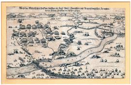
On
20.06.1622The print shows the battle of Höchst on 20 June 1622. The defeated army of Duke of Brunswick retreats over the bridge over Main. In the right upper side, there are cities of Frankfurt, Steinheim and Offenbach, on the left, the course of battle under number of hills is depicted; the river Nieda flows through the middle of the landscape.
Signature: Not available
Autor: Unknown
Original name: Abrisz des ritterlichen Treffens zwischen der Keys: Bayr: Spanischen und Braunschweigischen Armaden darinen Hertzog Christian den kürtzeren gezogen.
Katalogová čísla: Collection Český Šternberk, kód: 69/173
The second part of the Thirty Years' War was the Palatine war. It followed after the defeat of the Bohemian Revolt on the White Mountain in 1620. Imperial, Bavarian and Spanish armies stood on one side and they were resisted by armies of several German Protestant nobles, who relied mostly upon the financial aid of the English king James I, who supported the interests of his son-in-law, Frederick V, Elector Palatine, with substantial sums of money. These were: Ernst von Mansfeld, field marshal of the “Winter King”, Georg Friedrich, Margrave of Baden-Durlach and Christian, Duke of Brunswick-Wolfenbüttel, who, with his army, stood on the right shore of Main under Frankfurt. Near the town of Höchst, the units of Duke of Brunswick built a bridge over Main, so that they could join the Mansfeld's army, which laid nearby on the other shore. However, when Tilly's army, which wanted to defend Frankfurt, appeared, the Duke of Brunswick and his army fought back. Tilly's forces had superior numbers and they had more artillery. The tactical situation of the Protestant army was bad – for case of retreat, there was nothing but one, quickly built bridge over Main. The battle was not a typical field battle; it was an unclear clash of forces near the town of Höchst and villages named Schäferberg and Sossenheim. Christian Brunswick was being constantly pushed to retreat by the bigger Catholic army and consistent artillery fire. However, the Protestant army lost the most men while retreating. Many men drowned in Main during the confused retreat. A confused crowd of retreating units, which did not manage to cross to the other shore in time, assembled at the bridge in Höchst. The formations of Christian Brunswick resisted heroically, but the result of combat could not be changed any more. Christian Brunswick had achieved his tactical plan to join his and Mansfeld troops, but it cost him 2 000 men. The Catholics probably lost only a little over 100 men.
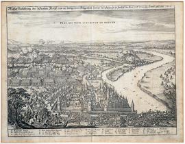
Höchst, On
20.06.1622The town of Höchst is in front of us, on the right, there is a wide river, Main, over which the armies of Duke of Brunswick are fleeing; behind the town, the battle is in full progress yet. Fitting perspective and perfect engraving technique reminds of Václav Hollar. However, the engraving is not signed. Under the pictorial part of the print, there is an A–Z legend.
Signature: Not available
Autor: Unknown
Original name: Wahre Vorbildung des Stettleins Höcchst und der beiliegenden Gelegenheit sampt der Schlacht so zwischen der Kays: und Braunsch: Armee geschehe 1622.
Katalogová čísla: Collection Český Šternberk, kód: 70/149
The second part of the Thirty Years' War was the Palatine war. It followed after the defeat of the Bohemian Revolt on the White Mountain in 1620. Imperial, Bavarian and Spanish armies stood on one side and they were resisted by armies of several German Protestant nobles, who relied mostly upon the financial aid of the English king James I, who supported the interests of his son-in-law, Frederick V, Elector Palatine, with substantial sums of money. These were: Ernst von Mansfeld, field marshal of the “Winter King”, Georg Friedrich, Margrave of Baden-Durlach and Christian, Duke of Brunswick-Wolfenbüttel, who, with his army, stood on the right shore of Main under Frankfurt. Near the town of Höchst, the units of Duke of Brunswick built a bridge over Main, so that they could join the Mansfeld's army, which laid nearby on the other shore. However, when Tilly's army, which wanted to defend Frankfurt, appeared, the Duke of Brunswick and his army fought back. Tilly's forces had superior numbers and they had more artillery. The tactical situation of the Protestant army was bad – for case of retreat, there was nothing but one, quickly built bridge over Main. The battle was not a typical field battle; it was an unclear clash of forces near the town of Höchst and villages named Schäferberg and Sossenheim. Christian Brunswick was being constantly pushed to retreat by the bigger Catholic army and consistent artillery fire. However, the Protestant army lost the most men while retreating. Many men drowned in Main during the confused retreat. A confused crowd of retreating units, which did not manage to cross to the other shore in time, assembled at the bridge in Höchst. The formations of Christian Brunswick resisted heroically, but the result of combat could not be changed any more. Christian Brunswick had achieved his tactical plan to join his and Mansfeld troops, but it cost him 2 000 men. The Catholics probably lost only a little over 100 men.
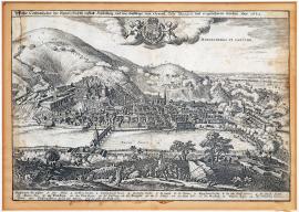
On
21.06.1622 (do 06.09.1622)The town of Heidelberg is situated under a high hill, there is an elector castle on the left, a bridge over the river Neckar at the bottom, the army of Tilly is wading through the Neckar on the right side. In the foreground, there are approaching attacking columns. The city is besieged from all sides and combat actions are everywhere. On a cloud in the sky, there is the Palatine Elector coat of arms that is held by two angels and the inscription: 'Haydelberga capitur'. There are explanatory notes 1 – 20 below. Around the coat of arms, there is a ribbon with the inscription: 'Houi soi qui mal y pense.' It is the motto of the English Order of the Garter whose bearer was the Frederick V, Elector Palatine as a son-in-law of James I of England.
Signature: Not available
Autor: Unknown
Original name: Wahre Contrafactur der Churfürstlichen Statt Heidelberg, und wie dieselbige von General Tilly belägert und eigenommen worden. Anno 1622.
Katalogová čísla: Collection Český Šternberk, kód: 78/162
Just after the battle of Hochst on 20. June 1622, during which the Christian the younger of Brunswick, also called “of Halberstadt', succumbed to Tilly, who had besieged Heidelberg, the capital of the Lower Palatine, on 21 June and already conquered on 6 September. Heidelberg was the capital of the Rhinish (Lower) Palatine and the seat of the elector. The defeat of Frederick V, Elector Palatinate was completed by the conquest of the seat.
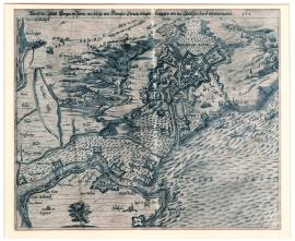
Bergen op Zoom, On
18.07.1622 (do 27.08.1622)The city of Bergen op Zoom is depicted from above, from the so-called bird's-eye view. In the surroundings, there are various Spanish battle structures, which served for approaching and storming the city. The town of Sternbergen is foreshadowed in the upper left part. Probably artificially created floods of the river Scheldt, which were supposed to be an impassable obstacle for any enemies, are extraordinary. Above the painting, there is the mentioned text.
Signature: Not available
Autor: Unknown
Original name: Abrisz der Statt Bergen op Zoom, wie solche von Marquis Spinola belägert, hingegen von Stadtischen starck defendirt worden. 1622.
Katalogová čísla: Collection Český Šternberk, kód: 74/190
Spain – as a Catholic great power under the reign of Spanish side of the House of Habsburg – was an ally of the Habsburg monarchy in the battle against Frederick V, Elector Palatine and his allies. Apart from the war in the empire, another war erupted in the Netherlands. Calvinist Netherlands supported anti-Catholic forces in the empire. The siege of Bergen op Zoom by armies of general Ambrogio Spinola, 1st Marquis of the Balbases from 18 July to 2 August 1622 was a part of this conflict between Spain and the Netherlands. However, the Battle of Fleurus on 29 August 1622 had put everything into motion. The Protestant army, lead by Mansfeld and Christian Brunswick, managed to fight through to the Netherlands, even though they suffered heavy losses, and they joined the Dutch army of Maurice, Prince of Orange. Spinola's siege of Bergen op Zoom was not safe any more, and thus he had to terminate the siege. Christian Brunswick lost an arm in this battle.
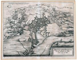
Bergen op Zoom, On
18.07.1622 (do 27.08.1622)The fortified city of Bergen op Zoom is in the centre of the painting. The land around the city shows chances of besieging Spaniards, camps, tents, positions of military units, marching regiment and several banners. The river Scheldt is swollen around the city. There is a Latin inscription above: „Delineatio urbis Bergenobsooma una cum hispanorum castris ad illam factis, anno 1622.“ German text is under the painting on the right. On the left, there is a writing on the water: „Verdroncken Landt – i.e. flooded ground“. To fortify the city, his surroundings were flooded.
Signature: Not available
Autor: Unknown
Original name: Abrisz der Statt Bergen op Zoom sampt dem spänischen Läger im Jahr 1622.
Katalogová čísla: Collection Český Šternberk, kód: 75/204
Spain – as a Catholic great power under the reign of Spanish side of the House of Habsburg – was an ally of the Habsburg monarchy in the battle against Frederick V, Elector Palatine and his allies. Apart from the war in the empire, another war erupted in the Netherlands. Calvinist Netherlands supported anti-Catholic forces in the empire. The siege of Bergen op Zoom by armies of general Ambrogio Spinola, 1st Marquis of the Balbases from 18 July to 2 August 1622 was a part of this conflict between Spain and the Netherlands. However, the Battle of Fleurus on 29 August 1622 had put everything into motion. The Protestant army, lead by Mansfeld and Christian Brunswick, managed to fight through to the Netherlands, even though they suffered heavy losses, and they joined the Dutch army of Maurice, Prince of Orange. Spinola's siege of Bergen op Zoom was not safe any more, and thus he had to terminate the siege. Christian Brunswick lost an arm in this battle.
Rheindorf, On
25.07.1622Wide Rhein river flows through the centre of the painting, we can see the heavily fortified island of Pfaffenmütz. Two ships sail on Rhein. Lower on the Rhein, there is a village of Rindorb (Rheindorf), Berchen is on the upper left. In the right upper corner of the painting, there is a legend with letters A–H. Above the painting, there is the mentioned text, below the painting, there is a four verse long German poem which describes the course of the siege.
Signature: Not available
Autor: Unknown
Original name: Wahrer und eigentlicher Abrisz der starcken Vestung Pfaffenmütz, welche von ihrer Fürstl: Durchl: Newburgerischer Armata zu beyden Seiten des Reyhns, wie auch zu Wasser belägert wordem, im Jahr 1622 den 25. Julij. Gedruckt im Jahr 1622.
Katalogová čísla: Collection Český Šternberk, kód: 71/114
In the second part of the Thirty Years' War, the battles moved from Bohemia to Palatinate. At that time, Dutchmen, who were Calvinists and supported Frederick V, Elector Palatinate, had taken the Rhineland island of Pfaffenmütz near Bonn. Soon after Battle of Höchst, where the army of Christian Brunswick–Wolfenbüttel was defeated by general Tilly on 10 June 1622, the island fortress of Pfaffenmütz was besieged by Neuburg and (according to this engraving) Spanish armies on 25 July 1622. Neuburg is a city on Danube, approximately 25 km to the west from Ingolstadt and the capital of so-called Neuburg Palatinate, whose rulers were relatives of Frederick V, Elector Palatine, but who stood on the side of Maxmilian I, Elector of Bavaria and his Catholic league. The Spanish forces were lead by general Hendrik van den Bergh.
Pfaffenmütz, On
25.07.1622The small painting portrays the fortified island of Pfaffenmütz in the middle of Rhein. In front of us, there is the village of Graen Rhindorf (correctly Gross-Rheindorf). Small stream Sieg joins Rhein. On the left side, in landscape covered in trees, there is a settlement called Berchen.
Signature: Not available
Autor: Unknown
Original name: Abbildung der holländischen Schantz Pfaffenmütz zwischen Köln und Bonn im Rhein erbowen. Anno 1622.
Katalogová čísla: Collection Český Šternberk, kód: 72/220
In the second part of the Thirty Years' War, the battles moved from Bohemia to Palatinate. At that time, Dutchmen, who were Calvinists and supported Frederick V, Elector Palatinate, had taken the Rhineland island of Pfaffenmütz near Bonn. Soon after Battle of Höchst, where the army of Christian Brunswick–Wolfenbüttel was defeated by general Tilly on 10 June 1622, the island fortress of Pfaffenmütz was besieged by Neuburg and (according to this engraving) Spanish armies on 25 July 1622. Neuburg is a city on Danube, approximately 25 km to the west from Ingolstadt and the capital of so-called Neuburg Palatinate, whose rulers were relatives of Frederick V, Elector Palatine, but who stood on the side of Maxmilian I, Elector of Bavaria and his Catholic league. The Spanish forces were lead by general Hendrik van den Bergh.
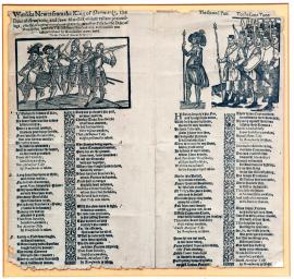
On
06.08.1622There is a small wood carving on every side of the sheet. The left one portrays drummer, flautist and 4 pikemen. The right one shows a commander leading his army. Under the painting, in two columns, there are verses of a song, which ironically describes the Duke of Brunswick and his heroism. Every verse ends with refrain: “Lord Tilly was captured by Brunswick!”
Signature: Vytisknuto v Londýně Janem Trundlerem.
Autor: Trundle John, vydavatel letáků v Londýně
Original name: Warlike Newes from the king of Denmark, the duke of Brunswicke, and count Mansfield, of their valiant proceedings; chiefly of a great ouerthrow given to monsieur Tilly by the doke of Brunswicke, wherein Tilly lost foure thousend men, and himselfe was taken prisoner by Brunswickes own hand. To the tune of Haue at the spaniard.
Katalogová čísla: Collection Český Šternberk, kód: 73/69
It is a very interesting, unknown and surely a rare sheet, which ironically describes the military failures of Mansfeld, Brunswick and Dutch king against Tilly. While fighting the mentioned commanders, Tilly suffered only one, completely meaningless, defeat by Mansfeld at Wiesloch near Mingolsheim on 27 April 1622. However, Brunswick had never defeated Tilly, but he himself was defeated near Höchst (20 June 1622) and near Stadtlohn (6 August 1623), so Tilly could hardly ever be “personally captured by Brunswick”. This lampoon is interesting, because it was published in England; in a country, which supported Frederick V, Elector Palatine, for whom the 3 mentioned commanders (which are mocked in the pamphlet) fought. The English king James was a father-in-law of Frederick and he supported the Protestants, especially financially.
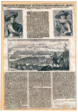
mezi Fleurus a Gembloux, On
29.08.1622The mentioned Dutch text is at the upper side of the sheet. Portraits of Ernst von Mansfeld and Christian Brunswick are below. They both have large hats and marshal batons. The portraits have dimensions 6 x 9.5 cm and they were engraved by S. de Passe. The lower half of the sheet contains a painting of the actual battle. In the right front, there are riders with banners with dead horse nearby. The main scene of the painting is the cavalry attack lead by Duke of Brunswick, who decided the battle in his and Mansfeld's favour by this decisive attack of his. At the horizon, town of Flory is on the left and town of Gemblours is on the right. Under the painting, there is an extensive Dutch text concerning the course of the battle.
Signature: Rytina tištěna v tiskárně Jana Amelissza v Utrechtu.
Autor: Zeidlerus Andreas, poručík, kreslíř map a plánů
Original name: Waerachtighe Af-Conterfeytinghe vanden grooten slach, gheschiet tusschen die van Manveld ende Brunns-wijcksche aen d´eene zijde ende Don Cordova aen d´ander zijde: Opden 29. August 1622 Tusschen Gembeloers ende Flory.
Katalogová čísla: Collection Český Šternberk, kód: 76/2
Rhenish Palatinate, hereditary region of Frederick V, Elector Palatine, the symbol of resistance against the Catholic power of the emperor, was the main theatre of fights between 1620 and 1623. General Johann Tserclaes Tilly lead the imperial armies of the League. Protestant armies, which were mainly supported from England, because the English king James I was a father-in-law of Frederick, consisted mostly of the army of Ernst von Mansfeld and of units of Christian, Duke of Brunswick-Wolfenbüttel, who entered the war side by side with the “Winter king”, because of knight's honour to his wife, queen Elisabeth, whom he loved. Christian, Duke of Brunswick-Wolfenbüttel was also being called “Halberstadt” after a cloister of the same name, whose foundation he administered. After various tactical movements and small, insignificant fights, prior to the joining of Mansfeld's and Brunswick's units, Christian Halberstadt suffered a crushing defeat near Höchst upon Main on 20 June 1622. This combat failure of Protestants changed the balance of power so significantly that Frederick V, Elector Palatine started to think about some settlement with the emperor and he had released Mansfeld and Christian Brunswick from his services because of this settlement. However, Christian Brunswick and Mansfeld had kept their forces, joined into one strong army and searched for more military adventures, which they soon found in connection with so-called general countries of the united Netherlands. They immediately withdrew to liberate Bergen op Zoom, which was under siege by Spaniards lead by Ambrogio Spinola, 1st Marquis of the Balbases. General Cordoba with his army intended to prevent the liberation, and the battle this print shows occurred. Spanish general was able to inflict great losses on the Protestant army, but he was not able to prevent them from entering the Netherlands. Spinola was then forced to withdraw from Bergen op Zoom. However, the Dutch soon felt unbearable economic stress which was caused by armies from Germany; Mansfeld and Brunswick were forced to part ways and search for new adventures, which they were able to find very soon in these turbulent times.
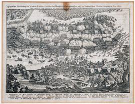
Fleurus, On
29.08.1622The engraving shows the battle of Fleury on 29 August 1622. In the front, we see Mansfeld's retreating army, in the middle, the fight is in full progress. On the left, there is a depiction of an attack of cavalry of Duke Christian of Brunswick, who, even though he was wounded on arm, had decided this battle in his favour, because it was a draw for a long time and Mansfeld's units were already partially retreating. In the end, Spaniards were defeated. The horizon of the landscape is a forest. In the front of us on the right, there are three fleeing musketeers of Mansfeld. Under the painting, there is an A–N legend.
Signature: Not available
Autor: Unknown
Original name: Eigentliche Vorbildung des harten Treffens so zwischen Mansfeldischen und Spanischen auff den Brabändischen Grentzen vorgangen, Anno 1622. Praelium inter Hispanos et Mansfeldicos ad Floreacum in Brabantia.
Katalogová čísla: Collection Český Šternberk, kód: 77/146
Rhenish Palatinate, hereditary region of Frederick V, Elector Palatine, the symbol of resistance against the Catholic power of the emperor, was the main theatre of fights between 1620 and 1623. General Johann Tserclaes Tilly lead the imperial armies of the League. Protestant armies, which were mainly supported from England, because the English king James I was a father-in-law of Frederick, consisted mostly of the army of Ernst von Mansfeld and of units of Christian, Duke of Brunswick-Wolfenbüttel, who entered the war side by side with the “Winter king”, because of knight's honour to his wife, queen Elisabeth, whom he loved. Christian, Duke of Brunswick-Wolfenbüttel was also being called “Halberstadt” after a cloister of the same name, whose foundation he administered. After various tactical movements and small, insignificant fights, prior to the joining of Mansfeld's and Brunswick's units, Christian Halberstadt suffered a crushing defeat near Höchst upon Main on 20 June 1622. This combat failure of Protestants changed the balance of power so significantly that Frederick V, Elector Palatine started to think about some settlement with the emperor and he had released Mansfeld and Christian Brunswick from his services because of this settlement. However, Christian Brunswick and Mansfeld had kept their forces, joined into one strong army and searched for more military adventures, which they soon found in connection with so-called general countries of the united Netherlands. They immediately withdrew to liberate Bergen op Zoom, which was under siege by Spaniards lead by Ambrogio Spinola, 1st Marquis of the Balbases. General Cordoba with his army intended to prevent the liberation, and the battle this print shows occurred. Spanish general was able to inflict great losses on the Protestant army, but he was not able to prevent them from entering the Netherlands. Spinola was then forced to withdraw from Bergen op Zoom. However, the Dutch soon felt unbearable economic stress which was caused by armies from Germany; Mansfeld and Brunswick were forced to part ways and search for new adventures, which they were able to find very soon in these turbulent times.
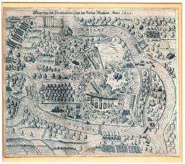
Mannheim, On
11.09.1622 (do 23.10.1622)This is a schematic plan of the town of Mannheim with the river Rhine into which the Neckar flows. The landscape is studded with trees, which are all equally carved. The fortress of Mannheim is drawn without the construction details, just fortified facilities are carefully drawn up. Around the area, there are scattered individual soldiers and lines of shooting musketeers.
Signature: Not available
Autor: Unknown
Original name: Belägerung und Einnehmung der Statt und Vestung Mannheim. Anno 1622.
Katalogová čísla: Collection Český Šternberk, kód: 79/209
After the defeat of the Protestant allies of Frederick V, Elector Palatinate in the Battle of Hochst (20 June, 1622), and Wimpfen (6 May 1622), Tilly continued in the conquest of the entire Lower Palatine, the inherited land of Frederick V, Elector Palatinate. He captured the capital city of Heidelberg on 6 September 1622. At the same time, the fortress of Mannheim was besieged and conquered; it finally surrendered to Tilly on 23 October 1622.
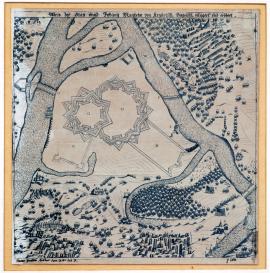
Mannheim, On
11.09.1622 (do 23.10.1622)In the middle of the image, there is a schematic drawing of the fortress of Mannheim with the rivers Rhine and Neckar. In the surroundings of the city, there are deployed cannons and many trees with spherical treetops. Explanatory notes A-T under the image are missing (cut off).
Signature: Not available
Autor: Unknown
Original name: Abrisz der Statt und Vestuung Mannheim von Kayserisch, Bayrisch belägert und erobert.
Katalogová čísla: Collection Český Šternberk, kód: 79a/480
After the defeat of the Protestant allies of Frederick V, Elector Palatinate in the Battle of Hochst (20 June, 1622), and Wimpfen (6 May 1622), Tilly continued in the conquest of the entire Lower Palatine, the inherited land of Frederick V, Elector Palatinate. He captured the capital city of Heidelberg on 6 September 1622. At the same time, the fortress of Mannheim was besieged and conquered; it finally surrendered to Tilly on 23 October 1622.
London, On
01.01.1623 (do 31.12.1623)The image is divided into 4 parts: 1. The scene in the Catholic Church; the King is sitting in an armchair with several courtiers around him; the priest is reading from the book of marital conditions at the altar. 2. The King at the ceremony feast; the King is washing his hands in the foreground. 3. The parade which is led by the King. 4. Remote view on London (“Lunden”) with the River Thames.
Signature: Not available
Autor: Unknown
Original name: Abilltung wie königliche Majestät in Engelandt die Artickel desz spanischen Heyraths Iur. bekräftiget. Anno 1623.
Katalogová čísla: Collection Český Šternberk, kód: 88/210
King James I of England, the first of the House of Stuart, was the son of Mary, Queen of Scots, and was born on 10 June 1566, entered the matrimony with Anne of Denmark on 24 November 1589, was enthroned on the English throne in 1603 and died on 27 March 1625. His reign is considered unsuccessful, because he was in constant conflict with the Parliament over religious issues in the country as a result of his obstinate character. One of his unfortunate ideas was an arrangement of a marriage of his son Charles with the Princess of Spain which is the subject of this graphic. Judging by the press, the King's idea had already become real in 1623, when the marital conditions were officially negotiated in London. However, the wedding did not happen. England and Spain were permanent opponents in wars during the 17th century, furthermore, the Spanish Royal family was an anathema to the Catholic majority of the English Parliament. This situation no doubt prevented the King's intention of marriage from happening. James I was the father-in-law of Frederick V, Elector Palatinate, nicknamed the Winter King of Bohemia, whom James I also had heavily supported since the beginning of the Thirty Years' War. His successor was his son Charles I, who was born on 19 September 1600, married to Henrietta Maria of France, sister of Louis XIII, and executed on 30 January 1649 during the Oliver Cromwell’s revolution.
Friedland, On
16.07.1623Engraving is drawn quite incompetently. In the foreground, there is the Friedland Castle in Göttingen and the town of Rüstenberg in the background. On the left side, there is a number of Brunswick troops’ camps and the encounter of the cavalry is in the middle. Various units of troops are scattered throughout the surroundings. In the background, there is a camp of the imperial troops under the Rüstenberg Castle.
Signature: Not available
Autor: Unknown
Original name: Abrisz des Braunschweigischen Schloss Friedland von Graff Tilly eingenommen, und wie solches zu entsetzen Herzog Christian sich vergebens unterstanden.
Katalogová čísla: Collection Český Šternberk, kód: 83/92
As soon as the Palatine phase of war ended by the complete defeat of Frederick V, Elector Palatinate, and his Electoral rank was removed and transferred to Maximilian I. of Bavaria, it was crucial to solve the complex political situation in Lower Saxony. The situation in this country was absolutely unclear, because Christian, the Duke of Brunswick, had exposed himself militarily on the side of the Emperor's opponents, and then he stood with his army, which had been recruited, similarly as Mansfeld, against the Emperor, in the Lower Saxon. The King Christian IV of Denmark had a certain influence here. The Emperor negotiated with the Duke of Brunswick – Halberstadt, who, however, significantly prolonged the negotiations, because he intended to strengthen his army in the meantime. Tilly apparently revealed the cunning intentions of the Duke of Halberstadt and invaded into Göttingen and despite Brunswick’s resistance; he conquered the castle of Friedland. At the same time, Tilly said that he would leave Friedland only if Halberstadt dissolved his armies and submitted to the overall policy of the Lower-Saxon. However, Halberstadt could not be forced to this, because in the meantime, the Duke Julius Ernest of Saxe-Lauenburg, serving under Tilly, was defeated by Halberstadt in the attempt to conquest the castle of Plesse, and then he even freed the Friedland.
Friedland, On
16.07.1623On the engraving, the story of the battle is quite primitively drawn. On the hill, there is the castle of Friedland and in its neighborhood, there are many military divisions, shooting cannons, camps, fortification system and several villages. A comprehensive inscription above can be found below the printed images, it is followed by a German text which is divided into three columns, as well as the explanatory notes A-Z and 1-10.
Signature: Franckfort bey Eberhard Kiesern.
Autor: Kleser Eberhard, nakladatel ve Frankfurtu nad Mohanem
Original name: Wahrhafftige und eigentliche Beschreibung auch Abrisz desz Castells und Schlosses Friedland, welches mit zwo Compagnien Dragonern besetzt gewesen und von dem hoch wohlgebornen Graffen und Herrn Herrn Generalen Tilly, den 16. Juli, dieses jetzt laufenden 1623 Jahres ausz 6 halben Carthaunen mit 214 Schüssen zur Bresche und Sturm geschossen, darauf die Besatzung sich ergeben aber ihre Oberwehr und Pferd derer in die 200 gewesen im Stich lassen müssen viel Proviant und Munition erobert neben Versprechung dass sie in 5 Monaten wider die Catholischen nit dienen wollten.
Katalogová čísla: Collection Český Šternberk, kód: 84/300
As soon as the Palatine phase of war had ended by the complete defeat of Frederick V, Elector Palatinate, and his Electoral rank had been removed and transferred to Maximilian I. of Bavaria, it was crucial to solve the complex political situation in Lower Saxony. The situation in this country was absolutely unclear, because Christian, the Duke of Brunswick, had exposed himself militarily on the side of the Emperor's opponents, and then he stood with his army, which had been recruited, similarly as Mansfeld, against the Emperor, in the Lower Saxon. The King Christian IV of Denmark. The Emperor negotiated with the Duke of Brunswick – Halberstadt, who however significantly prolonged the negotiations, because he intended to strengthen his army in the meantime. Tilly, however, apparently revealed the cunning intentions of the Duke of Halberstadt, invaded into Göttingen and despite Brunswick’s resistance, he conquered the castle of Friedland. At the same time Tilly said that he would leave Friedland only if Halberstadt would dissolve his armies and submit to the overall policy of the Lower-Saxon. However, Halberstadt could not be forced to this, because in the meantime, the Duke Julius Ernest of Saxe-Lauenburg, serving under Tilly, had been defeated by Halberstadt in the attempt to conquest the castle of Plesse, and then he even freed the Friedland.
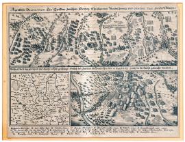
Stadtlohn, On
05.08.1623 (do 06.08.1623)The image is divided into two parts: the upper one shows the retreat and the persecution of the Brunswicks by eight broken ravines by the armies of General Tilly. At the bottom left, there is the situational map of the battlefield, final battle of both armies of Stadtlohn and the defeated Brunswick troops fleeing to the Netherlands. The inscription is above the printed images, there are the explanatory notes A-Z at the bottom.
Signature: Not available
Autor: Unknown
Original name: Aigentliche Delineation des Treffens zwischen Herzog Christian von Braunschweig und General Tilly im Stift Münster, welcher zwen Tag gewehret und durch VIII Päss geschlagen, entlich bei Stadtlon die Braunschw. de VI. August 1623 ganz in die Flucht gebracht worden.
Katalogová čísla: Collection Český Šternberk, kód: 85/171
When the combat finished in Bohemia and later in the Rhinish Palatine as well, the political situation in the Lower-Saxon country remained unclear because of the hesitation between alliances, neutrality or open resistance to the emperor. Long and complex negotiations were led, in which even Christian IV of Denmark participated. The Duke Christian of Brunswick, also called Halberstadt, defeated by Tilly, also participated in the negotiations and meanwhile transferred his troops’ camp from Friesland to the Vézère. Mansfeld, also previously defeated by Tilly, remained in Friesland. After long and fruitless negotiations of all participants, Christian, the Duke of Brunswick, declared that he could no longer be responsible for the ravages of the Lower-Saxon countries by the Emperor’s troops and entered into an open war with the Tilly’s troops, but he retreated, being chased by Tilly from the area east of Steinfurt to Stadtlohn (approx. 60 km), here he was apprehended and forced to fight during which he was devastatingly defeated. The remnants of his scattered army fled to the Netherlands (Stadtlohn is situated near the Dutch border). About 3,000 men with the General Knyphausen and younger Count Thurn fled. The Duke of Saxe-Weimar, Frederick of Saxe-Altenburg and the Count von Schlick were captured. Mansfeld passively observed the disaster of his allies. The battle events, described here, occurred about 70 kilometers north of the Ruhr area.
Münsterské biskupství, On
06.08.1623The artwork is quite primitive. Throughout the area, there are scattered the square infantry and cavalry regiments, which were partly fighting. On the upper left, there is portrayed the scene in front of the command tent in the presence of the cavalry and infantry regiment with many flags and banners. Next to this one, there is a portrait of Christian Halberstadt with a probably ridiculed face on a circular field. In the middle of the image, there is the inscription 'Statlo', i.e. the name of the town Stadtlohn; the town itself, however, is not pictured. It is also remarkable that there is depicted the General Tilly with disproportionately tall and massive body on the right side, while Christian, the Duke of Brunswick, leading his fleeing units, is pictured vanishingly small on the left side. The author without any doubt wanted to express the disparity of their skills as military leaders by the disproportioned size of both generals.
Signature: Not available
Autor: Unknown
Original name: Wahre und eigentliche Abbildung wes massen Hertzog Christian v. Braunschweig armada den 6. August 1623 im Stifft Münster aufs Haupt erlegt.
Katalogová čísla: Collection Český Šternberk, kód: 86/201
When the combat finished in Bohemia and later in the Rhinish Palatine as well, the political situation in the Lower-Saxon country remained unclear because of the hesitation between alliances, neutrality or open resistance to the emperor. Long and complex negotiations were led, in which even Christian IV. of Denmark participated. The Duke Christian of Brunswick, also called Halberstadt, defeated by Tilly, also participated in the negotiations and meanwhile transferred his troops’ camp from Friesland to the Vézère. Mansfeld, also previously defeated by Tilly, remained in Friesland. After long and fruitless negotiations of all participants, Christian, the Duke of Brunswick, declared that he could no longer be responsible for the ravages of the Lower-Saxon countries by the Emperor’s troops and entered into an open war with the Tilly’s troops, but he retreated, being chased by Tilly from the area east of Steinfurt to Stadtlohn (approx. 60 km), here he was apprehended and forced to fight during which he was devastatingly defeated. The remnants of his scattered army fled to the Netherlands (Stadtlohn is situated near the Dutch border). About 3,000 men with the General Knyphausen and younger Count Thurn fled. The Duke of Saxe-Weimar, Frederick of Saxe-Altenburg and the Count von Schlick were captured. Mansfeld passively observed the disaster of his allies. The battle events, described here, occurred about 70 kilometers north of the Ruhr area.
Lippe, On
02.11.1623The town is illustrated in perspective from above. The troops of Brunswick retreat by crossing the bridge over the river Lippe. Around the town, there are fortification systems and defensive bastions from which it is possible to shoot. Four military troops in square positions are located nearby the town. In the background, there are several ponds. The individual troops are marked by inscriptions.
Signature: Not available
Autor: Unknown
Original name: Abrisz der Belägerung der Statt Lippe und wie solche den 2. Novembris mit Accord Kön: May: in Spanien ist Übergeben worden. Anno 1623.
Katalogová čísla: Collection Český Šternberk, kód: 87/181
After the defeat of Christian, the Duke of Brunswick – Halberstadt, by General Tilly in the Battle of Stadtlohn on 6 August 1623, and even some other places in the County of Lippe, which used to be occupied by Brunswick since June 1623, when he had broken up with Lower-Saxon countries, were conquered. Among these places, there was also the town of Lippe, which was conquered on the basis of agreement by the Spaniards who were led by the Marquess Spinola on 2 November 1623. Brunswick garrisons withdrew. Lippe is approximately 60 to 70 km southwest from Hannover.
Velaw, On
01.01.1624 (do 31.12.1624)The image is divided into four parts: There are three separate scenes, i.e. the attack of cavalry, the expulsion of robbed inhabitants from their homes and plundering of farmhouses. At the bottom, there is illustrated the march of the Dutch defenders against the enemy, guns in fire positions, marching infantry and construction of fortifications; several wagons with the fleeing civil populations meet the approaching Dutch army halfway. It is remarkable that the sleighs (snow is rare in the Netherlands) are dispersed among all the wagons; It's probably some sort of sliding wagons, which were effective on the Dutch sand. The artwork has a typical style of Dutch painters á la Brueghel, etc.
Signature: Not available
Autor: Unknown
Original name: Eynfall des Grafen Heinrich von dem Berg in die Velawe im Jahr 1624. Der Holländer Anzug wider ihre Feindt 1624.
Katalogová čísla: Collection Český Šternberk, kód: 89/195
The Netherlands happened to be in war with Spain in 1621, which lasted long time, after the expiry of the truce. Even the imperial troops participated in this campaign alongside the Spaniards, because the Netherlands was an ally and supporter of Frederick V, Elector Palatinate. The Commander of these troops was Count Henry I of Berg, who fought in the service of Infanta Isabella, daughter of Philip II of Spain and the wife (now widow) of Albert VII, Archduke of Austria, who was the ruler of the separate Habsburg Netherlands (now Belgium) until 1622.
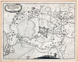
Breda, On
24.08.1624 (do 05.06.1625)The image depicts a rather schematic map of the area around the fortress of Breda, which is displayed in the centre of the sheet. There are extensive fortifications around it and the sea on the left side. The surrounding landscape is heavily covered by individual trees. In the foreground, there are two musketeers and the cavalry is nearby. The Latin inscription above is on the decorative cartouche on the left side.
Signature: Not available
Autor: Unknown
Original name: Breda obsessa et expugnata armiis Philippi IV., regis Hispaniae etc Ducatu Isabellae Clarae Eugeniae Hisp. infantis Virtute Ambrosio Spinolae etc. Annis 1624 et 25.
Katalogová čísla: Collection Český Šternberk, kód: 90/152
Spain was constantly in the state of war with the Netherlands, which was interrupted by a truce from 1609 until 1621. Then Spain was involved in the Bohemian-Palatine phase of war and fought again against the Netherlands as an ally of the Emperor. The Commander of the Spaniards was the Marquis Spinola, who turned against the States General (i.e. of the Netherlands) after defeating Frederick V, Elector Palatinate, and his allies. In this campaign, he fought against Maurice, Prince of Orange, whose father was William I, Prince of Orange, who launched an armed resistance against Spain and also sieged the town of Breda. It is located approximately 50 km south from Rotterdam in Flanders, or rather, in the territory of dukedom of Infanta Isabella Clara, the widow of Albert VII, Archduke of Austria. For the same reason, it is given in the above cited Latin text. Breda resisted the Spanish siege since 24 August 1624 to 5 June 1625, when it was finally conquered.
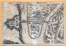
soutok Labe s Muldy, On
15.04.1626In the middle of the image, the confluence of Mulda and Elbe is illustrated. On the left bank of the Elbe, there is the imperial wall, a bridge behind it and a dam over the peninsula to Mulda, which is crossed by a bridge again. The whole landscape is heavily covered with individual trees. The town of Dessau is pictured on the right side of the print. Troops or camps of the troops are not here. Dessau lies approximately 100 kilometers southwest from Berlin.
Signature: Not available
Autor: Unknown
Original name: Abbildung der kayserischen Schantz an der Tessawer Brücken.
Katalogová čísla: Collection Český Šternberk, kód: 91/158
In the second half of the year 1625, Wallenstein led his newly recruited and very large army via Cheb to West Germany, where he, however, did not unite with his wartime partner Tilly (probably for reasons of supply), but after unsuccessful negotiations for a truce with the Duke of Brunswick and Christian IV of Denmark, he went to the middle of Germany. To secure his position at the Dessau bridge, Wallenstein had a bridge across the Elbe and a defensive wall built. When his enemies saw that the construction became dangerous for them, they sent Mansfeld with a reasonably strong army to conquer the fortress of Dessau, and thus made it impossible for Wallenstein to cross the river Elbe. The imperial garrison in the fortress was commanded by Aldringen who successfully repulsed Mansfeld’s attacks, then the defenders’ resistance weakened and Aldringen was forced to call Wallenstein on assistance and he immediately intervened. First, he sent Henry von Schlick with several regiments of cavalry, he came with an infantry himself later on, but still in time to help endangered Aldringen; by his large artillery, he reversed the situation of the battle and prepared an overwhelming defeat to Mansfeld and his troops which never recovered. It was also the last major combat encounter for Mansfeld who then soon disappeared from the scene of the Thirty Years’ War, because he withdrew to Bosnia and suddenly died there in the village of Rakovica. The battle of the Dessau bridge on 15 April 1626.
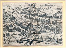
Dessa, On
15.04.1626It is a print without a more detailed textual explanation which depicts the defeated Mansfeld by Wallenstein at the Dessau bridge on 15 April 1626. The engraving is done in detail with many realistic particularities. There is a bridge across the river Elbe, fortress, Mansfeld’s chances and explosion of his ammunition supplies. On the right side we can see the town of Zerbst.
Signature: Not available
Autor: Unknown
Original name: Dessa
Katalogová čísla: Collection Český Šternberk, kód: 92/338
In the second half of the year 1625, Wallenstein led his newly recruited and very large army via Cheb to West Germany, where he, however, did not unite with his wartime partner Tilly (probably for reasons of supply), but after unsuccessful negotiations for a truce with the Duke of Brunswick and Christian IV of Denmark, he went to the middle of Germany. To secure his position at the Dessau bridge, Wallenstein had a bridge across the Elbe and a defensive wall built. When his enemies saw that the construction became dangerous for them, they sent Mansfeld with a reasonably strong army to conquer the fortress of Dessau, and thus made it impossible for Wallenstein to cross the river Elbe. The imperial garrison in the fortress was commanded by Aldringen, who successfully repulsed Mansfeld’s attacks, then the defenders’ resistance weakened and Aldringen was forced to call Wallenstein on assistance and he immediately intervened. First, he sent Henry von Schlick with several regiments of cavalry, he came with an infantry himself later on, but still in time to help endangered Aldringen; by his large artillery, he reversed the situation of the battle and prepared an overwhelming defeat to Mansfeld and his troops which never recovered. It was also the last major combat encounter for Mansfeld who then soon disappeared from the scene of the Thirty Years’ War, because he withdrew to Bosnia and suddenly died there in the village of Rakovica. The battle of the Dessau bridge on 15 April 1626.
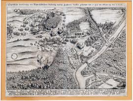
Dessa, On
15.04.1626Heavily forested landscape with the Elbe, into which the river Mulde flows. The battle and fleeing of Mansfeld’s army are displayed on the shore behind the bridge that crosses both rivers. On the left side, there is a compass. Above the image, there is a text, at the bottom, there are the explanatory notes A-Z.
Signature: M. Merian
Autor: Unknown
Original name: Eigentliche Vorbildung der Mansfeldischen Niederlag bey der Tessawer brücken geschehen den 25. Aprilis an S. Marx tag Anno 1626.
Katalogová čísla: Collection Český Šternberk, kód: 93/330
In the second half of the year 1625, Wallenstein led his newly recruited and very large army via Cheb to West Germany, where he, however, did not unite with his wartime partner Tilly (probably for reasons of supply), but after unsuccessful negotiations for a truce with the Duke of Brunswick and Christian IV of Denmark, he went to the middle of Germany. To secure his position at the Dessau bridge, Wallenstein had a bridge across the Elbe and a defensive wall built. When his enemies saw that the construction became dangerous for them, they sent Mansfeld with a reasonably strong army to conquer the fortress of Dessau, and thus made it impossible for Wallenstein to cross the river Elbe. The imperial garrison in the fortress was commanded by Aldringen who successfully repulsed Mansfeld’s attacks, then the defenders’ resistance weakened and Aldringen was forced to call Wallenstein to assist and he immediately intervened. First, he sent Henry von Schlick with several regiments of cavalry, he came with an infantry himself later on, but still in time to help the endangered Aldringen; by his large artillery, he reversed the situation of the battle and prepared an overwhelming defeat of Mansfeld and his troops which never recovered. It was also the last major combat encounter for Mansfeld who then soon disappeared from the scene of the Thirty Years’ War because he withdrew to Bosnia and suddenly died there in the village of Rakovica. The battle of the Dessau bridge on 15 April 1626.
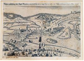
Münden, On
30.05.1626On the engraving, there is the Tilly’s army shooting across the river Vézère, which is crossed by the bridge to the town of Münden. On the other bank of Vézère, there is an additional units’ attack. The background of the image is a forested, hilly panorama, in the right foreground, there is the gallows and a big wheel.
Signature: Not available
Autor: Unknown
Original name: Wahre Abildung der Stadt Münden, wie dieselbe vom kays. Herrn Gen. Gr. Tilly erob. und eingenommen 1626.
Katalogová čísla: Collection Český Šternberk, kód: 94/106
The victory over Mansfeld in the Battle of the Dessau bridge on 25 April 1626, escape and collapse of his army allowed Wallenstein to enter to Silesia and further East to confront raids of Gabriel Bethlen, the Prince of Transylvania, and his allies, who was later on forced to conclude peace with the Emperor. This, however, made everything easier for Tilly as well, whose current adversary was Christian IV of Denmark. Tilly’s campaign against the Danes led to the North, and on 30 May 1626, he conquered the town of Mülden and on 27 August of the same year, he defeated King Christian IV in the great battle of Lutter.
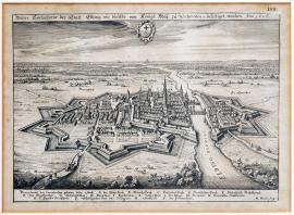
Elbing, On
01.06.1626 (do 30.06.1926)In wide plateau, with the sea in the background, there is the besieged town of Elbing, from which a high church tower protrudes, and it is surrounded by powerful moats. On the right side, the same river runs through the town. Towards the upper edge of the image, there is the emblem of the town. Elbing is located in East Prussia on the sea coast, approximately half the distance between Kaliningrad and Gdynia. Below the image, there are explanatory notes A-S.
Signature: M. Merian fecit.
Autor: Merian Mateus, mědirytec a nakladatel ve Frankfurtu nad Mohanem
Original name: Wahre Contrafactur der Statt Elbing, wie dieselbe von Königl. May. zu Schweden etc. befestigt worden. Anno 1626.
Katalogová čísla: Collection Český Šternberk, kód: 95/161
Before Gustavus Adolphus of Sweden entered into war against the Emperor and Catholics (1630), he fought for a long time against the Polish King Sigismund with whom he then concluded a short-term truce lasting until 1625. However, the war started again and ended in Swedish victory over the Poles, who were commanded by the Prince Lew Sapieha, on 3 January 1626. Then Gustavus Adolphus turned to East Prussia which was a Polish fief, which was given to his brother-in-law George William, Elector of Brandenburg. The Swedes were threatened with annexing this area to Poland. East Prussian towns, however, opened their gates to the Swedes without resistance. These were: Braunsberg, Marienburg and Elbing, whose fortifications were strengthen by Gustavus Adolphus.
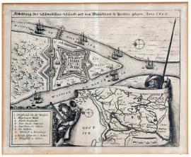
Visla, On
01.07.1626 (do 31.12.1626)The engraving shows the flow of the River Vistula which divides into two. The bridge crosses the river and there are several sailing ships on the surface. On the furthest tip of the peninsula, which is created by both shoulders of the Vistula, is a Swedish fortress with a cleared forest behind it. In the bottom right corner of the image, there are two private soldiers, one with a pike, the other with a musket, holding a map of the area of Lower Vistula River and the Baltic Sea with a visible compass. There is a square with the explanatory notes 1-10 at the bottom left.
Signature: Not available
Autor: Unknown
Original name: Abbildung der Schwedischen Schantz auff dem Weysselstrom in Preussen gelegen 1626.
Katalogová čísla: Collection Český Šternberk, kód: 98/337
During the 1730s, Gustavus Adolphus of Sweden permanently fought with Sigismund III of Poland whom he defeated several times. Then he campaigned against his brother-in-law George William, Elector of Brandenburg, to prevent him from helping the Poles, because Prussia was back then the feudal Duchy of Poland. Several attempts of Poles to free the oppressed town remained unsuccessful. The siege lasted the entire year 1627 and Gustavus Adolphus was wounded twice. Later, he concluded a truce with Poland which was promoted by Imperialists through Wallenstein’s troops. The truce was arranged by France and thus Gustavus Adolphus was free to fight against Anti-Catholics in Germany.
Lutter, On
22.08.1626The engraving shows the situation of the battle between Tilly and the Christian IV of Denmark near Lutter. There are marked the towns of Wolfenbüttel, Lutter, Northeim, Göttingen and Duderstadt. From Lutter to Duderstadt, there flows a stream, which separates the positions of both armies. In the right corner, there is a rectangle with the explanatory notes A-F.
Signature: M. Merian
Autor: Merian Mateus, mědirytec a nakladatel ve Frankfurtu nad Mohanem
Original name: Eigentliche Abbilldung der trefflichen Victori, welche Graf Tilly, Kays: General wider den König in Denemarck 22. August 1626 St. Novo erhalten.
Katalogová čísla: Collection Český Šternberk, kód: 96/172
One of the most important war events of the so called Danish phase of the Thirty Years’ War was the defeat of Christian IV of Denmark at Lutter by the troops of General Tilly on 22 August 1626. The ability of Mansfeld’s army to fight was destroyed by Wallenstein’ victory in the battle of Dassau and Christian IV of Denmark remained on his own against Tilly. He tried to march to better positioning and conquered the Wolfenbüttel on his way, however, he moved his troops so clumsily that his opponent Tilly succeeded in forcing him to battle in an unfavourable strategic situation for the Danes. However, the Danes managed to initially fight the battle equally, almost up to the victory over Tilly. Perfectly led attacks of the Imperial-Wallenstein’s Colonel des Fours reversed the situation in favour of Tilly who eventually reached a significant victory near Lutter. Christian IV of Denmark escaped from the battle with the rest of the defeated army. He lost 3,000 men, 102 officers, 22 cannons, the war treasure, 70 flags and standards and other material. Thanks to this defeat, Christian IV of Denmark lost his significant power position among Protestants which was later taken over by Gustavus Adolphus of Sweden.
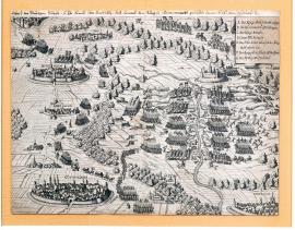
Göttingen, On
22.08.1626There are the towns of Göttingen, Northeim, Sese and Wolfenbüttel in the picture. The main location of the image is the battle between the two armies across the stream. There is the Fort Lutter nearby and the town of Duderstadt at the bottom right. In the upper right corner, there are explanatory notes A-G in the square. The quoted text is written in an antique font above the image of the copperplate.
Signature: Not available
Autor: Unknown
Original name: Abrisz der blutigen Schlacht so Ihr. Excel. herr Graff Tilly, kays. General dem König in Dennemark geliefert Anno 1626 den 22. Augusti.
Katalogová čísla: Collection Český Šternberk, kód: 97/341
One of the most important war events of the so called Danish phase of the Thirty Years’ War was the defeat of Christian IV of Denmark at Lutter by the troops of General Tilly on 22 August 1626. The ability of Mansfeld’s army to fight was destroyed by Wallenstein’ victory in the battle of Dassau and Christian IV of Denmark remained on his own against Tilly. He tried to march to better positioning and conquered the Wolfenbüttel on his way, however, he moved his troops so clumsily that his opponent Tilly succeeded in forcing him to battle in an unfavourable strategic situation for the Danes. However, the Danes managed to initially fight the battle equally, almost up to the victory over Tilly. Perfectly led attacks of the Imperial-Wallenstein’s Colonel des Fours reversed the situation in favour of Tilly who eventually reached a significant victory near Lutter. Christian IV of Denmark escaped from the battle with the rest of the defeated army. He lost 3,000 men, 102 officers, 22 cannons, the war treasure, 70 flags and standards and other material. Thanks to this defeat, Christian IV of Denmark lost his significant power position among Protestants which was later taken over by Gustavus Adolphus of Sweden.
řeka Enns, On
01.12.1626 (do 31.12.1626)Under the above text, many peasant weapons are depicted which were used during the peasant riots in the year 1626 in Upper Austria. It is noteworthy that the depicted weapons also include several Czech Hussite weapons, e.g. „ein böhmischer eiserner Morgenstern“, „ein žiškaischer Streitkolben“ or „ein böhmischer Kornhammer.“ There are even instructions for use for some of the weapons, e.g. the weapons marked A are held by several warriors on long poles; then they run into the groups of enemy horsemen and pull the riders from the horses using large hooks. Under the weapons there are pictures of five peasant chiefs, and one other chief on a horse. The peasant commanders are identified by their names. A two-verse explanation of the picture follows, with anti-peasant tendencies.
Signature: Vytištěno roku 1627
Autor: Unknown
Original name: Glucks-hafen, vor hundert Jahren vorgangenen Bauernkriegs. Sampt eigentlicher Contrafactur und Abrisz der vornehmsten Offizieren und Befehlshabere sowol der gewehr und Waffen derer sich itzo die rebellischen Bauren im Ländlein ob der Ensz in diesem Hier lauffendem 1626 Jahr, bei ihrer vermeynten Kriegsexpedition gebrauchen.
Katalogová čísla: Collection Český Šternberk, kód: 99/72
Even when Ferdinand II. came to the throne, peasant riots took place in his hereditary lands, which were caused by the Emperor's effort to suppress all non-Catholics in the empire. This is because the Protestant faith was much more widespread in the Austrian hereditary lands. But social conditions were also a cause of the riots. The peasants had been suppressed by the nobility, and they tried to free themselves from this situation by using violence. Due to inadequate communication in the difficult mountainous Austrian region, military suppressive actions were significantly hindered and dragged on for several years.
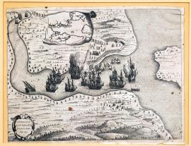
de Todos los Santos, On
01.01.1627 (do 31.12.1627)The etching depicts the harbour of Todos los Santos on the Atlantic coast of Brazil, near San Salvador (Bahia), approximately 1,400 km north of Rio de Janeiro. In the harbour there are several battleships with sails, of which two are in flames. The coast is fortified and occupied by battling troops. On the sea there are several smaller boats without sails, occupied by shooters who are firing at defensive positions on the coast. Above the picture there is an unfolded vignette with a clear map of the situation. At the bottom on the left there is a round, decorative cartouche with the above-quoted text. The engraver, in an effort to capture the tropical South American landscape, brightened up its character with many palm trees.
Signature: Not available
Autor: Unknown
Original name: t´Neemen van de Suyker Prysen in de Bay de Tode les Santos. Anno 1627.“
Katalogová čísla: Collection Český Šternberk, kód: 107/199
In 1580, a personal union was established between Spain and Portugal which lasted until 1640. The demarcation line which had until then divided the two countries now disappeared, and Brazil became the property of both countries. At the time, the Netherlands was at war with Spain and Portugal almost constantly, and as a naval power its also attacked its enemies' overseas territories. The commander of the Dutch naval forces in the South Atlantic at the time was admiral Pieter Heyn. The depicted tale shows a battle between the Dutch and the Spanish, involving the seizure of sugar in the harbour of Todos los Santos. Sugar cane was already grown in South America at that time, and sugar was understandably a sought-after export product. This picture aptly illustrates how conflicts from the old world were also transferred to newly-colonized countries.
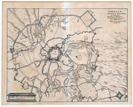
Groenlo, On
01.01.1627 (do 31.12.1627)This is a map of the town of Grolla in the Netherlands, which is surrounded by various fortification buildings and military camps. The above-quoted Latin text is shown in the top right-hand corner. Below the picture, there is a measuring scale.
Signature: Not available
Autor: Unknown
Original name: Grolla obsessa et expugnata ab illustrissimo Frederico Henrico principe Arausionensium comite Nassaviae. Auspiciis D.D. Ordinum Belgii confereari.
Katalogová čísla: Collection Český Šternberk, kód: 108/398
Frederick Henry Nassau was the most important personality in the Netherlands at the time of the Thirty Years' War. He was the brother of Maurice of Orange, who died, childless, in 1625. Therefore, political power and command of the army was transferred to Frederick Henry, who was not only a prudent and skilful politician but also an excellent commander; he was also educated and had a gentle, tolerant nature. Immediately after his appointment as high commander, he established and armed a force of 120,000 men, and the results soon showed. In a short time, he conquered almost all the Spanish towns and fortresses. The depicted Grolla fortress was conquered by the Dutch in 1627.
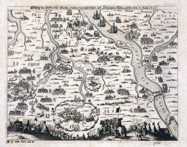
Blackede, On
13.06.1627The engraving depicts the countryside at the lower reaches of the Elbe and the Weser and Ems river basin. There are several towns depicted here, e.g. Hamburg, Bremen, Nordheim, Braunschweig etc. Troops are scattered throughout the entire area. On the right by the bridge is the town of Bleckede, where the main clash which is the subject of the picture took place. In the foreground are tents, several trumpeters and a woman with a pack basket.
Signature: Not available
Autor: Unknown
Original name: Abbildung des Treffens bey Bleckede, zwischen den Kayserlichen und Dennemarckischen geschehen den 13. Juny 1627.
Katalogová čísla: Collection Český Šternberk, kód: 100/49D
After a major defeat near Lutter on the 22nd of August 1626, Kristian IV. placed his troops in the area of the lower Elbe, Weser and Ems river basin, while the Imperial and League armies were located further south-east. As soon as Kristian of Denmark received reinforcements from the English king, he retreated with a part of his army from Bremen to the Elbe, and settled not far from Boitzenburg. At the end of May 1627 he sailed with his army to Bleckede, in order to occupy the fort there. But the general of the Imperial League troops, Duke George of Brunswick, came to know about his intentions and arrived with three cavalry regiments. A bloody clash followed, during which the Danes – though more numerous – were soundly beaten. King Kristian IV. hastily fled from the battlefield, and while boarding a ship fell into the Elbe and almost drowned.
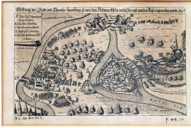
Havelsberg, On
01.08.1627 (do 31.08.1627)The picture depicts the area through which the Havel and Elbe rivers flow. On an island on the Havel river there is the town of Havelberg, and nearby there is Thumbhof, which means “a fortified hill with a church” (Thumb.Dom.). Downstream on the Havel river there are two forts facing each other, and between them an artillery barrage is shown. The Danes are just retreating from the fortress on the right. On the left, on the right bank of the Elbe, is the Imperial camp. In the left bottom corner of the print, a part of the town of Tangermünd is illustrated. At the top on the left-hand side is the legend A-E.
Signature: Not available
Autor: Unknown
Original name: Abbildung der Stadt und Thumbs Havelberg so von den Dennmarkischen verlassen und von den Kays. eingenommen worden. 1627.
Katalogová čísla: Collection Český Šternberk, kód: 101/177
After a defeat near Stadtlohn, and the loss of most of their most experienced generals such as Obentraut, Fuchs, Duke Jana Arnošt of Saxony-Weimer, young Kristian of Brunswick-Wolfenbüttel and Rantzau senior, the Danish King Kristian IV. controlled the Brandenburg territory north of Berlin. He appointed the elderly Count Thurn and George Frederick of Baden-Durlach as the new commanders. The latter occupied the right bank of the river Havel, from Rathenow towards Wittenberg. Towards the end of July, general Tilly advanced across the Elbe and left Hamburg as a supply centre at the rear of his army. As soon as Duke George of Bunswick, a commander serving the Emperor and the league, who controlled the left bank of the Havel including the town of Rathenow and part of the town of Havelberg which lies on the left bank of the river, found out about this movement, he decided to cross the Havel river and attack the Danish positions. He got ready to attack the following day, but in the meantime the Danes retreated to the east, as is depicted on our copperplate, so no major hostilities took place. The described event took place in the second half of August 1627.
La Rochelle, On
10.08.1627 (do 28.10.1627)On the height format, the town and fort of La Rochelle is depicted (the capital of the French department of Charente-Inferieure). At the top of the print, there is a harbour and three anchoring ships. Lower down, there is a town surrounded by ramparts and towers. The above inscription is in the image part of the print.
Signature: Not available
Autor: Unknown
Original name: Abrisz der Statt Rochelle in Frankreich.
Katalogová čísla: Collection Český Šternberk, kód: 102/86
In the 16th and 17th centuries, there were fierce and bloody battles in France with the Huguenots, i.e. the French Calvinist sect. The French state fought the Huguenots with all their resources (e.g. St. Bartholomew's Day). One of the last battles against the Huguenots was the siege and conquest of the La Rochelle fort and harbour by the royal army under the command of cardinal Richelieu, which lasted from the 10th of August to the 28th of October 1627.
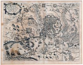
La Rochelle, On
10.08.1627 (do 28.10.1627)The town of La Rochelle is depicted from a so-called bird's eye view, with a harbour in which many ships are anchored. Around the town there are various military scenes, camps and field fortifications. In the bottom on the right there is a small map of the town environs. The quoted text is in a decorative cartouche in the top part of the picture.
Signature: Not available
Autor: Unknown
Original name: Wahrhafftige Abbildung der vesten Stadt Rochelle mit ihren fortificationen und dem königl. Läger und Schantzen. Anno 1627.
Katalogová čísla: Collection Český Šternberk, kód: 103/191a
In the 16th and 17th centuries, there were fierce and bloody battles in France with the Huguenots, i.e. the French Calvinist sect. The French state fought the Huguenots with all their resources (e.g. St. Bartholomew's Day). One of the last battles against the Huguenots was the siege and conquest of the La Rochelle fort and harbour by the royal army under the command of cardinal Richelieu, which lasted from the 10th of August to the 28th of October 1627.
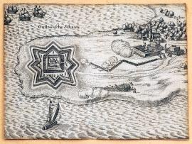
Gustow, On
01.12.1627 (do 31.12.1627)On the peninsula there is a fortress whose floor plan consists of a star with a building in the middle.
On the sea around the peninsula, five ships are sailing. On the dry land there is the small town of Gustow, protected by a field fortification. Troops are attacking the stronghold.
Signature: Not available
Autor: Unknown
Original name: Gustowische Schantz.
Katalogová čísla: Collection Český Šternberk, kód: 104/476
During Waldstein's operations in northern Germany in the year 1627, the Imperial general Arnim occupied Pomerania and the entire island of Rügen. At the same time, the entire Gustavian fort, which lies on the island of Rügen opposite the town of Stralsund on the Dönholm sea strait, was besieged and conquered. The invasion of Pomerania and the island of Rügen took place in November 1627.
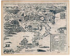
Wolfennbüttel, On
24.12.1627In the middle of the picture, there is the town of Wolfenbüttel, lying on the water. On both sides there are battling troops. Around the town there are several swamps and attackers' field fortifications, and at the bottom on the left there are two windmills. At the bottom on the right there is a square with the legend 1-22, and nearby there is a profile of a water dam.
Signature: Not available
Autor: Unknown
Original name: Eigentlicher Abrisz der Braunschweig. Vestung und fürstlichen Residenz Statt Wolfenbüttel, wie solche von Herrn Gottfried Heinrich Reichsmarschallen Herrn zu Pappenheim etc. ploquiert, ins Wasser gesetzt und den 24. Decembris 1627 eingenommen worden.
Katalogová čísla: Collection Český Šternberk, kód: 105/102
After the defeat of Kristian of Denmark near Lutter and Barenberg on the 27th of August 1626, the Imperial League side gained a significant advantage over the Protestant camp. For the entire year of 1627 it was occupied by Imperial territories, which had until now been under Danish control. The Danes occupied only a few fortified cities, among them Wolfenbüttel, which was besieged by the Imperial general Pappenheim until the 24th of December 1627, for a period of 4 months. The town garrison numbered 12,000 men under the command of Count Solms, who however abandoned the town and handed over command to general Lohem, who according to orders handed over the town to Pappenheim on the condition of free passage for the garrison, who then dispersed.
Wolfennbüttel, On
24.12.1627The etching depicts the town of Wolffenbüttel, surrounded by marshes. On both sides of the town there are battle skirmishes and gunshots from rifles. Small forests have been drawn in three places; several gallows have been built near one of them. Above the picture there is the above-quoted text; at the bottom there is a rectangle with the legend 1-12.
Signature: Not available
Autor: Unknown
Original name: Abrisz der vesten fürstlichen Statt Wolfenbüttel, wie solche in Nahmen Kay: May: durch den Gr. von Pappenheim belägert worden 1627.
Katalogová čísla: Collection Český Šternberk, kód: 106/342
During his first generalate, after the battle near Lutter (22nd of August 1626), where Tilly defeated Kristian of Denmark, Waldstein and his mighty army pursued the Danish king. The Danes were systematically defeated; only the town of Wolffenbüttel heroically resisted the occupying troops of general Pappenheim. The commander of the town garrison was Count Solms, who for four months successfully defended the town and only on the 24th of December 1627 was forced to hand over the town to his opponent, Count Pappenheim; this was actually done by his representative Lohe. Somls himself escaped from the town before the handover.
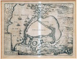
Stralsund, On
12.05.1628 (do 22.07.1628)The town of Stralsund has been schematically sketched; on one side there is the sea with a number of ships, and on the other side there is dry land with various fortified buildings (field fortifications and Imperial troops' bulwarks). In the right-hand corner of the picture there are two horsemen and an infantry division. On the left, in the square field, is the legend A-M; lower down there is a measuring scale in “Ruths”.
Signature: Not available
Autor: Unknown
Original name: Stralsundia
Katalogová čísla: Collection Český Šternberk, kód: 111/246
After a great victory at Dessau in 1626, Waldstein's army advanced triumphantly through Germany, all the way to the Pomeranian coast. But here they met the first obstacle which they could not overcome – the town of Stralsund. The siege was entrusted to general Arnim, who later transferred to the services of John George Elector of Saxony, and who also had a part to play in Waldstein's tragic end. There were long and fruitless negotiations with Stralsund town hall about handing over the town by Imperial agreement. The townspeople, however, later appointed a new Alderman council and decided to resist violently. Food and ammunition was supplied by sea by the Danes and Swedes. Infectious diseases erupted among the conquerors' ranks, the siege became unsustainable and Waldstein gave Arnim the order to withdraw with his troops. The siege lasted from the 9th of May until the 22nd of July 1628.
On
24.06.1628The etching depicts a fireworks display organized to celebrate the birthday of Elizabeth Duchess of Saxony, wife of John Philip of Saxony. The picture shows a house with a burning angel flying out of a window. Astonished people are depicted nearby. Under the picture, there are two four-line verses with a German greeting.
Signature: Johann Dürr Augustan sculpsit
Autor: Dürr Augustin Johann, německý mědirytec
Original name: Der durchlauchtige hochgeborene Fürst und Herr, Herr Johann Philips Hertzogk zue Sachsen Gühlich, Cleve und Berg, Landgraf in Düzingen, Markgrafe zur Meissen, Graf zu der Mergk und Ravensberg, Herr zu Ravensstein, mein gnädiger Fürst und Herr, hat der auch Durchlauchtigen, hochgeborenen Fürstin und Frawen Elisabethen Hertzogin zu Sachszen, geborene Hertzogin zu Braunschweig und Lünneburg etc. als Ihrer fürstl. G: herzliebsten Frawen Gemahlin, of dero Gebürtstag zu Ehren diesz vorgebildete Feuerwergk verfertigen und abgehen lassen, durch Ihr H. G. Zeugmeistern Joachim Kreichen am Tage Johannis Baptistae, den 24. Juny 1628.
Katalogová čísla: Collection Český Šternberk, kód: 110/52d
John Philip, Duke of Saxony-Altenburg, was born on the 25th of January 1597, married Elizabeth, princess of Brunswick, on the 25th of October 1618, and died on the 1st of April 1639. He was the son of Frederick William I. Duke of Saxony-Altenburg. His wife was Elizabeth of Brunswick-Lüneburg, daughter of Henry Julius of Brunswick-Lüneburg, born on the 23rd of June 1593; in her first marriage she was the wife of Duke Augustus of Saxony, in 1615 she became a widow and, three years later, married John Philip of Saxony-Altenburg. The depicted fireworks display was organized on the day of Elizabeth's 35th birthday. She died on the 25th of March 1650.
Toruň, On
01.07.1628 (do 31.08.1628)The drawing of the town of Toruň has been carried out very diligently and in great detail; the Latin text shown is in the decorative cartouche at the top on the left. Further down, there is the legend A-Z. The picture is full of explanatory notes. In the foreground, there is the „Vistula fluvius“ (river Visla) with a ship and a bridge.
Signature: Not available
Autor: Hoffman Jacob, architekt a geometr
Original name: Civitas Thorinum una cum sua fortifikatione accurate delineata per Jacobum Hoffmannum geom. et archit. Hic per incendium devastatio facta A. 1628 omnium suburbiam per oppugnationem, quae facta a generoso Hermanno Frangel.
Katalogová čísla: Collection Český Šternberk, kód: 109/251
Before Gustav Adolf landed with his army in 1630 on German territory, he waged was against Poland which at the time was ruled by King Sigismund. In 1627, Gustav Adolf besieged Gdańsk, but he did not succeed in conquering it. The town garrison was commanded by Arend Dickmann. The next year, however, the Swedes won a naval battle against the Poles who were led by Koniecpolski. But a huge flood prevented the Swedes from conquering and occupying Gdańsk, which is why Gustav Adolf was forced to conduct military operations in the Polish hinterland. As part of this campaign, he also besieged the town of Toruň, situated approximately 100 km south of Gdańsk on the Vistula. Judging by the Latin text on the copperplate, this siege was led by Herman Frangel, who apparently is not the same person as general Carl Gustaf Wrangel.
Glückstadt, On
01.07.1628 (do 31.07.1628)The copperplate is a Merian work, and apparently comes from Abelin's “Theatra Europaea“. It depicts the Elbe countryside not far from Hamburg, with the towns of Kempen and Glückstadt and field fortifications, bulwarks and military divisions nearby. Danish ships are sailing on the Elbe. The legend A-G is at the top on the right, on the uncoiled ribbon.
Signature: M. Merian fecit
Autor: Merian Mateus, mědirytec a nakladatel ve Frankfurtu nad Mohanem
Original name: Die Bloquierung Krempen und Glückstadt, so von Herrn General ihr Exc. Tilly vorgangen im Julio 1628.
Katalogová čísla: Collection Český Šternberk, kód: 112/88
At the time of Waldstein's victorious campaign across Germany, which culminated in the siege of Stralsund, Waldstein controlled all the territory on the right bank of the Elbe, while Tilly commanded the Imperial League defence forces (the combining of the defence forces is not an appropriate note – ed) on the left bank. At that time, Tilly tried to conquer the towns of Kempen and Glückstadt near Hamburg, but only succeeded in surrounding these towns. Kempen was conquered by Waldstein on the 12th of November 1628, and Glückstadt continued to resist.
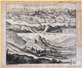
Chur, On
01.01.1629 (do 10.01.1629)The sheet is divided into two pictorial parts; the lower part depicts the small town of Chur on the Rhine in western Switzerland, and the upper part shows the Rhine countryside with high mountains, the Rhine and a bridge. In the countryside there is a large number of small settlements, castles, fortresses etc.
Signature: Not available
Autor: Unknown
Original name: Eigentliche Verzeichnuss des Passes von der Steig bisz gehn Chur in Pünten, welches sich die Keyserl. impatroniert Anno 1629.
Katalogová čísla: Collection Český Šternberk, kód: 114/42d
In December 1627, Vincent Duke of Mantua from the family of the Dukes of Gonzaga died with no descendants, which resulted in a struggle for succession. The French (chancellor Richelieu) supported Charles Duke of Nevers in this struggle, who also quickly occupied Mantua. Emperor Ferdinand II., however, opposed the French efforts at the instigation of the Spanish, and after long and fruitless negotiations he sent out troops under general Count Mérode who then occupied Mantua. In 1629, These troops advanced through the pass at Steig and Chur in western Switzerland. After this action by the Emperor, cardinal Richelieu, at the head of the French army, set out for Italy. Meanwhile, however, Duke Charles Emmanuel of Savoy joined the Imperial-Spanish side, thus making it impossible for Richelieu to reach Mantua with his troops. Mérode's army later also received reinforcements in the form of general Collalt's divisions, and on the 18th of June 1630 Mantua fell into the arms of the Imperial troops. Richelieu, however, conquered Savoy and prepared for his subsequent campaign in Italy.
Hertogenbosch, On
01.01.1629 (do 31.12.1629)This is a very accurate, mapped situation of the environs of the town of Herzogenbusch in the north of the Brabant province in the Netherlands. On the right is the river Meuse. The wide surroundings of the town are filled with an extensive system of bulwarks and field fortifications. Above the picture there are two emblems. On the right, near a bend in the Mosel, there are two cartouches decorated with weapons, with the inscription: “Rheinländische Rutten“. Another cartouche contains the above-mentioned text. There is a measuring scale nearby.
Signature: Durch Jakobb Prempart ingenieur
Autor: Prempart Jakob, fortifikační inženýr a kreslíř map a plánů
Original name: Wahre und eigentliche Delineatio der trefflichen und weitberühmten Belägerung der vesten Stadt Herzogenbusch, alles nach seiner rechten Mass abgetheilt.
Katalogová čísla: Collection Český Šternberk, kód: 115/12
At the start of the 17th century, the Netherlands and Spain were engaged in protracted battles punctuated by short-lived truces, lasting until 1621. After that, more battles broke out. On the States-General side these were led by Maurice, and later by his brother Frederick Henry of Nassau. Maurice died in 1625; Frederick Henry however conquered a number of Spanish-occupied towns with great victories, among them Maastricht and Herzogenbusch in 1629.
Wesel, On
01.01.1630 (do 31.12.1630)The copperplate depicts the Rhine and two fortresses. On the peninsula, beside the shipping bridge which is just being built, stands a cargo crane whose system is remarkably effective and built in a modern way. The crane is unloading cargo from ships. A little further is the fortified town of Wesel, from which the Spanish are retreating on one side, and the Dutch are entering on the other. The cartouche with the legend A-I is a very interesting allegory: the figure representing Spain is holding a chain to which a lion is tied (i.e. the Netherlands). The lion is holding two banners with the inscriptions Herzogenbusch and Venloo. Under the chain there is the inscription “Wesel”. A hand is coming out of the clouds, holding a scissors which it is using to cut the chain. The hand is labelled with the inscription “Hand Gottes“.
Signature: Not available
Autor: Unknown
Original name: Wesel
Katalogová čísla: Collection Český Šternberk, kód: 124/448
The town of Wesel was conquered by the troops of Frederick Henry of Orange, who was the most successful Dutch commander and diplomat and achieved many significant victories over Spain, who for many years fought for their territories in the Netherlands, mainly with the help of Austrian troops from the Netherlands (now Belgium). In 1629, Frederick Henry of Orange conquered the town of Herzogenbusch, a military success of the first order which won the admiration of the entire world at that time and attracted many applicants to the military, who wanted to learn Frederick Henry of Orange's new fortress conquering technique. He soon took Venlo away from the Spanish as well, and in 1630 he captured the town of Wesel which is illustrated here.
Casal, On
24.05.1630 (do 18.10.1630)On the left-hand side of the picture, the river Po and the town and citadel of Cazal are depicted. The illustrated scene is explained with French and Dutch text. On the right-hand side there is a detailed depiction of the citadel, and lower down a measuring scale is shown. The decorative ribbon contains the town emblem and the legend 1-10. In the bottom right-hand corner there is a perspective view of the town and countryside.
Signature: C. J. Visscher excudebat
Autor: Visscher C. J., mědirytec
Original name: Plan de la ville et citadelle de Cazal assiégée par le M. de Spinola de 24. mai 1630. et deffendue par M. de Toyras jusque au 18. octobre quelle a este secourae par les armes du Roy de France Lous le 13 me.
Katalogová čísla: Collection Český Šternberk, kód: 121/51d
In the war for succession in the Duchy of Mantua (see the detailed historical commentary under no. 114/42d on page 93) the Spanish, under the command of Marquis Ambrose Spinola, besieged the town and citadel of Cazal, west of Turin in the province of Alessandria. The town was temporarily occupied by the troops of the Duke of Nevers, who was supported by France. The town garrison was under the command of Marquis de Toryas. On the 18th of October 1630, the town was freed from the Spanish siege by the French. Marquis A. Spinola died soon afterwards.
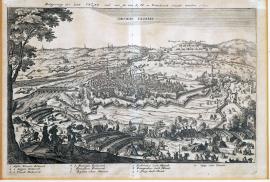
Casal, On
24.05.1630 (do 18.10.1630)This is a view of the Po lowlands, in the middle of which lies the town of Cazal above the river Po. In the foreground there are artillery batteries and military camps; on the left under a tree there are three officers studying a map. In the background there are military divisions and behind them there are Alpine mountain panoramas. In the sky there is the inscription “Obsidio Casalis“. Above the picture there is the quoted German text and the legend 1-10.
Signature: Not available
Autor: Unknown
Original name: Belägerung der Stadt Cazal und wie sie K. M. in Frankreich entsetzt worden 1630.
Katalogová čísla: Collection Český Šternberk, kód: 122/343
In the war for succession in the Duchy of Mantua (see the detailed historical commentary under no. 114/42d on page 93) the Spanish, under the command of Marquis Ambrose Spinola, besieged the town and citadel of Cazal, west of Turin in the province of Alessandria. The town was temporarily occupied by the troops of the Duke of Nevers, who was supported by France. The town garrison was under the command of Marquis de Toryas. On the 18th of October 1630, the town was freed from the Spanish siege by the French. Marquis A. Spinola died soon afterwards.
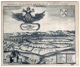
Řezno, On
15.06.1630 (do 31.08.1630)The engraving, with a view of the city of Regensburg on the Danube, has been carefully drawn. In the foreground there are fields divided by borders; at the bottom on the left there is an allegorical gate with the city's coat of arms and a male figure which is looking at the city. At the bottom on the right, the legend A-O is shown in two rectangles. In the sky above the city there is a large Imperial eagle, holding in its talons a decorative board with a tribute to Emperor Ferdinand II.: “Divo Ferdinando etc.“. On the right-hand side there is the city emblem with the inscription: “Ratisbona“.
The above-quoted German text is located above the picture.
Signature: Not available
Autor: Unknown
Original name: Abcontrafeitung der Stadt Regensburg, darin dieser Zeit der Churfürstliche Colegialtag gehalten worden 1630.
Katalogová čísla: Collection Český Šternberk, kód: 120/458
In 1630, Ferdinand II. convened an electoral assembly in Regensburg, which commenced on the 15th of June. At this event, the Emperor particularly wished to push his son Ferdinand through as pretender to the Roman Emperor. Being Protestants, the Electors of Saxony and Brandenburg refused to take part in the assembly. In the end, only Catholic princes came. At the instigation of the Electors, the main subject of the talks became the issue of dismissing Waldstein from his powerful position as Imperial Generalissimo. After protracted negotiations, and having used all the resources at their disposal to put pressure on the Emperor, the participants in the assembly pushed through Waldstein's dismissal. It was an extremely serious decision, and its consequences later backfired on the Emperor. The question of whether Waldstein, if he had been spared the disgrace of being unseated after all the merits gained for the Emperor, would not later have taken the path of treason, remains open. Ferdinand II.'s efforts to push through the election of Ferdinand III. as Roman-German Emperor also failed. The progress and results of the assembly show Emperor Ferdinand II. as being quite powerless and incompetent; the reasons for this also lie in the way in which the empire was governed, which after the 17th century was no longer suitable in its old, original form.
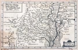
Mantova, On
18.06.1630On the right side of the engraving, the Po river has been drawn; on the left are the ridges of the Apennines. On the top left-hand corner there is a rectangle with the quoted text. All the edges are marked with the measuring scale “Miliaria italica“.
Signature: Not available
Autor: Unknown
Original name: Abrisz des Herzogthumbs Mantua mit den umliegenden Landschafften. 1630.
Katalogová čísla: Collection Český Šternberk, kód: 117/36d
In December 1627, Vincent Duke of Mantua from the family of the Dukes of Gonzaga died with no descendants, which resulted in a struggle for succession. The French (chancellor Richelieu) supported Charles Duke of Nevers in this struggle, who also quickly occupied Mantua. At the instigation of the Spanish, however, Emperor Ferdinand II., opposed the French efforts, and after long and fruitless negotiations he sent out troops under general Count Mérode who then occupied Mantua. In 1629, These troops advanced through the pass at Steig and Chur in western Switzerland. After this action by the Emperor, cardinal Richelieu, at the head of the French army, set out for Italy. Meanwhile, however, Duke Charles Emmanuel of Savoy joined the Imperial-Spanish side, thus making it impossible for Richelieu to reach Mantua with his troops. Mérode's army later also received reinforcements in the form of general Collalt's divisions, and on the 18th of June 1630 Mantua fell into the arms of the Imperial troops. Richelieu, however, conquered Savoy and prepared for his subsequent campaign in Italy.
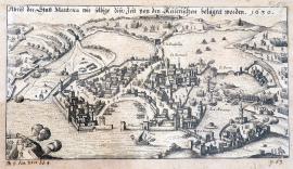
Mantova, On
18.06.1630This is a very accurately executed depiction of the battle for the town of Mantua. Mantua itself is very carefully and accurately engraved; the town is surrounded by water. In the left foreground, there are three firing cannons. The quoted German text is located in the upper part of the etching.
Signature: Not available
Autor: Killan Lucas, mědirytec
Original name: Abrisz der Stadt Mantua, wie selbige diese Zeit von den Kaiserischen belägert worden. 1630.
Katalogová čísla: Collection Český Šternberk, kód: 117a/484d
In December 1627, Vincent Duke of Mantua from the family of the Dukes of Gonzaga died with no descendants, which resulted in a struggle for succession. The French (chancellor Richelieu) supported Charles Duke of Nevers in this struggle, who also quickly occupied Mantua. Emperor Ferdinand II., however, opposed the French efforts at the instigation of the Spanish, and after long and fruitless negotiations he sent out troops under general Count Mérode who then occupied Mantua. In 1629, These troops advanced through the pass at Steig and Chur in western Switzerland. After this action by the Emperor, cardinal Richelieu, at the head of the French army, set out for Italy. Meanwhile, however, Duke Charles Emmanuel of Savoy joined the Imperial-Spanish side, thus making it impossible for Richelieu to reach Mantua with his troops. Mérode's army later also received reinforcements in the form of general Collalt's divisions, and on the 18th of June 1630 Mantua fell into the arms of the Imperial troops. Richelieu, however, conquered Savoy and prepared for his subsequent campaign in Italy.
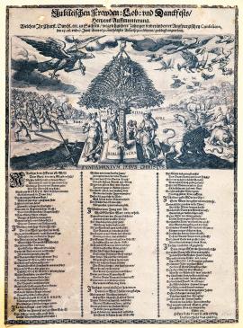
On
25.06.1630 (do 27.06.1630)In the middle of the plate, on which there is the inscription “Fundamentum Jesum Christum“, is the Bible “biblia sacra“, from which a palm tree grows with the inscription: „confes. August“ on its trunk. In the crown of the tree there is Constantia (endurance) and near the trunk there is: Fides (fidelity), Charitas (mercy) and Spes (hope). On the right-hand side, a Swedish lion is repelling various wild animals. A Brandenburg eagle is flying from the left and chasing away wild birds; near the tree there are two crossed swords tied with a laurel branch (i.e. the emblem of Saxony), repelling enemy troops. There is a hand coming out of the clouds, holding a chain which is tied to the crown of the palm tree, which symbolizes the hand of God protecting the Church of Augsburg. Under the picture there is a extensive three-verse German poem which explains the meaning of the depicted scene.
Signature: Not available
Autor: Unknown
Original name: Jubileischen Frewden – Lob und Dankfest Hertzens Aufmunterung, welches Ihr. Churf. Durchlaucht etc. zu Sachsen wegen hundertjähriger unveränderter Augspurgischen Confesion, den 25. 26. und 27. Junij 1630 mit höchster Andacht zu celebrieren gnädigst angeordnet.
Katalogová čísla: Collection Český Šternberk, kód: 118/123
This sheet was issued on the occasion of the one hundredth anniversary of the founding of the Augsburg Confession in 1630. During this time, Sweden and Brandenburg were Saxony's main allies. This military alliance, however, was not nearly as reliable or honest as mentioned in the words and depicted in the pictures in the leaflet. Saxony itself, in particular, was a very unreliable ally due to the character of John George I. the Elector.
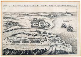
Peenemünde, On
01.07.1630 (do 31.07.1630)Immediately after landing on German soil near the island of Rügen on the 4th of July 1630, Gustav Adolf of Sweden began fortifying several locations on the coast so that he could safely carry out operations further into the German hinterland. These footholds included the Peenemünd fortress, located near the outlet of the river Oder into the sea, south of the island of Rügen. The king also had a similar fixed point established near Wollgast, not far from Peenemünd. Defensive actions by Imperial forces against the landing and attacking Swedes were feeble, since the Imperial forces were thinly scattered across the whole of Pomerania and Mecklenburg.
Signature: Not available
Autor: Unknown
Original name: Abbildung der Peenemünder Schantz und Seehaffen sampt dem königlichen schwedischen Läger.
Katalogová čísla: Collection Český Šternberk, kód: 119/464
This is a slightly smaller copperplate; on its right-hand side there is the Baltic sea with two sail-boats near the mouth of the river Oder. Imperial and Swedish fortifications are facing each other. In the foreground, a small forest and the so-called “Lusthaus” are depicted. The above-quoted text is located above the picture.
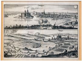
On
04.07.1630The print contains two views of the town of Wollgast from two locations various distances away. From the first, closer viewpoint, a castle on an island in the sea can be seen; in the foreground there are two firing cannons. The other, more distant view shows the town with the Swedish camp and conqueror's ramparts in the foreground. On the left there is a burning village.
Signature: Not available
Autor: Unknown
Original name: Wollgast. In wehrender belagerung dieser Stadt hat sich über dem Schloss dieses Wunderzeichen, ein Loew und Adler streitende in der Luft sehen lassen Angesichts der ganzen Armeen.
Katalogová čísla: Collection Český Šternberk, kód: 116/228
After landing on the island of Usedom in the Baltic sea, Gustav Adolf of Sweden prepared to advance to Germany with his army, in order to secure his strategic bases on the coast. For this purpose, the town and fortress of Wollgast, located on the coast opposite the island of Usedom, had to be seized. Gustav Adolf carried out this military action during July 1630; it was quite difficult and resulted in significant sacrifices by both sides, but Wollgast was conquered in accordance with the king's plan. The supernatural, miraculous apparition which is mentioned in the above-quoted German text on the engraving, is something we often come across in the 17th century and was no doubt a result of the fantasies of some of the so-called “eyewitnesses”.
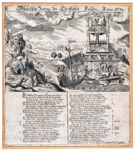
On
04.07.1630The print shows an unusual building on three pillars standing on a book (i.e. on the Bible) in a mountainous landscape – at the top is the “ecclesia“ church. The three pillars represent: Omniscinecia, Misericordia and Omnipotentia. The book is labelled with the inscription: “Verbum Domini manet in aeternum“. This is because the Bible forms the basis of the Protestant faith. In front of the building there are five pillar ruins and bases, of which three are labelled: Bohemia,
Palatinate and Augsburg, and are lying beneath a monster. The ruins represent the pillars of the Protestant faith, defeated by the Emperor and the league. The monster represents the Catholic faith and its heads carry the emblems of the Pope, cardinals and other church dignitaries. A sailboat with the Swedish lion and a Dutch helm is approaching this scene (i.e. and allegory of the alliance between Sweden and the Netherlands). On the rocky coast from which the ship set sail there is a person standing upright and teaching a group of pupils. By this the author of the print wants to state that the country from which the ship is sailing, i.e. Sweden, still has correct and pure reformed (Lutheran) teaching. The sun, which is just at that moment emerging from the clouds, shines its rays only on the ship and the teacher of Lutheran faith above Sweden, on the rocky coast, which means that God is helping the Swedes who are landing on German soil. Beneath the picture there is an extensive German poem, which very theatrically (in the form of a dream) explains the depicted scene and describes the Swedes' arrival in Germany as the rescue of the Christian Church which had been driven to the brink of extinction by the Roman Papacy.
Signature: Not available
Autor: Unknown
Original name: Schwedische Rettung der Christlichen Kirchen Anno 1630.
Katalogová čísla: Collection Český Šternberk, kód: 125/141
This sheet deals with the arrival of Gustav Adolf of Sweden and his army in Germany on the 4th of July 1630. In this important event, the author of the engraving sees a turnaround in the political and religious situation in the empire. The engraving is also notable due to its large number of various allegorical scenes, most of which are tastefully drawn and bear witness to the author's considerable skill.
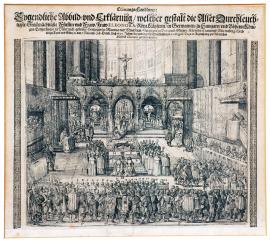
Řezno, On
28.10.1630The picture represents the interior of the Regensburg house in which Eleonora of Mantua was crowned Roman Empress. Above the chancel there is a large cross under which, in front of the altar, kneels the Empress with three bishops, of which one is placing the crown on her head. On the left, underneath a canopy, kneels the Emperor. The whole space is filled by a large number of various dignitaries.
Signature: Not available
Autor: Unknown
Original name: Crönungshandlung: Eygentliche Abbildung und Erklärung, welcher Gestalt die allerdurchlauchtigste Fürstin und Fraw, Fraw Eleonora röm. Kayserin in Germanien zu Hungarn und Böheim Königin, Erzherzogin zu Oesterreich, geborene Herzogin zu Mantua, Herzogin zu Burgund etc. den 7. November (28. October) desz 1630 Jahres bey Endung des Churfürstlichen Collegialtages in Regenspurg zur römischen Kayserin soleniter gekrönet worden.
Katalogová čísla: Collection Český Šternberk, kód: 123/295
Eleonora of Gonzaga, Duchess of Mantua, second wife of Emperor Ferdinand II., was crowned Roman-German Empress in Regensburg on the occasion of the fateful electoral assembly, the so-called “Reichstag” on the 28th of October 1630. At this assembly, some of the electors led by Maximilllian of Bavaria enforced the dismissal of Waldstein from Imperial services.
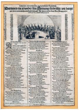
On
01.01.1631 (do 10.01.1631)The picture shows a meeting of all the rulers standing in the anti-Imperial camp, and representatives of major cities, i.e. England, France, Württemberg, Sweden, Nuremberg, Strasbourg, Ulm and many others. The chairman of the meeting is the “restless spirit“ (unruhiger Geist) seated at the head of the table. Away from the meeting hall, there is the Emperor on the right and the Catholic Church on the left. Under the picture there is a long German poem, in which each participant in the meeting expresses their views and complaints.
Signature: Not available
Autor: Unknown
Original name: Lutherisch und Calvinisch jüngst gehaltener Rathschluss darinnen ein jadweder sein Meinung fürbringt, wie dargegen (dero eigenen wahren Bekenntnusz nach) ihr Intent wider Kay. May. zurugg gehet und klagen wie es etlichen übel ergangen ist. Gedruckt im Jahr 1631.
Katalogová čísla: Collection Český Šternberk, kód: 126/156
The leaflet was issued by Catholics at a time when Imperial forces controlled all of Germany and when the Protestant side was very despondent. The speeches by participants in the meeting, even if they had not already succumbed to despair, are of a similar tone.
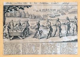
Breitenfeld, On
01.01.1631 (do 31.12.1631)Tilly, with three of his generals, is sitting at a table with several bowls. He is being approached by a Swedish lion holding a map, representing the Battle of Leipzig, and by Gustav Adolf of Sweden with two platters containing Mainz and Würzburg; he is followed by John George of Saxony with Prague and the Landgrave of Hessen carrying Fulda. General Gustav Horn, carrying Bamberg in a bowl, is last. In the background, the Battle of Leipzig is illustrated. Beneath the picture there is an extensive German poem explaining the illustrated scene.
Signature: J. v. d. Heyden
Autor: Heyden Jacob van der, holandský rytec a nakladatel se sídlem ve Strasburku
Original name: Etliche Schauessen so dem Sächsischen Confect gefolgt.
Katalogová čísla: Collection Český Šternberk, kód: 144/58
This is a pamphlet comparing the military defeats of the Imperial forces by the Swedish army with a banquet at which Tilly and his companions are forced to eat meals which they cannot digest. The Swedish lion is bringing the bitter defeat at Breitenfeld (at Leipzig). Gustav Adolf is bringing the conquered towns of Würzburg and Mainz, John George I. Elector of Saxony is offering Tilly Prague, which his general Arnim conquered, the Landgrave of Hessen who fought on the Swedish side is bringing the conquered town of Fulda in a bowl, and the Swedish general Gustav Horn is carrying conquered Bamberg on a plate. Tilly and his companions are forced to eat these bitter meals.
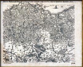
Meklenbursko, On
01.01.1631 (do 31.12.1631)This is a map of the territories of Mecklenburg, Pomerania and Brandenburg. The Oder flows on the right-hand side; at the bottom on the left there is a small stretch of the river Elbe. In the north are the mapped territories bordered by the sea (“Maris Balthici Pars“),
on which a ship is sailing. The entire area of the print is filled with geographical signs.
Signature: Not available
Autor: Unknown
Original name: Abrisz der Mecklenburgisch-Pommerisch und Brandenburgischen Landschaften, da jetztiger Zeit der Krieg zwischen den Keyserisch und Schwedischen geführt wird 1631.
Katalogová čísla: Collection Český Šternberk, kód: 162/46d
On the 4th of July 1630, King Gustav Adolf of Sweden landed on German soil near the island of Usedom. As soon as the entire Swedish army was on dry land, military actions commenced. However, negotiations with various north German princes also started. Waldstein later appeared here and besieged the town of Stralsund, which he did not conquer due to determined resistance by the town garrison, but with his mighty army he was still a great danger to the Swedes. Soon, however, the electoral assembly in Regensburg enforced the Emperor's dismissal of Waldstein from the function of generallisimo and from Imperial services. The sole supreme commander of the Imperial League troops who remained here was Tilly, with whom Gustav Adolf already knew how to deal (with the help of John George I. Elector of Saxony) at Breitenfeld on the 17th of September 1631. Before Waldstein's dismissal from Imperial services, at the time of his triumphant campaign across all of northern Germany, the Emperor conferred Mecklenburg on him as a sovereign duchy. Its previous owner was guilty of disloyalty to the Emperor.
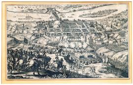
Frankfurt nad Odrou, On
03.04.1631Here we see a view of the city conquered on the 3rd (13th) of April 1631 by the Swedes. In the background we can see the flow of the Oder with a large bridge and island, across which Imperial forces are fleeing. On the other bank there are many men on the run. The city is under strong Swedish artillery fire. In the left foreground there is an artillery division with the trumpeter and standard-bearer's horse rearing up. On a nearby hillock, there are two more trumpeters. The usual explanatory text is missing here.
Signature: Not available
Autor: Unknown
Original name: Frankfurt a/Oder“ – „Francfurtum ad Viadrum.
Katalogová čísla: Collection Český Šternberk, kód: 128/407
As early as the end of 1630, Gustav Adolf had managed to occupy the whole of Pomerania and advance all the way to the Oder. In order to gain a strong base for further progress into Silesia, the Swedish king decided to conquer Frankfurt-on-Oder in the spring of 1631. He needed this city just like Tilly needed Magdeburg; a fortified, strategic location on the Oder. The conquest of Frankfurt was also one of the reasons preventing the Swedes from taking timely action to liberate the suppressed Magdeburg. Gustav Adolf stayed with his army in a fixed camp near Schwendt and made use of stronger divisions under the command of generals Horn and Banér, and to a certain extent also of ships headed for Frankfurt where Imperial generals Tiefenbach and Schaumburg commanded 8,000 men. On the 3rd (13th) April, the Swedes carried out an attack on the city which crushed any opposition by the defenders. In the confusion, Imperial forces fled across the bridge in the direction of Great Hlohovec. Many men drowned during the chaotic escape across the Oder.
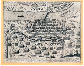
On
13.04.1631The upper part of the picture shows the wide flow of the Oder, with a bridge and an island lying a short distance away on the right-hand side. On the city streets, a large number of persons running around in confusion has been drawn in great detail. The city is surrounded by the Swedish army, firing from numerous cannons. In the right foreground there are two figures of musketeers. Under the picture there is the legend A-M; the quoted text is located above the picture.
Signature: Not available
Autor: Unknown
Original name: Eigentliche Abbildung welcher gestaldt Ihr. Köngl. Majest. in Schweden den 3. Aprillis Anno 1631 die Stadt Franckfort an der Oder berandt und eingenommen hat.
Katalogová čísla: Collection Český Šternberk, kód: 127/235
After Gustav Adolf landed on German soil with his army, the Swedes had certain difficulties at the start before they managed to enter the German hinterland. Most of all, the Swedes wanted to liberate Magdeburg from general Tilly's siege, who had gripped the city at the beginning of 1631. The main obstacle to this Swedish liberation action was the city of Frankfurt-on-Oder. The successful generalissimus Waldstein had already been dismissed from Imperial services, and the supreme commander of the Imperial League armies was Tilly. The commander of the Frankfurt garrison was the Imperial general Count Schaumburg, who was subject to the command of general Tiefenbach. The city was well secured with solid fortifications and weaponry. Nevertheless, the Swedes managed to enter Frankfurt in quite a short time and defeat the garrison, of which approximately 2,000 men were slaughtered during the confusion and stampede caused by the sudden Swedish invasion. The prisoners, mainly Croats, were deported to Swedish mines to extract copper. Unfortunately, this and similar exploiting of prisoners of war can be witnessed from the reign of the Pharaohs in ancient times until the present day.
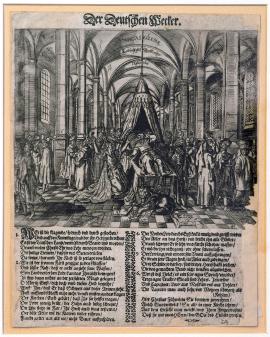
On
01.05.1631 (do 30.09.1631)On the picture is the interior of a huge temple, in the middle of which is a high bed with skies above it. On the bed lies a person who is just now waking up. It is John George I. Elector of Saxony, being awakened by a kneeling woman, clad in tattered clothes, who is screaming desperately. This represents Germania, i.e. Germany, which ended up in a frightening position due to the actions of the Imperial troops; naturally this means Protestant Germany. In front of the bed is a (Swedish) lion whose paws are resting on the coats of arms of Venice, Switzerland and Hanseatic towns. These three states were faithful allies of the Swedes. Beneath the picture is an extensive German poem, explaining the illustrated scene.
Signature: Not available
Autor: Unknown
Original name: Der Deutschen Wecker.
Katalogová čísla: Collection Český Šternberk, kód: 136/147
This is a propagation leaflet, exhorting all followers of the Protestant faith to pull together and rise up in arms against the danger of Imperial Catholicism. For a long time Saxony hesitated, recognized the central Imperial power and refused to affiliate itself with the alliance of Protestant powers; only the cruel annihilation of Mandeburg by Imperial forces and looting by Imperial divisions on their territory induced them to openly oppose the Emperor. This situation is an allegory - the humiliated, tattered Germania is waking up the hesitant, sleeping Elector of Saxony. According to the poem, the crowd of people surrounding this scene is searching for only one God, who is in heaven. Capuchins, Jesuits, blacks, Tatars, Poles and many others are shown here. Perhaps the meaning is that there may be a unification of all Christian churches, but in a Protestant sense. Or possibly the author of the print wishes to state that a friendly co-existence of both of the main German churches is desirable; this actually did come about later.
Magdeburk, On
10.05.1631This is a small picture of the city of Magdeburg, besieged by Imperial troops. In the foreground there is a military scene with horsemen and banners. The troops are advancing across a bridge over the Elbe. In the background, the city is shrouded in smoke and flames. The quoted Dutch inscription is located on an uncoiled banner in the sky; beside it is the city emblem and an Imperial eagle with a laurel branch around it. The etching is a remarkable, extraordinarily beautiful and delicately made work of art, but it is virtually unknown. Even its great author is unknown.
Signature: Not available
Autor: Unknown
Original name: Maegdenburgh. D´Innemingh Maegdenburgh door de keysersche.
Katalogová čísla: Collection Český Šternberk, kód: 129/226
When Ferdinand II., at the insistence of some of the electors – mainly Maximillian of Bavaria – dismissed his experienced generalissimo Waldstein from Imperial services, general Tilly became the only commander of the Imperial League. Gustav Adolf was still far away and engaged in Brandenburg, so for strategic reasons he could not get near Tilly with his army in order to liberate the city of Magdeburg which Tilly had gripped in his siege. The Imperial forces had already besieged Magdeburg since December 1630; the incompetent city council did not skilfully use their military forces, and the city was already suffering a noticeable lack of all kinds of supplies. Gustav Adolf was informed about this state of affairs, but he was engaged in the conquest of Frankfurt-on-Oder, which is why he merely sent his confidant Falkenberg in secret into Magdeburg. After that there were long negotiations about handing over the city to Imperial forces on the basis of an agreement, but this never took place. On the 10th May 1631, the Imperial general Count Pappenheim suddenly entered the city with a large division, followed immediately by the entire army which was waiting for a rich haul. The attack was a complete surprise, and the city defenders fled in confusion. The Imperial troops plundered and devastated the city terribly, and murdered the civilian population. General Tilly, who initially allowed the looting, later could not control his crazed troops and was forced to order bloody executions. The destruction was completed by a huge fire which engulfed the entire city and razed it to the ground. This outrageous rampage by the Imperial troops in Magdeburg significantly increased the Protestants' hatred and anger towards the Catholics, which also showed itself in a great number of various leaflets and pamphlets which were issued in connection with the fall of Magdeburg. The conquest of Magdeburg was the last significant Imperial victory; there was a turnaround in the Thirty Years' War and the Protestants once again prevailed, mainly due to the Swedes, but also as a result of the victories of Frederick Henry of Orange (Netherlands) over the Spanish.
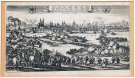
Magdeburk, On
20.05.1631The print depicts the conquest of Magdeburg by Tilly in 1631. The high artistic level of the engraving and the distinctive character of the composition bears witness to Merian's authorship, although the print has not been signed. In the middle of the picture is the river Elbe, spanned by a bridge across which troops are advancing. The burning city is in the background, and in the foreground there is a cavalry division.
On the uncoiled banner in the sky, there is the legend 1-25, and on the sides there are the city and Imperial coats of arms.
Signature: Not available
Autor: Unknown
Original name: Magdeburgum
Katalogová čísla: Collection Český Šternberk, kód: 130/375
When Ferdinand II., at the insistence of some of the electors – mainly Maximillian of Bavaria – dismissed his experienced generalissimo Waldstein from Imperial services, general Tilly became the only commander of the Imperial League. Gustav Adolf was still far away and engaged in Brandenburg, so for strategic reasons he could not get near Tilly with his army in order to liberate the city of Magdeburg which Tilly had gripped in a siege. The Imperial forces had already besieged Magdeburg since December 1630; the incompetent city council did not skilfully use their military forces, and the city was already suffering a noticeable lack of all kinds of supplies. Gustav Adolf was informed about this state of affairs, but he was engaged in the conquest of Frankfurt-on-Oder, which is why he merely sent his confidant Falkenberg in secret into Magdeburg. After that there were long negotiations about handing over the city to Imperial forces on the basis of an agreement, but this never took place. On the 10th May 1631, the Imperial general Count Pappenheim suddenly entered the city with a large division, followed immediately by the entire army which was waiting for a rich haul. The attack was a complete surprise, and the city defenders fled in confusion. The Imperial troops plundered and devastated the city terribly, and murdered the civilian population. General Tilly, who initially allowed the looting, later could not control his crazed troops and was forced to order bloody executions. The destruction was completed by a huge fire which engulfed the entire city and razed it to the ground. This outrageous rampage by the Imperial troops in Magdeburg significantly increased the Protestants' hatred and anger towards the Catholics, which also showed itself in a great number of various leaflets and pamphlets which were issued in connection with the fall of Magdeburg. The conquest of Magdeburg was the last significant Imperial victory; there was a turnaround in the Thirty Years' War and the Protestants once again prevailed, mainly due to the Swedes, but also as a result of the victories of Frederick Henry of Orange (Netherlands) over the Spanish.
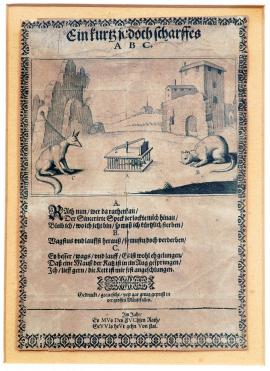
On
20.05.1631In the middle of the picture there is an open mousetrap in which a mouse is sitting; on the right-hand side there is a cat lying in wait, on the left-hand side there is a fox chained to a rock with a house behind it. Beneath the picture there is a German poem with a conversation between the mouse A, cat B and fox C. The mouse (i.e. Magdeburg) asks: Should I go get the pork fat which has been laid out and leave the trap, or should I stay here, which will mean an early death? The cat (i.e. Tilly) replies: “If you dare to run out from the trap, you will be destroyed anyway!” The fox (i.e. Gustav Adolf) says: “Go now and run, mouse, and jump into the cat's eye! I'd like to come and help but the chain tying me down is too strong!”
Signature: Not available
Autor: Unknown
Original name: Ein kurtz jedoch scharfes A.B.C
Im Jahr Es MVs Des FUChsen Rath
GEVVIs heVr gehen Von stat.
Katalogová čísla: Collection Český Šternberk, kód: 131/116
The leaflet deals with the situation at the time of the siege of Magdeburg by Tilly in 1631, when there were talks about the voluntary handing over of the city to the Imperial forces (the mouse's words). Tilly responded with threats (the cat's reply). Gustav Adolf was busy in Pomerania and in the battle for Frankfurt-on-Oder, which is why he could not liberate the oppressed Magdeburg (i.e. the chain binding the fox to the rock), but he advises Magdeburg to proceed carefully (the mouse should jump into the cat's eye). This advice by the fox (Gustav Adolf), which the rhyme refers to - that it must come to pass within a year – comes to pass that very year at the battle near Breitenfeld.
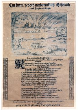
Magdeburk, On
20.05.1631The German poem under the picture contains a dialogue between the fox (Gustav Adolf) and the cat (Tilly). The overturned mousetrap symbolizes the devastated city of Magdeburg, during whose conquest Tilly overate, because he did not swallow an ordinary mouse but rather a ferocious shrew. The cat complains of nausea caused by the shrew in its bowels; the fox responds that these mice will finally bite through the rope which is tying it to the tree, and it will then attack the cat and avenge the mouse. The tied up fox (G.A.) represents the strategic and political situation which prevented the Swedish king from liberating Magdeburg from the siege.
Signature: Sig. C. H. excud.
Autor: Unknown
Original name: Ein kurtz jedoch nachdenklich Gespräch eines Fuchse sund Katzen. Gedruckt, gekwetzscht und den Balg genugsam zerzaust bei der grossen Mauszfallen im Jahr: Heuer wird Magdeburk gerochen.
Katalogová čísla: Collection Český Šternberk, kód: 132/77
This pamphlet deals with the situation after the fall of Magdeburg, and expresses the Protestants' great anger and hatred after the cruel annihilation of Magdeburg by Tilly. The longed-for revenge came about at the Battle of Breitenfeld that same year.
On
20.05.1631King Gustav Adolf of Sweden is leading a bride (i.e. the city of Magdeburg), and a procession is following them. Across from them stand generals Tilly and Pappenheim. Beneath this scene is a short German poem mentioning certain cities (e.g. Ulm, Augsburg, Nuremberg etc.) in various wedding roles. On both sides there is the text of another poem with the words of Tilly, certain soldiers, Magdeburg, Denmark, Turkey, the empire, the Catholic League, Swedes etc. Each of them is speaking ironically, according to their relationship with the Roman-German empire.
Signature: Not available
Autor: Unknown
Original name: Magdeburgish Hochzeitlied, in der Melodey, wie man die Dennemärckische Schlacht singt. Erstlich gedruckt zu Augspurg und da selbsten von einem Papisten auszgesprengt worden, Anno 1631.
Katalogová čísla: Collection Český Šternberk, kód: 148/71
This is a pamphlet about Tilly's conquest of Magdeburg on the 20th of May 1631. Since “Magd“ means a girl or a maid, Tilly was often ridiculed for the conquest of Magdeburg and depicted as the groom at his wedding to a girl (i.e. Magdeburg). The melody to “the Danish battle“ doubtless means the song which at one stage was sung to celebrate Tilly's victory over the Danes at Lutter. Now the same melody was to be sung with a text about Magdeburg, and the soon to follow defeat of Imperial forces at Breitenfeld.
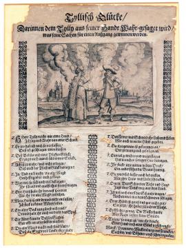
On
01.07.1631 (do 31.12.1631)General Tilly is presenting his open hand to a witch who is predicting another fate for him. A child is standing behind the witch. In the background, Magdeburg is in flames. Beneath the picture is a rhyming dialogue between Tilly and the witch in which Tilly's so-called crimes are primitively described, in particular of course the conquest of Magdeburg. Tilly is trying to justify his actions.
Signature: Not available
Autor: Unknown
Original name: Tyllisch Glücke, Darinnen dem Tylli aus seiner Hand Wahr gesagt wird, was seine Sachen für einen Ausgang gewinnen werden.
Katalogová čísla: Collection Český Šternberk, kód: 149/67
The sheet ridicules Tilly's defeat by the Swedes and the Saxons at Leipzig on the 17th of September 1631, and considers it to be just retribution for the bloody annihilation of Magdeburg.
Werben, On
12.07.1631The picture represents a large Swedish field camp at the confluence of the Elbe and Havel, not far from Werben, which was established by Gustav Adolf on the 12th of July 1631. The arrangement of tents and various other localities in the camp is interesting. In the background we can see the confluence of both of the mentioned rivers and the small fortified town of Werben. Tilly's troops are in the foreground. At the bottom on the left, there is a rectangle with the legend A-I.
Signature: Not available
Autor: Unknown
Original name: Her Coninkl. Sweetshe Velt-leger by Werben, anno 1631.
Katalogová čísla: Collection Český Šternberk, kód: 133/238
After the conquest of Magdeburg by Tilly on the 20th of May 1631, the Imperial forces stayed in the vicinity of the devastated town for some time, while Gustav Adolf remained in Brandenburg with his troops where he occupied some strategically important places in order to ensure a connection to his bases. Because it still had not been decided whether John George I. Elector of Saxony would remain an ally on the Imperial side or move to the Swedish side after this significant event, Gustav Adolf did not decide on immediate action against Tilly but instead waited in a fixed camp which he had established at Werben at the beginning of July 1631. On the 22nd of July, a significant part of Tilly's army approached the Werben camp. Over the following days there were several clashes and skirmishes between the Swedes and the Imperial forces which caused bloody losses on both sides, but did not bring about a decisive victory. As time went on, the Imperial forces began to suffer from hunger and a noticeable lack of drinking water, as the water in the Elbe was unusable due to large numbers of corpses from Magdeburg floating in it. Tilly was therefore forced to give the command to retreat from Werben on the 29th of July; this was also due to the fact that the convenient strategic position of the Swedes ruled out a favourable final outcome of the battle for the Imperial forces.
Werben, On
12.07.1631This copperplate is identical to the print mentioned on the previous page under no. 133/238, which is labelled in Dutch, while sheet no. 134/262 is labelled with a German-Latin inscription.
Signature: Not available
Autor: Unknown
Original name: Eigentliche Abbildung des königlichen Schwedischen Veldlägers bey Werben an der Elbe. Anno 1631. Werbena cum castris Svecorum.
Katalogová čísla: Collection Český Šternberk, kód: 134/262
After the conquest of Magdeburg by Tilly on the 20th of May 1631, the Imperial forces stayed in the vicinity of the devastated town for some time, while Gustav Adolf remained in Brandenburg with his troops where he occupied some strategically important places in order to ensure a connection to his bases. Because it still had not been decided whether John George I. Elector of Saxony would remain an ally on the Imperial side or move to the Swedish side after this significant event, Gustav Adolf did not decide on immediate action against Tilly but instead waited in a fixed camp which he had established at Werben at the beginning of July 1631. On the 22nd of July, a significant part of Tilly's army approached the Werben camp. Over the following days there were several clashes and skirmishes between the Swedes and Imperial forces which caused bloody losses on both sides, but did not bring about a decisive victory. As time went on, the Imperial forces began to suffer from hunger and a noticeable lack of drinking water, as the water in the Elbe was unusable due to large numbers of corpses from Magdeburg floating in it. Tilly was therefore forced to give the command to retreat from Werben on the 29th of July; this was also due to the fact that the convenient strategic position of the Swedes ruled out a favourable final outcome of the battle for the Imperial forces.
Tangermünde, On
30.07.1631The picture shows a view of the town of Tangermünde, which lies on the Elbe, approximately 100km west of Berlin, on a gentle hill. The Tanger river, flowing into the Elbe, is drawn on the print. In the sky there is a blank heraldic shield. In the foreground there is a fortified military camp on the bank of the Elbe. On the river, two ships are sailing.
Signature: Not available
Autor: Unknown
Original name: Tangermünd.
Katalogová čísla: Collection Český Šternberk, kód: 135/223
In the period preceding the Battle of Breitenfeld, which took place on the 17th of September 1631, both of the opposing armies - those of Tilly and Gustav Adolf - operated in Brandenburg along the middle of the river Elbe. Tilly arrived with his army in Tangermünde on the 30th of July 1631, established a camp there (as is evident from the picture) and remained here until the 12th of August; then he moved off in the direction of Saxony, mainly due to supply reasons as Saxony had not yet been affected by looting troops, as almost all the other German countries were. The entire period preceding the Battle of Breitenfeld was used for smaller supply expeditions by both the Imperial League troops and the Swedes. At that time there were often clashes between both sides' cavalry divisions, which either monitored the procurement of food, or attempted to thwart the same efforts by enemy expeditions. We must not forget that looting by the Imperial divisions in Saxony to a large extent influenced the decision of John George I. Elector to join the Battle of Breitenfeld on the Swedish side.
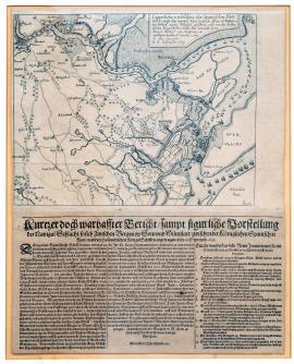
On
13.09.1631The picture illustrates the Dutch territory at the mouth of the Scheldt. There are many different warships on the river. The above-quoted German text with the legend A-B is located below the upper edge of the print. Under the picture there is a three-verse German text, which describes the course of the naval battle and mentions several military inventions discovered by a certain monastic person in Brussels. These inventions (1-14) apparently helped the Dutch to victory.
Signature: Not available
Autor: Unknown
Original name: Eigentliche Vorbildung der Spanischen Flott, welche unter dem Comando des Herrn Grafen Johann von Nassau etc. von Anttorff nachher Wilmstatt gefahren und von den holländischen Kriegsschiffen under dem Commando Herrn Heinrich Prinzen von Oragnien etc. geschlagen worden Anno 1631 den 13. September.
Katalogová čísla: Collection Český Šternberk, kód: 137/437
In the long war between the Netherlands and Spain, there was a turnaround in favour of the Dutch due to the personal military and diplomatic skills of Frederick Henry Prince of Orange, who around the year 1630 defeated the Spanish on several occasions both on dry land and at sea. The illustrated naval battle between the Spanish fleet under Count John of Nassau, who was originally on the Protestant side and was one of the relatives of Frederick Henry prince of Orange but converted to Catholicism and held various positions in the Habsburg and Spanish armies, and the Dutch fleet commanded by Frederick Henry Prince of Orange, took place on the 13th of September 1631 at the mouth of the Scheldt, and ended in the complete defeat of the Spanish.
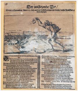
Breitenfeld, On
16.09.1631The print depicts general Tilly's messenger who is marching to Frankfurt-on-Mohan. He's holding a lance and waving a hat with the other; he has luggage tied to his back and an Imperial emblem with an eagle on his chest. The goal of his journey – Frankfurt-on-Mohan – is in the background. Beneath the illustrated scene there is a long German poem strongly describing daring and confidence in the victory of Tilly's army, which is preparing to fight against the troops of Gustav Adolf of Sweden and John George Elector of Saxony. The Elector of Saxony, in particular, is shown very frequently, as he only decided to fight on the Swedish side shortly before the Battle of Breitenfeld.
Signature: Not available
Autor: Unknown
Original name: Der jauchtzende Bot, so den 6. Septemberis Anno 1631 früh aus dem Tillyschen Läger vor Leipzig nachher Frankfurt am Mayn abgangen. Gedruckt im Jahr MDCXXXII.
Katalogová čísla: Collection Český Šternberk, kód: 145/76
This is a promotional leaflet ridiculing Tilly and his troops after the Battle of Leipzig (of Breitenfeld) on the 17th of September 1631. The rejoicing messenger, already delivering a report on the certain victory of the Imperial troops in advance (before the battle), is supposed to represent the confidence and pride of the Imperial League army before the big clash at Leipzig, and at the same time make the contrast with Tilly's crushing defeat even starker. In this way, the Protestants tried to capitalize on their victory and gain as much political prestige as possible. The fact that the sheet was printed a year after the Battle of Breitenfeld shows that the author of the print already knew the result of the battle, and invented and added the entire tale involving the messenger for promotional reasons.
Breitenfeld, On
17.09.1631The picture has been drawn in a relatively primitive and simple way. It represents the position of both of the opponents' troops before the battle at Breitenfeld near Leipzig. The bottom of the picture shows a village with a church tower and a long ditch with a row of trees planted beside it; a little further on the left is another village. The destination at the end of the drawn paths is always labelled with an inscription. At the bottom on the right there is an orientation compass. In addition to the clamped military formations there are also many individual figures, horsemen, firing cannons, vehicles etc.
Signature: Not available
Autor: Unknown
Original name: Schlachtordnung I. May. in Schweden und Churf. Durchl. zu Sachsen und dann des Grafen von Tilly bey Leipzig 1631.
Katalogová čísla: Collection Český Šternberk, kód: 138/167
The Battle of Breitenfeld (also known as “the Battle of Leipzig“) which took place on the 17th of September 1631, was one of the most significant and by its extent one of the largest battles of the Thirty Years' War. A direct result of it was a new distribution of power in the conflict. For various strategic and political reasons, Gustav Adolf of Sweden needed a lot of time before he decided on a direct, decisive battle against Tilly's army, which up to now had not suffered any significant defeat. One of the main incentives for the Protestants was the desire for revenge for the looting of Magdeburg. John George I. Elector of Saxony hesitated for a long time before openly opposing the Emperor, and this decision was actually caused by Tilly's lack of diplomatic skill, as he advanced with his hungry army though Saxon territory which had up to that point not been affected by the war, and his divisions looted whenever they could. This fact, and the terrible fate of Magdeburg which was actually Tilly's work, strengthened the decision of the Elector of Saxony to join the Swedish side. In this way he became a needle on a scale which Tilly could no longer balance. During the clash between the two armies, over 30,000 men on each side stood facing each other (i.e. a total of over 60,000 men). At the beginning of the battle, the Saxons were defeated by Fürstenberg on the left wing, and their formations fell apart. The brilliant tactic used by Gustav Adolf II. King of Sweden, however, managed to balance this initial defeat. The Swedish infantry achieved unexpected successes in this battle. The experienced general Pappenheim (after whom the saying: “We know our own Pappenheimers!“ is still used today) carried out sudden attacks on the left wing of the Imperial forces, but these were fruitless against the flexibly operating Swedes. The Imperial League troops suffered a crushing defeat. It was mainly due to the Swedish king's tactical innovations – strong infantry formations, mobile artillery and the support of cavalry formations by infantry fire surprised Tilly, who had made several fundamental errors in his own battle plan.
Breitenfeld, On
17.09.1631The copperplate is divided into two parts, of which the upper part depicts the positions of both of the opposing armies, the Imperial League and the Swedish-Saxon, between the Battle of Breitenfeld on the 17th of September 1631. At the bottom there is a picture of the battle in full swing; the Imperial-Bavarian divisions are in disarray and are retreating and fleeing. On both of the pictures, the village of Breitenfeld is at the bottom on the right. The whole copperplate is framed by a fine baroque frame with a small shield in the top centre, in which the number XLIV is written. The above-quoted Latin text is located on the decorative shield between both of the illustrated scenes.
Signature: Not available
Autor: Unknown
Original name: Diatyposis praelii prope Lipsiam comissi.
Katalogová čísla: Collection Český Šternberk, kód: 139/314
The Battle of Breitenfeld (also known as “the Battle of Leipzig“) which took place on the 17th of September 1631, was one of the most significant and by its extent one of the largest battles of the Thirty Years' War. A direct result of it was a new distribution of power in the conflict. For various strategic and political reasons, Gustav Adolf of Sweden needed a lot of time before he decided on a direct, decisive battle against Tilly's army, which up to now had not suffered any significant defeat. One of the main incentives for the Protestants was the desire for revenge for the looting of Magdeburg. John George I. Elector of Saxony hesitated for a long time before openly opposing the Emperor, and this decision was actually caused by Tilly's lack of diplomatic skill, as he advanced with his hungry army though Saxon territory which had up to that point not been affected by the war, and his divisions looted whenever they could. This fact, and the terrible fate of Magdeburg which was actually Tilly's work, strengthened the decision of the Elector of Saxony to join the Swedish side. In this way he became a needle on a scale which Tilly could no longer balance. During the clash between the two armies, over 30,000 men on each side stood facing each other (i.e. a total of over 60,000 men). At the beginning of the battle, the Saxons were defeated by Fürstenberg on the left wing, and their formations fell apart. The brilliant tactic used by Gustav Adolf II. King of Sweden, however, managed to balance this initial defeat. The Swedish infantry achieved unexpected successes in this battle. The experienced general Pappenheim (after whom the saying: “We know our own Pappenheimers!“ is still used today) carried out sudden attacks on the left wing of the Imperial forces, but these were fruitless against the flexibly operating Swedes. The defeat of the Imperial League troops was crushing. It was mainly due to the Swedish king's tactical innovations – strong infantry formations, mobile artillery and the support of cavalry formations by infantry fire surprised Tilly, who had made several fundamental errors in his own battle plan.
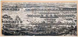
Breitenfeld, On
17.09.1631This is a fragment of a large copperplate, engraved á la Merian but unsigned. In the foreground of the military scene there is the village of Podelwitz, and an unnamed river. The left third of the picture shows the path to Wittenberg and Leipzig. Beside the path labelled with the letter “K“ is an illustration of general Tilly with his adjutant; on the right is King Gustav Adolf of Sweden with two horsemen. The above-quoted Latin text is located above the illustrated scene.
Signature: Not available
Autor: Unknown
Original name: Delineatio aciei regiae sveticae et electoralis Saxoniae, hisque opositae caesarae ac ligisticae sub ductu comitis Tilii una cum accurata desigantione ….rum alarum et cohortium utriusque partis, quo pacto ille ante conflictum iuxta Lipsiam ex adverso constiterint subiecta ipsius praelii icone.
Katalogová čísla: Collection Český Šternberk, kód: 140/326
The Battle of Breitenfeld (also known as “the Battle of Leipzig“) which took place on the 17th of September 1631, was one of the most significant and by its extent one of the largest battles of the Thirty Years' War. A direct result of it was a new distribution of power in the conflict. For various strategic and political reasons, Gustav Adolf of Sweden needed a lot of time before he decided on a direct, decisive battle against Tilly's army, which up to now had not suffered any significant defeat. One of the main incentives for the Protestants was the desire for revenge for the looting of Magdeburg. John George I. Elector of Saxony hesitated for a long time before openly opposing the Emperor, and this decision was actually caused by Tilly's lack of diplomatic skill, as he advanced with his hungry army though Saxon territory which had up to that point not been affected by the war, and his divisions looted whenever they could. This fact, and the terrible fate of Magdeburg which was actually the Tilly's work, strengthened the decision of the Elector of Saxony to join the Swedish side. In this way he became a needle on a scale which Tilly could no longer balance. During the clash between the two armies, over 30,000 men on each side stood facing each other (i.e. a total of over 60,000 men). At the beginning of the battle, the Saxons were defeated by Fürstenberg on the left wing, and their formations fell apart. The brilliant tactic used by Gustav Adolf II. King of Sweden, however, managed to balance this initial defeat. The Swedish infantry achieved unexpected successes in this battle. The experienced general Pappenheim (after whom the saying: “We know our own Pappenheimers!“ is still used today) carried out sudden attacks on the left wing of the Imperial forces, but these were fruitless against the flexibly operating Swedes. The Imperial League troops suffered a crushing defeat. It was mainly due to the Swedish king's tactical innovations – strong infantry formations, mobile artillery and support of cavalry formations by infantry fire surprised Tilly, who had made several fundamental errors in his own battle plan.
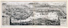
Breitenfeld, On
17.09.1631The engraving represents a large prospectus of the Battle of Breitenfeld (of Leipzig). On the left-hand side the battle is already approaching its peak, but the situation on the right-hand side is not yet so advanced. In the foreground is a village with a windmill, a small church and groups of trees. In the foreground on the right there are several military emblems, and a little to the left there is an orientation compass. The quoted text is located in the rectangle at the bottom on the right; on the left there is another rectangle with the legend A-M.
Signature: Not available
Autor: Unknown
Original name: La Battaglia di Lipsia Fragli Exerciti imperiale e della lega Cattolica contro quelli del Re Gustavo Adolfo di Suecia e dell Elettore di Sassonia seguita alli 17. di Setembre 1631.
Katalogová čísla: Collection Český Šternberk, kód: 141/473
The Battle of Breitenfeld (also known as “the Battle of Leipzig“) which took place on the 17th of September 1631, was one of the most significant and by its extent one of the largest battles of the Thirty Years' War. A direct result of it was a new distribution of power in the conflict. For various strategic and political reasons, Gustav Adolf of Sweden needed a lot of time before he decided on a direct, decisive battle against Tilly's army, which up to now had not suffered any significant defeat. One of the main incentives for the Protestants was the desire for revenge for the looting of Magdeburg. John George I. Elector of Saxony hesitated for a long time before openly opposing the Emperor, and this decision was actually caused by Tilly's lack of diplomatic skill, as he advanced with his hungry army though Saxon territory which had up to that point not been affected by the war, and his divisions looted whenever they could. This fact, and the terrible fate of Magdeburg which was actually Tilly's work, strengthened the decision of the Elector of Saxony to join the Swedish side. In this way he became a needle on a scale which Tilly could no longer balance. During the clash between the two armies, over 30,000 men on each side stood facing each other (i.e. a total of over 60,000 men). At the beginning of the battle, the Saxons were defeated by Fürstenberg on the left wing, and their formations fell apart. The brilliant tactic used by Gustav Adolf II. King of Sweden, however, managed to balance this initial defeat. The Swedish infantry achieved unexpected successes in this battle. The experienced general Pappenheim (after whom the saying: “We know our own Pappenheimers!“ is still used today) carried out sudden attacks on the left wing of the Imperial forces, but these were fruitless against the flexibly operating Swedes. The Imperial League troops suffered a crushing defeat. It was mainly due to the Swedish king's tactical innovations – strong infantry formations, mobile artillery and the support of cavalry formations by infantry fire surprised Tilly, who had made several fundamental errors in his own battle plan.
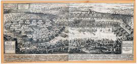
Breitenfeld, On
17.09.1631This is a large and detailed picture of the Battle of Breitenfeld. The above-quoted text is located on the right. The entire area of the picture is filled with battle scenes with cannons, banners, cannonballs, kegs etc. An unnamed stream flows along the edge. The most intense battle rages on the left, beneath a hillock with a gallows across which many soldiers are fleeing.
On the left at the top there is an incoiled vignette with battle slogans: “Gott mit uns“ (i.e. Swedish) and “Jesus Maria“ (i.e. Imperial). Under the picture are the legends A-X and 1-99.
Signature: Not available
Autor: Hanson Oluf, švédský kreslíř plánů a bitev
Original name: Praelii inter sereniss. Svecor. regem et Saxoniae elektorem nec non catholicae ligae generalem cm. a Tilly VII. september anni MDCXXXI prope Lipsam comissi et subsecutae exercitus catholici stragis fugaeque ad omnem posteritatem memorabilis cum instructae aciei typo delineatio, quam iussu et auspiciis regis supremus castrorum metator et architectus Oluv Hanson delineavit.
Katalogová čísla: Collection Český Šternberk, kód: 142/217
The Battle of Breitenfeld (also known as “the Battle of Leipzig“) which took place on the 17th of September 1631, was one of the most significant and by its extent one of the largest battles of the Thirty Years' War. A direct result of it was a new distribution of power in the conflict. For various strategic and political reasons, Gustav Adolf of Sweden needed a lot of time before he decided on a direct, decisive battle against Tilly's army, which up to now had not suffered any significant defeat. One of the main incentives for the Protestants was the desire for revenge for the looting of Magdeburg. John George I. Elector of Saxony hesitated for a long time before openly opposing the Emperor, and this decision was actually caused by Tilly's lack of diplomatic skill, as he advanced with his hungry army though Saxon territory which had up to that point not been affected by the war, and his divisions looted whenever they could. This fact, and the terrible fate of Magdeburg which was actually Tilly's work, strengthened the decision of the Elector of Saxony to join the Swedish side. In this way he became a needle on a scale which Tilly could no longer balance. During the clash between the two armies, over 30,000 men on each side stood facing each other (i.e. a total of over 60,000 men). At the beginning of the battle, the Saxons were defeated by Fürstenberg on the left wing, and their formations fell apart. The brilliant tactic used by Gustav Adolf II. King of Sweden, however, managed to balance this initial defeat. The Swedish infantry achieved unexpected successes in this battle. The experienced general Pappenheim (after whom the saying: “We know our own Pappenheimers!“ is still used today) carried out sudden attacks on the left wing of the Imperial forces, but these were fruitless against the flexibly operating Swedes. The Imperial League troops suffered a crushing defeat. It was mainly due to the Swedish king's tactical innovations – strong infantry formations, mobile artillery and the support of cavalry formations by infantry fire surprised Tilly, who had made several fundamental errors in his own battle plan.

Breitenfeld, On
17.09.1631The engraving represents a large prospectus of the Battle of Breitenfeld (of Leipzig). On the left-hand side the battle is already approaching its peak, but the situation on the right-hand side is not yet so advanced. In the foreground is a village with a windmill, a small church and groups of trees. In the foreground on the right there are several military emblems, and a little to the left there is an orientation compass. The quoted text is located in the rectangle at the bottom on the right; on the left there is another rectangle with the legend A-M.
Signature: Not available
Autor: Unknown
Original name: La Battaglia di Lipsia Fragli Exerciti imperiale e della lega Cattolica contro quelli del Re Gustavo Adolfo di Suecia e dell Elettore di Sassonia seguita alli 17. di Setembre 1631.
Katalogová čísla: Collection Český Šternberk, kód: 143/232
The Battle of Breitenfeld (also known as “the Battle of Leipzig“) which took place on the 17th of September 1631, was one of the most significant and by its extent one of the largest battles of the Thirty Years' War. A direct result of it was a new distribution of power in the conflict. For various strategic and political reasons, Gustav Adolf of Sweden needed a lot of time before he decided on a direct, decisive battle against Tilly's army, which up to now had not suffered any significant defeat. One of the main incentives for the Protestants was the desire for revenge for the looting of Magdeburg. John George I. Elector of Saxony hesitated for a long time before openly opposing the Emperor, and this decision was actually caused by Tilly's lack of diplomatic skill, as he advanced with his hungry army though Saxon territory which had up to that point not been affected by the war, and his divisions looted whenever they could. This fact, and the terrible fate of Magdeburg which was actually Tilly's work, strengthened the decision of the Elector of Saxony to join the Swedish side. In this way he became a needle on a scale which Tilly could no longer balance. During the clash between the two armies, over 30,000 men on each side stood facing each other (i.e. a total of over 60,000 men). At the beginning of the battle, the Saxons were defeated by Fürstenberg on the left wing, and their formations fell apart. The brilliant tactic used by Gustav Adolf II. King of Sweden, however, managed to balance this initial defeat. The Swedish infantry achieved unexpected successes in this battle. The experienced general Pappenheim (after whom the saying: “We know our own Pappenheimers!“ is still used today) carried out sudden attacks on the left wing of the Imperial forces, but these were fruitless against the flexibly operating Swedes. The Imperial League troops suffered a crushing defeat. It was mainly due to the Swedish king's tactical innovations – strong infantry formations, mobile artillery and the support of cavalry formations by infantry fire surprised Tilly, who had made several fundamental errors in his own battle plan.
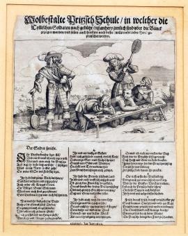
On
17.09.1631The picture shows 3 of Tilly's soldiers kneeling in front of a bench; 2 Swedish mercenaries are standing behind them and beating them mercilessly with large bats. Playing cards and various delicacies lie on the bench. Under the bench there is a mousetrap and a brush. In the background is an emblem of the Battle of Breitenfeld. Beneath this scene there is a 9-verse poem in which the beating Swedish soldiers describe the crimes perpetrated by Tilly's army, thus justifying their own actions.
Signature: Not available
Autor: Unknown
Original name: Wohlbestallte Pritzsch Schule, in welcher die Tyllischen Soldaten nach Gebühr, bisz anhero zimlich sind über die Bank gezogen worden und sollen auch hinführe noch besser (wills der liebe Herr) gepritzsched werden. Gedruckt im Jahr 1631.
Katalogová čísla: Collection Český Šternberk, kód: 146/73
This Protestant pamphlet satirizees Tilly's defeat at Breitenfeld on the 17th of September 1631 and shows the hatred and anger of the Swedes towards the Imperial League troops, whose main crime was the cruel annihilation of Magdeburg. The delicacies on the bench sarcastically symbolize the bitter defeat of the Imperial forces by the Swedes at Breitenfeld and the moustrap represents the conquest of Magdeburg where Tilly “sat on the pork fat“ for the Protestants and fell into the trap, despite his bloody conquest of the town. Similarly illustrated similes can often also be found in other graphic art in our collection.
On
17.09.1631This is an extensive pictorial riddle (rebus), which is located under the inscription:
“Als man zählt tausend sechshundert einunddreisig Jahr, am Tag Regina das ist wahr, ward Magdeburg hunderfältig gerochen, und mancher Pfaffenknecht erstochen, usw.“
“When we counted the one thousand six hundred and thirty first year, on the day of the Queen, it is true, Magdeburg was avenged hundredfold and many a parish priest's servant was stabbed, etc.“ The almost completely deciphered text of the rebus is quoted on the reverse of this copperplate.
Signature: Not available
Autor: Unknown
Original name: Des Tilly Haushaltung
Katalogová čísla: Collection Český Šternberk, kód: 147/140
The print contains a satirical rebus dealing with Tilly's defeat at Breitenfeld on the 17th of September 1631. The leaflet mocks the defeated general and describes his defeat as punishment for the conquered and plundered Mandeburg. The term “Haushaltung“ is not particularly convincing. However, Zíbrt uses this to explain the engraved detail of a man holding a tilting house. Maybe the right term should be: “Umfall“ or “Unfall“, i.e. fall, an accident or an injury. The tilting house could be identified by this term, which would also convey the meaning of the subject more accurately. However, “Haushaltung“, i.e. household, can be interpreted in this context as “general living conditions“ which would also convey the meaning of the rebus.
On
17.09.1631The copperplate is composed of six pictorial sections:
A. Tilly is depicted in armour with a raised sword in his right hand as the yet undefeated, confident hero. Behind him are the Brandenburg eagle and the Swedish lion, and he obviously has no fear of them.
B. Tilly is on a horse, with his bride (i.e. Magdeburg) and a soldier with his hand raised in the saddle behind him. In the background is the burning city of Magdeburg, and troops.
C. A fight between soldiers at the lunch table. This represents Tilly's defeat at Breitenfeld on the 17th of September 1631, which in Protestant pamphlets is very often compared to a banquet put on for Tilly by King Gustav Adolf of Sweden and the Elector of Saxony.
D. Tilly is sitting unhappily on the ground in a landscape; there are flies buzzing around his head (i.e. depressing thoughts which are troubling him) and in the background there is a battlefield littered with corpses. This symbolizes the Tilly's desperate situation after the great defeat at Leipzig.
E. Tilly is sitting in a church beside a priest, making his confession. A person representing desperation is handing Tilly a knife and rope so that he can commit suicide.
F. In front of the church gates stands a monk who is offering Tilly a monk's frock. This represents Tilly intending to join a convent in desperation. A long German poem explaining the illustrated scenes follows.
Signature: Not available
Autor: Unknown
Original name: Tillius poenitens, Das ist Tyllische Busz und darauf erfolgte Absolution nach allen dreyen päbstischen Stücken, als der Re. Beicht und Genugthuung gethan und empfangen nach erlittener leipzigischen Niederlage. Gedruckt im Jahre MDCXXXII.
Katalogová čísla: Collection Český Šternberk, kód: 150/132
The print mocks Tilly's defeat at Breitenfeld on the 17th of September 1631. The poem discusses practically all of general Tilly's military career, from the battle on White Mountain to the defeat at Breitenfeld – in an ironic light, of course. Great emphasis is placed (as it always was during that year) on the cruel conquest and destruction of Magdeburg, which was the main reason for the Protestants' hatred of Imperial and League troops. There is also detailed elaboration on why the general is troubled by a guilty conscience which prompted him to make a confession. The author of the print infers only two acceptable conclusions for general Tilly in this situation: entry into a convent, or suicide.
On
17.09.1631On the picture is general Tilly sitting on a lion in the skin of a donkey, with long ears. Tilly is holding a tattered branch in his hand, and has a large hat on his head. In front of him, the Pope sits on a throne with a triple cross in his hand and a tiara on his head. Nearby, between the two, stands a high-ranking church dignitary, apparently a cardinal, who is holding a warhorse by the reins and offering it to Tilly. In the background, on the left, stands a verger. Beneath this scene is a rhyming text with a dialogue between the Pope and Tilly, numbering 42 verses.
Signature: Not available
Autor: Unknown
Original name: Tyllisch Klostergelübde.
Katalogová čísla: Collection Český Šternberk, kód: 151/126
This is a Protestant pamphlet which deals with general Tilly's dismal position after the Battle of Breitenfeld, using sarcasm. The dialogue expresses Tilly's desperation and helplessness to take up arms again and fight against Gustav Adolf, which the Pope is exhorting him to do with various arguments. Tilly refuses the Pope's encouragement and declares that he wants to take shelter in monastic seclusion. The lion dressed in a donkey's skin is probably supposed to represent the actual nature of Tilly's legendary victorious command which in the end brought about the defeat at Breitenfeld with its stupidity. Perhaps “Tiilly's stupidity“ means his inopportune campaign in Saxon territory, together with his troops' extensive plundering which at the last minute convinced John George I. Elector of Saxony to openly oppose the Imperial forces.
On
17.09.1631Tilly, dressed in armour, is lying sick on a bed; the expression on his face shows severe pain. Beside the bed is a table with a glove, a helmet and marshal's staff on it. In the background there is a window covered by a curtain. On the tablecloth there is an inscription (translated): “An honest day's work for an honest day's pay!“ On the bolster there is an inscription: “Lord Tilly, how come you're so calm?“ An extensive German poem follows, in which Tilly laments his fate, which is punishment for his crimes in Magdeburg. In another the author warns all other offenders of God's vengeance.
Signature: Not available
Autor: Unknown
Original name: Tillysche Deposition Nahe bey der hohen Schul in Leipzig, Depositore Langen Fritzio.
O langer Fritz verzeih Dirs Gott,
dass Du mich fast geschlagen Todt!“
Anno Wie MagDenbVrg Von Gott War geroChen.
Katalogová čísla: Collection Český Šternberk, kód: 152/68
This is a pamphlet published by Protestants, which mocks the defeat of the Imperial League troops under the command of general Tilly on the 17th of September 1631 at Breitenfeld, not far from Leipzig. The author of the print is also mocking the injuries that Tilly suffered in that battle. During the biggest commotion in the battle, Tilly suddenly met a certain Swedish captain who was nicknamed: “der lange Fritz“, i.e. “Long Frederick”, and who called on Tilly to surrender immediately. Tilly refused, whereupon Long Frederick hit him in the neck with the butt of a cavalry carbine, causing him a painful bruise. At that moment, however, Duke Rudolf of Saxony-Lauenburg rushed to Tilly's aid and shot Long Frederick through the head.
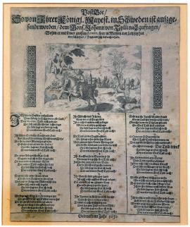
On
17.09.1631The picture shows a postal messenger cantering on a horse and blowing a French horn. He's riding through a rocky and forested landscape, in the background of which there is a small church and a body of water with a ship. Behind the rider on the right, there is a man holding a long staff. Under this illustrated scene there is a German poem in which the messenger constantly asks peasants, priests, monks, nuns and all other passers-by where Tilly disappeared with his great army. Among the generals mentioned in the verses, there are also references to Aldrigen and Götz.
Signature: Not available
Autor: Unknown
Original name: Post Bor, so von Ihrer Königl. Mayest. in Schweden ist auszgesandt worden, dem Mons. Johann von Tylli nach zu fragen, wohin er mit seiner grossen Armée, so er in Meyssen vor Leipzig hat bey sich gehabe, so eylends sich verkrochen habe. Gedruckt im Jahr 1631.
Katalogová čísla: Collection Český Šternberk, kód: 153/57
The leaflet, published by Protestants, ridicules Tilly and his army after the defeat at Breitenfeld on the 17th of September 1631. Given that fact that the Swedes' and Saxons' victory over the Imperial League troops meant a turnaround in the distribution of power between the warring parties in favour of the Protestants, this event was also extensively used for promotional purposes. This is why we see an extraordinary amount of graphic art, which tries to use all resources – both pictorial and verbal – to emphasize the significance of the victory at Leipzig and at the same time humiliate the defeated opponent. The political-military situation in the Imperial camp, which was a result of this Battle of Breitenfeld, forced the Emperor to call the experienced Waldstein into his services again (the so-called second generalate).
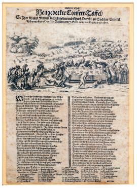
On
17.09.1631The picture, which is very delicately and carefully made, shows a lain table thronged by a large number of wounded and maimed soldiers. Beside the table on the right stands Gustav Adolf of Sweden, beating an Imperial soldier over the head with a staff. A little further away stands John George Elector of Saxony, who with a raised forefinger warns the pushing soldiers not to eat the tempting dishes. In the background we can see Tilly's army on the run, and numerous dead and wounded mercenaries. Under the picture there is a poem describing, in detail, the course of the banquet prepared for Tilly and his famous army. Naturally, the tone of the poem is sarcastic, especially when it deals with Tilly's actions at the “banquet of Breitenfeld”. Beneath the poem is a detailed menu listing all sorts of delicacies that have been prepared for Tilly.
Signature: Not available
Autor: Unknown
Original name: Neugedeckte Confectt-Taffel, So Ihre Königl. Mayest. in Schweden und Churf. Durchl. zu Sachsen General Tillen und seinen Confect-Näschern, den 7. Sept. 1631 vor Leipzig angerichtet.
Katalogová čísla: Collection Český Šternberk, kód: 154/3
The leaflet, published by Protestants, uses both pictures and words to mock the defeat of Tilly and his army at Breitenfeld on the 17th of September 1631. It is interesting to note that the Battle of Breitenfeld is always (mockingly) compared in graphic illustrations from this period to a great banquet with selected delicacies prepared by Gustav Adolf and John George of Saxony for Tilly and his troops, at which the Imperial forces gorged themselves so much that they were incapable of any more warfare.
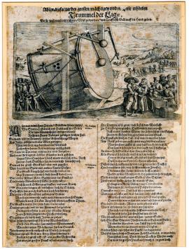
On
17.09.1631This is a picture of an enormous drum, which is fixed askew in a scaffolding construction which is similarly tilted. In the background there are several people using ropes to move large drumsticks and beat the drum with them. In front of the drum is the devil, dressed in an officer's uniform and wearing a large hat; he is accepting money offered to him by priests with Jesuit birettas on their heads. One of the Jesuits is persuading the devil not to be embarrassed to take the money. In the background, crowds of people are flocking to be recruited into the army. Beneath this picture there is a poem which harshly condemns the manner in which armies were recruited and armed in the Thirty Years' War.
Signature: Not available
Autor: Unknown
Original name: Abcontrafactur der grossen, mächtigen und noch nie erhörten Trummel der Ligae, so sie weit und breit rühren Volck zu werben und Teufflisch Geld auff die Hand geben.
Katalogová čísla: Collection Český Šternberk, kód: 155/135
This anti-Catholic pamphlet was apparently issued after the Battle of Breitenfeld on the 17th of September 1631, after which the defeated Imperial League side had a great demand for troops. It can be concluded that this engraving actually directly alludes, with its satirical theme, to the manner in which Waldstein, at the time of his so-called second generalate, recruited troops to create very sizeable armies.
The verse beneath the picture initially describes the old way of recruiting troops for overseas expeditions, when people were summoned using church bells. At this period in time, however, this method no longer worked since the bell in Breitenfeld had fallen to the ground and broken, and besides bells were being melted down and used to manufacture cannons (just like in the wars in 1914-1918 and 1939-1945!). The League was therefore forced to use a large drum instead of bells for recruitment purposes, and great promises to attract people to the places where recruitment took place. The money needed to establish and maintain the armies had to be either acquired as haul during conquests, or extorted as taxes from the population or subjects in occupied territories. In the print, this immoral and exploitative activity is carried out by the devil.
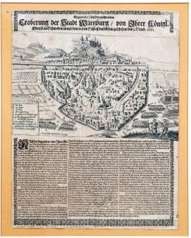
On
08.10.1631The picture is relatively primitively drawn and represents the conquest of Würzburg-on-Mohan by the Swedes. At the top is the horizontally drawn flow of the Mohan; above it lies the castle which is being conquered by Swedish troops. Würzburg is drawn in detail in the shape of a triangle; the Swedes have already entered the town. On the right there are several Swedish divisions, and in the foreground there are two musketeers. At the bottom on the left, there is the legend: A-I. Several verses beneath the picture deal with the course of the battle for Würzburg. The above-quoted inscription is located above the picture.
Signature: Jiří Köler, Norimberk
Autor: Köler Georg, rytec v Norimberku
Original name: Eygentlicher Abrisz der geschwinden Eroberung der Stadt Würtzburg von Ihrer Königl. Majest. in Schweden sampt dem vesten Schloss daselbsten geschehen den 8. Octob. 1631.
Katalogová čísla: Collection Český Šternberk, kód: 156/233
After the significant victory over Tilly at Breitenfeld on the 17th of September 1631, some indecisiveness arose in the Protestant camp about how to proceed. The path to Vienna was now open. John George I. Elector of Saxony recommended a campaign in Bohemia, in order to prevent the Emperor from building a new army. In the end, Gustav Adolf decided to advance to the West, in the direction of Halle and Erfurt to Würzburg. The local bishop, who ruled the town, fled before the Swedes. After several cannon volleys fired by the Swedes, the town surrendered by agreement. Wealthy citizens and traders hid in the castle with their goods; the castle garrison refused to surrender to the Swedes voluntarily. There was a short siege; the first attack by the conquerors was repelled but the two attacks which followed broke the defenders' resistance. 1,500 men in the garrison were slaughtered, many civilians also lost their lives, and the Swedes killed 20 priests in the castle cathedral. The seized haul was extensive and varied, and included a large amount of cash.
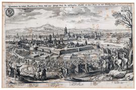
Frankfurt nad Mohanem, On
17.11.1631The picture shows the city of Frankfurt-on-Mohan. In the background there is a relatively high mountain range and in the foreground we can see Swedish troops, led by King Gustav Adolf, advancing on the city. On the right there are a number of trees and two trumpeters on horses, and in the top left-hand corner is the city emblem with a laurel branch around it. Below is the legend 1-22.
Signature: Not available
Autor: Unknown
Original name: Contrafactur der Statt Franckfurt am Mayn und wie königl. May. zu Schweden daselbst mit ihrer Armee ein und durchgezogen, den 17. November 1631.
Katalogová čísla: Collection Český Šternberk, kód: 157/253
After his piercing victory at Breitenfeld, Gustav Adolf of Sweden advanced with his army to the west and occupied several important cities, among them Frakfurt-on-Mohan. Initially, the city council did not want to submit to the conditions offered by the Swedes and which had already been interpreted for them by the royal messenger Philipp Reinhard of Solms the day before the conquest (i.e. the 16th of November). Only on the following day did the city council reach the conclusion that there is no point opposing the dominant Swedish forces; it accepted the Swedes' capitulation conditions and handed the city over to them. Gustav Adolf occupied the city, but immediately set off on another march.
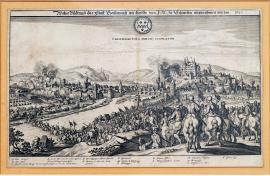
Bad Kreuznach, On
01.12.1631The print shows the town of Kreuznach, lying on the river Nahe (the right tributary of the Rhine), approximately 70 km south-west of Frankfurt-on-Mohan. The Swedish cavalry is fording this river. On the right, on a hillock, lies Kreuznach castle. The town extends over both banks of the Nahe, and is engulfed in flames. In the foreground, on the right, there are horsemen with banners. In the skies is the town emblem with the inscription: “Crucenacum a Svecis occulatur.“ (this should be “occupatur“). Below is the legend A-P. The distinctive drawing of horses' behinds, as we see them here, is quite typical of W. Hollar even though Drugulin states that the author is M. Merian; in 1631 Hollar was employed in the Merians' engraving workshop in Frankfurt and he usually did not sign the works he produced here.
Signature: Not available
Autor: Merian Mateus, mědirytec a nakladatel ve Frankfurtu nad Mohanem
Original name: Wahre Bildnusz der Statt Creutznach, wie dieselbe von I. M. zu Schweden eingenohmen worden. 1631.
Katalogová čísla: Collection Český Šternberk, kód: 158/216
After the great victory at Breitenfeld, Gustav Adolf of Sweden and his army moved south-east to Franconia and crossed the Rhine. During this strategic manoeuvre he conquered Frankfurt-on-Mohan and several other cities. Tilly, depressed after his first major defeat, moved on to the territory of Halberstadt where he gathered the remains of his once mighty army; he then withdrew to Bavaria. During his progress south-west across the Rhine, Gustav Adolf also occupied the town and castle of Kreuznach on the 1st of December 1631.
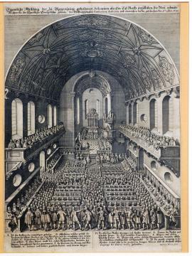
Řezno, On
05.12.1631The engraving represents the interior of the large, vaulted cathedral with a presbytery, altar and pulpit. The cathedral is completely filled with people who are even crowding the oratories and the chancel. Above the picture is the quoted text, and below is the
legend A-N.
Signature: Matheus Merian fecit.
Autor: Unknown
Original name: Eigentliche Abbildung der zu Regensburg gehaltenen Solennien als ein E. E. Rath daselbsten die Neuerbauten Kirchen für den Christliche Evangelische Gemein, der heil. Dreifaltigkeit, consecrieren, und einweihen lassen geschehen den 5. 10bris 1631.
Katalogová čísla: Collection Český Šternberk, kód: 159/318
The print represents the ceremony of the consecration of the evangelical cathedral in Regensburg on the 5th of December 1631, i.e. a time when Regensburg was still firmly in the hands of the Catholic powers and when Gustav Adolf was penetrating south-west to Rhine. It can be assumed the the ceremony of the consecration of a Protestant cathedral in Regensburg could only have gone ahead without disruptive intervention by Catholics as a result of a change in the situation in favour of the Swedes after the Battle of Breitenfeld. However, Regensburg was only conquered by the Swedes under the command of Bernard of Weimar on the 5th of November 1633, and on the 16th of July 1634 it was taken back by Archduke Ferdinand (son of Emperor Ferdinand II.).
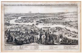
Oppenheim, On
07.12.1631The Rhine flows through the illustrated landscape, and the army of Gustav Adolf King of Sweden is advancing across it. In the foreground there are some small-scale military scenes with cavalry. On the other bank of the Rhine is the town of Oppenheim, already in the grip of sizeable Swedish forces.
Above the picture is the above-quoted German text, and the legend A-V is below. The engraving is the work of Wenceslaus Hollar; it does not actually contain Hollar's signature but Urzidil states in his work on Hollar that it has been safely confirmed that the clash at Oppenheim was drawn by Hollar, who watched the course of the battle with his own eyes.
Signature: Not available
Autor: Unknown
Original name: Abbildung des Ohrts und gelegenheit, da Ihre Majestät der König zu Schweden mit dero Armeen über den Rhein gesetzt, die Spanische Reuterei in die Flucht gebracht und die Statt Oppenheim eingenohmen 7. 10bris 1631.
Katalogová čísla: Collection Český Šternberk, kód: 160/257
After the victorious Battle of Breitenfeld, Gustav Adolf turned westward with his army towards the middle of the Rhine, where he conquered several important cities. On the 6th of December he reached the Rhine, behind which lies the town and castle of Oppenheim. A smaller Swedish division forded the river and attacked the Spanish cavalry on the other bank. The Swedes continued to fight an open battle until the morning of the 7th of December, when it became possible for them to concentrate more troops on the other bank of the Rhine. The Oppenheim fortress “Sternschantze“ surrendered without a fight, and after a brief resistance the town surrendered as well. After that the castle was conquered, where 500 Spanish soldiers were killed with the active support of the population. A monument in the shape of an obelisk was built at the place where Gustav Adolf crossed the Rhine.
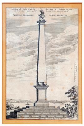
On
20.12.1631 (do 31.12.1631)The print shows a large, four-sided pillar (obelisk), resting on a base of four globes. A Swedish lion is drawn on the pillar. Beside the monument there are two officers – most likely an honour guard. The Rhine flows in the background. The above-quoted text is located on the picture beside the pillar.
Signature: Not available
Autor: Staud Mettias, architekt a rytec
Original name: Abbildung der Säule, so Ihr. M. dem König in Schweden an dem Ort da er über Rhein gesetzt, zur Gedächnuss aufgerichtet worden.
Piramis in memoriam Rheni traiectus. Mat. Staud architekt reg. suae M. designavit.
Katalogová čísla: Collection Český Šternberk, kód: 161/403
The depicted pillar was built in honour of Gustav Adolf on the bank of the Rhine, not far from Mainz, in December 1631. This is the place where the Swedish army crossed the Rhine and and advanced westward to liberate the Lower Palatinate, from which the Spanish had expelled the unhappy Czech “winter king” Frederick of the Palatinate, who then crossed all of Bavaria in the victorious Swedish king's procession and is illustrated on several engravings in our collection.
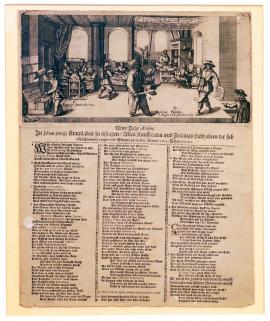
On
01.01.1632 (do 10.01.1632)The picture represents a printing press, a newspaper editorial office and administrative office, and a publication with a large number of people busy with various related tasks. The main functionaries are labelled with the letters A-G, and their literary activities and promotional efforts are described in detail in the following rhyming text.
Signature: Not available
Autor: Unknown
Original name: Newe Jahr Avisen, In Jehan Pelagi Kramladen zu erfragen, Allen Kauffleuten und Zeitungs-liebhabern die sich täglich darmit tragen und schleppen zu diesem Newen 1632 Jahre dedicieret.
Katalogová čísla: Collection Český Šternberk, kód: 163/78
This is a promotional leaflet issued at the time in which there was a power shift during the Thirty Years' War in favour of the Protestants. The turning point between the two periods was the Battle of Breitenfeld on the 17th of September 1631. The poem initially characterizes the publishing and journalistic activities at the time of the rising power of the Imperial League, when general Tilly and his associates went from one victory to another. The description of thiss period is, of course, highly subjective; the Catholics's successes are deliberately exaggerated so that the contrast arising from the defeat at Breitenfeld is even more noticeable. Here we see well-known (from other engravings) arguments and comparisons: Magdeburg – Tilly's bride, a banquet and spoiled Imperial stomachs – the defeat at Breitenfeld, etc.. The poem ends with the assurance that the northern lion (i.e. Gustav Adolf) which appeared on the battlefield will pull out the eagle's (i.e. the Emperor's) feathers and dull its sharp talons, since the word of God and Luther's teaching never pass away.
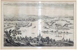
Gustavsburg, On
01.01.1632 (do 28.02.1632)On the picture we can see the territory around the confluence of the Mohan and the Rhine, near Mainz. On the bank of the Mohan there is a fortress in the shape of a star; a little further along the river there are several islands. The pontoon bridge leads to Mainz. In the foreground there is a small village with a church tower and two male figures. On the left there is a stylized tree and another small church. In the sky there is an inscription: “Gustaviburgum“.
Signature: Not available
Autor: Unknown
Original name: Abrisz und Gelegenheit der Neuerbauten Schwedischen Festung Gustavusburg undten am Auslauff des Mayns in den Rhein.
Katalogová čísla: Collection Český Šternberk, kód: 165/258
After the conquest of Mainz by the Swedes, military actions broke out in the Lower Palatinate, so Gustav Adolf decided to establish a fortification system around Mainz and its environs. This fortification plan also included the building of the fortress in a triangular shape, formed by the confluence of the Mohan and the Rhine. The fortress was originally meant to be named “Pfaffentraub“, but this plan was scrapped and instead it was named “Gustavusburg“. A part of Mainz still goes by this name today. The described events took place at the beginning of 1632.
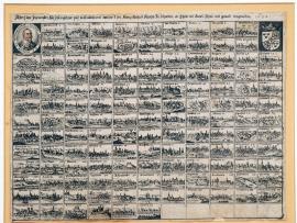
On
01.01.1632 (do 31.12.1632)The tableau is divided is divided into small rectangles in which pictures of various cities, fortresses etc. have been drawn, identified by their names. In the middle, there is a portrait of Gustav Adolf in profile, in an oval, with the inscription “Gustav. Adolph. D. G. Svecor. et Vandalor. Rex.“ On the right-hand side, there is a Swedish royal coat of arms.
Signature: Not available
Autor: Unknown
Original name: Abrisz der fürnemsten Stätt, Festungen, Päsz in Teutschland welche I. M. König Gustav Adolf zu Schweden etc. theils mit Accord, theils mit Gewalt eingenommen 1632.
Katalogová čísla: Collection Český Šternberk, kód: 195/211
The engraving contains 134 small views of various cities, fortresses, strategic points etc. which were conquered by King Gustav Adolf of Sweden and his army during his campaign in Germany between 1630 and 1632. Give the relatively short time period (2 years) and the large numbered of places conquered, it was unquestionably a magnificent battle campaign from a military point of view.
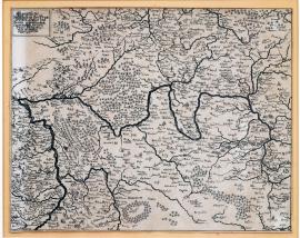
On
01.01.1632 (do 31.12.1632)This is a very detailed map of west German territory, showing the flow of the Mohan and the Rhine. All the towns and villages have been drawn in detail.
Signature: Not available
Autor: Unknown
Original name: Eigentliche Delineation des Fränkischen Kreises und dessen angränzenden Landschaften darinnen jetziger Zeit das Kriegswesen vornemblich seinen Lauff hat. Anno 1632.
Katalogová čísla: Collection Český Šternberk, kód: 196/110
The focal point of hostilities in 1632 was in Silesia and Bavaria (Franconia is a part of Bavaria). The armies of Waldstein and Gustav Adolf operated here. Other German territories, however, were also dragged into the vortex of war, as it was customary – mainly due to supply reasons - to distribute troops over a large territory and take all of the civilian population's supplies and food early on, before the enemy's army has a chance to do so. Besides direct hostilities, the very effective tactic of plundering the enemy's territory was practised, which understandably always considerably weakened the enemy's fighting fitness.
On
01.01.1632 (do 31.12.1632)There is a Latin inscription ‘Trifolium unionis aureum in sanctae huius concordiae vinculum‘ in the painting. There are three Protestant princes portrayed: the Swedish King, the Saxon Electorate and the Brandenburg Electorate clad in military clothing and wearing large hats. They are shaking their right hands, which are symbolically bound by a ribbon. The princes are standing on a clover shamrock and marked by their respective coats of arms. The sun is beaming on them from behind the clouds, above them are various biblical psalms. A mounted cavalry regiment is galloping in the background. Next to the picture are Latin and German psalms and a bit lower down are verses that praise the decision of the three Protestant princes to enter into an Alliance against the Emperor and the powerful Catholic League.
Signature: Not available
Autor: Unknown
Original name: Schwedischer Bundt mit zweyen Churfürsten, Sachsen und Brandenburg. Im Jahr MDXXXII.
Katalogová čísla: Collection Český Šternberk, kód: 197/138
The Alliance of three Protestant princes (the Swedish King, the Saxon Electorate and the Brandenburg Electorate) was established before the defeat of the Imperial army in the Battle of Breitenfeld on 17 September 1631, even though Brandenburg was neutral at that time. A formal agreement confirmed the Alliance one year later. However, the Alliance started loosing its powers soon after the death of the Swedish King Gustav Adolph as John George of Saxon disliked seeing any interfering of foreign powers into the matters of the Holy Roman Empire and was more or less on the fence between the Catholics and the Protestants. The Alliance between the Saxons and the Swedish ended later on.
On
01.01.1632 (do 31.12.1632)The picture depicts the Swedish King Gustav Adolph standing on a carriage with the Protestant princes ousted out by the Catholics. The wagon is pulled by animals symbolising some of the Kings characters, for instance, a lion (i.e. big-heartedness], a fox (i.e. carefulness) etc. A limp female body with her mouth and hand bandaged is lying to the right. The woman is holding a rattle in her bandaged hand and is in a quite a wretched state. She represents the Christianity brought by the Catholics headed by the Pope, which is now doomed. ‘Herr Dona’ (i.e. Achac, the Burgrave of Dohna), a Protestant nobleman and a zealous supporter of the Swedish King, is coming towards the carriage holding a sheet of paper in his hand with the inscription ‘pacem’, i.e. peace. It contains the honest wishes and the purity of thoughts of the nations that trust Gustav Adolph. The woman is giving handing and weapons to the king, i.e. the God’s help, which guides the king's deeds. Another female figure with a cross in her hand is lying to the left and pointing the right direction for the carriage. She represents the ‘religion’. There are many various allegoric scenes in the picture, which praise the King Gustav Adolph and disgrace his opponents. The long German poem below the painting has the same meaning. All allegories are marked with letters A – Z, their meaning is explained in the caption.
Signature: Not available
Autor: Unknown
Original name: Schwedischer Zug das ist: Guter Anfang zu der instehenden Göttlichen Hülfe und Exempel der rechten Busz. Gedruckt im Jahr MDCXXXII.
Katalogová čísla: Collection Český Šternberk, kód: 198/133
The message issued by the Protestants glorifies the arrival of the King Gustav Adolph of Sweden to Germany. It regards the king as the saviour of the Protestant faith from the power of the Emperor and the Pope, which exerted in almost the entire Germany at that time. The victorious Swedish military campaign liberated large parts of Germany from the Pope’s followers, wining a number of bloody battles over the Imperial army. However, this ended upon the death of Gustav Adolph at the Battle of Lützen.
On
01.01.1632 (do 31.12.1632)Wallenstein is seated in an armchair and clad in ceremonial clothing with the Order of the Golden Fleece attached to his breast. Two colonels are standing on each side of Wallenstein. All three of them are smiling. Only this picture is left from the original engraving so the explanation usually placed below it is missing. The top part of the print with the above stated text is also missing. It was put here only to make the understanding of the meaning of the depicted scene easier.
Signature: Not available
Autor: Unknown
Original name: Wahre Historie des Wallensteinischen Gelächters.
Katalogová čísla: Collection Český Šternberk, kód: 199/347
The print is likely to illustrate the joy and satisfaction of Wallenstein himself as well as his army and the majority of inhabitants of the Holy Roman Empire over his reinstallation to the rank of General, the most important post in the Imperial army. This was a natural consequence of several defeats and the critical war situation of the Imperial forces, which developed after Wallenstein was striped of his rank on an impulse of Maximilian I the Elector of Bavaria.
On
01.01.1632 (do 31.12.1632)The painting depicts the Peace (‚pax‘) represented by a female figure sitting in the middle of ruins with her head leaned in her left hand. There is a man with a sword at his side in front of the ruin. He is wearing short clothing and a hat. There is a long German poem under the picture. In the form of a dialogue between the Peace and the described man (the so-called ‚old German man‘) it denounces the war and its consequences.
Signature: Not available
Autor: Unknown
Original name: Desz verjagden Friedens erbärmliche Klagred über alle Städt der Welt. Im Jahr MDCXXXII.
Katalogová čísla: Collection Český Šternberk, kód: 200/130
This is a pacifist leaflet from 1632, which convincingly expresses the opinion of the majority of inhabitants of the Holy Roman Empire, exhausted by the long lasting war. In the rhymed dialogue the ‚Peace‘ is complaining to the ‚Old German Man‘ that it has not found a shelter anywhere. Everywhere it has only seen hatred, vindictiveness and other vices and it has been rejected by the peasantry, the merchants as well as by the nobility. There is a certain millenarianism and desperation in its words. The only solution to all the evil caused by the war is the end of the world. In the end the ‚Old German Man‘ decides to ask the God for the gift of Peace.
On
01.01.1632 (do 31.12.1632)The print depicts an old German man wearing a beautiful robe, who is throwing around leaves of paper covered in writing: ‚der sih dich für‘, which means,the person who can foresee the future events and is warning the public. The Jesuits are picking up the leaflets, while others are burning them. There is a ship on the river taking the propaganda prints around. The Electorate John George of Saxon with an inscribed sheet of paper in his hand is standing at the bottom right in front of his horse. A long German poem is below the picture. All depicted persons (A, B, C, D, E, F, G) have something to say in it. It is stated in Zíbrt and Drugulin’s descriptions of this print that on the far right of the painting are portrayed John George of Saxon and the King Gustav Adolph,holding sheets of papers in their hands with the words ‚der sih dich für‘ on them. This painting shows two figures on the far right, however only one of them, possibly the Electorate of Saxon, is holding a sheet of paper. The second figure shows no royal attributes and it is more likely to be a stableman of John George of Saxon. Apart from that, this copper engraving corresponds with the one described by Drugulin and Zíbrt exactly.
Signature: Not available
Autor: Unknown
Original name: DER SIH DICH FÜR.
Katalogová čísla: Collection Český Šternberk, kód: 201/1
The leaflet shows the success of the Protestant propaganda in the Catholic camp following the victory of the Protestant army (Swedish and Saxon) over the Imperial army in the battle of Breitenfeld in 1631. The politics of the Electorate John George of Saxon’s remained on the fence between the two movements and it was unclear which side he would support in the end. When he finally joined the Swedish just before the battle, dooming thus the Imperial army to the defeat, he earned a great response by the Protestants. Repeatedly they spoke about it, publishing heaps of propaganda prints. Many of those are part of our collection. It is notable that these leaflets often mockingly compare the defeat of the Imperial army at Breitenfeld to a banquet, where the Imperial supporters together with the members of the Catholic League ate too many delicacies and sweets.
On
01.01.1632 (do 31.12.1632)Two chevaliers are facing each other while looking at the Imperial sword, sceptre, orb and a Jesuit biretta placed on a cushion. There is a two-stanza German poem below this scene, which praises the Protestants’ victory at the battle of Breitenfeld and explains the meaning of the picture.
Signature: Not available
Autor: Unknown
Original name: Der Jesuiten Monarchi. Gedruckt im Jahr MDCXXXII.
Katalogová čísla: Collection Český Šternberk, kód: 202/144
The chevaliers are surprised to see the Jesuit biretta lying side by side with the Imperial Regalia. The answer lies in the poem below the picture. Apparently, the Emperor lost his power by handing the state issues fully to the Church (i.e. Jesuits). However, the text is also expressing a hope that the defeat at Breitenfeld will end the unlimited influence of the Jesuits.
Drusenheim, On
25.01.1632On the picture there are two burning field fortifications located on both banks of the Rhine, one at Drusenheim (nearby, there is an island on the Rhine);
another one, lower down, is surrounded by peasants. Beneath the picture there is a three-verse German poem glorifying the liberation of the enemy. The quoted German text is shown above the pictorial part of the print.
Signature: J. v. Heyden fecit.
Autor: Heyden Jacob van der, holandský rytec a nakladatel se sídlem ve Strasburku
Original name: Eigentlicher Abrisz der Situation und Demolierung der zwo Schantzen am Rhein, welche zwischen Hagenau und Lichtenaw von dem Obristen Ossa Anno 1630 gebawet, jetzo aber dem Vatterland und Freyheit zum besten 1632 im Jenner wider abgebrannt und geschleift worden.
Katalogová čísla: Collection Český Šternberk, kód: 164/336
After his victory at Breitenfeld, Gustav Adolf retreated with his army to the west and conquered almost all the Imperial towns and fortresses there; especially those belonging to the Spanish. He occupied the entire territory around the Rhine and then moved on to Bavaria so that he could complete his victory here. The remaining Spanish footholds in the Rhineland were then conquered by Swedish generals, who stayed here after the main army left for Bavaria. In this way, even two small fortresses on either side of the Rhine which had been built by the Spanish colonel Ossa in 1630 fell into the hands of the Swedes; theses were demolished and burned on the 25th of January 1632, to the great delight of the local population.
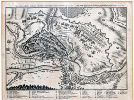
Donauwörth, On
16.03.1632The engraving shows the Danube, into which the Wernitz river flows near the township of Donauwörth, lying in part on the island of Wernitz. On the right-hand side, the Swedish army is attacking. The quoted Latin-German text is above the pictorial part of the print; the legend A-S is at the bottom.
Signature: Not available
Autor: Unknown
Original name: Urbs Donaverda unacum obsidione per Svecos facta mense martio Anno 1632.
Die Statt Thonawerth sambt der schwedischen Belagerung 16. März 1632.
Katalogová čísla: Collection Český Šternberk, kód: 166/328
During his victorious campaign in south-west Germany and after the conclusion of a friendship agreement with the city of Nuremberg, Gustav Adolf and his army began to march towards the Danube and quickly proceeded to Donauwörth. This town was conquered on the 27th of April 1632. In this way a gate into Bavaria was opened for the Swedes, where they would clash with Tilly and Duke Maximillian of Bavaria.
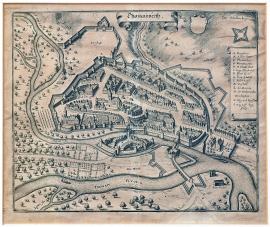
Donauwörth, On
27.03.1632On the engraving we can see the Danube, on which lies the town of Donauwörth which has been drawn very beautifully and in great detail. Behind the town flows the river of Wernitz, which flows into the Danube near Donauwörth. The above-mentioned town name is located on an uncoiled banner in the sky above the illustrated landscape. The decorative banner bears the legend A-O.
Signature: Not available
Autor: Unknown
Original name: Thonauwerth
Katalogová čísla: Collection Český Šternberk, kód: 167/450
This copperplate depicting Donauwörth does not contain any elements connected with military actions, but the print originates from the period of the Thirty Years' War during which Donauwörth twice played an important role. On the 27th of March 1632, it was conquered by Gustav Adolf of Sweden, who advanced victoriously with his army from the Rhine to Nuremberg and intended to enter Bavaria, so that he could complete his victory over Tilly and Duke Maximillian there. The second occasion during the Thirty Years' War that Donauwörth became the centre of attention of the warring powers was in 1648, when the Imperial-Bavarian army under Piccolomini and Enckenfort crossed the Danube at Donauwörth to prevent the Swedes advancing into the Upper Palatinate.
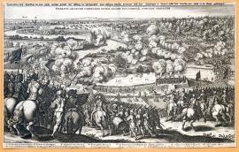
řeka Lech, On
06.04.1632The picture represents the landscape along the river Lech near Rain, approximately 50 km west of Ingolstadt. In the foreground is the Swedish army which is both fording the Lech and crossing it over a bridge which is hazy with smoke. The engraving is of a high artistic value, and its distinctive execution indicates the work of Hollar but unfortunately it has not been signed. On the opposite bank of the Lech, on the right, there is a thick forest. The legend A-I is under the picture, the German text is at the top, and the Latin text is located in the sky in the picture.
Signature: Not available
Autor: Unknown
Original name: Delineation des Treffens an dem Lech, welcher Gestalt der König in Schweden über selbiges Wasser kommen und den Hertzogen in Bayern neben dem Graffen Tilly in die Flucht geschlagen. Praelium ad Licum comissum inter regem Svecorum & comitem Thillyum.
Katalogová čísla: Collection Český Šternberk, kód: 168/236
The Battle of Lech on the 6th of April 1632 was the second decisive clash between the army of Gustav Adolf of Sweden and the Imperial League troops under the command of general Tilly; it was also Tilly's second defeat (he was first beaten by Gustav Adolf at Breitenfeld near Leipzig on the 17th of September 1631). In the time period between these two battles Tilly gathered together his troops which had been scattered at at Breitenfeld, but at the same time he recruited new divisions in the Upper Palatinate. This, however, threatened the Swedes' connection with their northern homeland and forced Gustav to turn against him – into Bavaria. Tilly's army was accompanied by Duke Maximillian of Bavaria (whom we know well from the Battle of White Mountain). A clash occurred at Lech near Rain and both Tilly and Aldringen were seriously wounded at the start of the battle, leaving the Elector of Bavaria at the command point by himself which apparently did not work to their advantage, as he gave the order to retreat from the bank of the Lech that very evening without being forced into it by any Swedish military action. In this way, the gate to the heart of Bavaria was easily opened for the Swedes. This order by Maximillian of Bavaria was, however, the result of a decision by the council of war, so he cannot be held fully responsible for the defeat at Lech. General Tilly, having been mortally wounded, died soon afterwards in Ingolstadt. The Duke of Bavaria thus lost a dedicated, honest and experienced commander; the only property left behind him after his death was his small field luggage, unlike most contemporary commanders – condottieri, who were mainly involved in the military profession so that they could plunder.
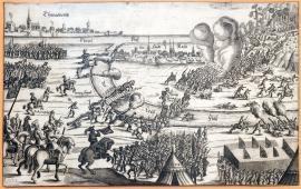
Donauwörth, On
06.04.1632The print depicts the Battle of Lech, in which general Tilly and Elector Maximillian of Bavaria were defeated (killed) by Gustav Adolf of Sweden on the 6th of April 1632. The picture has been drawn in a primitive manner. The Swedish troops are advancing across the Lech by a bridge and a number of fords. On the other bank, beneath the small town of Rain, a cavalry division, firing from rifles and pistols, is attacking the infantry. On the lower edge of the engraving there is a tent with the inscription “1632”. At the top on the left, we can see the Danube and the town of Donauwörth; nearby is a hillock which is being attacked. On the left, in front of a military banner, is Frederick of Palatinate (“Fr. Kö. in Böhem“).
Signature: Not available
Autor: Unknown
Original name: Thonawerth, Donau-Flusz-Die Stadt Rain-der Lech Flusz.
Katalogová čísla: Collection Český Šternberk, kód: 169/316
The Battle of Lech on the 6th of April 1632 was the second decisive clash between the army of Gustav Adolf of Sweden and the Imperial League troops under the command of general Tilly; it was also Tilly's second defeat (he was first beaten by Gustav Adolf at Breitenfeld near Leipzig on the 17th of September 1631). In the time period between these two battles Tilly gathered together his troops which had been scattered at at Breitenfeld, but at the same time he recruited new divisions in the Upper Palatinate. This, however, threatened the Swedes' connection with their northern homeland and forced Gustav to turn against him – into Bavaria. Tilly's army was accompanied by Duke Maximillian of Bavaria (whom we know well from the Battle of White Mountain). A clash occurred at Lech near Rain and both Tilly and Aldringen were seriously wounded at the start of the battle, leaving the Elector of Bavaria at the command point by himself which apparently did not work to their advantage, as he gave the order to retreat from the bank of the Lech that very evening without being forced into it by any Swedish military action. In this way, the gate to the heart of Bavaria was easily opened for the Swedes. This order by Maximillian of Bavaria was, however, the result of a decision by the council of war, so he cannot be held fully responsible for the defeat at Lech. General Tilly, having been mortally wounded, died soon afterwards in Ingolstadt. The Duke of Bavaria thus lost a dedicated, honest and experienced commander; the only property left behind him after his death was his small field luggage, unlike most contemporary commanders – condottieri, who were mainly involved in the military profession so that they could plunder.
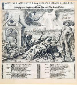
On
11.04.1632On the right-hand side of the picture stands Gustav Adolf wearing a hat with a feather, dressed in armour. In his right hand he is holding a marshal's staff; his stance is overly theatrical. A wailing woman is lying in the middle of the picture (i.e. Augsburg) and on the left is a church with an open gate – the devil is standing at the altar, and above him is the inscription “Wo dieser steht, Gottes Wort vergeht!“ (i.e. “Where he stands, the word of God will cease!”). In front of the cathedral, monks are bringing various books and publications to be destroyed (i.e. the execution of the restitution edict). In the background, we can see the city of Augsburg. In the sky, an angel is floating and pointing at a Hebrew inscription which is illuminated by rays. Beneath the picture is a poem which quotes extracts from the Psalms in the Old Testament and applies their meaning to the subjugated and subsequently liberated city of Augsburg. There is, of course, a religious perspective intended here, as the recovery of the city where the Augsburg Confession was founded was an important event for the Protestant side in contemporary religious life. This copperplate was not signed, but Zíbrt states that the author is W. Endter.
Signature: W. Endter
Autor: Endter W., mědirytec
Original name: Augusta Augustiata, a Deo per Deum leberata. Teutsch: Geängstigt ward Augspurg die Stadt: Gott durch Gott geholfen hat.
Katalogová čísla: Collection Český Šternberk, kód: 170/65
After his victory at Breitenfeld on the 17th of September 1631, Gustav Adolf and his army withdrew to the west of the Rhine, and before he set out on his victorious march into the country of Elector Maximillian of Bavaria, he settled for a short time in front of the city of Augsburg, which was being held by a relatively weak Bavarian garrison. After three days of negotiations, with psychological support in the form of moderate Swedish gunfire, the garrison surrendered and Gustav Adolf triumphantly led his troops into the city. The population, as in most Protestant cities, welcomed them with enthusiasm. Thus, on the 11th of April 1632, the Protestants recovered the city in which the Augsburg Confession had been founded, and which had borne the Imperial restitution edict with great difficulty. All the cathedrals were immediately taken back by the Protestant church, and all the city officials' positions (from burgomaster to night watchman) were occupied by Protestants.
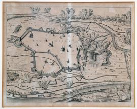
Augsburg, On
11.04.1632The engraving shows a city in which only the main buildings are depicted. In the foreground is the river Lech. Swedish artillery is firing into the city, and several towns in the area are shrouded by smoke and flames. This is a view from above (a so-called bird's eye view). At the top on the right, the flow of the Sinkel river is indicated.
Signature: Not available
Autor: Unknown
Original name: Augspurg
Katalogová čísla: Collection Český Šternberk, kód: 171/274
After his victory at Breitenfeld on the 17th of September 1631, Gustav Adolf and his army withdrew to the west of the Rhine, and before he set out on his victorious march into the country of Elector Maximillian of Bavaria, he settled for a short time in front of the city of Augsburg, which was being held by a relatively weak Bavarian garrison. After three days of negotiations, with psychological support in the form of moderate Swedish gunfire, the garrison surrendered and Gustav Adolf triumphantly led his troops into the city. The population, as in most Protestant cities, welcomed them with enthusiasm. Thus, on the 11th of April 1632, the Protestants recovered the city in which the Augsburg Confession had been founded, and which had borne the Imperial restitution edict with great difficulty. All the cathedrals were immediately taken back by the Protestant church, and all the city officials' positions (from burgomaster to night watchman) were occupied by Protestants.
Augsburg, On
17.04.1632The picture shows the city of Augsburg; the city garrison is leaving by a bridge after the conclusion of an accord – an agreement about the city's capitulation – with Gustav Adolf. In the background there are several villages and small towns, identified by their names. The German text beneath the engraving comments on the conquest of Augsburg by the Swedes in 1632.
Signature: Not available
Autor: Manasser Daniel, rytec a nakladatel v Augsburgu
Original name: Wahrer Bericht, wie und wann ihr köngl. May. in Schweeden unt dero Kriegsarmada für Augspurg getruckt, auch was sich in Kürtze daselbst zugetragen. Getruckt und verlegt durch Daniel Manasser, Burger und Kupferstecher in Augspurg 1632.
Katalogová čísla: Collection Český Šternberk, kód: 172/219
After his victory at Breitenfeld on the 17th of September 1631, Gustav Adolf and his army withdrew to the west of the Rhine, and before he set out on his victorious march into the country of Elector Maximillian of Bavaria, he settled for a short time in front of the city of Augsburg, which was being held by a relatively weak Bavarian garrison. After three days of negotiations, with psychological support in the form of moderate Swedish gunfire, the garrison surrendered and Gustav Adolf triumphantly led his troops into the city. The population, as in most Protestant cities, welcomed them with enthusiasm. Thus, on the 11th of April 1632, the Protestants recovered the city in which the Augsburg Confession had been founded, and which had borne the Imperial restitution edict with great difficulty. All the cathedrals were immediately taken back by the Protestant church, and all the city officials' positions (from burgomaster to night watchman) were occupied by Protestants.
Ingolstadt, On
24.04.1632The etching depicts the city of Ingolstadt (the most important buildings in the city are numbered); beneath the city, along the Danube, Swedish divisions are attacking. On the right, at the head of the division, a Swedish general is riding a horse and holding a marshal's staff (undoubtedly Gustav Adolf). A trumpeter and a cavalry division are watching him. An interesting detail: a cannon is firing from the Ingolstadt field fortification, and hitting a Swedish soldier. The quoted German inscription is above the pictorial part of the copperplate; at the bottom there is a lengthy German text describing in detail the history of the city and ending with a description of the siege of the city by the Swedes on the 24th of April 1632. The legend 1-10 follows.
Signature: Not available
Autor: Unknown
Original name: Kurtzer und eygentlicher Abrisz der Hauptvestung Ingolstatt im Hertzogthumb Bayern, sampt deroselben Gelegenheit, historischer weisz, wie sie zu dieser Zeit gebauet ist, zumtheil ausz eygner erfahrung kürtzlich Beschrieben und ins Kupfer gebracht.
Katalogová čísla: Collection Český Šternberk, kód: 173/207
After his significant victories at Breitenfeld and later at Lech, Gustav Adolf turned to Augsburg and conquered it by agreement. Only then did the Swedes withdraw to Ingolstadt and settle at the south of this city, while at Lech the defeated Imperial-Bavarian army with its mortally wounded commander Tilly, and under the current command of Maximillian of Bavaria, camped north of the city. The Swedish attempts to conquer the city foundered on the heroic resistance by its citizens and by the Bavarian garrison. The Imperial troops withdrew, still on Tilly's advice, and occupied Regensburg while the Swedes seized the capital, Bavaria-Munich. Around this time, general Tilly died in Ingolstadt. The siege of the city ended on the 24th of April 1632.
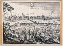
Ingolstadt, On
24.04.1632A view of the city, lying on the far bank of the Danube. Important buildings are identified by their names. A bridge crosses the Danube. In the foreground, on the nearer river bank, the Swedes are attacking the city. Nearby there is a peasant homestead, beside which there are peasants watching the battle. In the sky is the inscription “Ingolstadium“, and higher up there is the city emblem, with a laurel branch around it.
Signature: Not available
Autor: Unknown
Original name: Ingolstadium
Katalogová čísla: Collection Český Šternberk, kód: 174/429
After his significant victories at Breitenfeld and later at Lech, Gustav Adolf turned to Augsburg and conquered it by agreement. Only then did the Swedes withdraw to Ingolstadt and settle at the south of this city, while at Lech the defeated Imperial-Bavarian army with its mortally wounded commander Tilly, and under the current command of Maximillian of Bavaria, camped north of the city. The Swedish attempts to conquer the city foundered on the heroic resistance by its citizens and by the Bavarian garrison. The Imperial troops withdrew, still on Tilly's advice, and occupied Regensburg while the Swedes seized the capital, Bavaria-Munich. Around this time, general Tilly died in Ingolstadt. The siege of the city ended on the 24th of April 1632.
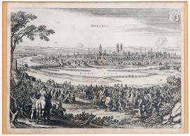
Mnichov, On
10.05.1632The copperplate depicts Munich, which was conquered by King Gustav Adolf of Sweden on the 10th of May 1632 on the basis of an agreement. In the foreground is a scene showing the Munich city council presenting the Swedish king with the keys to the city, and city priviliges. The king is riding through the city on a horse and holding a marshal's staff in his right hand. In his extensive military entourage, the following are identified by their names: the King of Bohemia (i.e. Frederick of the Palatinate), Count Palatine August, Duke Willhelm of Weimar and Duke John of Holstein. On the left, there is a bridge across the river Isar. In the middle of the city is the well-known “Frauenkirche,“ i.e. a church of the Virgin Mary. On the right there is another bridge across the Isar. In the far background, there is a village in flames. In the top left-hand corner, there is the emblem of the city of Munich – “Münchner Kindl“.
Signature: Not available
Autor: Heyden Jacob van der, holandský rytec a nakladatel se sídlem ve Strasburku
Original name: München
Katalogová čísla: Collection Český Šternberk, kód: 175/227
After his victory at Breitenfeld, Gustav Adolf turned west with his army towards the the Rhine, which he crossed near Mainz. During this campaign, which won him the name “King of the Protestants“, he conquered many cities, and drove the Spanish from their bases on several occasions. He conquered almost all of the Lower Palatinate and only then did he return to Bavaria, where in the meantime Tilly's army had recovered and was again becoming a danger to him. The victory at Lech opened the path to Bavaria for him. We besieged Ingolstadt – where his great adversary Tilly had died – without success, but he conquered Augsburg by agreement with the city authorities. In the period before the long encampment by both opposing armies at Nuremberg-Fürth, when Waldstein was again the commander of the Imperial troops (his 2nd generalate), Gustav Adolf besieged Munich and conquered it by agreement with the city council on the 10th of May 1632.
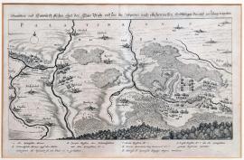
Porýní, On
23.05.1632 (do 26.05.1632)The print depicts a landscape through which several streams flow and across which several villages, identified by their names, are scattered. Below the upper edge of the engraving there is the inscription “Palatinatus“; on the bottom at the right there is a small forest and nearby there is a clash between Spanish and Swedish troops. The above-mentioned text is located above the pictorial part of the print. At the bottom, there is the legend A-G and 1-7.
Signature: Not available
Autor: Unknown
Original name: Grundrisz und Entwurff etlicher Ohrt der Chur-Pfalz und wie die Spanier nach etlichen Treffen endlich gar daraus geschlagen worden.
Katalogová čísla: Collection Český Šternberk, kód: 176/322
When Gustav Adolf was returning from his victorious expedition into the Rhineland with the main part of his army, he left general Gustav Horn there with a sufficient number of troops and ordered him to liquidate the remains of Spanish military bases. Horn took Trier, Speyer and other towns from the Spanish. The Spanish, under the command of the Count of Riedenberg and Don Philip de Sylva, dodged them and chased the Swedes eastward to Württemberg. In several places there were minor clashes and skirmishes between both armies, for example near Ulm. On each occasion, the Spanish were defeated and suffered significant losses, both in terms of men and in the form of the losses of most of their supplies and supply divisions. This was in the period between the 23rd and the 26th of May 1632. Horn did not take part in the expedition; in his place Count Palatine Kristian of Birkenfeld and Count of Rhineland Otto Ludwig commanded the Swedes.
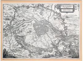
Maastricht, On
09.06.1632 (do 12.08.1632)In the middle of the copperplate is the city of Maastricht, lying above the Moselle. It is surrounded by a thick ring of various fortified buildings. Throughout the entire picture there are numerous military scenes, camps, marching divisions, small skirmishes etc. Individual details are accompanied by explanatory notes. In the bottom right-hand corner, in the foreground, there is a commanding general with his entourage and two trumpeters. The above-quoted inscription is at the top on the right, and nearby two coats of arms have been drawn: a Flemish lion and a six-pointed star; under this there is a measuring scale.
Signature: Not available
Autor: Unknown
Original name: Obsidio Mosae-Traiecti. Belagerung Mastrich. Angefangen den 9. Juny, übergeben den 12. August 1632.
Katalogová čísla: Collection Český Šternberk, kód: 179/427
In August 1632, i.e. at the time when the main opposing armies - the Imperial-Bavarian army under Waldstein and the Swedish army under Gustav Adolf - stood against each other near Nuremberg, general Count Pappenheim was ordered to go to northern Germany with a small Imperial division and hold certain Protestant princes in check. At that time, Frederick Henry of Orange was besieging the city of Maastricht in the Netherlands, which was being held by a Spanish garrison subjugated to the Dutch governess, Archduchess Isabella. When the archduchess realized that Maastricht would not be able to resist for long, she urgently asked Pappenheim for help. He left a part of his army under the command of general Gronsfeld in Westphalia, while he himself hurried with the larger part of his army to help the oppressed city of Maastricht. On the 9th of August 1632 he carried out an attack against the Dutch which failed, mainly due to the fact that the Spanish defenders did not flee the city at the same time. Pappenheim himself was seriously wounded in his stomach, and lost approximately 1,500 to 2,000 men and officers in the battle. He then pulled back, joined Gronsfeld's division once again, and Maastricht capitulated on the 12th of August 1632.
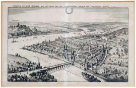
Koblenz, On
20.06.1632The picture shows the city of Koblenz, lying at the confluence of the Moselle and the Rhine. In the foreground there is a bridge across the Moselle; army divisions and firing cannons are arranged around the city. On the left, above the Rhine, is the castle of Herrmanstein. This is a very detailed drawing, particularly reminiscent of Hollar's engravings due to its concept of perspective.
Signature: Not available
Autor: Unknown
Original name: Abbildung der Statt Coblentz und wie selbige von den Schwedischen belagert und eingenohmen worden. 1632.
Katalogová čísla: Collection Český Šternberk, kód: 177/234
The conquest of Rhineland, which followed the Battle of Breitenfeld, was essentially completed by the Swedes and, after his victory over Lech, Gustav Adolf stood with his troops deep in Bavaria. In the Rhineland, there were still a few minor towns left which were being held by the Spanish. The Swedes came, and after a brief siege conquered the towns by agreement. Soon, however, the Swedish garrison which had occupied the conquered city was replaced by a French garrison, as the French were allies of the Swedes at that time. The city of Koblenz was conquered by the Swedes on the 20th of June 1632.
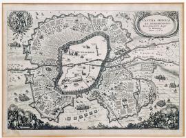
Norimberk, On
01.08.1632 (do 31.08.1632)In the middle of the engraving is the city of Nuremberg, in which only the important buildings and fortifications have been illustrated in detail and are identified by their names. Around the city there is an extensive, fortified Swedish army camp. In both bottom corners, there are unusually beautifully engraved skirmishes between horsemen. At the top on the right there is a decorative baroque vignette, which contains the above-quoted text. On the opposite side, at the same height, there is the emblem of the city of Nuremberg with a laurel branch around it.
Signature: Not available
Autor: Unknown
Original name: CastraSuecica ad Norimbergam. Königl. schwedische Läger zu Nürnberg Anno 1632.
Katalogová čísla: Collection Český Šternberk, kód: 187/245
After his victories at Breitenfeld and Lech, King Gustav Adolf of Sweden and his army entered Bavaria so that they could complete their victory over Elector Maximillian of Bavaria. His troops went on a huge rampage and plundered the country, so the helpless Duke of Bavaria urgently asked the Emperor for help. In March 1632, Waldstein was again summoned by the Emperor; he immediately established a new army and led it to Silesia, where he planned to defeat the troops of John George I. Elector of Saxony. However, there were no major combat clashes but there were lengthy negotiations, especially with the Saxon general Arnim whom Waldstein wanted – outside formal negotiations – to join his army. Since these were secret negotiations with the enemy, this was the start of Waldstein's treacherous activities. Maximillian of Bavaria constantly urged the Emperor to send Waldstein and his army to Bavaria to liberate this country from unbearable Swedish oppression. Waldstein, however, was reluctant to intervene in favour of the Elector of Bavaria, whom he considered his greatest enemy; he was the one who had pushed through Waldstein's dismissal from Imperial services at the electoral assembly in Regensburg in 1630. The Duke of Friedland, however, eventually had to obey the Emperor's order; he advanced across Bohemia into Bavaria and settled in a fixed camp at Fürt near Nuremberg, in the immediate vicinity of the Swedish camp. The large concentration of troops (approximately 50 – 60,000 men) in a small area understandably soon caused unbearable supply problems to both sides. This is why, on the 24th of August 1632, Gustav Adolf decided to attack Waldstein's positions. Long and bloody battles followed, which did not end in a decisive victory. The Imperial forces repelled all the attacks, and they were not expelled from their camps. Gustav Adolf withdrew his troops to Nuremberg. Various negotiations followed, as well as strategic exercises by both armies which eventually led to the Battle of Lützen where King Gustav Adolf of Sweden was killed.
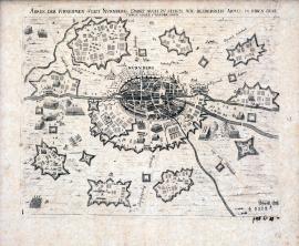
Norimberk, On
01.08.1632 (do 31.08.1632)The engraving, which has been very sharply engraved, illustrates Nuremberg and both of the opposing armies's fortified camps. The Regnitz river flows horizontally. The above-quoted inscription is located above the picture.
Signature: Not available
Autor: Unknown
Original name: Abrisz der fürnehmen Statt Nürnberg, Dabei auch zu sehen wie beiderseits Armee in ihren Quartieren gegen einander liegen.
Katalogová čísla: Collection Český Šternberk, kód: 187a/485d
After his victories at Breitenfeld and Lech, King Gustav Adolf of Sweden and his army entered Bavaria so that they could complete their victory over Elector Maximillian of Bavaria. His troops went on a huge rampage and plundered the country, so the helpless Duke of Bavaria urgently asked the Emperor for help. In March 1632, Waldstein was again summoned by the Emperor; he immediately established a new army and led it to Silesia, where he planned to defeat the troops of John George I. Elector of Saxony. However, there were no major combat clashes but there were lengthy negotiations, especially with the Saxon general Arnim whom Waldstein wanted – outside formal negotiations – to join his army. Since these were secret negotiations with the enemy, this was the start of Waldstein's treacherous activities. Maximillian of Bavaria constantly urged the Emperor to send Waldstein and his army to Bavaria to liberate this country from unbearable Swedish oppression. Waldstein, however, was reluctant to intervene in favour of the Elector of Bavaria, whom he considered his greatest enemy, he was the one who had pushed through Waldstein's dismissal from Imperial services at the electoral assembly in Regensburg in 1630. The Duke of Friedland, however, eventually had to obey the Emperor's order; he advanced across Bohemia into Bavaria and settled in a fixed camp at Fürt near Nuremberg, in the immediate vicinity of the Swedish camp. The large concentration of troops (approximately 50 – 60,000 men) in a small area understandably soon caused unbearable supply problems to both sides. This is why, on the 24th of August 1632, Gustav Adolf decided to attack Waldstein's positions. Long and bloody battles followed, which did not end in a decisive victory. The Imperial forces repelled all the attacks, and they were not expelled from their camps. Gustav Adolf withdrew his troops to Nuremberg. Various negotiations followed, as well as strategic exercises by both armies which eventually led to the Battle of Lützen where King Gustav Adolf of Sweden was killed.
Maastricht, On
09.08.1632A small engraving, engraved á la Merian or Hollar (Hollar worked for a number of years in Merian's workshop in Frankfurt; this is why there is an obvious similarity between the artistic concepts of both engravers). In the left foreground, a riding scene is depicted. In the middle, there is the wide flow of the river Meuse, and over it a bridge. The city of Maastricht lies in the background, and there is a battle in progress close to it. The print comes from the work “Theatrum Europaneum“.
Signature: Not available
Autor: Unknown
Original name: Grafen von Pappenheims Anfall auff das Städtische Läger vor Mastrich, 1632.
Katalogová čísla: Collection Český Šternberk, kód: 178/304
In August 1632, i.e. at the time when the main opposing armies - the Imperial-Bavarian army under Waldstein and the Swedish army under Gustav Adolf - stood against each other near Nuremberg, general Count Pappenheim was ordered to go to northern Germany with a small Imperial division and hold certain Protestant princes in check. At that time, Frederick Henry of Orange was besieging the city of Maastricht in the Netherlands, which was being held by a Spanish garrison subjugated to the Dutch governess, Archduchess Isabella. When the archduchess realized that Maastricht would not be able to resist for long, she urgently asked Pappenheim for help. He left a part of his army under the command of general Gronsfeld in Westphalia, while he himself hurried with the larger part of his army to help the oppressed city of Maastricht. On the 9th of August 1632 he carried out an attack against the Dutch which failed, mainly due to the fact that the Spanish defenders did not flee the city at the same time. Pappenheim himself was seriously wounded in his stomach, and lost approximately 1,500 to 2,000 men and officers in the battle. He then pulled back, joined Gronsfeld's division once again, and Maastricht capitulated on the 12th of August 1632.
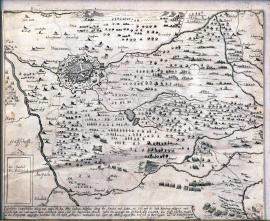
Norimberk, On
09.08.1632This is a depiction of the situation in the Swedish and Imperial camps at Nuremberg. At that time, on the 9th of August 1632, the Swedes attacked Waldstein's supply expedition in Freudenstadt. At the top on the left is Nuremberg, the river Regnitz flows through diagonally, and in the place where the river touches the edge of the print there is the township of Fürt, where Imperial forces camped. At the bottom on the right, the affair in Freudenstadt, which is mentioned in the heading, is illustrated. The afore-mentioned inscription is below the picture. Throughout the entire engraving, many small scenes – mainly military ones - have been drawn. In the bottom left-hand corner there is a square with the inscriptions “Sw. Swedisch“ and “Fr. Friedländisch“.
Signature: Not available
Autor: Unknown
Original name: Eigentlicher conterfehtlicher Abrisz wasz maszen Ihr. kon. May. Gustavus Adolphus, könig der Sweden, Goten, etc. sich um die Statt Nürnberg gelägert, auch dieselbe Statt und umbringent Läger befestigen lassen, und der kayserlichen Armada unter dem Hertzoge von Fridland alda erwartett den 30. Juli / 9. August deszelben Magasin in der Freyenstatt, angegriffen, verbränd, und den Entsatz geschlagen, nachmahlen dasz Läger am Altenberg angegriffen, und sich zur Furt logiert, wo die Fridländische vorhin gelegen.
Katalogová čísla: Collection Český Šternberk, kód: 180/41 D
In the second half of 1632, when the Imperial and Swedish armies camped opposite one another at Nuremberg, there was a serious food shortage and both armies were forced to undertake expeditions in order to obtain supplies. On the 9th of August 1632 the Imperial forces, accompanied by a military division, undertook an expedition to Freudenstadt to obtain food. However, they were unexpectedly attacked there by the Swedes, who took away their haul and burned the town of Freudenstadt down. General Tupadl was in command of the Swedish division.
Norinberk, On
09.08.1632The print shows the town of Freudenstadt, lying on a hillock in flames. The surrounding landscape is mountainous. The town is apparently being attacked by Swedish horsemen. In the foreground there is a general, most likely Gustav Adolf, with a cavalry division; on the other side (on the left) there are several horsemen with banners and bugles. The quoted text is above the picture, and at the bottom there is another, extensive German text describing the course of the illustrated event.
Signature: Not available
Autor: Manasser Johann Jerg, rytec v Augsburgu
Original name: Kurtze Beschreibung der Freystatt im Hertzogthumb Francken gelagen, wie dieselbe von ihrer Königl. Mayestät erobert und eingenommen. Getruckt zu Augspurg bey Johann Jerg Manasser Kupfferstecher, wohnhafft auffm Creutz.
Katalogová čísla: Collection Český Šternberk, kód: 181/215
At the time when the Imperial and Swedish armies camped opposite one another at Fürt near Nuremberg, the troops suffered from food shortages so both sides undertook expeditions to obtain supplies. Understandably, both sides tried to disrupt such actions on the part of their opponent, and maybe even take their haul. On the 9th of August 1632, a Swedish division under colonel Tupadl arrived at the town of Freudenstadt where the Imperial forces had a large storehouse of food; the Swedes looted the storehouse, set the town on fire and killed the Imperial garrison. The Imperial forces immediately dispatched a larger division to rescue supplies for Freudenstadt, but Gustav Adolf was also soon informed; he stood at the head of several cavalry regiments, and rushed with them to Freudenstadt. There was a clash, which the Swedes won. From the Imperial forces, colonel Sparr and commissarial colonel Blaurer were killed. On the Swedish side, colonel Riesz and two chamber ensigns were killed.
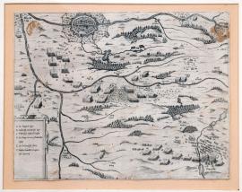
Norinberk, On
09.08.1632The engraving has been made in the form of a map of the territory between Nuremberg and Freudenstadt, through which the rivers Pegnitz and Regnitz flow. Both cities are illustrated. The clash between the Swedes and the Imperial forces is in the middle of the engraving. The etching is unusually finely made. Under the picture, there is the legend A-F.
Signature: Not available
Autor: Unknown
Original name: Nürnberg-Freienstadt
Katalogová čísla: Collection Český Šternberk, kód: 182/283
In the second half of 1632, when the Imperial and Swedish armies camped opposite one another at Nuremberg, there was a serious food shortage and both armies were forced to undertake expeditions in order to obtain supplies. On the 9th of August 1632 the Imperial forces, accompanied by a military division, undertook an expedition to Freudenstadt to obtain food. However, they were unexpectedly attacked there by the Swedes, who took away their haul and burned down the town of Freudenstadt. General Tupadl was in command of the Swedish division. At the time when the Imperial and Swedish armies camped opposite one another at Fürt near Nuremberg, the troops suffered from food shortages so both sides undertook expeditions to obtain supplies. Understandably, both sides tried to disrupt such actions on the part of their opponent, and maybe even take their haul. On the 9th of August 1632, a Swedish division under colonel Tupadl arrived at the town of Freudenstadt where the Imperial forces had a large storehouse of food; the Swedes looted the storehouse, set the town on fire and killed the Imperial garrison. The Imperial forces immediately dispatched a larger division to rescue supplies for Freudenstadt, but Gustav Adolf was also soon informed; he stood at the head of several cavalry regiments, and rushed with them to Freudenstadt. There was a clash, which the Swedes won. From the Imperial forces, colonel Sparr and commissarial colonel Blaurer were killed. On the Swedish side, colonel Riesz and two chamber ensigns were killed.
Wiesloch, On
16.08.1632The picture shows the Battle of Wiesloch, which lies approximately 20km south of Heidelberg. In the foreground on the left there is a military scene, drawn á la Hollar. In a nearby valley, troops are fighting; a short distance away is the town of Wiesloch. In the background, there is a forested mountain range. The quoted German text is beneath the picture, and at the bottom there is the legend A-G.
Signature: Not available
Autor: Unknown
Original name: Delineation des Treffens, so zwischen den Schwedischen und Kayserlichen bey Wiseloch vorgangen.
Katalogová čísla: Collection Český Šternberk, kód: 183/310
The Imperial commander of the city of Heidelberg, colonel Metternich, occupied the township of Wiesloch, lying approximately 20 km south of Heidelberg, in August 1632. When he failed to conquer Wiesloch due to a lack of troops, Metternich sent a courier (a certain corporal) to general Osso, Montecucculi (incorrectly spelled in the original – editor's note) and Margrave Willhelm with a request for help against Wiesloch. However, the Imperial corporal was arrested by Swedes on the way and interrogated. When he revealed his message, the Swedish general Gustav Horn set off for Wiesloch with his troops and suddenly attacked the Imperial cavalry which was just coming to Metternich's aid. The Swedes won; out of approximately Imperial cuirassiers 200 were killed at Wiesloch, as well as commanding colonel Montballion and several other officers. This clash took place on the 16th of August 1632.
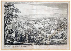
Wiesloch, On
16.08.1632The engraving shows a forested landscape where the Battle of Wiesloch took place. On the left of the picture, there is a village with a pointed church tower. In the foreground, on the left, there are several horsemen and musketeers. The execution of this engraving bears witness to its origin in Merian's workshop in Frankfurt. Under the picture, there is the legend A-G.
Signature: Not available
Autor: Unknown
Original name: Het Treffen tussen de Swesche en Kaysersche by Wiseloch.“
Katalogová čísla: Collection Český Šternberk, kód: 184/447
The Imperial commander of the city of Heidelberg, colonel Metternich, occupied the township of Wiesloch, lying approximately 20 km south of Heidelberg, in August 1632. When he failed to conquer Wiesloch due to a lack of troops, Metternich sent a courier (a certain corporal) to general Osso, Montecucculi (incorrectly spelled in the original – editor's note) and Margrave Willhelm with a request for help against Wiesloch. However, the Imperial corporal was arrested by Swedes on the way and interrogated. When he revealed his message, the Swedish general Gustav Horn set off for Wiesloch with his troops and suddenly attacked the Imperial cavalry which was just coming to Metternich's aid. The Swedes won; out of approximately Imperial cuirassiers 200 were killed at Wiesloch, as well as commanding colonel Montballion and several other officers. This clash took place on the 16th of August 1632.
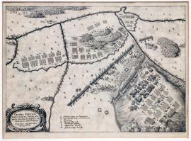
Fürth, On
24.08.1632On the right side of the picture there is the hillock “Altenberg“ and the Imperial camp; on the opposite side (diagonally across the sheet) is the Swedish position. The flows of the Regnitz and Pegnitz rivers are very distinctly drawn. At the bottom on the left, there is a decorative cartouche which contains the above-mentioned inscription, and the legend A-G is at the bottom.
Signature: Not available
Autor: Unknown
Original name: Castra Svecica Furti posita. Fridlandium ducem in monte veteri dicto opugnatia. Kay. Läger aff dem Alten. Berg bey Fürdt.
Katalogová čísla: Collection Český Šternberk, kód: 185/38d
After his victories at Breitenfeld and Lech, King Gustav Adolf of Sweden and his army entered Bavaria so that they could complete their victory over Elector Maximillian of Bavaria. His troops went on a huge rampage and plundered the country, so the helpless Duke of Bavaria urgently asked the Emperor for help. In March 1632, Waldstein was again summoned by the Emperor; he immediately established a new army and led it to Silesia, where he planned to defeat the troops of John George I. Elector of Saxony. However, there were no major combat clashes but there were lengthy negotiations, especially with the Saxon general Arnim whom Waldstein wanted – outside formal negotiations – to join his army. Since these were secret negotiations with the enemy, this was the start of Waldstein's treacherous activities. Maximillian of Bavaria constantly urged the Emperor to send Waldstein and his army to Bavaria to liberate this country from unbearable Swedish oppression. Waldstein, however, was reluctant to intervene in favour of the Elector of Bavaria, whom he considered his greatest enemy; he was the one who had pushed through Waldstein's dismissal from Imperial services at the electoral assembly in Regensburg in 1630. The Duke of Friedland, however, eventually had to obey the Emperor's order; he advanced across Bohemia into Bavaria and settled in a fixed camp at Fürt near Nuremberg, in the immediate vicinity of the Swedish camp. The large concentration of troops (approximately 50 – 60,000 men) in a small area understandably soon caused unbearable supply problems to both sides. This is why, on the 24th of August 1632, Gustav Adolf decided to attack Waldstein's positions. Long and bloody battles followed, which did not end in a decisive victory. The Imperial forces repelled all the attacks, and they were not expelled from their camps. Gustav Adolf withdrew his troops to Nuremberg. Various negotiations followed, as well as strategic exercises by both armies which eventually led to the Battle of Lützen where King Gustav Adolf of Sweden was killed.
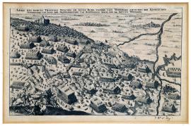
Norinberk, On
24.08.1632On the left side of the picture is the hillock “Altenberg“ on which battles between numerous army divisions broke out near the Imperial fortifications. On an elevated area in the forest, there is a castle or convent. At the bottom on the left there are two horsemen, shooting at each other. A little further away, the Regnitz river flows; at its confluence with another river there is a small village with a church.
Signature: Not available
Autor: Unknown
Original name: Abris des harten Treffens, welches am Alten Berg unfern von Nürnberg zwischen den königlichen schwedischen und dann der Friedländischen und Bajerischen Armeen den 24. Augusti vorgangen.
Katalogová čísla: Collection Český Šternberk, kód: 186/82
After his victories at Breitenfeld and Lech, King Gustav Adolf of Sweden and his army entered Bavaria so that they could complete their victory over Elector Maximillian of Bavaria. His troops went on a huge rampage and plundered the country, so the helpless Duke of Bavaria urgently asked the Emperor for help. In March 1632, Waldstein was again summoned by the Emperor; he immediately established a new army and led it to Silesia, where he planned to defeat the troops of John George I. Elector of Saxony. However, there were no major combat clashes but there were lengthy negotiations, especially with the Saxon general Arnim whom Waldstein wanted – outside formal negotiations – to join his army. Since these were secret negotiations with the enemy, this was the start of Waldstein's treacherous activities. Maximillian of Bavaria constantly urged the Emperor to send Waldstein and his army to Bavaria to liberate this country from unbearable Swedish oppression. Waldstein, however, was reluctant to intervene in favour of the Elector of Bavaria, whom he considered his greatest enemy; he was the one who had pushed through Waldstein's dismissal from Imperial services at the electoral assembly in Regensburg in 1630. The Duke of Friedland, however, eventually had to obey the Emperor's order; he advanced across Bohemia into Bavaria and settled in a fixed camp at Fürt near Nuremberg, in the immediate vicinity of the Swedish camp. The large concentration of troops (approximately 50 – 60,000 men) in a small area understandably soon caused unbearable supply problems to both sides. This is why, on the 24th of August 1632, Gustav Adolf decided to attack Waldstein's positions. Long and bloody battles followed, which did not end in a decisive victory. The Imperial forces repelled all the attacks, and they were not expelled from their camps. Gustav Adolf withdrew his troops to Nuremberg. Various negotiations followed, as well as strategic exercises by both armies which eventually led to the Battle of Lützen where King Gustav Adolf of Sweden was killed.
Benfeld, On
20.09.1632 (do 19.10.1632)The engraving has been made in the form of a map. In the middle, there is the town of Benfeld, lying approximately 30 km south of Strasbourg above the river Ill. Beneath the town, the river divides into several branches. Around the town, the attackers' field fortifications are illustrated. At the top on the right, there is a rectangular image of the town of Benfeld, the above-mentioned text and the legend A-F. On the right, beneath the picture, there is a detail of the fortifications.
Signature: Not available
Autor: Unknown
Original name: Belägerung der Vestung Benfeld in Nahmen I. K. M. zu Schweden etc. durch I. Excel. Herrn Feldmarschalk Gustav Horn den 20. September 1632.
Katalogová čísla: Collection Český Šternberk, kód: 188/311
After the defeat of Imperial troops at Wiesloch on the 16th of August 1632, the Imperial forces withdrew to Alsace, pursued by the Swedish general Gustav Horn. Along the way he seized several fortified Imperial towns, and on the 20th of September he also besieged Benfeld. The town had fortified, durable and defensive structures, and for a long time resisted the Swedes. At the beginning of October, Imperial forces attempted to come to Benfeld's aid but this plan failed. By the 19th of October 1632, the defenders had used up all their strength and handed over the town to the Swedes on the basis of an agreement, the conditions of which were relatively bearable.
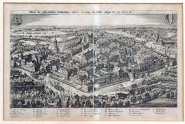
Lipsko, On
22.10.1632This is a view of the city of Leipzig from above (a so-called bird's eye view). The city has been drawn very accurately and in great detail. Around the city there are various battles scenes, and enemy fire. At the top, on the right and left, there are 2 coats of arms. At the bottom, there is the legend A-Z.
Signature: Not available
Autor: Unknown
Original name: Abrisz der Churfürstlichen Sächsischen Statt Leipzig, wie dieselbe jetztiger Zeit im Wesen ist.
Katalogová čísla: Collection Český Šternberk, kód: 189/230
In the time period between the events at Nuremberg-Fürt (August 1632) and the Battle of Lützen (the 6th of November 1632), the focal point of the battles moved from Bavaria to Saxony. On the 22nd of October 1632, the Imperial forces conquered Leipzig by agreement. On the basis of this agreement, the city had to pay Waldstein 50,000 Tolars, and received a small Imperial garrison.
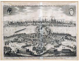
Kolín nad Rýnem, On
01.11.1632 (do 31.12.1632)The suburb of Deutz in Cologne on the Rhine, with an explosion in a church and an attack by Swedish troops, forms the foreground of the engraving. Above this we can see the river Rhine with several mills, and the city of Cologne on the Rhine in the background. In the sky, on the left, there is an Imperial coat of arms containing an eagle, and on the right there is the emblem of the city of Cologne. The German text is above the picture; the legend A-W is at the bottom.
Signature: Not available
Autor: Unknown
Original name: Abbildung der Statt Cöln und gegenüber gelegenen Freyheit Duytz sampt des General Baudissin darauf geschechenen Anfals 1632.
Katalogová čísla: Collection Český Šternberk, kód: 193/451
After Gustav Adolf King of Sweden's victory over Catholic forces in western Germany, the city of Cologne on the Rhine remained neutral by agreement. Irrespective of this fact, however, and for reasons which are unclear, the citizens of Cologne began to build several fortifications near the suburb of Deutz. As soon as general Baudissin found out about these activities at the end of 1632, he carried out an attack on the suburb of Deutz and ordered the newly-built fortifications to be razed to the ground. During this action, many Cologne soldiers were killed or arrested. During the battle in the city, one of the Swedish soldiers hid in a church and set fire to a large amount of gunpowder which was stored there. There was an explosion which destroyed the church and killed approximately 300 citizens of Deutz. This explosion is clearly visible on the copperplate.
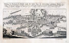
Deutz, On
01.11.1632 (do 31.12.1632)Below the upper edge of the print flows the river Rhine. Immediately under it is the suburb of Deutz with an explosion (the church tower is tumbling down). In the foreground, in front of the city, there are several army divisions and a commanding general holding a marshal's staff, accompanied by several standard-bearers. The quoted German text is above the picture; the legend A-W is at the bottom.
Signature: Not available
Autor: Unknown
Original name: Abbildung der Fortification zu Deutsch sambt des daselbs durch die Schwedischen geschehenen Eingalls 1632.
Katalogová čísla: Collection Český Šternberk, kód: 194/45d
After Gustav Adolf King of Sweden's victory over Catholic forces in western Germany, the city of Cologne on the Rhine remained neutral by agreement. Irrespective of this fact, however, and for reasons which are unclear, the citizens of Cologne began to build several fortifications near the suburb of Deutz. As soon as general Baudissin found out about these activities at the end of 1632, he carried out an attack on the suburb of Deutz and ordered the newly-built fortifications to be razed to the ground. During this action, many Cologne soldiers were killed or arrested. During the battle in the city, one of the Swedish soldiers hid in a church and set fire to a large amount of gunpowder which was stored there. There was an explosion which destroyed the church and killed approximately 300 citizens of Deutz. This explosion is clearly visible on the copperplate.
Lützen, On
06.11.1632The picture, with its relatively large figures, represents a close-up of a battle between several horsemen. The wounded are lying on the ground. On the left, a horseman is firing a gun into Gustav Adolf's back. The turmoil of a battle, partly shrouded in smoke, is in the background.
Signature: Not available
Autor: Unknown
Original name: Todt des Königs von Schweden bey Lüzen 1632.
Katalogová čísla: Collection Český Šternberk, kód: 190/315
According to various sources, the circumstances surrounding the death of King Gustav Adolf at Lützen can be summarized as follows: the King of Sweden ordered the cavalry of the right wing of his army to disperse the opposing Imperial Croats. However, when he noticed that the centre of his position was starting to become weak, he immediately stood at the head of the Finnish regiment and rushed to help the endangered section. He cantered quite a distance ahead of the Finnish division, accompanied by Duke Francis of Saxony-Lauenburg, one page and a stable master. While he was riding he was shot in the shoulder, and shortly afterwards also in the back. The second shot was apparently fired by the Imperial colonel Falkenberg. The king fell from his horse; the Duke of Saxony-Lauenburg and the stable master saved themselves by fleeing, but the page whose name was Leubling stayed with the king and tried to help him to get back into his saddle. However, due to heavy fog (which had also delayed the start of the battle), they could not get their bearings. At that moment an Imperial cavalry division came dashing, but the horsemen did not recognize the wounded king – instead, they thought that he was a high-ranking Swedish officer. They killed the king by stabbing him and shooting him several times, and then they undressed him. His loyal page, who had suffered several wounds, died soon afterwards in Nuremberg. During the course of the battle several cavalry divisions also rode over the king's corpse. When the corpse was found, it had been mutilated to such an extent that the Swedes could not recognize their beloved king and commander. After the battle, the king's body was transported to Weissenfels.
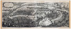
Lützen, On
06.11.1632This broad picture shows the town of Lützen in flames at the top on the right. On the left side, there is an oval cartouche with the quoted Latin text. The middle of the whole picture is filled with the commotion of battle. In the foreground there is a gallows, and nearby a large explosion has been illustrated – most likely an ammunition store.
Signature: M. Merian fecit
Autor: Merian Mateus, mědirytec a nakladatel ve Frankfurtu nad Mohanem
Original name: Typus cruentissimi illius proelii in quo exercitus regis sveciae cum acie caesarea sub duce Fridlandiae cum magna utriusque strage et plerorumque ducum interituu ad Lüzam conflixit ci die VI. Novembris Anno MDCXXXII.
Katalogová čísla: Collection Český Šternberk, kód: 191/212
After local operations at Nuremberg-Fürt in the summer months of 1632, which did not result in a decisive victory, both of the armies – which had camped here in each other's immediate vicinity – departed. King Gustav Adolf stayed in Bavaria with a part of his army so that he could establish a strategic position there against Montecuccoli's troops, who were a danger to him. Waldstein advanced northward, apparently intending to attack Bernard of Weimar who had been set there by the Swedish king. This exercise brought the Imperial army closer to Saxony, and John George Elector of Saxony immediately requested help from both Gustav Adolf and Bernard of Weimar. The Swedes came without delay and both mighty armies, Swedish and Imperial, came into direct contact at Lützen near Leipzig. On the 6th / 16th of November 1632, in the late morning (due to thick autumn morning fog) a great and bloody battle took place. The Swedes initially achieved successes over the Imperial infantry, but Waldstein balanced the situation with a large cavalry attack. Later the Swedes again gained the upper hand, and the situation was becoming dangerous for the Imperial forces. In the late afternoon, the Imperial general Pappenheim – whom Waldstein had called on in a great hurry - arrived with his experienced cavalry. Pappenheim and his regiment immediately executed a fierce counter—attack that forced the victorious Swedes back; this balanced the opponents' positions again. Pappenheim himself was killed in the battle; Waldstein's written order, which Pappenheim had with him during the battle and which was now covered in blood, is exhibited in the Museum of Military History in Vienna. Night came, and ended the bloodshed. The result of the battle can be described as indecisive. Gustav Adolf, who had thrown himself into the worst pandemonium, was killed by two gunshots. Some of the more important Swedish officers killed included: Count Brahe, general Uslar, Ernest of Anhalt, colonel Gerstorf and several officers from the ranks of Czech emigrants. The number of men killed on the Swedish side is estimated to be 4,000 to 5,000. On the Imperial side, apart from Pappenheim (who before his death allegedly sent word to Waldstein that he is happy to die in the knowledge that the Catholic faith's most obstinate enemy, Gustav Adolf, is no longer alive), a number of the highest-ranking officers died. The wounded included Piccolomini, Holk, Breuer, Trčka, Harrach and many others. The number of men killed was roughly the same as that of the Swedes. During the entire course of the battle Waldstein was troubled by pains which forced him down; which is why he had to dismount his horse and allow himself to be carried on a stretcher. After the Battle of Lützen the Imperial forces withdrew to Bohemia, but the Swedish army remained in Saxony.
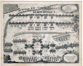
Lützen, On
06.11.1632On the upper side of the print Swedish battle positions are illustrated, in which it is typical that the ranks of the musketeers are distributed between the cavalry squadrons, and that some of the light artillery firing positions are in the vicinity of battle formations, whether they be infantry or cavalry. The position of the Imperial army is illustrated in the lower half of the graphic artwork. A trench occupied by Imperial gunmen, which played an important role during the battle, runs through the middle. On the right, there is a cartouche with the both armies' battle slogans: “Jesus Maria“ (i.e. the Imperial forces' slogan) and “Gott mit uns“ (i.e. the Swedes' slogan). On the right, in the middle of the sheet, is the burning town of Lützen.
Signature: Not available
Autor: Unknown
Original name: Instructio aciei caesareanorum et Svecorum prope Luzzenam. Lützer Schlachtordnung.
Katalogová čísla: Collection Český Šternberk, kód: 192/293
After local operations at Nuremberg-Fürt in the summer months of 1632, which did not result in a decisive victory, both of the armies – which had camped here in each other's immediate vicinity – departed. King Gustav Adolf stayed in Bavaria with a part of his army so that he could establish a strategic position there against Montecuccoli's troops, who were a danger to him. Waldstein advanced northward, apparently intending to attack Bernard of Weimar who had been set there by the Swedish king. This exercise brought the Imperial army closer to Saxony, and John George Elector of Saxony immediately requested help from both Gustav Adolf and Bernard of Weimar. The Swedes came without delay and both mighty armies, Swedish and Imperial, came into direct contact at Lützen near Leipzig. On the 6th / 16th of November 1632, in the late morning (due to thick autumn morning fog) a great and bloody battle took place. The Swedes initially achieved successes over the Imperial infantry, but Waldstein balanced the situation with a large cavalry attack. Later the Swedes again gained the upper hand, and the situation was becoming dangerous for the Imperial forces. In the late afternoon, the Imperial general Pappenheim – whom Waldstein had called on in a great hurry - arrived with his experienced cavalry. Pappenheim and his regiment immediately executed a fierce counter—attack that forced the victorious Swedes back; this balanced the opponents' positions again. Pappenheim himself was killed in the battle; Waldstein's written order, which Pappenheim had with him during the battle and which was now covered in blood, is exhibited in the Museum of Military History in Vienna. Night came, and ended the bloodshed. The result of the battle can be described as indecisive. Gustav Adolf, who had thrown himself into the worst pandemonium, was killed by two gunshots. Some of the more important Swedish officers killed included: Count Brahe, general Uslar, Ernest of Anhalt, colonel Gerstorf and several officers from the ranks of Czech emigrants. The number of men killed on the Swedish side is estimated to be 4,000 to 5,000. On the Imperial side, apart from Pappenheim (who before his death allegedly sent word to Waldstein that he is happy to die in the knowledge that the Catholic faith's most obstinate enemy, Gustav Adolf, is no longer alive), a number of the highest-ranking officers died. The wounded included Piccolomini, Holk, Breuer, Trčka, Harrach and many others. The number of men killed was roughly the same as that of the Swedes. During the entire course of the battle Waldstein was troubled by pains which forced him down; which is why he had to dismount his horse and allow himself to be carried on a stretcher. After the Battle of Lützen the Imperial forces withdrew to Bohemia, but the Swedish army remained in Saxony.
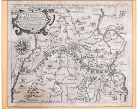
Rheinberg, On
01.01.1633 (do 10.01.1633)This engraving was made to resemble a map. The river Rhine flows on the right side, the Moselle on the left. There is a canal between the two rivers with eleven small fortresses. There is an ornamental cartouche with a Latin inscription at the top left with an inscription, which explains that the Archduchess Isabella of Austria, the widow of Archduke Albert and Governor of the Netherlands, ordered the canal construction. An orienteering compass showing cardinal directions is on the left.
Signature: Not available
Autor: Unknown
Original name: Eigentliche Abbildung der newen Fahrt, welche aus dem Rhein unter Rheinberg bisz in die Maesz unter Venlo angefangen und bereit bisz an die Stadt Geldern sampt 11 Forten fertig ist.
Katalogová čísla: Collection Český Šternberk, kód: 203/184
The canal connecting the Rhine and the Moselle depicted and described in the picture has not been preserved and it is not mentioned in any appropriate literature or on maps. However, it is known that waterways were constructed in Belgium and the Netherlands as early as the 16th and the 17th centuries. After the death of her husband, the Archduchess Isabella Clara became the Governor of the Netherlands on 18 July 1621. As a daughter of Phillip II of Spain, she was the Spanish Infanta and married the Archduke Albert of Austria on 1 April 1599. She died on 29 November 1633, immediately after the construction of the depicted canal.
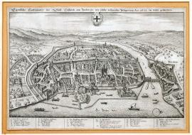
Kostnice, On
01.01.1633 (do 31.12.1633)The print depicts the town from the birds-eye view. There are boats on the lake. An orienteering compass is on the right. The river Rhine flows through some hills in the background. The coat-of-arms of the town with a cross is in the sky. The stated German text is placed above the picture; the caption 1–27 is below it.
Signature: Not available
Autor: Unknown
Original name: Eigentliche Contrafactur der Statt Constantz am Bodensee wie solche währender Belägerung Anno 1633 im wesen gestanden.
Katalogová čísla: Collection Český Šternberk, kód: 214/312
The General Gustav Hron commanded the Swedish army in the West Germany following the death of the King Gustav Adolph in the Battle of Lützen. After a couple of successful battles (for instance in Wieseloch, Benfeld etc.), Horn also besieged Konstanz on Bodensee Lake, one of the Imperial outposts in the West Germany. However, when the Imperial General Aldringen appeared in Swabia and conquered the town of Biberach after a few successful attempts, Horn quickly withdrew from Konstanz afraid that the Imperial regiments might block his access to the main Swedish army. Thus, Konstanz also remained Imperial.
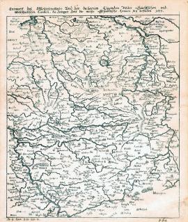
On
01.01.1633 (do 31.12.1633)This is rather a primitively drawn map of the territory between the Weser and the Rhine, which definitely cannot be considered as corresponding with the real topography of the area. The above-stated German text is placed above the map.
Signature: Not available
Autor: Unknown
Original name: Entwurff desz Weserstrohmbs und der daherum ligenden Nider Sächsischen und Westphälischen Landen da jetziger Zeit die meiste schwedische Armeen sich befinden 1633.
Katalogová čísla: Collection Český Šternberk, kód: 215/90
The war was fought on an extensive territory between the rivers Weser and the Rhine throughout the entire year 1633. The war was lengthy at these times, due to continuous official as well as secret negotiations between Wallenstein and the enemy. The most important events of this period were the military actions carried out by the Duke Bernhard of Saxon-Weimar, the conquest of Regensburg by the Swedes, the Battle of Oldendorf and the Aldringen’s march through Swabia. Majority of these events took place on the territory shown on this engraving. However, the geographical accuracy of the map is very vague indeed.
Mohuč, On
01.01.1633 (do 31.12.1633)In the foreground of this large portrait of Mainz is depicted its suburb Cassel and the river Rhine spanned by a bridge. Nearby is a square fortification wall. The picture of the town is picturesque and done out very thoroughly. There is an inscription above the town: ‚Archiepiscopalis Maguntia‘, and its coat-of-arms. The caption 1 – 36 is lower down.
Signature: M. Merian ad viv. delineavit et sculpsit.
Autor: Merian Mateus, mědirytec a nakladatel ve Frankfurtu nad Mohanem
Original name: Wahre Bildnuss der Statt Maintz sampt den newen Schantzen, Schiffbrucken und Leger wie die selbe voriger Zeit im Wesen stund. Anno 1633.
Katalogová čísla: Collection Český Šternberk, kód: 216/298
Mainz – the seat of the archbishop was once an independent free state. The Mainz archbishop was one of the spiritual electorates. The Swedish occupied the town on 13 December 1631. It was shortly after the Battle of Breitenfeld, when the Swedish regiments flooded the entire West Germany. The Swedish remained in the town until 1635. Then, after the Imperial army’s victory at Nördlingen, the Swedish started loosing many of their previously held positions.
Rheinberg, On
13.05.1633On the left of this large copper engraving is a meander of the river Rhine with the city of Rheinberg on its banks. There is a system of waterways, canals, various fortifications, trenches and army camps in the surroundings. There is a scale map of the territory at the bottom left. Above it there is a figure of a fisherman holding a board with another scale. The above-stated Latin text is placed in an ornamental cartouche at the top left, opposite is an unrolled ribbon banner with the caption 1-20. A profile of the fortification trenches including the parameters is depicted at the bottom right.
Signature: Amsterodami ex officina Johannis Blaev.
Autor: Blaev Jan, nakladatel v Amsterodamu
Original name: Obsidio Rhinbercae ad vivum expressa cum suis dimensionibus ex mandato Excellentissimi Frederici Henrici Nassovii Principis. Auraici opera celebris et ingeniosi Artificis Petri Manteau et Jacobi Culen-burgh, Anno 1633.
Katalogová čísla: Collection Český Šternberk, kód: 204/431
The Duke Frederick Henry of Orange-Nassau took over the state and military issues of the Netherlands after the death of his brother in the 1720s. For his skilful and successful ruling, he was greatly admired as a statesman, a diplomat and a general. He led a successful war campaign against the Spanish, who were defending their old domains in the Holland part of the Netherlands (present-day Belgium), conquering the cities of Herzogenbusch and Venlo one by one, including the important fortress of Maastricht. The conquest of the city and fortress of Rheiberg, held by the Imperial-Spanish army, on 13 May 1633 was one of his military successes.
Memmingen, On
04.06.1633This picture is very delicately engraved. The battle of the two regiments is just commencing at the top right near the town of Memmingen. The river Iller flows nearby. There are also several villages depicted with their names marked. At the bottom centre is the town of Babenhausen, connected with Memmingen by a path. A convoy of carriages is passing along the path, the coachmen are waiving their whips in the air. The stated German text is placed in a rectangle at the top left.
Signature: Not available
Autor: Unknown
Original name: Abbildung des Treffens so königlicher Schwedischer Oberster zu rosz I. N. Delloni vor der Reichstat Memmingen in Schwaben den 4. Juni 1633 Jahrs gehalten und mit wenig Volck obgesieget.
Katalogová čísla: Collection Český Šternberk, kód: 204a/482D
Following the death of the Swedish King Gustav Adolph in the Battle of Lützen, the Swedish army was commanded by the Chancellor Axel Oxenstierna. His best generals were Bernhard of Saxon-Weimar and Gustav Horn. The Imperial army, positioned in the West Germany, was commanded by General Aldringen, responsible to the Chief Commander Wallenstein, who was with the main army in Silesia at that time. There were no important battles fought at this time, as Wallenstein‘s preferred secret treacherous negotiations with the enemy to fighting. The depicted battle, won by a small Swedish regiment commanded by Colonel Delloni over the Imperial regiment at Memmingen in Swabia on 4 July 1633, was fought during this period.
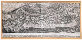
Oldendorf, On
28.06.1633 (do 08.07.1633)The Battle of Oldendorf fills up the entire area of this large picture. Various contemporary military scenes are depicted in the bottom foreground. There is even outlined an oblong formation of Swedish regiments, typical for the Thirty Years‘ War fights. Swedish as well as Imperial battle slogans are inscribed on an unrolled ribbon banner. Below the picture is the caption 1-79.
Signature: Not available
Autor: Unknown
Original name: Representatio pugnae qua illustr. Lüneburgensium dux Georgius, generalis svecus et campimarschallus Kniphusius comit. de Gronsfeld et Merode generales caesareanos 28. Juni / 8. Juli Anno 1633 prope oppidum Oldendorp ad Visurgim felicissimae debellavit.
Katalogová čísla: Collection Český Šternberk, kód: 206/329
At the time when Wallenstein took his regiments to the Upper Palatinate (west of the town of Cheb) and Bernhard of Saxon-Weimar concentrated his army in Bavaria, Axel Oxenstierna, the Swedish Lord High Chancellor and the General of the Swedish army after the death of Gustav Adolph, ordered the Duke George of Brunswick-Lüneburg and the Field Marshal Knyphousen to take their armies to the river Weser, as there was no longer any danger from the Duke of Lorraine. During this strategic move the Swedish met the Imperial army under the command of Generals Gronsfeld and Merode at Oldendorf near Hameln in Hesse. A big and bloody battle broke out and it was won decisively by the Swedish army. Approximately 5000 Imperial soldiers died on the battlefield and further 2500 were captured. 13 artillery guns, 70 military standards and all the food and ammunition supplies were seized too. The General Merode was seriously wounded and died soon after in Cologne on the Rhine. After this victory the Swedish spread all over the Westphalia.
Oldendorf, On
28.06.1633 (do 08.07.1633)The bizzare retreat of the Imperial army from the battle fought on 28 June / 8 July 1633 near Oldendorf.
1. Major General Böninghausen,
2. Count General of Gronsfeld and
3. Colonel Gottfried of Geleen from Wachtendong, Commander in Wolffenbütell. Printed in the year 1633.
There are three figures depicted under this title:
1. The Major General Böninghausen is galloping away,
2. The General Gronsfeld is carried away on a piece of wood by two soldiers,
3. The Field Marshal Geleen is running away as a common soldier.
There is a satirical verse under each figure poking at the way they are escaping.
This is a propaganda leaflet issued by the Protestants, which mocks the hasty flight of the Imperial commanders from the Battle of Oldendorf in 1633.
Signature: Not available
Autor: Unknown
Original name: Wunderbare Retirada der Kayserischen ausz dem bey Oldendorff den 28. Juni, 8. Juli 1633 beschehenen Treffens.
Katalogová čísla: Collection Český Šternberk, kód: 207/81
At the time when Wallenstein took his regiments to the Upper Palatinate (west of the town of Cheb) and Bernhard of Saxon-Weimar concentrated his army in Bavaria, Axel Oxenstierna, the Swedish Lord High Chancellor and the General of the Swedish army after the death of Gustav Adolph, ordered the Duke George of Brunswick-Lüneburg and the Field Marshal Knyphousen to take their armies to the river Weser, as there was no longer any danger from the Duke of Lorraine. During this strategic move the Swedish met the Imperial army under the command of Generals Gronsfeld and Merode at Oldendorf near Hameln in Hesse. A big and bloody battle broke out and it was won decisively by the Swedish army. Approximately 5000 Imperial soldiers died on the battlefield and further 2500 were captured. 13 artillery guns, 70 military standards and all the food and ammunition supplies were seized too. The General Merode was seriously wounded and died soon after in Cologne on the Rhine. After this victory the Swedish spread all over the Westphalia.
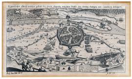
Hameln, On
01.07.1633 (do 31.07.1633)The heavily fortified town of Hameln is in the centre of the print. Above the town flows the river Weser spanned by two bridges, nearby is the small river Hammel. The town itself is protected by bulwark and various fortification constructions and surrounded by the troops of the enemy. A forest is at the background. There are two figures, of a cavalryman and a soldier, in the foreground. There is a square banner with the caption A-D on the right.
Signature: Not available
Autor: Unknown
Original name: Eigentlicher Abriss welcher Gestalt die Stadt Hameln von Ihrer Fürstl. Gnaden Herzog Georgen von Lüneburg belägert und endlich durch Uibergebung eingenommen worden.
Katalogová čísla: Collection Český Šternberk, kód: 208/83
The situation of the town of Hameln occupied by the Imperial army became unbearable following the devastating defeat of the Imperial troops at the Battle of Oldendorf on 8 July 1633. John George Duke of Brunswick-Lüneburg besieged Hameln as early as in July 1633 and the garrison agreed to give the town up without any serious fight.
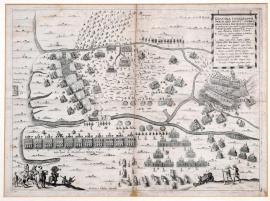
Oldendorf, On
08.07.1633The painting is divided by two rivers flowing across. A battle is raving on the central field dotted by many dead and wounded soldiers. The escape of the Imperial troops is pictured at the top. The food supply carriages are depicted in the foreground, two soldiers are standing by. At the bottom left are depicted the Duke of Lüneburg, the General Gustavson and the Field Marshal Knyphousen.
Signature: Not available
Autor: Lehausen Regnerus, mědirytec
Original name: Genuina cartagraphe praelii, quo inclytus Lüneburgensium dux Joh. Georgius, generalis svedicus etc. cum comitibus de Gronsfeld et Merode generalibus caesareanis 28. iun. / 8. iul. 1633 prope Oldendorp felicissime decertavit.
Per supremum castrorum metaforem et architektům Oluf Hanson delineata. Regnerus Lehausen sculpsit. Fredericus Hulsius excudit.
Katalogová čísla: Collection Český Šternberk, kód: 205/91
At the time when Wallenstein took his regiments to the Upper Palatinate (west of the town of Cheb) and Bernhard of Saxon-Weimar concentrated his army in Bavaria, Axel Oxenstierna, the Swedish Lord High Chancellor and the General of the Swedish army after the death of Gustav Adolph, ordered the Duke George of Brunswick-Lüneburg and the Field Marshal Knyphousen to take their armies to the river Weser, as there was no longer any danger from the Duke of Lorraine. During this strategic move the Swedish met the Imperial army under the command of Generals Gronsfeld and Merode at Oldendorf near Hameln in Hesse. A big and bloody battle broke out and it was won decisively by the Swedish army. Approximately 5000 Imperial soldiers died on the battlefield and further 2500 were captured. 13 artillery guns, 70 military standards and all the food and ammunition supplies were seized too. The General Merode was seriously wounded and died soon after in Cologne on the Rhine. After this victory the Swedish spread all over the Westphalia.
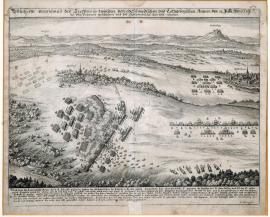
Pfaffenhofen, On
31.07.1633The battle is depicted in the left part third of the painting. The town of Pfaffenhofen is on the right, the Lichtenberg castle is atop a hill in the background, and a bit further on is the village of Rinkelsdorf. The caption A-N with appropriate explanations is below the painting.
Signature: M. Merian fecit.
Autor: Merian Mateus, mědirytec a nakladatel ve Frankfurtu nad Mohanem
Original name: Wahrhaffte verzeichnusz des Treffens so zwischen den Schwedischen und Lothringischen Armeen den 31. Julli Anno 1633 bei Pfaffenhouen geschehen und die Schwedischen das feld erhalten.
Katalogová čísla: Collection Český Šternberk, kód: 209/327
There was certain stagnation in the fights during the period between the death of the Swedish King Gustav Adolph in the Battle of Lützen in November 1632 and the assassination of Wallenstein in the town of Cheb in February 1634. This was mainly caused by the fact that Wallenstein was busy negotiating secretly and intensively with the enemy. However, the Swedish were not very active either as they needed to rest after several bloody fights and the loss of their king and general. However, some local military operation took place away from the main battlefields, mostly along the upper stream of the Rhine. The Swedish Commander Count Otto Louis of Rhineland occupied the Austrian ‚forest towns‘ in June 1633 and also besieged the town of Breisach. On the 31 July 1633 the Swedish commander Count Palatine Christian of Birkenfeld defeated at this place Charles of Lorraine, who first gathered his troops near the Alsace town of Zabern and then moved to Pfaffenhofen. The town of Pfaffenhofen lies approximately 35 km west of Strasbourg.
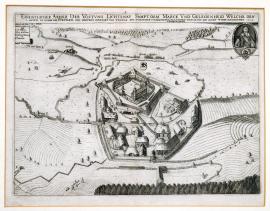
Lichtenau, On
01.08.1633 (do 24.08.1633)The painting depicts the Lichtenau fortress with its surrounding situated approximately 20 km southwest of the town of Ansbach in Bavaria. The river Resa is painted on the print. A dark forest lies in the foreground. The town’s coat-of-arms is above Lichtenau, a portrait of the Count John Jacob Thurn with his coat-of-arms lies opposite. The caption A-F is at the top left.
Signature: Not available
Autor: Unknown
Original name: Eigentlicher Abrisz der Vöstung Lichtenau sampt dem Marck und Gelegenheit welche dero 1. Augusti in Namen ihr. Fürstlich. Gna. Hörtzog Bernhart von Weinmar etc. durch den jungen Grafen von Thurn ist belägert worden und den 24. dis mit Accort wieder eingenommen. 1633.
Katalogová čísla: Collection Český Šternberk, kód: 210/225a
There was a relative ceasefire at the main battlefields of the war (in the Central Germany) between the battle of Lützen and the Cheb assassination. At this time, Bernhard of Weimar, who became the Chief Swedish Commander after the death of the Swedish King, focused on local military operations in Bavaria. He also besieged the town and fortress of Lichtenau on 1 August and soon after his subordinate, the young officer Count John Jacob of Thurn-Velsassina, conquered the fortress with the Imperial garrison. It was given up upon agreement.
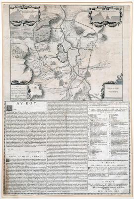
Nancy, On
25.09.1633This very delicately done copper engraving depicts the town of Nancy and its surrounding. The enemies’ trenches are positioned in a large curve around the town. There are ornamental cartouches at the top left and right showing cross-sections of fortifications constructions; the scale is at the bottom right. Below the painting are: 1. A dedication to the King Louis XIII. from R. Disiette
2. A description of the siege of Nancy marked A – Z and praising Louis XIII.
3. A topographical description of the siege.
4. A sonnet praising the heroic conquest of Nancy.
Signature: A Paris chez Melchior Tavernier.
Autor: Tavernier Melchior, rytec, tiskař a nakladatel v Paříži
Original name: La siége de Nancy
Katalogová čísla: Collection Český Šternberk, kód: 211/419
After the suppression of internal uprisings caused by the rebellions French nobility unwilling to yield to the powerful chancellor of Louis XIII, the Cardinal Richelieu turned his attention abroad. First of all, he tried to weaken the influence and power of the Holy Roman Empire at the eastern borders of France. Mostly in Lorraine, the domains of the Emperor reached right into the French lands and the bishoprics of Metz, Toul and Verdun fell under the jurisdiction of the Empire. France dealt with these political intentions by war and most of the towns, including Trier, submitted to the French dominance voluntarily. Even the Cologne Archbishop was forced to seek the ‚protection‘ of the King Louis XIII. The conquest of the town of Nancy by Louis XIII on the 25 September 1633 was part of these military operations.
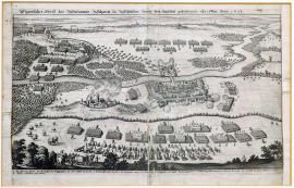
Steinov, On
12.10.1633The picture is divided by the river Oder. Burning Stein lies to the left above the Oder, there is the so-called Stein fortification along both banks of the river surrounded by the Imperial army formations. There are horse carriages in the left foreground with one cavalryman. The stated German text is located above the picture, while the caption A – I is placed below it.
Signature: Not available
Autor: Unknown
Original name: Eigentlücher Abrisz der Steinawer Schantz in Schlesien sampt dem daselbst gehaltenen Treffen Anno 1633.
Katalogová čísla: Collection Český Šternberk, kód: 212/334
Following the battle of Lützen in November 1632, Wallenstein withdrew his army onto the Saxon and Silesian territory. Meanwhile the fights between smaller Swedish and Bavarian troops went on in the Southwest Germany. In the line with his treacherous motives that influenced his indecisive strategic and political opinion, Wallenstein signed a short-term truce with the enemy, which ended on 21 September 1633. Therefore, trying to avoid a battle with the strong Swedish-Saxon army, Wallenstein chose a trick. He spread news about sending his General Piccolomini with a large regiment to conquer Torgava and cross the Elbe. Upon hearing the news, Saxon General Arnimov immediately separated his Saxon regiments from the Swedish ones and hurried to protect the endangered Brandenburg. Meanwhile Wallenstein’s army stood idly at the foot of the Lusatia Mountains waiting for Arnimov to leave. As soon as that happened, they immediately marched to the Oder. The Swedish waited near the town of Stein. Wallenstein’s officer Count Schaffgotsch crossed the Oder with 8000 Imperial mounted cavalry soldiers turning thus the Swedish cavalry onto themselves and took a position on the right bank of the river opposite the Swedish camp. At the same time, Wallenstein appeared with his regiment at Stein on the left bank of the Oder. Thus the 5000 Swedish soldiers were completely surprised and surrounded by the Imperial regiments counting about 30000 men with 70 cannons aiming at them. Wallenstein allowed the Swedish commanders, the older Count Thurn and the younger General Duval only 30 minutes to consider his conditions of capitulation. Unavoidably, under these circumstances the Swedish capitulated. With his overconfident magnanimity, Wallenstein sat all the Swedish generals, colonels and commanders free. However, he recaptured Thurn and Duval later on, forcing the former to issue an open letter to all commanders of occupied places to surrender to Wallenstein. Against the will of Vienna, he let Thurn go eight days later. Duval escaped from the capture himself.
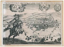
Řezno, On
15.11.1633There is a portrait of the Duke of Weimar on a horse holding the Marshal baton in his hand in the left foreground of the etching. The town of Regensburg is on the right. The picture does not depict fully the military actions of the siege of the town, only a few smaller military scenes. There are two angels holding a Laurel wreath and branchlets in the sky and two other small angels who are holding an unrolled ribbon banner with an inscription: ‚Soli Deo Gloria‘. The Regensburg coat-of-arms (two crossed keys) is in the corner of the print.
Signature: Not available
Autor: Unknown
Original name: Belägerung und Eroberung der Statt Regensburg an der Donaw, durch Ihr. Fürstl. G. Hertz. Bernhardten vom Weym. Zu anfangdes Winthers monats 1633 verrichtet.
Katalogová čísla: Collection Český Šternberk, kód: 213/103
The command of the political and military matters was taken over by the Swedish Lord High Chancellor Axel Oxenstierna following the death of the King Gustav Adolph in the Battle of Lützen. Indeed, the matter of the army command was the upmost task of these times. The Chief Swedish General Duke Bernhard of Weimar was marching with his army from Saxony to Bavaria to help the General Gustav Horn threatened by the Bavarian regiments. Lengthy fights were typical for this phase of the Thirty Years’ War, mainly due to Wallenstein’s hesitancy and indecisiveness. He kept postponing any action to help the threatened Bavaria by his artful yet ambiguous negotiations, which oscillated between the loyalty to the Emperor and a high treason, and were mostly done to earn Wallenstein personal benefits and fulfil his political aspirations. While this was going on, nothing disturbed Bernhard of Weimar to prepare the ground for the conquest of Regensburg by the Protestants. The deed that he carried out rather easily on 15 November 1633, was undoubtedly assisted by Wallenstein’s indecisive acting, if not by his direct sabotage.
Cheb, On
25.02.1634The engraving is separated into two parts down the middle. The top part shows the assassination of the officers and supporters of the Duke of Friedland. There is a dining hall filled with many fighting and shooting men, the tables are full of food, the tablecloth is pulled off. The other part of the print portrays Wallenstein in his nightdress. He is standing in the bedroom, with a desk with a burning candle in the background. A four-posted canopy bed is in the corner of the room. Three soldiers are breaking through the door, the first one (Deveroux) is just about to stab Wallenstein with a halberd, a stabbing double-edge weapon with a long shaft. Others are armed by cords.
Signature: Not available
Autor: Unknown
Original name: Eigentliche Vorbildung der zu Eger an dem Herzogen von Friedland und etlich andern Keyserlichen Obristen und Offizieren den 15. Febr. dess 1634 Jahrs verübten Mordthat.
Katalogová čísla: Collection Český Šternberk, kód: 217/95
Upon learning about Wallenstein’s treacherous acting and his unquestionable ambition to get onto the Czech throne, the Emperor issued an order to bring him in, dead or alive. In the end, however, the assassination of Wallenstein and his supporters, Illov, Trczka, Kinský and Neumann, in Cheb on 25 February 1634, was the result of an unforeseen situation and the lack of other solutions and had been decided by the Imperial executors just before it was carried out. A banquet was organised in the Chateau of Cheb. Present were, apart from the above-stated, Wallenstein’s supporters and the Imperial Colonels Gordon and Buttler, who pretended cunningly to be friends of the Duke of Friedland. However, the Duke Francis of Saxon-Lauenburg, an admirer and a faithful friend of Wallenstein arrived suddenly and unexpectedly to the town on the same evening. The Imperial confidants perceived him an obvious threat to their plans and decided therefore to act immediately. The feast was in progress, when all of a sudden several officers and soldiers from the Buttler’s regiment burst into the dining hall, shouting:,Who supports the Emperor here?’ Immediately, Gordon and Buttler got up followed by Leslie, and called out:,Vivat Ferdinand’. The intruders threw themselves on the rest of the feasting officers who left their weapons away from the table. Kinský was stabbed to death immediately. Illov died after three strikes while trying to get hold of his cord. Trczka managed to get hold of his weapon and fought back fiercely while shouting insults at Gordon. He broke Deveroux’s cord, killed two dragoons and mortally wounded Hetman Lerd receiving only three cuts onto his face as a heavy leather coat he was wearing protected his body. However, in the end, he was overpowered in the uneven fight and killed. Although Sergeant Major Neumann escaped into the kitchen he too was chased and killed. The bloody event took place at 8 pm, mostly undisturbed, because of a strong wind that howled down all the noise of fighting. Hetman Deveroux and six men armed with halberds then went to Wallenstein’s lodgings. Wallenstein was just getting ready for bed when he heard the unusual noise in the town and the laments of Countesses Kinská and Trczka over their dead husbands. Just as he called up to his guards outside the chamber: ‘What is going on’, the Deveroux’s men overpowered them and got into Wallenstein’s bedroom. Wallenstein stood in his pyjamas near his bed. Deveroux, with his halberd ready, shouted at the duke. ‘You are a scoundrel. You must die!’ Wallenstein did not answer. Once again, Deveroux shouted: ‘You must die!’, and stubbed Wallenstein into his chest, killing him instantly.
On
25.02.1634There is a portrait of Wallenstein with the contemporary pointed beard and moustache. He is wearing a wide upright collar and a sash over his chest. There are four ovals with other depictions: The banquet in the Cheb Chateau upon the arrival of the murderers. One of them, possibly Gordon, is shouting:,Vivat casa d’Austria!’. The assassination of the participants of the banquet - Kinský, Trczka, Illov and Neumann. The assassination of Wallenstein in his bedroom by the Hetman Deveroux. The drugging of the dead bodies with soldiers and one colonel with a stick standing by. There is a long German text below these drawings that describes the event into details; however from the point of view of the Imperial movement. The mention of the fact that Duke of Saxon-Lauenburg arrived to Cheb on the same evening with a larger group of soldiers to protect Wallenstein is noteworthy.
Signature: Daniel Manasser Bürger & Kupferstecher von Augspurg, jesiger Zeitt zur Grätz
Autor: Unknown
Original name: Wahre Abconterfech desz weilandt Alberti von Wallenstain gewesten Khayserischen feldt-Generalissimi, Sowol auch wass gestalt er sambt 4 anderen Rebellen umb vorgehabten Maynaydigen Conspiration zu Eger im Jahr 1634 den 25. Februari umbgebracht worden.
Katalogová čísla: Collection Český Šternberk, kód: 218/104
Upon learning about Wallenstein’s treacherous acting and his unquestionable ambition to get onto the Czech throne, the Emperor issued an order to bring him in, dead or alive. In the end, however, the assassination of Wallenstein and his supporters, Illov, Trczka, Kinský and Neumann, in Cheb on 25 February 1634, was the result of an unforeseen situation and the lack of other solutions and had been decided by the Imperial executors just before it was carried out. A banquet was organised in the Chateau of Cheb. Present were, apart from the above-stated, Wallenstein’s supporters and the Imperial Colonels Gordon and Buttler, who pretended cunningly to be friends of the Duke of Friedland. However, the Duke Francis of Saxon-Lauenburg, an admirer and a faithful friend of Wallenstein arrived suddenly and unexpectedly to the town on the same evening. The Imperial confidants perceived him an obvious threat to their plans and decided therefore to act immediately. The feast was in progress, when all of a sudden several officers and soldiers from the Buttler’s regiment burst into the dining hall, shouting:,Who supports the Emperor here?’ Immediately, Gordon and Buttler got up followed by Leslie, and called out:,Vivat Ferdinand’. The intruders threw themselves on the rest of the feasting officers who left their weapons away from the table. Kinský was stabbed to death immediately. Illov died after three strikes while trying to get hold of his cord. Trczka managed to get hold of his weapon and fought back fiercely while shouting insults at Gordon. He broke Deveroux’s cord, killed two dragoons and mortally wounded Hetman Lerd receiving only three cuts onto his face as a heavy leather coat he was wearing protected his body. However, in the end, he was overpowered in the uneven fight and killed. Although Sergeant Major Neumann escaped into the kitchen he too was chased and killed. The bloody event took place at 8 pm, mostly undisturbed, because of a strong wind that howled down all the noise of fighting. Hetman Deveroux and six men armed with halberds then went to Wallenstein’s lodgings. Wallenstein was just getting ready for bed when he heard the unusual noise in the town and the laments of Countesses Kinská and Trczka over their dead husbands. Just as he called up to his guards outside the chamber: ‘What is going on’, the Deveroux’s men overpowered them and got into Wallenstein’s bedroom. Wallenstein stood in his pyjamas near his bed. Deveroux, with his halberd ready, shouted at the duke. ‘You are a scoundrel. You must die!’ Wallenstein did not answer. Once again, Deveroux shouted: ‘You must die!’, and stubbed Wallenstein into his chest, killing him instantly.
On
25.02.1634There are 4 separated pictures on the copper engraving showing the following scenes: 1. The forced entry of the armed unit into the Cheb Chateau and the fight in the kitchen. 2. The assassination of Kinský, Trczka, Illov and Neumann at the feat. 3. The assassination of Wallenstein in his bedroom by the Hetman Deveroux. 4. The Wallenstein’s body is carried out to the courtyard. There is an inscription among these scenes:,Alberti ducis Fridlandini militiae caesareanae generalissimi et aliorum quorundam ducum et officiorum caedes, Egrae die 15. Februar. anni 1634.‘. There is an extensive three-column German text below the picture part of the print, which comments the Cheb assassination from the point of view of Wallenstein’s supporters.
Signature: M. Merian fecit.
Autor: Merian Mateus, mědirytec a nakladatel ve Frankfurtu nad Mohanem
Original name: Eigentliche Vorbildung und Bericht welcher Gestalt der Keyserliche General Hertzog von Friedland beneben etlich anderen Obristen und Officieren zu Eger hingerichtet worden den 15. Feber 1634.
Katalogová čísla: Collection Český Šternberk, kód: 219/224
Upon learning about Wallenstein’s treacherous acting and his unquestionable ambition to get onto the Czech throne, the Emperor issued an order to bring him in, dead or alive. In the end, however, the assassination of Wallenstein and his supporters, Illov, Trczka, Kinský and Neumann, in Cheb on 25 February 1634, was the result of an unforeseen situation and the lack of other solutions and had been decided by the Imperial executors just before it was carried out. A banquet was organised in the Chateau of Cheb. Present were, apart from the above-stated, Wallenstein’s supporters and the Imperial Colonels Gordon and Buttler, who pretended cunningly to be friends of the Duke of Friedland. However, the Duke Francis of Saxon-Lauenburg, an admirer and a faithful friend of Wallenstein arrived suddenly and unexpectedly to the town on the same evening. The Imperial confidants perceived him an obvious threat to their plans and decided therefore to act immediately. The feast was in progress, when all of a sudden several officers and soldiers from the Buttler’s regiment burst into the dining hall, shouting:,Who supports the Emperor here?’ Immediately, Gordon and Buttler got up followed by Leslie, and called out:,Vivat Ferdinand’. The intruders threw themselves on the rest of the feasting officers who left their weapons away from the table. Kinský was stabbed to death immediately. Illov died after three strikes while trying to get hold of his cord. Trczka managed to get hold of his weapon and fought back fiercely while shouting insults at Gordon. He broke Deveroux’s cord, killed two dragoons and mortally wounded Hetman Lerd receiving only three cuts onto his face as a heavy leather coat he was wearing protected his body. However, in the end, he was overpowered in the uneven fight and killed. Although Sergeant Major Neumann escaped into the kitchen he too was chased and killed. The bloody event took place at 8 pm, mostly undisturbed, because of a strong wind that howled down all the noise of fighting. Hetman Deveroux and six men armed with halberds then went to Wallenstein’s lodgings. Wallenstein was just getting ready for bed when he heard the unusual noise in the town and the laments of Countesses Kinská and Trczka over their dead husbands. Just as he called up to his guards outside the chamber: ‘What is going on’, the Deveroux’s men overpowered them and got into Wallenstein’s bedroom. Wallenstein stood in his pyjamas near his bed. Deveroux, with his halberd ready, shouted at the duke. ‘You are a scoundrel. You must die!’ Wallenstein did not answer. Once again, Deveroux shouted: ‘You must die!’, and stubbed Wallenstein into his chest, killing him instantly.
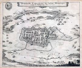
Memmingen, On
01.03.1634 (do 31.03.1634)The siege of Memmingen is depicted in the centre of the print. The river Iller and the stream Buxach flow nearby. There is a main tent of the Swedish Marshal Gustav Horn on the bank of the river at the top right. The above-stated text is above the picture in an oblong cartouche, the coat-of-arms of Memmingen is on the left, with a laurel wreath wrapped around it. The engraving is remarkable for its delicate work.
Signature: Not available
Autor: Unknown
Original name: Wahrhaffte Contrafactur der Statt Memmingen sampt der Belagerung Anno 1634.
Katalogová čísla: Collection Český Šternberk, kód: 221/339
In the first years after the death of Gustav Adolph at Lützen the Swedish military campaigns were planned by Duke Bernhard of Weimar, Field Marshal Gustav Horn and Chancellor Oxenstierna. However, their strategic opinions were usually dissimilar, which caused disagreements. Bernhard of Weimar intended a campaign to the hereditary Austrian lands, Oxenstierna and his son-in-law Gustav Horn thought it more important to fortify and secure the conquered lands. Later Bernhard of Weimar asked Horn to help him conquering the town of Amberg. Horn, however, refused and stayed in the Upper Swabia, which he was busy occupying. His stance was in the line with the opinion of Chancellor Oxenstierna, who also did not consider the conquest of Amberg a good reason for intervention. During his local operations in Upper Swabia Horn also besieged the town of Memmingen, occupied by the Imperial-Bavarian garrison. Memmingen is situated approx. 80 km northeast of Lake Constance. The described siege took place in the spring of 1634.
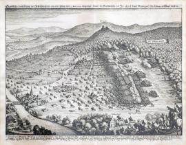
Horní Alsasko, On
02.03.1634The print depicts the battle between the Imperial and Swedish regiments. A thick forest inscribed: ‚Der Löwen Wald‘ is on the right, in the background is the Chateau Hirtenstein with the river Thur flowing below. The battle of the two armies is in the centre of the picture. The Imperial regiments are fleeing towards the left side of the print. A horse cavalry with buglers is at the bottom right. The caption 1-21 is below the picture, while the German text is above it.
Signature: Not available
Autor: Unknown
Original name: Eigentliche Vorbildung der Feldschlacht im oberen Elsasz den 2. Martii 1634 vorgangen darinn die Kayserliche von Ihr. Excel. Herrn Rheingraf Otto Ludwig geschlagen worden.
Katalogová čísla: Collection Český Šternberk, kód: 220/265
This battle took place in the Upper Alsace near Wattweiler approx. 15 km northwest of Mühlhausen near the river Thur. The Imperial regiments commanded by the Count Otto Louis of Rhineland were operating in this area at that time. The depicted battle between the two enemies took place here on 2 March 1634. The Imperial regiments were defeated.
Lehnice, On
03.05.1634Huge battle turmoil, partially veiled by the smoke from cannons, fills the entire area of the print. The town of Legnica is in the left background. There are some minor military scenes in the foreground drawn with great mastery. The German text is above the picture while the caption A – Q is below it.
Signature: Not available
Autor: Unknown
Original name: Eigentliche Abbildung des hartten Treffens so zwischen den Kays: und Chursächsischen Armeen bey Lignitz vorgangen 1634.
Katalogová čísla: Collection Český Šternberk, kód: 222/301
Following the Cheb assassination in February 1634, only weaker Imperial regiments remained in Silesia to fight the Saxons. There was also a smaller Swedish regiment. The Saxons were commanded by the famous General Arnim, who previously fought for the Imperial army. At the time of Wallenstein’s treachery, he was closely involved in the conspiracy, however he played a great role in Wallenstein’s fall later on. A battle between the Arnim’s and Imperial regiments took place on 3 May 1634 near Legnica in Silesia. The Saxons won.
Lehnice, On
03.05.1634The town of Legnica in Silesia is portrayed at the very top of the picture. Imperial soldiers are fleeing in the direction of the town. The rest of the painting is filled up by the army formations lined-up in typical squares. In the left foreground are a large tree, 2 cavalrymen, 3 soldiers, a woman with a child and a farmer holding a dog and a hen in his hands.
Signature: Not available
Autor: Unknown
Original name: Eigentlicher Entwurf des Treffens so den 3. May desz 1634 Jahrs bey Lignitz in Schlesien vorgengen, dabei die kayserische Armee von der Schwedisch. und Sächsischen geschlagen und zertrennet worden.
Katalogová čísla: Collection Český Šternberk, kód: 223/340
Following the Cheb assassination in February 1634, only weaker Imperial regiments remained in Silesia to fight the Saxons. There was also a smaller Swedish regiment. The Saxons were commanded by the famous General Arnim, who once fought for the Imperial army. At the time of Wallenstein’s treachery, he was closely involved in the conspiracy, however he played a great role in Wallenstein’s fall later on. A battle between the Arnim’s and Imperial regiments took place on 3 May 1634 near Legnica in Silesia. The Saxons won.
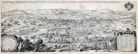
Řezno, On
15.05.1634 (do 17.07.1634)This is a large representative copper engraving, which depicts the siege of Regensburg by the Imperial army. There are mountains and the river Danube in the background. The town itself is engraved very clearly and meticulously. There are some military scenes, fortification walls, army camps etc. in the foreground. A factual and topographical captions, A-Z and 1-29, are in an ornamental banner on the right. Nearby are individual cavalrymen and musketeers carrying standards. On the left is a round ornamental cartouche with the coats-of-arms of the city council including a dedication to an unnamed burgomaster by a certain Matthias Hubert. The coat-of-arms of Regensburg, a two-headed eagle with crossed keys is at the top right. The German text cited word-for-word on the previous page is placed in the clouds over the depicted city.
Signature: Matheus Merian fecit.
Autor: Merian Mateus, mědirytec a nakladatel ve Frankfurtu nad Mohanem
Original name: Der zu Hungarn und Böheim K. M. Belagerung des h.r.freyen Statt Regenspurg, welche den 15. May Anno 1634 angefangen und den 17. Julii mit Accord vollendet worden.
Katalogová čísla: Collection Český Šternberk, kód: 229/297
After the Wallenstein’s assassination in February 1634 the Czech and Hungarian King Ferdinand, a son of Ferdinand II and the later Holy Roman Emperor Ferdinand III, took over the Chief Command of the entire Imperial army. His army advisor became the General Matthias Gallas. This change in the highest army ranks brought about a faster pace of the military campaigns, compared to the last period of the Wallenstein’s hesitant command. The new centre of the renewed fighting became Bavaria, mostly occupied by the Swedish. However, the powers of the Swedish Commander Duke Bernhard Saxon-Weimar were limited due to opinions clashes regarding the strategic planning between him and the General Gustav Horn. While the Imperial Army was moving from Bohemia to Bavaria, Bernhard Weimar was positioned in the West Germany. The advanced Imperial units commanded by Aldringen (killed near Landshut on 12 July 1634) were already threatening Regensburg, occupied by the Swedish at the time. Bernhard of Weimar was marching eastwards but before he could carry out his intention to invade the inherited Austrian lands, he heard that Regensburg, now situated behind him, capitulated on 17 July 1634 and was occupied by the Imperial army. This meant a new reunion of the two main Swedish armies commanded by Gustav Horn and Bernhard of Weimar. Moreover, the situation was quickly forwarding towards the remarkable Battle of Nördlingen, which, for the second time during the war, twisted the powers of the opposing sides, this time in favour of the Imperial-Catholic camp. (The first remarkable twist in the powers of the Thirty Years’ War came after the Battle of Breitenfeld in 1631, where the Protestants, commanded by the Swedish King Gustav Adolph, crashed the Imperial army.)
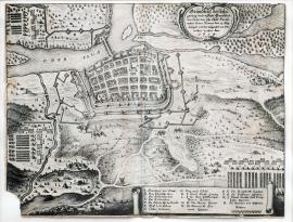
Frankfurt, On
23.05.1634The print shows the situation (ground-plan) of Frankfurt on the river Oder. The wide flow of Oder spanned by a bridge near Frankfurt cuts off symbolically the top left corner of the print. The town is surrounded by the enemy’s regiments with numerous cannon batteries and army camps. The stated German text is placed in an ornamental cartouche at the top right. The topographic and military caption A-R is above the picture part of the print, included is also a scale in rutheny.
Signature: Not available
Autor: Unknown
Original name: Grundriss der belagerung und Statt Frankfurt, wie solche von Ihr: Churf: Durchl: neben General Banner den 13. May belägert und den folgenden 23 ditoerobert worden. Anno 1634.
Katalogová čísla: Collection Český Šternberk, kód: 224/31 D
During the period after the Wallenstein’s assassination, the Saxon-Swedish regiments were positioned in the Upper Silesia and surrounding territories, operating against the relatively weaker Imperial army, which remained here after Wallenstein’s departure to the west. Among others, the Swedish-Saxon regiments besieged and conquered the town of Frankfurt on Oder, on 23 May 1634.
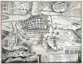
Frankfurt, On
23.05.1634The print shows the situation (ground-plan) of Frankfurt on the river Oder. The wide flow of Oder spanned by a bridge near Frankfurt cuts off the top left corner of the print. The town is surrounded by the enemy’s regiments with numerous cannon batteries and army camps. The stated German text is placed in an ornamental cartouche at the top right. The topographic and military caption A-R is above the picture part of the print, included is also a scale in rutheny.
Signature: Not available
Autor: Unknown
Original name: Grundriss der belagerung und Statt Frankfurt, wie solche von Ihr: Churf: Durchl: neben General Banner den 13. May belägert und den folgenden 23 ditoerobert worden. Anno 1634.
Katalogová čísla: Collection Český Šternberk, kód: 225/231
During the period after the Wallenstein’s assassination, the Saxon-Swedish regiments were positioned in the Upper Silesia and surrounding territories, operating against the relatively weaker Imperial army, which remained here after Wallenstein’s departure to the west. Among others, the Swedish-Saxon regiments besieged and conquered the town of Frankfurt on Oder, on 23 May 1634.
Rheinfelden, On
01.07.1634 (do 31.08.1634)The town of Rheinfelden with its high church spire is outlined in the centre of the engraving. Outside the town is: ‚Herr Gen. Maior Exc. Reingraff Johann Philips quartier‘, and nearby to the right: ‚ Auszug der Kayserlichen‘. There are mountain ridges in the background. The river Rhine flows across the painting. Army camps and cannon batteries are in the foreground. There are even ballistic tracks of the cannonballs falling on the town outlined. In the left foreground are three cavalrymen.
Signature: Not available
Autor: Unknown
Original name: Eigentliche Delineation der Festung Rheinfelden, wie dieselbe von den Schwedischen belägert und eingenommen worden. 1634.
Katalogová čísla: Collection Český Šternberk, kód: 227/29D
Bernhard Saxon-Weimar, Marshal Gustav Horn and Chancellor Oxenstierna fell apart at the beginning of 1634 over their different opinions regarding the planning of military campaigns. Bernhard Saxon-Weimar intended to invade the inherited Austrian lands, while Horn and the Swedish Chancellor first wanted to ensure properly their positions in the conquered territories. Gustav Horn carried out local operations in Swabia, among them the seize of the town of Rheinfelden, occupied by the Imperial army. These events took place still before the battle of Nördlingen fought in summer 1634.
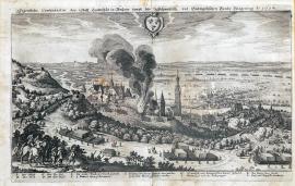
Landshut, On
12.07.1634The engraving shows the town of Landshut in a beautifully drawn countryside. A huge fire broke out in the town, covering it with clouds of smoke. The Imperial army is running away on the other bank of the river Isar. There are 2 cavalry and some infantry soldiers in the left foreground. The coat-of-arms of Landshut with three hats is drawn above the town. The caption A-L is at the bottom..
Signature: Not available
Autor: Unknown
Original name: Eigentliche Contfactur der Statt Landshut in Bayern sampt der Schwedisch und Evangelischen Bunds Belagerung Anno 1634.
Katalogová čísla: Collection Český Šternberk, kód: 226/446
There were disagreements of the military strategic opinions of Bernhard of Weimar and Gustav Horn. Horn took his troops to besiege the town of Forchheim while Bernhard of Weimar marched against the Cardinal-Infante Ferdinand of Austria, who arrived with the Spanish army. However, upon hearing the news that Regensburg was endangered Bernhard of Weimar and Horn joined their armies again on 2 July near Augspurk and together set out towards Landshut. They attacked the town on 12 July 1634. At the very moment the Imperial General Aldringen was just entering the town from the other side. A fierce fight broke out in the town, in which the Imperial regiments were crushed. The General Aldringen was hit by two bullets and drowned during the chaotic escape of the Imperial soldiers across the river Isar.
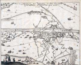
Řezno, On
16.07.1634The Danube river flows across the picture with the town of Regensburg along its banks. The river Regen, which spills into branches in the Bavarian part of the Bohemian Šumava Forest, flows into the Danube from the left side. Two cavalrymen are portrayed in the left foreground. The Imperial army camp inscribed: ‚Königs in Ungern Läger‘ is in the top left corner. The caption A-S is at the bottom left.
Signature: Not available
Autor: Unknown
Original name: Abris der belägerung der Statt Regenspurg wie solche den 16. Juli den Keyserischen mit Accord über geben worden 1634.
Katalogová čísla: Collection Český Šternberk, kód: 228/44D
Following the murder of Wallenstein in February 1634 the chief command of the Imperial army went to Ferdinand III, a son of Ferdinand II. The General Matthias Gallas was his right hand and proving himself excellently during this period of his military activities. The Imperial army sat out to march to Bavaria. One of their first important deeds was the conquest of Regensburg, which was handed over to them upon agreement on 16 July 1634. Immediately afterwards the war issues were ready for the remarkable Battle of Nördlingen, which meant a completely new twist in the forces of the Thirty Years’ War.
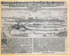
Řezno, On
28.07.1634The city of Regensburg on the river Danube with an island and two bridges lies in the background of the engraving. Its suburb with two high spires is on the left. The Swedish army is just retreating from it. A cavalry regiment is at the bottom right. A small banner with the inscription: ‚Bischofspalast‘ is placed above it. The coat-of-arms of the city (two crossed keys) and an inscription: ‚Ratisbona- Regenspurg‘ is in the sky over the city.
Signature: Not available
Autor: Unknown
Original name: Abbildung und Beschreibung der Freyen Statt Regenspurg wie sie von Ihr: Fürstl: Gnaden Hertzog Bernhard von Weimar etc. einbekommen und den 18. 28. July 1634 Ihrer Königlichen Majestät in Ungarn im Namen Kays. Mayt. nach etlich Monat langer Belägerung mit gutem Accordo widerum übergeben worden.
Katalogová čísla: Collection Český Šternberk, kód: 230/362
After the Wallenstein’s assassination in February 1634 the Czech and Hungarian King Ferdinand, a son of Ferdinand II and the later Holy Roman Emperor Ferdinand III, took over the Chief Command of the entire Imperial army. His army advisor became the General Matthias Gallas. This change in the highest army ranks brought about a faster pace of the military campaigns, compared to the last period of the Wallenstein’s hesitant command. The new centre of the renewed fighting became Bavaria, mostly occupied by the Swedish. However, the powers of the Swedish Commander Duke Bernhard Saxon-Weimar were limited due to opinions clashes regarding the strategic planning between him and the General Gustav Horn. While the Imperial Army was moving from Bohemia to Bavaria, Bernhard Weimar was positioned in the West Germany. The advanced Imperial units commanded by Aldringen (killed near Landshut on 12 July 1634) were already threatening Regensburg, occupied by the Swedish at the time. Bernhard of Weimar was marching eastwards but before he could carry out his intention to invade the inherited Austrian lands, he heard that Regensburg, now situated behind him, capitulated on 17 July 1634 and was occupied by the Imperial army. This meant a new reunion of the two main Swedish armies commanded by Gustav Horn and Bernhard of Weimar. Moreover, the situation was quickly forwarding towards the remarkable Battle of Nördlingen, which, for the second time during the war, twisted the powers of the opposing sides, this time in favour of the Imperial-Catholic camp. (The first remarkable twist in the powers of the Thirty Years’ War came after the Battle of Breitenfeld in 1631, where the Protestants, commanded by the Swedish King Gustav Adolph, crashed the Imperial army.)
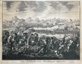
On
27.08.1634A fight of cavalries with relatively large figures is depicted in the foreground. The main battle and the city of Nördlingen with its church spire are in the background. Thick clouds of smoke and dust are hanging over the fighting turmoil. There is a cavalryman carrying a standard with the Imperial eagle in a group of figures to the left. The landscape in the background ends at high mountains. The entire composition of the picture characterises a later period than the first half of the 17th century.
Signature: Not available
Autor: Unknown
Original name: Die Schlacht bei Nördlingen Anno 1634.
Katalogová čísla: Collection Český Šternberk, kód: 231/319
The battle of Nördlingen fought on 27 August 1634 meant a serious twist into the powers of the two fighting religious movements and opposed armies. Once again, the Imperial-Catholic camp was winning. The command of the Swedish army went to the hands of the Duke Bernhard of Saxon-Weimar, the Marshal Gustav Horn and the Chancellor Oxenstierna after the death of the King Gustav Adolph at the battle of Lützen. However, the Duke of Weimar and Horn were never able to agree on the strategic and tactical issues. Bernhard of Weimar was a go-ahead impulsive and aggressive attacker while Horn was a careful, thoughtful and a rather passive strategist. Such contradictory military attitude of the two commanders had a tragic impact on the battle of Nördlingen as the command was united and not held by one person, as it had been during the Swedish successful fighting under the command of the King Gustav Adolph. However, some large changes at the highest ranks happened also in the Imperial army. The assassinated Wallenstein was replaced by the young Bohemian and Hungarian king Ferdinand, who later became the Emperor after the death of his father. His right hand, military advisor and the person behind the military successes was the experienced General Matthias Gallas. The young king left the command to Gallas which was a far-seeing move that largely contributed to the victory of the Imperial army. Following a full day of fierce fighting that brought many crises and unexpected twists at both sides the Swedish army was crushed. The Imperialists had 33000 men while Swedish only 26000. Field Marshal Horn was captured by the cavalry of General John of Werth while Duke Saxon-Weimar only narrowly escaped the same destiny. The Imperialists captured 170 banners and standards and 80 cannons. Not only where the losses on the Swedish side enormous but all the cavalry carriages and supplies fell into the hands of the Imperial army.
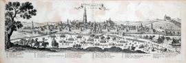
Nördlingen, On
27.08.1634The print shows the overall view of the city of Nördlingen situated in the Western Bavaria near the border with Württemberg, approx. 80 km northwest of Augsburg. There is an unrolled ribbon banner in the sky over the landscape with the French inscription stated on the previous page. There are several military regiments with carriages in the foreground. A high officer with a report giving adjutant is depicted on the left. A large tree stands nearby and there is a church on a hillock on the right. The caption A-V is below the picture. This is a copper engraving of French origin of a high artistic quality. Although there is no signature, it shows many characteristics of the engraving techniques of Jacques Callot. It is remarkable that apart from the topographical caption the position of Nördlingen and its surrounding is also given according to modern cartographic customs in the longitudes and latitudes.
Signature: Not available
Autor: Unknown
Original name: Nördlingen en Suabe Imp.
Katalogová čísla: Collection Český Šternberk, kód: 232/296
The city of Nördlingen was besieged by the Imperial army shortly before the battle started on 27 August 1634. Bernhard Saxon-Weimar arrived with his army to liberate the city from the siege and situated his army on a hill near Bopfingen, where he was joined by the Marshal Gustav Horn. The critical situation of the city garrison was growing more and more serious. In the end, their appeals for help made Bernhard of Weimar to forget Horn’s doubts, to carry out his idea and to attack the Imperial army. Horn’s advice was to postpone the attack and wait for the arrival of the Count Otto Louis of the Rhineland, for who a messenger Colonel Kratz was hastily sent. However, the Swedish army was ordered to attack the Imperial regiments besieging Nördlingen, and the battle broke out.
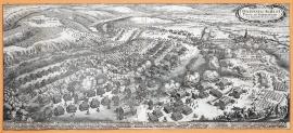
Nördlingen, On
06.09.1634This wide print depicts the Battle of Nördlingen. The Imperial army is on the right side and the Swedish on the left in a forest. The city of Nördlingen is painted nearby on the right. A small scene with a colonel and buglers is depicted in the right foreground. The entire area of the print is filled up by fighting regiments. The Latin inscription cited word-for-word on the previous page is placed in an ornamental cartouche at the top right. The caption A-Z and 1-42 is below the picture.
Signature: M. Merian fecit
Autor: Merian Mateus, mědirytec a nakladatel ve Frankfurtu nad Mohanem
Original name: Delineatio aciei et pugnae ad Nördlingam VI. Septembris Ao MDCXXXIV.
Katalogová čísla: Collection Český Šternberk, kód: 233/324
The battle of Nördlingen fought on 27 August 1634 meant a serious twist into the powers of the two fighting religious movements and opposed armies. Once again, the Imperial-Catholic camp was winning. The command of the Swedish army went to the hands of the Duke Bernhard of Saxon-Weimar, the Marshal Gustav Horn and the Chancellor Oxenstierna after the death of the King Gustav Adolph at the battle of Lützen. However, the Duke of Weimar and Horn were never able to agree on the strategic and tactical issues. Bernhard of Weimar was a go-ahead impulsive and aggressive attacker while Horn was a careful, thoughtful and a rather passive strategist. Such contradictory military attitude of the two commanders had a tragic impact on the battle of Nördlingen as the command was united and not held by one person, as it had been during the Swedish successful fighting under the command of the King Gustav Adolph. However, some large changes at the highest ranks happened also in the Imperial army. The assassinated Wallenstein was replaced by the young Bohemian and Hungarian king Ferdinand, who later became the Emperor after the death of his father. His right hand, military advisor and the person behind the military successes was the experienced General Matthias Gallas. The young king left the command to Gallas which was a far-seeing move that largely contributed to the victory of the Imperial army. Following a full day of fierce fighting that brought many crises and unexpected twists at both sides the Swedish army was crushed. The Imperialists had 33000 men while Swedish only 26000. Field Marshal Horn was captured by the cavalry of General John of Werth while Duke Saxon-Weimar only narrowly escaped the same destiny. The Imperialists captured 170 banners and standards and 80 cannons. Not only where the losses on the Swedish side enormous but all the cavalry carriages and supplies fell into the hands of the Imperial army. Bernhard Saxon-Weimar arrived with his army to liberate the city from the siege and situated his army on a hill near Bopfingen, where he was joined by the Marshal Gustav Horn. The critical situation of the city garrison was growing more and more serious. In the end, their appeals for help made Bernhard of Weimar to forget Horn’s doubts, to carry out his idea and to attack the Imperial army. Horn’s advice was to postpone the attack and wait for the arrival of the Count Otto Louis of the Rhineland, for who a messenger Colonel Kratz was hastily sent. However, the Swedish army was ordered to attack the Imperial regiments besieging Nördlingen, and the battle broke out.
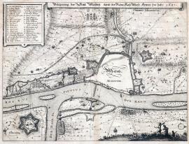
Mohuč, On
01.01.1635 (do 31.12.1635)The print depicts the map of Mainz and its surroundings during the siege of 1635. There are fortifications and walls around the town, however the place for the town itself is empty apart from the incription ‚Mayntz – Moguntia‘. Below is the river Rhine with its tributary Main. There are three islands on the Rhine. The town is surrounded by massive bulwark and there are several regiments, camps and few trees spread around. Nearby is a fortress called Gustavusburg with a star-like ground-plan. The caption A-Z and 1-10 is in a banner at the top left. The above-stated text is above the picture.
Signature: Not available
Autor: Unknown
Original name: Belägerung der Statt Mayntz durch die Röm: Kay: May: Armee im jahr 1635.
Katalogová čísla: Collection Český Šternberk, kód: 239/278
A certain military stagnation prevailed in the Protestant camp following their bloody defeat at the Battle of Nördlingen. The situation was made even worse by the opinion conflicts between Bernhard of Weimar, Gustav Horn and the Swedish Chancellor Oxenstierna. General Gallas took a great advantage of this situation gradually conquering the towns of Worms, Oppenheim, Bingen and Bachrach and surrounding the towns of Frankenthal and Mainz. However, when the Duke of Weimar with the Swedish-French army appeared suddenly, the Imperial army retreated from Mainz. Nevertheless, Gallas managed to conquer the town later on.
Rheinfels, On
01.01.1635 (do 31.12.1635)The river Rhine flows through the centre of the depicted landscape. The Rheinfels fortress on its left bank is surrounded by deep trenches of the French regiments. The French line is under the fire of the cannon batteries of the enemy, situated on the right bank of the Rhine. The above-stated German text is placed above the picture.
Signature: Not available
Autor: Unknown
Original name: Die Vestung Rheinfels wird von den Französischen Armeen vergeblich belagert.
Katalogová čísla: Collection Český Šternberk, kód: 240/415
This engraving does not state any date or factual details, therefore the depicted event cannot be reliably defined, even less though that this is undoubtedly an unimportant fight. The French regiments fought with the Swedish in 1635 against the Imperial-Bavarian army in the valley of Rhine – therefore this is likely to be one of the fights from this period of the Thirty Years‘ War. The small town of Rheinfels is situated approx. 25 km south of Koblenze.
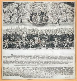
On
10.03.1635The 40 figures depicted in the picture, wearing cloaks with lace collars, are possibly portraits of the 40 hostages. There are six angels in front of them with their coats-of-arms. The city of Munich is in the background. In the clouds above the city is the Mother of God with the Baby Jesus and several angels, who are holding her cloak and her crown over her head. At her feet are the coats-of-arms of Bavaria and the city of Munich. At the sides of the Virgin Mary are 4 angels holding boards with the names of the 40 hostages. An extensive German text and some Latin prayers to the Virgin Mary thanking her for a happy return are below the picture.
Signature: Luc. Kilian F.
Autor: Unknown
Original name:
Katalogová čísla: Collection Český Šternberk, kód: 234/284
After the Swedish occupied Munich on 10 May 1632, the King Gustav Adolph decided to capture 40 respectable citizens of the city as hostages. It was done because Munich was fully devoted to its ruler the Electorate Maximilian of Bavaria and most of its citizens were Catholics. It was therefore easy to foresee a rebellion against the Protestants. The 40 abducted citizens were imprisoned in Augsburg, Donauwörth and Nördlingen, and only returned to Munich only two years and ten months later. Two of them died in captivity.
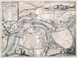
Schenkenschanz, On
18.07.1635The copper engraving depicts a part of the lower stream of the Rhine with the fortress of ‚Schenckenschantz‘. It shows many minor scenes, various fortification constructions, military camps, pastures etc. A soldier holding a long pike and several other figures, one with a backpack, are to be seen in the right foreground. Two ditch diggers are painted on the right. There is a plan of the fortress at the top right. Opposite, in an ornamental banner is the above-stated German text and the caption 1-25.
Signature: Not available
Autor: Unknown
Original name: Gelegenheit und Belagerung der berümpten Schenckenschantz im Jahr 1635 und 36.
Katalogová čísla: Collection Český Šternberk, kód: 235/406
The year 1635 saw a number of changes in the existing relationships between France and the Holy Roman Empire. France officially declared war on the Emperor and immediately started military campaigns in positions shared with the Habsburgs. A truce dividing the so-called Holland Netherland (present-day Belgium) into two parts was also signed with the Netherlands. France wanted one part of this territory while the other was left to the Netherlands under the rule of the widow of Archduke Albert, the Infanta Isabella – a daughter of the Spanish king Philip II. However, the outcome of French fights was not impressive as neither the army nor its commanders had any experience in fighting. The depicted siege of ‚Schenckenschantz‘ took place during the fights of the stated period.
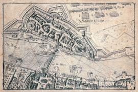
Frankfurt, On
11.08.1635The print is lacking the usual explanatory text. According to Drugulin it depicts the siege of the town of Sachsenhausen and its handover upon agreement on 11 August 1635 to the General Lamboy. The picture shows the city of Frankfurt and the river Main with Sachsenhausen spreading on its other side. A shooting regiment is crossing the bridge over the Main. A garrison is leaving Sachsenhausen.
Signature: Not available
Autor: Unknown
Original name: Frankfurt
Katalogová čísla: Collection Český Šternberk, kód: 236/101
Peace between the Electorate of Saxon John George I and the Emperor was signed in Prague in May 1635. The crushing defeat of the Swedish army at the Battle of Nördlingen completely changed the political and military situation. Under the dire consequences a considerate number of German Protestant princes agreed to the conditions dictated to the Saxons by the Emperor. Even the free Imperial cities bowed to the Emperor, including Frankfurt on Main and Sachsenhausen, occupied by a rather weak Swedish garrison, which General Lamboy was forced to leave on 11 August.
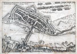
Sachsenhausen, On
11.08.1635The print depicts two cities separated by the wide river Rhine. A bridge connecting Frankfurt and Sachsenhausen is under the fire from both sides. The Swedish-French regiments are just leaving the town. There are even ballistic track of cannonballs falling upon the city marked in the print.
Signature: Not available
Autor: Unknown
Original name: Sachsenhausium Frankfurti ad Moenum suburbium cum hostilitatibus inter utrasque gestus.
Katalogová čísla: Collection Český Šternberk, kód: 237/320
The Swedish-French Alliance was shaken by the victory of the Imperial army near Nördlingen. The enemies of the Imperial camp were thus forced to retreat to the left bank of the Rhine and could not therefore prevent the conquest of Sachsenhausen on 11 August 1635 by General Lamboy.
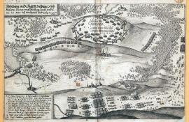
Merseburg, On
25.10.1635 (do 26.10.1635)An army camp on an elevated plain surrounded by strong fortification walls is in the centre of the picture. The small town of Mesieres and a couple of other villages and settlements are nearby. There are a couple of woods in the landscape. The Swedish-French army is marching at the bottom right. The above-stated text is in an oval banner in the top left corner of the print. The caption A-M is in a similar banner at the bottom.
Signature: Not available
Autor: Unknown
Original name: Abbildung der R: Kays: M: Veldlägers bey Mesieres, Diouze und Mörseberg sampt der Positur der Armme bey der Schweden Vorüberzug den 25. 26. Oktober 1635.
Katalogová čísla: Collection Český Šternberk, kód: 238/321
The biggest enemy of the Emperor after the Battle of Nördlingen was the Duke Bernhard of Weimar, who now had to rely on the French help as most of the German princes left the Protestant Alliance. However, due to various misunderstanding with the French commanders Bernhard could not prevent uniting of the two Imperial armies commanded by the Generals Gallas and Charles of Lorraine, who now marched together to St. Dieuze (Merseburg) in Lorraine. Both Imperial generals used this strong position and the strength of their joined forces to carry out successful attacks on the enemy, which retreated to Nancy, Lunnéville and St. Nicolas being weakened by internal struggles. However, Gallas and Charles of Lorraine soon were at conflicts of opinions too and the two armies separated again. Gallas marched via Pfalzburg to Alsace while Charles of Lorraine went to Franche-Comté, a region at the east of France on the borders with the present day Germany and Switzerland. Due to this they missed a change for a great victory at Merseburg, when the Swedish-French army passed by on 25 and 26 October 1635 within their arm’s reach.
Ehrenbreitstein, On
01.01.1636 (do 31.12.1636)The print depicts the territory around the confluence of the rivers Moselle and the Rhine with the town of Koblenz nearby. On a rather high hill on the other side of the Rhine is the Ehrenbreitstein fortress depicted accurately with the surrounding fortification constructions. There are deep-cut valleys, ravines and streams in the landscape. The German text is placed above the picture, while the caption A-R is below it.
Signature: Not available
Autor: Unknown
Original name: Die Vestung Ehrenbreitstein oder Hermanstein, und wie selbige von den Kayseris. Ploquiert und eingenommen wurde. Anno 1636.
Katalogová čísla: Collection Český Šternberk, kód: 244/294
The year 1636 was marked by the fights between the Imperial forces commanded by Gallas and Charles of Lorraine and the Swedish-French army commanded by Bernhard of Weimar and the Cardinal le Vallet. These military campaigns took mostly place on the French land. The cavalry of the Imperial General John of Werth even managed to get near Paris. It is therefore obvious that the remaining strong positions held by the French and the Swedish along the Rhine were gradually conquered by the Imperial forces. This was how the Ehrenbreitstein fortress situated on the other side of the Rhine opposite Koblenz was captured too.
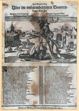
On
01.01.1636 (do 31.12.1636)The picture depicts a soldier sitting on a peasant as on a horse. Other soldiers pictured behind him are torturing the villagers in various ways. A regiment is on the left and a hilly panorama in the background. There is a small cloud in the sky with a small figure sitting on a bonfire. A two-verse German poem is below the picture part of the print. It describes the suffering of the peasants in the war promising a future revenge. There is no date on the print; however Drugulin’s catalogue places this print in the year 1636.
Signature: Not available
Autor: Fürst Paulus, nakladatel v Norimberku, obchodník s uměleckými předměty
Original name: Neiwe Bawren Klag Uber die unbarmhertzigen Bawren reuter dieser Zeit.
Günstiger Leser tritt herbey Beschaw die sltzam Reutery, Die jetziger Zeit in der Welt
von den Soldaten angestellt.
Katalogová čísla: Collection Český Šternberk, kód: 245/66
The Thirty Years‘ war caused terrible suffering and poverty to the citizens of territories affected in any way by the fights. Indeed, the peasants met the worst fate as the whole armies normally got food and horses by pillaging and plundering the countryside. This led to a complete depopulation in some parts. The peasant population of Germany and in the Czech territories decreased almost by two-thirds.
Praha, On
01.01.1636 (do 31.12.1636)This is a wide view of the city of Prague with the river Vltava spanned by a stone bridge flowing through its centre. A stylised ruin stands in the left foreground with the Strahov Monastery visible behind it. The Baroque-style cartouches drawn over the city show the coats-of-arms of Hradčany, Old and New Town and Malá Strana, the Imperial Eagle and the Czech Lion. The city quarters and important buildings are marked with names. There is a rectangular cartouche at the bottom centre with names of 20 remarkable buildings in Czech, Latin and German. The coat-of-arms of the author (Hollar) with an inscription:,Wenceslaus Hollar a Lewengrun et Bareyt hanc regni Bohemiae Metropolim, Patriam suam, ex monte Sct. Laurentii A. 1636 exactissime delineavit & aqua forti in hanc formaa aeri insculpsit, Antwerpae A. 1649.‘ is at the top. Translation: ‚Václav Hollar of Lewengrun and Bareyt painted as accurately as possible this capital city of the Bohemian Kingdom, its homeland, in the year 1636, from the hill of St. Lawrence (present day Petřín) and using the aqua fortis (the nitric acid used for etching) he etched this view into a copperplate in Antwerp, year 1649.
Signature: Not available
Autor: Hollar Václav z Práchně, český mědirytec
Original name: Praga
Katalogová čísla: Collection Český Šternberk, kód: 245A/486
It is a beautifully done well-known Hollar’s view of the city made on his visit to Prague in 1636, when he was accompanied by the Ambassador of the English King Charles I, the Lord Thomas Haward Earl of Arundel and Surrey. The colour drawing existed in the collection of Sir Rawlings in London in the 18th century. The picture was probably painted from the Schönborn Garden. It is interesting that in the title of the picture Hollar does not state the gentle postscript ‚Prachenbergensis‘ given to his family by Rudolf II in 1606, only the predictates given to him by Ferdinand III according to the birth name of his Mother Marketa of Lövengryn and Bareyt in 1630.
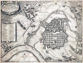
On
13.06.1636The town of Hanou is drawn from the birds-eye perspective in a meander of the river Küntzig and is divided into two parts. There are enemies‘ fortified lines, various regiments etc. in the near surroundings of the town. The river Main flows through a forested landscape in the foreground. The stated German text is in an oval cartouche at the top left. The caption A-Z and 1-15 is lower down.
Signature: Not available
Autor: Unknown
Original name: Eigentliche Delineation der vesten Statt Hanou sampt der Kays: Belagerung, wie sie von den Schweden und Landgrafen Wilhelm von Hessen entsetzet worden den 13. Juni 1636.
Katalogová čísla: Collection Český Šternberk, kód: 241/308
As the Elector John George I of Saxon was forced to sign the Peace of Prague (1635) with the Emperor due to the defeat of the Swedish at Nördlingen, many other German princes also left the military Protestant Alliance. One of the few, who remained faithful to the Swedish, was the Landgrave William of Hesse, who helped to liberate the town of Hanou on the river Maiz from the Imperial siege. This Swedish-Hesse operation against the Imperial regiment took place on 13 June 1636.
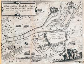
Magdeburg, On
13.07.1636The engraving depicts the river Elbe streaming out into several branches. The city of Magdeburg lies above the river. The author did not outline the centre of the city, there is only the inscription ‚Magdeburg‘. The Imperial-Saxon army fighting formations are lined-up outside the city while a relatively small Swedish garrison is leaving it from the other side. There are four mounted buglers at the bottom right. The above-stated German text is placed in an ornamental vignette in the top left corner.
Signature: Not available
Autor: Unknown
Original name: Magdeburg durch Accord von den Kayserisch und Chur-Sächsischen wieder erobert den 13. Monats Julii 1636.
Katalogová čísla: Collection Český Šternberk, kód: 242/98
The Electorate John George of Saxon started rethinking his alliance with the Swedish after the conquest of Regensburg by the Imperial forces on 17 August 1634 and, most of all, following the Battle of Nördlingen on 6 September 1634. He finally decided to change sides and support the Emperor during the peace negotiations in Prague in 1635. Obviously, the politics of this German Electorate was led primarily by his opportunistic plans. The strategic situation of the Swedish thus became critical and not even entering of France into the war against the Emperor could help to even up the powers. The Swedish retreated to the sea at the north and to the northwest and left only a couple of insignificant garrisons in the towns of the Central Germany, which were easily overpowered by the Imperial forces. This is how the city of Magdeburg, still affected by the cruel Tilly’s conquest five years ago, fell into the hands of the Imperial army. The Swedish garrison left and handed the town over voluntarily.
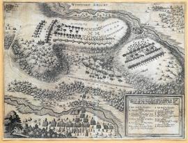
Wittstock, On
24.09.1636There is an inscription below the bottom border of the engraving:,Wittstocker Schlacht’. A small river is flowing on the right with the small town of Wittstock above it. There are two hilltops in the depicted landscape with the armies fighting atop. The fights are also depicted in the valley spreading out towards the river. The caption A-P and the above-stated text are placed below the picture part of the print.
Signature: Not available
Autor: Unknown
Original name: Eigentliche Delineation des Treffens so zwischen der Keys. Ligistisch. und Chur-Sächsischen und dann anders theils den Schwedischen Armeen bey Wittstockh den 24. September anno 1636 vorgang.
Katalogová čísla: Collection Český Šternberk, kód: 243/345
The strategic situation of the Swedish worsened considerably becoming almost critical, following the defeat in the Battle of Nördlingen and consequent exit of the Elector of Saxon and few other German princes from the Protestant Alliance. The focus of the fights moved into the area north of Saxony, where General Banner and his subordinate commanders Torstensson, Leslie, King and Stallhantsh led the Swedish army, counting 22000 men. The united Imperial-Saxon army, commanded by the Elector of Saxon himself and the General Count Hatzfeld had approx. 30000 men. Both armies met nearby the small town of Wittstock, almost 100 km northwest of Berlin. An exceptionally bloody and tough battle broke out with uneven forces on both sides for a long time. Finally, the Swedish managed to beat the opponent despite having fewer men. They seized 151 Imperial banners and standards, 35 cannons and all the supplies including the silver tableware of the Elector. A total of 1145 dead and 2245 wounded Swedes were left at the battlefield while the Imperial army lost almost 5000 men. The defeated army quickly withdrew to Magdeburg.
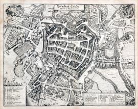
Lipsko, On
01.01.1637 (do 31.01.1637)This is a very meticulous bird’s eye view of the city. There is the streamed out river Pleisa and a number of gardens outside the city. Several Swedish regiments are attacking the city, mainly from the south. There are two coats-of-arms at the top, one of them is Saxon. The above-stated German text is on an unrolled ribbon banner above the picture. Two rectangular banners with captions A-O, P-Z and 1-14 are at the bottom left and right.
Signature: Not available
Autor: Unknown
Original name: Die Statt Leipzig sampt der Belägerung Anno 1637.
Katalogová čísla: Collection Český Šternberk, kód: 246/237
The victory of the Swedish army at Wittstock in September 1636 gave the General Banner a chance to occupy the entire Saxony, which had supported the Emperor since the victory of the Imperial forces at Nördlingen in 1634. Banner besieged Leipzig in January 1637 and tried to conquer it. However, the garrison of the town fought bravely being supported by supplies of food and men from the Saxon countryside, a move organised by Julius of Wolfersdorf. The General Gallas also arrived with his army from the West Germany later on to support the besieged city. Banner then realised it was impossible to defeat the Saxons united with the Imperial forces, stopped the siege immediately and withdrew hastily being pursued by Gallas as far as the Danish borders. Experts considered this Swedish withdrawal a remarkable strategic success from the military point of view.
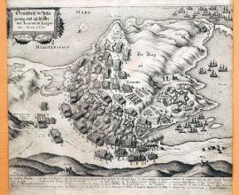
Leucate, On
01.01.1637 (do 31.12.1637)A hilly peninsula in the Mediterranean Sea near Leucat Lake is depicted on the picture. A battle between the French and Spanish is raging on the peninsula. A ship is sailing on the sea. Leucate is situated at the seaside near Perpignan. The stated German text is placed in a rectangular cartouche at the top left. The local and factual caption is below the picture.
Signature: Not available
Autor: Unknown
Original name: Grundrisz der Belägerung und Schlacht vor Leucate in Languedoc, Anno 1637.
Katalogová čísla: Collection Český Šternberk, kód: 250/256
France and Spain were in war for many years but the fighting got more intensive after the Swedish lost some of their power after the Peace of Prague (the Emperor signed a truce with the Electorate John George I of Saxon in Prague in 1635. Saxony went on supporting the Emperor followed by the majority of the German princes, leaving the Swedish isolated). In the effort to support the anti-Imperial forces, the French declared war on the Hapsburgs and sat about fighting in all shared areas. Commanded by excellent commanders (Bernhard of Weimar, Harcourt, Guebriant, Cardinal la Valett and later also Turenn, Condé etc.) the French occupied Artois, Lorraine, Alsace and Roussillon. At the same time, the Cardinal Richelieu supported Catalonians and the Portuguese in their revolt against the Madrid government. The depicted battle between the French and the Spanish near Leucate on the coast of the Mediterranean Sea in 1637 took place during this period of fighting.
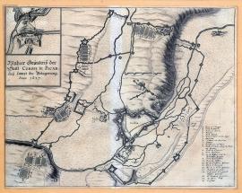
Corbie, On
01.01.1637 (do 31.12.1637)The picture depicts the rivers Ancre and Somme. On a hillock above the Somme is the fortress of Corbie, surrounded by an extensive system of fortifications. There are several army camps in the surrounding countryside. There is a cross-section detail of the fortification at the top right above the stated German test. The topographical and factual caption A-D and 1-20 is placed at the bottom right.
Signature: Not available
Autor: Unknown
Original name: Wahrer Grundrisz der Statt Corbie in Picardey sampt der Belagerung, Anno 1637.
Katalogová čísla: Collection Český Šternberk, kód: 251/346
The Spanish the Netherlands took part in the prolonged war between France and Spain, after Cardinal Infant Ferdinand, a brother of the Spanish King Phillip IV, became its governor following the death of Isabella, the widow of the Archduke Albert. This Spanish-Dutch Alliance won a couple of important fights at the beginning in the Northwest France, including the conquest of the town and fortress of Corbie, situated approx. 20 km east of Amiens. However, the luck turned later on, and the French reoccupied the lost territories including Corbie in 1637. The described copper engraving depicts this event.
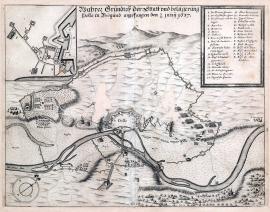
Dole, On
11.06.1637The town of Dolle (Dole on the river Doubs) approx. 50 km southeast of Dijon in France lies in the centre of the engraving. The so-called bird’s eye view is done merely schematically, however the fortifications around the town are drawn quite meticulously. The river Le Doux (Doubs) spanned by a bridge leading out of the town flows across the bottom part of the picture. There are numerous fortification constructions, army line-ups and camps around the town. There is a wide circle of trenches around the town. The background is hilly. A detail of the fortification with the enemy’s trenches is in the top left corner in a square. The caption 1-22 and A–K is at the right in a rectangular banner. There is an orienteering compass at the bottom left.
Signature: Not available
Autor: Unknown
Original name: Wahrer Grundrisz der Statt und belägerung Dolle in Burgund angefangen den 1. juny 1637.
Katalogová čísla: Collection Český Šternberk, kód: 247/286
The powers and fighting activities moved again to the side of the Imperial-Catholic movement due to the victory of Nördlingen in 1634 and the Peace of Prague signed between the Emperor and John George of Saxon. As France entered the war in 1635 fighting against the Holy-Roman Empire, the centre of the war moved into Rhineland and France. The Swedish Commander Bernhard of Weimar stood alone after some of his allies, the German princes and, most of all the Elector of Saxon, left the Protestant Alliance, and got severely dependent on the French army. However, they had only one in common – the enemy. Opinion clashes between Bernhard of Weimar and French commanders occurred and this rift was skilfully used by the Imperial armies commanded at that time by Gallas and Charles of Lorraine. The depicted siege of the town of Dolle in Burgundy by the French in June 1637 took place during this period.
Wittenweier, On
08.08.1637This copper engraving depicts a section of the upper stream of the Rhine that spills out in a forested terrain. The formation of regiments near the burning township of Wittenweyer is in the background. The Imperial soldiers are attacking the Swedish fortifications. In the foreground are some minor scenes with cavalrymen escorting the captives. The above-stated German test is above the picture, while the caption A-M is below it. Drugulin believes this engraving to be the work by M. Merian.
Signature: Not available
Autor: Unknown
Original name: Wahre Delineation der Schwedischen Schantzen und Schiffbrücken bey Rheinaw wie selbige von den Keyserischen eingenohmen worden 1637.
Katalogová čísla: Collection Český Šternberk, kód: 248/389
The great Commander of the Swedish-French Alliance Bernhard of Weimar was about to carry out his plan (of 3 years) in 1637. It involved a great invasion into the inherited Austrian lands of the Emperor. The army supported by the French forces was to move along the upper stream of the Rhine via Bavaria towards the east. However waiting in vain for the promised French help, Bernhard finally decided to go ahead with the campaign alone supported only by a fraction of the French regiments. He neared the Rhine near Rheinau in the second half of July 1637 and occupied a couple of fortifications on the right bank of the river to allow his entire army cross the river undisturbed. Charles of Lorraine stood on the other side of the river together with the brave Imperial Infantry General John of Werth, who once again did unheard of brave deeds. His cavalry carried out several aggressive attacks, even crossing the river, chasing the Swedes out of their positions. Next came several very fast movements that forced even Bernhard of Weimar himself to jump into the river hastily to save himself from a capture. Afterwards both sides hastily called reinforces, however no decisive fight took place. This battle of Rheinau took place on 8 August 1637.
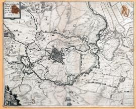
Breda, On
07.09.1637This is a map of the town of Bredy and its wide surroundings done with a great attention to detail. The fortifications of the conquerors circle the town widely. The stated German text is at the top left, below is an ornamental unrolled ribbon scroll with two coats-of-arms. Army formations as well as individual figures are painted all over the area of the print.
Signature: Not available
Autor: Unknown
Original name: Belägerung der Statt Breda durch Friedrich Heinrich Princen von Oragien, den 23. July 1637.
Katalogová čísla: Collection Český Šternberk, kód: 249/193
When the truce signed between Spain and the Netherlands in 1609 ended in 1621, the fighting was renewed. When Maurice of Orange died in 1625 the command of the army and state issues went to his brother Frederick Henry who managed to liberate the towns occupied by the Spanish: Herzogenbusch and Maastricht. Breda which had been occupied since 1625 was liberated on 7 September 1637. This is depicted on this print.
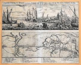
ústí řeky Šeldy, On
01.01.1638 (do 31.12.1638)The copper engraving consists of two fully separated views placed above each other. The upper picture depicts a battle on the opposite bank of the river Scheldt. There is a church on the right, several sailboats on the river and many drowning soldiers in the water. The bottom picture is done to resemble a map of the situation around the mouth of the Scheldt; there are some fortification constructions and a lot of fighting regiments. The caption 1-18 is below the pictures.
Signature: Not available
Autor: Unknown
Original name: Eigentliche Abbildung der Schantzen Caloo, Verbroek, und Feuerschen und wie solche von den Holländern befestigt und wie sie von den Spanischen wieder daraus geschlagen worden. Anno 1638.
Katalogová čísla: Collection Český Šternberk, kód: 268/313
The Governor of the Spanish Netherlands Cardinal Infante Ferdinand led a successful war against the Dutch and three French armies in 1638. In the end, he managed to force the enemy out of his land. The Dutch built several fortifications at the mouth of the Scheldt. Many soldiers drowned during the battle provoked by the Spanish attacks on these fortifications. The Spanish conquered and occupied the fortifications. This battle took place in year 1638.
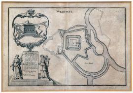
Wildstatt, On
01.01.1638 (do 31.12.1648)To the right side of the engraving there is Wildstatt castle surrounded with a dense fortification system of watercourses. Its geographic situation is unknown. The engraving rather has a character of cartographic layout or plan. In the top left part there is a decorative cartouche with a view of Wildstadt castle broken through by the artillery fire. In the lower part there is a square board in the shape of a headstone, held by two female figures with the Imperial Eagle above their heads. The board reads caption: A-M.
Signature: Inocentius de Comitibus.
Autor: Comitibus Inocentius de, mědirytec
Original name: Wildstatt
Katalogová čísla: Collection Český Šternberk, kód: 415/454
In this case it is difficult to identify precisely what are the depicted war events as well as the overall historical context. According to the factual data read on the engraving, it is a fortress occupied by the French army and later captured by imperial troops under General Quartermaster Gilli de Haes. Since there is a reference to the Emperor Ferdinand III, who ascended the throne in 1637, the depicted scene should have occurred between 1637 and 1648. Certain available data suggest Wildstadt lay in the Rhineland.
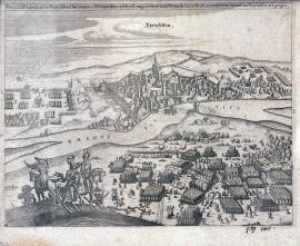
Rheinfelden, On
18.02.1638 (do 03.03.1638)This engraving is much alike the record No 227/29 D, pg. 185. However in the foreground is depicted the battle itself instead of the army formations and camps that are on the above-stated record. It can be presumed that both prints are either the work by one person, or that the print from the year 1634 was used as a model for the depiction of the fight of Rheinfelden in 1638.
Signature: Not available
Autor: Unknown
Original name: Hartes Treffen zwischen den Keiserischen, Chur. Beyer. und Wimarischen völkern Sontags den 28. / 18. wie auch Mittwichs den 21. diss und 3. Marty Ao. 1638 bey und umb Rheinfelden vorgangen.
Katalogová čísla: Collection Český Šternberk, kód: 252/30 D
After the long and difficult negotiations with the French Chancellor Richelieu ended without any result, the Duke of Saxon-Weimar marched his army towards the Rhine and besieged the town of Reinfelden on 16 January 1638. The cannonade started to bombard the town on 28 January and the imminent and final attack was planned for 19 February. Unexpectedly, however, the Imperial Generals Jan of Wehrt and Savelli with their regiments appeared outside the town, and commenced a fierce battle with the Swedish-French army. After some twists and turns in the powers the fight was won by the Imperial army. Bernhard of Weimar was forced to withdraw from the town and retreated hastily to Lauffenburg while the Imperial regiments marched into the town with a triumph. Nobody thought the fight could continue, when out of the blue, Bernhard of Weimar returned with his army on 3 March and immediately attacked the Imperial garrison, still intoxicated with the victory. The Swedish cavalry commanded by Tupadl penetrated the withdrawing Imperial army and captivated the generals Savelli, Wehrt, Enkefort and Speereuter. The victory of the Duke of Weimar was thus completed. Prince Rohan commanded the French regiments of the victorious army.
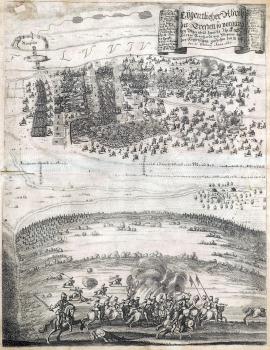
Rheinfelden, On
18.02.1638 (do 21.02.1638)The picture is divided into two parts across the middle. The wide stream of the Rhine with the town of Reinfelden on its other side flows at the top. Nearby a battle is raving, in which the Imperial army was finally defeated on 21 March 1638 thanks to the tactical art and ploy carried out by Bernhard of Weimar. The German explanatory text is placed on a wide unrolled ribbon banner at the top right and together with the caption 1-11 and A-N. The bottom half of the picture depicts the first battle on 18 February, which was won by the Imperial army.
Signature: Not available
Autor: Unknown
Original name: Eygentlicher Abrisz der Treffen so vorgangen bey Rheinfeld zwischen Ihr Fürstl. Gnaden Herzog Bernhard von Weymar und den Keyserischen geschehen 18. /28. bis 21. February Anno 1638.
Katalogová čísla: Collection Český Šternberk, kód: 253/292
After the long and difficult negotiations with the French Chancellor Richelieu ended without any result, the Duke of Saxon-Weimar marched his army towards the Rhine and besieged the town of Reinfelden on 16 January 1638. The cannonade started to bombard the town on 28 January and the imminent and final attack was planned for 19 February. Unexpectedly, however, the Imperial Generals Jan of Wehrt and Savelli with their regiments appeared outside the town, and commenced a fierce battle with the Swedish-French army. After some twists and turns in the powers the fight was won by the Imperial army. Bernhard of Weimar was forced to withdraw from the town and retreated hastily to Lauffenburg while the Imperial regiments marched into the town with a triumph. Nobody thought the fight could continue, when out of the blue, Bernhard of Weimar returned with his army on 3 March and immediately attacked the Imperial garrison, still intoxicated with the victory. The Swedish cavalry commanded by Tupadl penetrated the withdrawing Imperial army and captivated the generals Savelli, Wehrt, Enkefort and Speereuter. The victory of the Duke of Weimar was thus completed. Prince Rohan commanded the French regiments of the victorious army.
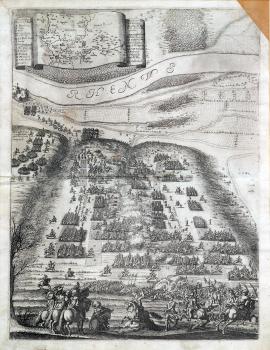
Rheinfelden, On
18.02.1638 (do 21.02.1638)The usual explanatory inscription is missing on this copper engraving. However, according to the depicted event and the topographical and factual caption, this is undoubtedly the Battle of Rheinfelden, on 18 – 12 February 1638. This tall picture is divided by the river Rhine across the middle. A battle is raving near the river; there are three buglers and a group of Croatians at the foreground. There is a map of the Upper Rhineland on the wide unrolled ribbon banner at the top. The captions A-O and a-i are on both sides.
Signature: Not available
Autor: Unknown
Original name:
Katalogová čísla: Collection Český Šternberk, kód: 254/455
After the long and difficult negotiations with the French Chancellor Richelieu ended without any result, the Duke of Saxon-Weimar marched his army towards the Rhine and besieged the town of Reinfelden on 16 January 1638. The cannonade started to bombard the town on 28 January and the imminent and final attack was planned for 19 February. Unexpectedly, however, the Imperial Generals Jan of Wehrt and Savelli with their regiments appeared outside the town, and commenced a fierce battle with the Swedish-French army. After some twists and turns in the powers the fight was won by the Imperial army. Bernhard of Weimar was forced to withdraw from the town and retreated hastily to Lauffenburg while the Imperial regiments marched into the town with a triumph. Nobody thought the fight could continue, when out of the blue, Bernhard of Weimar returned with his army on 3 March and immediately attacked the Imperial garrison, still intoxicated with the victory. The Swedish cavalry commanded by Tupadl penetrated the withdrawing Imperial army and captivated the generals Savelli, Wehrt, Enkefort and Speereuter. The victory of the Duke of Weimar was thus completed. Prince Rohan commanded the French regiments of the victorious army.
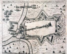
Meppen, On
11.05.1638The fortified town of Meppen is in the centre of the engraving, however represented only by a large church. Four lines of army troops are marching into the centre of the town. Cannon batteries are firing in two places. The confluence of the rivers Ems and Hase is near the town; soldiers are wading the water. Individual cavalry and infantry soldiers are attacking the town. There are large trees in the countryside.
Signature: Not available
Autor: Unknown
Original name: Statt und Vestung Meppen von den Keyserischen durch einen Anschlag erobert, welches geschehen den 1. / 11. Mey Anno 1638.
Katalogová čísla: Collection Český Šternberk, kód: 255/39 D
Some fights and smaller clashes between the two armies took place on the side battlefields after the Battle of Rheinfelden in March 1638, in which Duke of Weimar defeated the Imperial army and captivated the Generals Savelli, Werth, Enkefort and Speereuter. The Imperial regiments attacked unexpectedly Meppen on Ems in Hannover conquering the town on 11 May 1638.
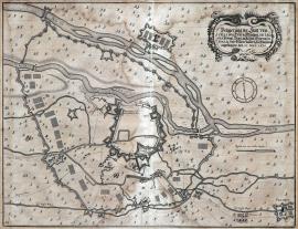
Vercelli, On
27.05.1638The picture of Milano and its surrounding is done to resemble a map. The landscape is dotted with trees, the rivers Sesia and Seruio flow across the picture. The small town of Pelarol is at the bottom right. It is surrounded by army constructions and camps. There is an ornamental cartouche in the right top corner with the stated German text. An orienteering compass is drawn below it.
Signature: Not available
Autor: Unknown
Original name: Belägerung der Statt Vercelli von Herrn Margra. de Leganes Königl. May. zu Hispa. General in Italia und Gubernatoren in Mayland angefangen den 27. May 1638.
Katalogová čísla: Collection Český Šternberk, kód: 256/290
Charles V implanted the Sforza family to Milano in 1515, however when Maximilian Sforza died childless in 1535, his position was taken by Fillip II, which was the start of a cruel war between the Spanish governors. The Spanish Margrave de Leganes besieged the fortress of Vercelli, situated west of Milano, in the direction of Turin in 1638. The fortress was occupied by the French, who had been fighting the Spanish for many years.
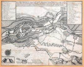
Breisach, On
06.08.1638 (do 07.12.1638)This map shows the river Rhine which streams out into many branches near Brysach. The town and the fortress are painted on the left bank of the river. There are various strongholds, fortifications, military camps etc. in the surrounding countryside. Banners with the topographical and factual caption A-Z and 1-16 are at the top left and right. A profile of the fortification system is shown on a special banner. Above it is an orienteering compass. The German explanatory text, cited word-for-word above is placed above the picture. According to Drugulin, the picture is the work by Th. Kluge, an artillery colonel.
Signature: M. Merian exc.
Autor: Merian Mateus, mědirytec a nakladatel ve Frankfurtu nad Mohanem
Original name: Eigentliche Abbildung des Hauptpasses und der fürtrefflichen Vestung Brysach, wie dieselbe von Ihr. fürstl. Gnaden Hertzogen Bernhartem zu Sachsen mit Schantzen und Retranchements gefasst, auch wie von dem 6. Augusti bisz auf den 2. Decembris Anno 1638 mainteniert und zu entlicher übergab bezwungen worden.
Katalogová čísla: Collection Český Šternberk, kód: 259/279
The Imperial fortress of Brysach, situated on the upper stream of the Rhine near the strategically important pass not far from the Swiss borders, was in danger after the defeat of the Imperial forces at Wittenweyer on 30 July 1638 and the resultant superiority of the Swedish-French army. Battles between the Swedish-French army commanded by the Duke of Weimar and the French General Longuevill and the Imperial regiments under Götz and Charles of Lorraine were fought here throughout the entire year 1638. The fortress was commanded by the Imperial General Reinach. Götz tried his best to prevent Brysach from being defeated by the Swedish, operating skilfully in the difficult mountainous terrain and calling Charles of Lorraine situated in Alsace to help. In the end, Bernhard of Weimar tightened the grip on the town surrounding it closely. All attempts of the Imperial forces to liberate the fortress from the blockade failed. Soon enough the garrison as well as the citizens of the town suffered unbearable starvation, which forced them eating rats – even dead horses and human bodies. Three times did the commander of fortress Reinach refuse to give the town up to the Swedish. Nevertheless, on 7 December, the resistance of defendants, half-starved to death, broke down and the town capitulated. Bernhard Saxon-Weimar’s capitulation conditions were fair and generous, reflecting his admiration of the unusual bravery of the defendants.
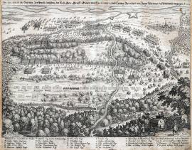
Wittenweier, On
09.08.1638The river Rhine flows at the top border of the engraving. The small village of Wittenweyer is below right. A visible path goes down the middle of the picture; it turns into a dam further down. There is a thick forest in the foreground with the Swedish horse-pulled carriages and several infantry soldiers. The battle is depicted in the centre of the engraving – the Imperial army is already retreating. The topographical and factual legend A-S and 1-15 is at the bottom.
Signature: Not available
Autor: Unknown
Original name: Delineation des hartten Treffens so zwischen den Key. Gen. Graff Götzen duc de Savelli und Herzog Bernhard von Saxen Weinmar bey Wittenweyer vorgangen. A. 1638.
Katalogová čísla: Collection Český Šternberk, kód: 258/197
Last years of his career as a military commander Duke Bernhard Saxon-Weimar devoted to fighting with his French allies against the Imperial-Bavarian troops, mostly in Rhineland, which was closest for the French. Most of his fights were victorious at that time. On 30 July 1638 at high noon Bernhard of Weimar sat out with his army from a forest (depicted at the bottom of the engraving) and saw the Imperial army in front of him positioned between Wittenweyer and Kappela with the river Rhine behind them. Commanding the centre of the Swedish-French army, Duke immediately noticed the disadvantaged position of the Imperial army and ordered attack. General Tupadel commanded the right wing of the Swedish army and the Count of Nassau the left one. A battle broke out and soon enough, the right wing of the Imperial army commanded by Savelli was shattered under the attacks of Tupadel’s cavalry. However, Götz managed to straighten up the situation with his cavalry. As the battle remained indecisive for a long time, Bernhard used a plot. He sent a large group of drummers and buglers to a nearby forest on the left flank of the Imperial army ordering them to make huge noise with trumpets and drums to evoke the idea that the Imperial regiments were caught off-guard. The trick did not fail. The Imperial army started retreating pillaging their own supplies on the way. The result of the battle was a shattering defeat of the Imperial army, which lost 11 cannons, 2 mortars, 82 battle banners and standards, 3000 carriages with various supplies. 1500 soldiers died at the battlefield and 1300 were taken prisoners. The winners lost only 600 men, however General Tupadel was captured by the Imperial army.
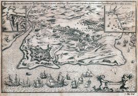
On
07.09.1638The engraving depicts the peninsula cutting into the Biscay Bay with the fortress of Fuenterrabia. The fight between the Spanish and the French armies can be seen behind the town. A French fleet is on the see in the foreground. There are two winged mermaids depicted on the sea. They are holding a shield with the inscription: ‚Fuenterrabia‘. A rectangle showing the geographical situation of the city and the fortress situated between Biaritz and San Sebastian at the foothills of the Pyrenees, is in the right corner. A detail of fortification is at the top left.
Signature: Not available
Autor: Unknown
Original name: Geometrische Delineation der Belägerung Fuentarabiae wieselbige Statt am 6. und 7. Septembris von den Spanischen glücklich entsetzt worden. Anno 1638.
Katalogová čísla: Collection Český Šternberk, kód: 257/165
The war between Spain and France, which started on 1630 over the succession in Italian Mantua, reached a crisis on the part of France in 1638. The Cardinal Infante Ferdinand successfully resisted the attacks of the Dutch in the Netherlands and three French armies. He even ousted them out of his country. The military campaign led by Richelieu with rather large army against the Spanish borders ended even worse. The French never managed to conquer the small poorly protected fortress of Fuenterrabia, situated directly on the borders of the two countries. The ad-hoc called Spanish militia scattered the French regiments in one attack chasing them to flee miserably. This fight took place on 7 September 1638.
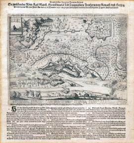
Breisach, On
07.12.1638The print depicts the siege of Brysach with the river Rhine spanned by two bridges flowing below. There are many trees in the landscape. Three buglers are in the left foreground. A cross-section of the fortification is placed in a special banner at the top left. The caption A-N and the above-stated German text are below the picture. There is also a long text divided into fourteen articles, including the conditions of capitulation and handover of the town by the General Reinach to the Duke Bernhard Saxon-Weimar.
Signature: Not available
Autor: Unknown
Original name: Eigentlicher Abrisz der Belägerung des vesten Pas Braisachs und sampt dem Auszug, welcher ist geschehen den 9. 19. Decembris 1638 Jahrs.
Katalogová čísla: Collection Český Šternberk, kód: 260/333
The Imperial fortress of Brysach, situated on the upper stream of the Rhine near the strategically important pass not far from the Swiss borders, was in danger after the defeat of the Imperial forces at Wittenweyer on 30 July 1638 and the resultant superiority of the Swedish-French army. Battles between the Swedish-French army commanded by the Duke of Weimar and the French General Longuevill and the Imperial regiments under Götz and Charles of Lorraine were fought here throughout the entire year 1638. The fortress was commanded by the Imperial General Reinach. Götz tried his best to prevent Brysach from being defeated by the Swedish, operating skilfully in the difficult mountainous terrain and calling Charles of Lorraine situated in Alsace to help. In the end, Bernhard of Weimar tightened the grip on the town surrounding it closely. All attempts of the Imperial forces to liberate the fortress from the blockade failed. Soon enough the garrison as well as the citizens of the town suffered unbearable starvation, which forced them eating rats – even dead horses and human bodies. Three times did the commander of fortress Reinach refuse to give the town up to the Swedish. Nevertheless, on 7 December, the resistance of defendants, half-starved to death, broke down and the town capitulated. Bernhard Saxon-Weimar’s capitulation conditions were fair and generous, reflecting his admiration of the unusual bravery of the defendants.
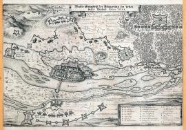
Breisach, On
07.12.1638This is a plan of the area around Brysach. The river Rhine with several islands flows through the landscape. The town itself with the fortress is done in a very charming way and with great precision. Enemy’s army formations and fortifications are in the surroundings. A large forest with the formation of the General Götz’s army is at the top right. An oblong banner with the caption A-T is at the bottom right.
Signature: Not available
Autor: Unknown
Original name: Wahrer Grundrisz der Belägerung des vesten Passes Brysach. Anno 1638.
Katalogová čísla: Collection Český Šternberk, kód: 267/395
The Imperial fortress of Brysach, situated on the upper stream of the Rhine near the strategically important pass not far from the Swiss borders, was in danger after the defeat of the Imperial forces at Wittenweyer on 30 July 1638 and the resultant superiority of the Swedish-French army. Battles between the Swedish-French army commanded by the Duke of Weimar and the French General Longuevill and the Imperial regiments under Götz and Charles of Lorraine were fought here throughout the entire year 1638. The fortress was commanded by the Imperial General Reinach. Götz tried his best to prevent Brysach from being defeated by the Swedish, operating skilfully in the difficult mountainous terrain and calling Charles of Lorraine situated in Alsace to help. In the end, Bernhard of Weimar tightened the grip on the town surrounding it closely. All attempts of the Imperial forces to liberate the fortress from the blockade failed. Soon enough the garrison as well as the citizens of the town suffered unbearable starvation, which forced them eating rats – even dead horses and human bodies. Three times did the commander of fortress Reinach refuse to give the town up to the Swedish. Nevertheless, on 7 December, the resistance of defendants, half-starved to death, broke down and the town capitulated. Bernhard Saxon-Weimar’s capitulation conditions were fair and generous, reflecting his admiration of the unusual bravery of the defendants.
Würzburg, On
01.01.1639 (do 31.12.1639)This engraving depicts a map of the territory along the river Maiz, mostly the regions situated northward and southward of the river. ‚Pipinus rex Galliae, fundator ecclesiae Herbip’,,Carolus Magnus imp. Pipini regis Galliorum filius’and,Gosbertus dux’ (?.).‘ are depicted in the top left corner. There are several coats-of-arms at the top right. The coat-of-arms of the contemporary Bishop of Bamberg-Würzburg and the coat-of-arms of Duke Franz of the East Franconia. Nearby are two figures representing St Killian and St. Burkhard; undoubtedly the patrons of the region. Signatures of the engravers are in an ornamental cartouche at the bottom right (as stated on the previous sheet).
Signature: Durch Hans Georgen und Georg Conrad die Jungen zu Rottenburg ob der Tauber 1639.
Autor: Jungen Georg Conrad, mědirytec v Rotenburgu n/T.
Original name: Nova Delineatio Episcopat. Ducatus Herbip. cum locis adiacentibus.
Katalogová čísla: Collection Český Šternberk, kód: 273/214
Following the victory of Breitenfeld in 1631, the Swedish occupied the entire area along the river Maiz and Gustav Adolph forced out the Bishops of Bamberg and Würzburg. The Swedish king created a new Franconia Duchy from the two bishoprics, which Chancellor Oxenstierna gave to Bernhard Saxon-Weimar for his merits in Swedish victories in 1633. However, the war luck is unsteady and this situation soon turned. The Swedish were defeated in Nördlingen by the Imperial army and the stated territories were reoccupied by the Catholics, who immediately reinstated the two bishoprics.
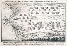
Thionville, On
01.01.1639Signature: Not available
Autor: Unknown
Original name:
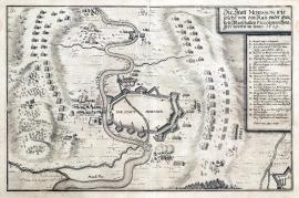
Mousson, On
01.06.1639 (do 30.06.1639)The town of Mousson is schematically sketched in the middle of the picture; the river Meuse flows nearby. Military formations are built on both sides of the town. The stated German text is in a square banner at the top right; the caption A-R is lower down in another banner.
Signature: Carlo Cappi ing. delineavit.
Autor: Cappl Carlo, fortifikační inženýr a kreslíř plánů
Original name: Die Statt Mousson wie solche von den Kay. under general-Veltmarschallen Piccolomini belagert worden im Junio 1639.
Katalogová čísla: Collection Český Šternberk, kód: 271/373
The General Piccolomini commanded the Imperial-Spanish army operating on the French borders. Among others he besieged the town of Mousson in Alsace near Metz. Soon after this event, Piccolomini was hastily recalled to the inherited Austrian lands, where the Swedish army commanded by Banner was seriously pushing the Imperial forces and pillaging mainly the lands of the Czech Kingdom.
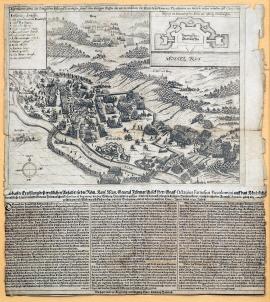
Thionville, On
04.06.1639The stream of the river Moselle is in the left third of the picture. A battle is raving on its banks, there is a forested hilly landscape in the background. A schematic sketch of the fortress is in the top right corner with the caption 1-13 on the left. There is an extensive three-columned German text below the picture part of the print. It describes in detail the progress of the depicted battle.
Signature: Nachgedruckt zu Augspurg in Verlegung Marx Antony Hannas
Autor: Hannas Marx Anthon, rytec a nakladatel v Augsburgu
Original name: Eigentlicher Abrisz der königlichen Festung Diedenhofen sammt dem blutigen Treffen darvor in welchem ihr. Excelenz Herr General Piccolomini eine herrliche viktori erhalten, den 4. Juni 1639.
Katalogová čísla: Collection Český Šternberk, kód: 269/420
The French army suffered several defeats in the long war with Spain during the last years of the forth decade of the 17th century. A bloody battle broke out between the two enemies on 4 June 1639 near the town of Diedenhofen (Tionville), situated approx. 30 km south of Luxembourg. While the French forces were besieging the town and the fortress, the General Count Piccolomini arrived with his army, liberated the suffering town and crushed the French commanded by the General de Fauquiéres. The entire French infantry was killed, wounded or captured. At this time, General Piccolomini fought on the side of the Spanish Kingdom.
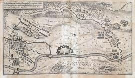
Thionville, On
04.06.1639The Moselle river is drawn parallel to the bottom edge of the engraving. The town of Diedenhofen is only schematically sketched along the river. A wide strip of the French fortifications circles the town. A battle with the Imperial-Spanish army under Piccolomini is just commencing in the space between the fortifications and the fortress. The above-stated text is in a square on the left. The author of the print, fortification engineer Carlo Cappi, put the main emphasis on the precise drawing of various fortification constructions.
Signature: Carlo Cappi ing. Delineavit.
Autor: Cappl Carlo, fortifikační inženýr a kreslíř plánů
Original name: Belagerung der Vöstung Diedenhofen und wie solche von der Kays. Armée unter dem Commando Ihr. Excel. General Piccolomini entsetzt und die Franzosen darvor weg geschlagen worden, im Juni 1639.
Katalogová čísla: Collection Český Šternberk, kód: 270/4221
The French army suffered several defeats in the long war with Spain during the last years of the forth decade of the 17th century. A bloody battle broke out between the two enemies on 4 June 1639 near the town of Diedenhofen (Tionville), situated approx. 30 km south of Luxembourg. While the French forces were besieging the town and the fortress, the General Count Piccolomini arrived with his army, liberated the suffering town and crushed the French commanded by the General de Fauquiéres. The entire French infantry was killed, wounded or captured. At this time, General Piccolomini fought on the side of the Spanish Kingdom.
Duyne, On
21.10.1639This is a wide picture of a great naval battle. The coast of England is visible on the horizon in the far background. The surface of the see virtually swarms with various battle ships; a burning ship surrounded by safe boats is in the right foreground. The German explanatory text is placed above the picture, the caption A-S is below it.
Signature: Not available
Autor: Unknown
Original name: Wahre Abbildung der mächtigen Seeschlacht so sich zwischen den Hispanischen und Holländischen Schiffsarmata in den Duynen den 21. Octobris 1639 zugetragen, darinnen die Höllander under dem Admiral Martin Harperstromp die victori erhalten.
Katalogová čísla: Collection Český Šternberk, kód: 272/400
The war between Spain and the Netherlands lasted many years, there was a twelve-year ceasefire from 9 April 1609 till the year 1621 but after its end, new fights broke out bringing many important victories to the Dutch, mainly after the Duke Frederick Henry of Orange I took over the political and military issues of the state. The depicted naval battle near Duyne fought in the Straits of Dover on 21 October 1639, shows yet another defeat of the Spanish fleet.
Turín, On
01.01.1640 (do 31.12.1640)The print depicts a detailed plan of the territory around Turin with the river Po spanned by two bridges. A hilly countryside with the Moncaglieri castle is in the foreground. A wide strip of Spanish trenches circles the town; military formations are lined-up in various places in the surroundings. There is a short descriptive German text is on an unrolled ribbon banner.
Signature: Not available
Autor: Unknown
Original name: Belagerung der Statt und Citadell Turino im Jahrw 1640.
Katalogová čísla: Collection Český Šternberk, kód: 289/401
The French army finally started winning above the Medieval powerful Spain around 1640 after the long war between France and Spain. The French forces won in the Spanish Netherlands, the French banners were flying on Iberian Peninsula, and the situation was not good for the Spanish army in Italy either. They were still trying to seize Turin and its citadel, however without any success. This meant a great loss of the Spanish strong positions in Italy.
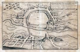
Kolín, On
01.02.1640 (do 28.02.1640)The print shows a ground-plan of Cologne with its suburbs. The city centre is only sketched. At the bottom flows the river Elbe spanned by a bridge, which connects the city to its quarter Zálabí, with a quadrant medieval tower, the so-called Prachárna (Gunpowder) Tower. The Imperial army is moving closer to the city. The above-stated text is on an unrolled ribbon banner above the picture. There is also the caption A-L.
Signature: Carlo Cappi ingenieur delineavit.
Autor: Cappl Carlo, fortifikační inženýr a kreslíř plánů
Original name: Grundrisz der Statt Kolin, und wie solche von der Kays. Armada mit Gewalt erobert worden im Monat Februario 1640.
Katalogová čísla: Collection Český Šternberk, kód: 274/368
Following his victory over the Saxons commanded by General Marazini on 20 May 1639, the Swedish General Baner marched with his army to Bohemia. Matthias Gallas could no longer prevent it for his army was devastated. The Swedish forces ravaged the Czech territories mercilessly, plundering the countryside, burning villages and entire towns. This Swedish outrageous pillaging in Bohemia became proverbial and lasted until year 1640, when the Imperial movement built a new army under the command of the Archduke Leopold Wilhelm, a brother of the Emperor Ferdinand III, and the General Count Piccolomini. The Swedish occupied the entire Central and Northwest Bohemia, however Prague never subdued to Baner. The new Imperial army forced the Swedish army to withdraw hastily from Bohemia. During this campaign, the Imperial Army liberated the following Czech towns: Kolín, Hradec Králové (20 February), Chlumec nad Cidlinou (February), Brandýs nad Labem (March) a Litoměřice (March). The Swedish retreated to the Western Saxony pursued by the Imperial army. The depicted events took place in 1640.
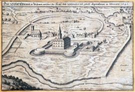
Chlumec, On
01.02.1640 (do 28.02.1640)The heavily fortified Chlumec Chateau is depicted in the centre of the engraving. (It is the original old chateau not the present-day ‚Karlova Koruna Chateau‘.) Nearby is a small church and there is a large lake on the other side of the chateau (possibly the so-called Žehuňský Lake). The above-stated text is above the picture.
Signature: Carlo Cappi ingen. deel.
Autor: Cappl Carlo, fortifikační inženýr a kreslíř plánů
Original name: Das Schloss Chlumnitz in Böhmen, welches die Kays. den Schweden mit Gewalt abgenohmen im Februario 1640.
Katalogová čísla: Collection Český Šternberk, kód: 276/467
Following his victory over the Saxons commanded by General Marazini on 20 May 1639, the Swedish General Baner marched with his army to Bohemia. Matthias Gallas could no longer prevent it for his army was devastated. The Swedish forces ravaged the Czech territories mercilessly, plundering the countryside, burning villages and entire towns. This Swedish outrageous pillaging in Bohemia became proverbial and lasted until year 1640, when the Imperial movement built a new army under the command of the Archduke Leopold Wilhelm, a brother of the Emperor Ferdinand III, and the General Count Piccolomini. The Swedish occupied the entire Central and Northwest Bohemia, however Prague never subdued to Baner. The new Imperial army forced the Swedish army to withdraw hastily from Bohemia. During this campaign, the Imperial Army liberated the following Czech towns: Kolín, Hradec Králové (20 February), Chlumec nad Cidlinou (February), Brandýs nad Labem (March) a Litoměřice (March). The Swedish retreated to the Western Saxony pursued by the Imperial army. The depicted events took place in 1640.
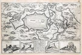
Hradec Králové, On
20.02.1640The engraving maps out the situation of the fortress with an extensive system of water canals. Few villages situated around the town are burning. There is an orienteering compass at the top. Special squares show the following: 2 details of fortification constructions, details of the St Anthony and St Peter’s Gate. The above-stated text is in the centre of the picture.
Signature: Carlo Cappi ingenieur delineavit.
Autor: Cappl Carlo, fortifikační inženýr a kreslíř plánů
Original name: Wahrer Grundrisz der Statt Königgrätz in Böhmen sampt den Schwed. Fortificationen und wie solche von der röm. kays. May. Armada mit Gewalt eingenohmen worden, den 20. Februari 1640.
Katalogová čísla: Collection Český Šternberk, kód: 275/381
Following his victory over the Saxons commanded by General Marazini on 20 May 1639, the Swedish General Baner marched with his army to Bohemia. Matthias Gallas could no longer prevent it for his army was devastated. The Swedish forces ravaged the Czech territories mercilessly, plundering the countryside, burning villages and entire towns. This Swedish outrageous pillaging in Bohemia became proverbial and lasted until year 1640, when the Imperial movement built a new army under the command of the Archduke Leopold Wilhelm, a brother of the Emperor Ferdinand III, and the General Count Piccolomini. The Swedish occupied the entire Central and Northwest Bohemia, however Prague never subdued to Baner. The new Imperial army forced the Swedish army to withdraw hastily from Bohemia. During this campaign, the Imperial Army liberated the following Czech towns: Kolín, Hradec Králové (20 February), Chlumec nad Cidlinou (February), Brandýs nad Labem (March) a Litoměřice (March). The Swedish retreated to the Western Saxony pursued by the Imperial army. The depicted events took place in 1640.
Brandýs, On
01.03.1640 (do 31.03.1640)The Brandýs Chateau is situated near the river Elbe spanned by a bridge. A stylish maintained garden is depicted around the chateau. The ruins of the town of Staré Boleslav, fortification constructions and the river Jizera are in the foreground. A cross-section of a fortification construction is placed in the small square banner at the far left of the print. The caption A-E is lower down. The inscription stated word-for-word on the previous page is on an unrolled ribbon banner above the picture.
Signature: Carlo Cappi ingenieur delineavit.
Autor: Cappl Carlo, fortifikační inženýr a kreslíř plánů
Original name: Das Schloss Brandeysz in Böhmen und verschantzungen des schwedischen Velds welches general Baner vor den Kayserischen verlassen im Martio 1640.
Katalogová čísla: Collection Český Šternberk, kód: 277/348
Following his victory over the Saxons commanded by General Marazini on 20 May 1639, the Swedish General Baner marched with his army to Bohemia. Matthias Gallas could no longer prevent it for his army was devastated. The Swedish forces ravaged the Czech territories mercilessly, plundering the countryside, burning villages and entire towns. This Swedish outrageous pillaging in Bohemia became proverbial and lasted until year 1640, when the Imperial movement built a new army under the command of the Archduke Leopold Wilhelm, a brother of the Emperor Ferdinand III, and the General Count Piccolomini. The Swedish occupied the entire Central and Northwest Bohemia, however Prague never subdued to Baner. The new Imperial army forced the Swedish army to withdraw hastily from Bohemia. During this campaign, the Imperial Army liberated the following Czech towns: Kolín, Hradec Králové (20 February), Chlumec nad Cidlinou (February), Brandýs nad Labem (March) a Litoměřice (March). The Swedish retreated to the Western Saxony pursued by the Imperial army. The depicted events took place in 1640.
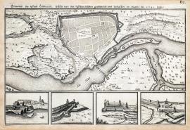
Litoměřice, On
01.03.1640 (do 31.03.1640)This copper engraving is divided into two parts; a schematically sketched plan of Litoměřice with fortifications is at the top, while the river Elbe is at the bottom. There are four details of various parts of the town and technical cross-sections of fortification constructions in the other part of the picture.
Signature: Not available
Autor: Unknown
Original name: Grundrisz der Statt Leutmaritz, welche von den Schwedischen geplündert und verlassen, im Martio des 1640 Jahrs.
Katalogová čísla: Collection Český Šternberk, kód: 278/351
Following his victory over the Saxons commanded by General Marazini on 20 May 1639, the Swedish General Baner marched with his army to Bohemia. Matthias Gallas could no longer prevent it for his army was devastated. The Swedish forces ravaged the Czech territories mercilessly, plundering the countryside, burning villages and entire towns. This Swedish outrageous pillaging in Bohemia became proverbial and lasted until year 1640, when the Imperial movement built a new army under the command of the Archduke Leopold Wilhelm, a brother of the Emperor Ferdinand III, and the General Count Piccolomini. The Swedish occupied the entire Central and Northwest Bohemia, however Prague never subdued to Baner. The new Imperial army forced the Swedish army to withdraw hastily from Bohemia. During this campaign, the Imperial Army liberated the following Czech towns: Kolín, Hradec Králové (20 February), Chlumec nad Cidlinou (February), Brandýs nad Labem (March) a Litoměřice (March). The Swedish retreated to the Western Saxony pursued by the Imperial army. The depicted events took place in 1640.
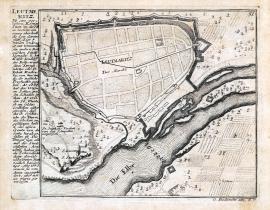
Litoměřice, On
01.03.1640 (do 31.03.1640)This is a small schematically sketched plan of the town of Litoměřice with its nearest surroundings. The river Elbe flows on the right. There is an extensive German text describing the town in the way of a chronicle on the left side.
Signature: G. Bodenehr excudit.
Autor: Bodenehr G., mědirytec a kartograf
Original name: Leutmeritz
Katalogová čísla: Collection Český Šternberk, kód: 279/412
Following his victory over the Saxons commanded by General Marazini on 20 May 1639, the Swedish General Baner marched with his army to Bohemia. Matthias Gallas could no longer prevent it for his army was devastated. The Swedish forces ravaged the Czech territories mercilessly, plundering the countryside, burning villages and entire towns. This Swedish outrageous pillaging in Bohemia became proverbial and lasted until year 1640, when the Imperial movement built a new army under the command of the Archduke Leopold Wilhelm, a brother of the Emperor Ferdinand III, and the General Count Piccolomini. The Swedish occupied the entire Central and Northwest Bohemia, however Prague never subdued to Baner. The new Imperial army forced the Swedish army to withdraw hastily from Bohemia. During this campaign, the Imperial Army liberated the following Czech towns: Kolín, Hradec Králové (20 February), Chlumec nad Cidlinou (February), Brandýs nad Labem (March) a Litoměřice (March). The Swedish retreated to the Western Saxony pursued by the Imperial army. The depicted events took place in 1640.
Plauen, On
01.04.1640 (do 30.04.1640)The print depicts the panorama of the landscape around the town of Plauen in the West Saxony; the river Elster flows through here. Plauen is depicted on the right side of the picture, but its centre is only schematically sketched. A various phases of the fights between the Swedish and the Imperial cavalry led by von Bredau are shown in the terrain around the town. The German explanatory text is placed below the picture; the caption A-H is placed in an ornamental rectangular banner.
Signature: Not available
Autor: Unknown
Original name: Geschehenes Treffen zwischen dem von Bredau und den Schwedischen bey Plawen, im April Anno 1640. Dimicatio Plavenam.
Katalogová čísla: Collection Český Šternberk, kód: 280/371
The Imperial army led by the Archduke Leopold Wilhelm forced the Swedish commanded by General Baner to withdraw from Bohemia hastily in the first half of 1640. The Swedish army was pursued by the Imperial forces and marched through the West Saxony to Hesse, where it was stopped by the regiments of the General Piccolomini. Some small battles were fought between the Imperial and the Swedish forces during the march through Saxony. One of them took place near Plauen in April.
Saalfeld, On
01.05.1640 (do 31.05.1640)The picture outlines the position of two strong armies near Saalfeld, which lies on the right side of the print above the river Saale flowing across the entire length of the picture. The regular formation of the Swedish-French regiments is at the bottom, while the Imperial Army is fortified at the top. The landscape is very meticulously drawn with the attention to detail, there are many minor scenes: for instance a burning village, military guards etc. There is an ornamental cartouche with the German text from the previous sheet at the top right. The caption A-E and F-K is at the bottom left and right.
Signature: Not available
Autor: Unknown
Original name: Abbildung der zwey mächtigen Veldtläger der Röm. Kays. May. an einem und der conföderierten Cronen und Ständen Arméen anders teils sampt der Gelegenheit selbiger Gegend bey Saalfeldt und wie weit eine der anderen weichen müssen. Im Mayo 1640.
Katalogová čísla: Collection Český Šternberk, kód: 281/456
During the year 1639 Baner stayed with his army in Bohemia pillaging and plundering the land mercilessly. However, the Imperial forces built a new army commanded by the Archduke Leopold Wilhelm, a brother of Ferdinand III, and the Field Marshal Count Piccolomini. The Swedish were forced to withdraw from Bohemia and pursued by the Imperial forces marched through the West Saxony to Thuringia. The Imperial generals hoped to finally defeat the Swedish with their bigger army. Nevertheless, the Swedish joined with the Hesse, French and Brunswick regiments and thus fortified, Banner tried to provoke a battle and take an advantage of his present superiority. However, Piccolomini assumed an advantageous strong position near Saalfeld, which the Swedish could not attack without serious losses. Thus, both large armies stood against each other inactively for some time. Both camps were suffering from the lack of food. Baner retreated first, and as the Bavarian General Mercy with his army spoiled his intention to march to Franconia, he went to Hesse, while Piccolomini took a position near Fritzlar.
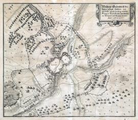
Arras, On
12.06.1640This print is made to resemble a map with the town and fortress Arras above Scarpa in its centre. The centre of the town is only schematically sketched, while the huge fortifications around the town are painted to detail. The French fortifications and trenches are built in a large circle around the town. The numerous various military regiments randomly pained in the near and far surroundings are noteworthy. There is a square ornamental vignette with the explanatory text at the top right. The map is engraved precisely and delicately, showing a skilled hand of an experienced and artistically mature engraver.
Signature: Not available
Autor: Unknown
Original name: Wahrer Grundrisz der vesten Statt Arras und wie solche durch Ludwig XIII. König in Frankreich und Nauarra belägert und erobert worden. Anno 1640.
Katalogová čísla: Collection Český Šternberk, kód: 282/306
Arras, currently in the Pas de Calais region, used to be the main town of the Artois and Burgundy areas. It experienced a difficult period of constantly changing governments, which ended at the turn of the 15th century. From that time the town belonged to the Austrian ruling house as part of the Spanish Netherlands. Fights over the city were common, but only French King Louis XIII managed to seized the town on 12 June 1640. France got a definite control over the city thanks to the Peace of 1659.
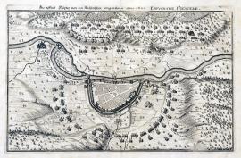
Höxter, On
01.07.1640 (do 31.12.1640)The Weser river flows across the picture. The town of Höxter is above it in the centre. Its centre is only schematically sketched. Military regiments are standing in a large curve below the town. There are more regiments atop the hills above the river, which are cannonading the area of the town. The image is very delicately done. The landscape is dotted with many big trees. A short explanatory inscription is placed above the picture.
Signature: Not available
Autor: Unknown
Original name: Die Statt Höxter von den Kayserlichen eingenommen Anno 1640.
Katalogová čísla: Collection Český Šternberk, kód: 287/479
The huge Imperial army under the command of the Archduke Leopold Wilhelm and the Marshal Piccolomini set out to Bohemia during the first months of 1640 to force out the Baner’s army, which was pillaging and plundering the land. Pursued by the Imperial army, the Swedish withdrew northwest, marching through the West Saxony and Thuringia to Hesse, where Baner joined with the Hessian, French and Brunswick regiments. For a short time both armies camped near Saalfeld, however no deciding battle was fought here as Piccolomini skilfully avoided fighting with the outnumbered enemy. Lack of food forced both armies to further strategic moves. First to go was the army of the Swedish, French, Hessian and Brunswick regiments commanded by Baner. The Imperial army followed soon after. Baner wanted to enter Franconia, but the Bavarian General Mercy stepped in his way. The Protestants therefore marched to the area between Wildungen and Zeigenhein in Hesse, while the Imperialists under Piccolomini encamped in Fritzlar on the river Eder. Both armies held these positions inactively until autumn 1640, when they started looking for a winter encampment. The Imperial army planned to stay in the Brunswick territory, but Baner spoilt this plan by marching to the Weser near Höxter. This forced the Imperialists to encamp in the allied lands, which was considered a strategic failure. The depicted episode happened near Fritzlar around 20 August 1640. It remains to add that soon after the Swedish seized Höxter on the Weser river, Baner marched with considerable forces to Bavaria to disturb the Imperial Diet session in Regensburg. Only a weak Swedish garrison was therefore left in Höxter, which was attacked and defeated by the imperial army without any bigger complications. The conquest of Höxter by the Imperial army that took place in the second half of 1640 is depicted on this copper engraving.
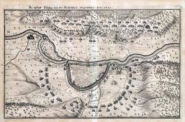
Höxter, On
01.07.1640 (do 31.12.1640)This print depicts the area along the Weser river with the fortified fortress of Höxter. The centre of the town is left unfinished. Several military troops are placed in the surroundings of the town, hilly and forested landscape scenery is in the background.
Signature: Carlo Cappi Ingen. delineavit.
Autor: Cappl Carlo, fortifikační inženýr a kreslíř plánů
Original name: Die Statt Höxter von den Kayserischen eingenohmen Anno 1640. Expugnatio Höxterae.
Katalogová čísla: Collection Český Šternberk, kód: 288/50 D
The huge Imperial army under the command of the Archduke Leopold Wilhelm and the Marshal Piccolomini set out to Bohemia during the first months of 1640 to force out the Baner’s army, which was pillaging and plundering the land. Pursued by the Imperial army, the Swedish withdrew northwest, marching through the West Saxony and Thuringia to Hesse, where Baner joined with the Hessian, French and Brunswick regiments. For a short time both armies camped near Saalfeld, however no deciding battle was fought here as Piccolomini skilfully avoided fighting with the outnumbered enemy. Lack of food forced both armies to further strategic moves. First to go was the army of the Swedish, French, Hessian and Brunswick regiments commanded by Baner. The Imperial army followed soon after. Baner wanted to enter Franconia, but the Bavarian General Mercy stepped in his way. The Protestants therefore marched to the area between Wildungen and Zeigenhein in Hesse, while the Imperialists under Piccolomini encamped in Fritzlar on the river Eder. Both armies held these positions inactively until autumn 1640, when they started looking for a winter encampment. The Imperial army planned to stay in the Brunswick territory, but Baner spoilt this plan by marching to the Weser near Höxter. This forced the Imperialists to encamp in the allied lands, which was considered a strategic failure. The depicted episode happened near Fritzlar around 20 August 1640. It remains to be added that soon after the Swedish seized Höxter on the Weser river, Baner marched with considerable forces to Bavaria to disturb the Imperial Diet session in Regensburg. Only a weak Swedish garrison was therefore left in Höxter, which was attacked and defeated by the imperial army without any bigger complications. The conquest of Höxter by the Imperial army that took place in the second half of 1640 is depicted on this copper engraving.
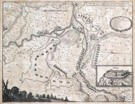
Neustadt, On
06.07.1640This is a detailed map of the area along the river Saale with the town of Neustadt, which is only schematically sketched. There are various fortification constructions and positions of military formations in the surroundings. The explanatory German text is at the top, the caption A-I is placed in a Lauer wreath. A ruin of Salzburg, situated opposite Neustadt near the Neuhaus Spa, is drawn in a separated square banner at the bottom right. Neustadt lies approx. 80 km northwest of Bamberg.
Signature: Not available
Autor: Unknown
Original name: Abrisz der Statt Neustadt in Franken sampt der Verschantzungen, worinnen die kayserl. und bayrisch. Arméen quartiert haben, den 6. Juli 1640.
Katalogová čísla: Collection Český Šternberk, kód: 283/385
During the year 1639 Baner stayed with his army in Bohemia pillaging and plundering the land mercilessly. However, the Imperial forces built a new army commanded by the Archduke Leopold Wilhelm, a brother of Ferdinand III, and the Field Marshal Count Piccolomini. The Swedish were forced to withdraw from Bohemia and pursued by the Imperial forces were marching through the West Saxony to Thuringia. The Imperial generals hoped to finally defeat the Swedish with their bigger army. Nevertheless, the Swedish joined with the Hesse, French and Brunswick regiments and thus fortified, Banner tried to provoke a battle and take an advantage of his present superiority. However, Piccolomini assumed an advantageous strong position near Saalfeld, which the Swedish could not attack without serious losses. Thus, both large armies stood against each other inactively for some time. Both camps were suffering from the lack of food. Baner retreated first, and as the Bavarian General Mercy with his army spoiled his intention to march to Franconia, he went to Hesse, while Piccolomini took a position near Fritzlar. It remains to add that Piccolomini’s Imperial army together with the Bavarian regiments commanded by Mercy encamped temporarily near the small town of Neustadt in Franconia during the period between they left the stable position near Saalfedt and encamped in Fritzlar. The described copper engraving depicts this event that took place on 6 July 1640.
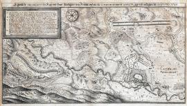
Fritzlar, On
20.08.1640It is a very delicately engraved plan of the town Fritzlar with extensive surroundings. As usually, the town itself is only schematically sketched. Since the engravers were mostly interested in depiction of the military topics, which they perceived as the purpose of their work, they intentionally neglected other topics, such as the landscape scenery, urban architecture etc. The river Eder flows across the engraving, with Fritzlar above it. At the top left is a banner with the caption A-V. Next to it is an orienteering compass. There are two long lines of army formations on the other side. The German explanatory text is above the picture image.
Signature: Not available
Autor: Unknown
Original name: Eigentliche Delineation des Kays. und Bayr. Veldläger bey Fritzlar und wie die confoederierte Armada gegen sie anzogen Augusto 1640.
Katalogová čísla: Collection Český Šternberk, kód: 284/377
The huge Imperial army under the command of the Archduke Leopold Wilhelm and the Marshal Piccolomini set out to Bohemia during the first months of 1640 to force out the Baner’s army, which was pillaging and plundering the land. Pursued by the Imperial army, the Swedish withdrew northwest, marching through the West Saxony and Thuringia to Hesse, where Baner joined with the Hessian, French and Brunswick regiments. For a short time both armies camped near Saalfeld, however no deciding battle was fought here as Piccolomini skilfully avoided fighting with the outnumbered enemy. Lack of food forced both armies to further strategic moves. First to go was the army of the Swedish, French, Hessian and Brunswick regiments commanded by Baner. The Imperial army followed soon after. Baner wanted to enter Franconia, but the Bavarian General Mercy stepped in his way. The Protestants therefore marched to the area between Wildungen and Zeigenhein in Hesse, while the Imperialists under Piccolomini encamped in Fritzlar on the river Eder. Both armies held these positions inactively until autumn 1640, when they started looking for a winter encampment. The Imperial army planned to stay in the Brunswick territory, but Baner spoilt this plan by marching to the Weser near Höxter. This forced the Imperialists to encamp in the allied lands, which was considered a strategic failure. The depicted episode happened near Fritzlar around 20 August 1640.
Řezno, On
15.09.1640The picture shows the session of the Imperial Diet in a large hall with coffered ceiling. Ferdinand III is on the throne surrounded by numerous court dignitaries. Each person is marked by a number, however the caption below the painting is unfortunately missing. The German text cited word-for-word is place above the picture part of the print.
Signature: Not available
Autor: Dümler Jeremias, nakladatel v Norimberku
Original name: Eigentlicher Abrisz der Reichstagsolenität so den 15. September 1640 Jahrs in Regenspurg bey Eröffnung 8 propositionen angestellt und gehalten worden.
Katalogová čísla: Collection Český Šternberk, kód: 285/442
The Emperor Ferdinand III called the Imperial Diet to Regensburg in autumn 1640. It was to discuss the end of the war and establishment of peace. The Emperor himself chaired the session, but despite being very benevolent, his peace proposals failed to succeed. The present ambassadors of electors and German counts caused problems to such extend that there was no positive outcome at all. The session was even interrupted by the Baner’s Swedish army, which suddenly appeared near Regensburg ready to besiege the city. However, the Emperor knew that the Swedish lacked proper technical equipment to besiege the city and continued therefore the session not allowing its participants to leave. Soon enough the Imperial army forced Baner to drop his intentions and withdraw northwards.
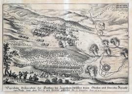
Ziegenhain, On
15.11.1640The print depicts a minor battle. Military formations are lined-up behind a forest, while the town of Ziegenhein is sketched on the right. Several cavalrymen are running away in the background, a bugler and three dragoons are depicted in the left foreground. A couple of villages with marked names in the surroundings are burning. The explanatory German text is below the picture.
Signature: Not available
Autor: Unknown
Original name: Eigentliche Delineation des Treffens bey Ziegenhein zwischen denen Obristen und Direktor Reinold von Rosa und dem Baron von Bredau den 15. Novembirs Anno 1640.
Katalogová čísla: Collection Český Šternberk, kód: 286/434
The huge Imperial army under the command of the Archduke Leopold Wilhelm and the Marshal Piccolomini set out to Bohemia during the first months of 1640 to force out the Baner’s army, which was pillaging and plundering the land. Pursued by the Imperial army, the Swedish withdrew northwest, marching through the West Saxony and Thuringia to Hesse, where Baner joined with the Hessian, French and Brunswick regiments. For a short time both armies camped near Saalfeld, however no deciding battle was fought here as Piccolomini skilfully avoided fighting with the outnumbered enemy. Lack of food forced both armies to further strategic moves. First to go was the army of the Swedish, French, Hessian and Brunswick regiments commanded by Baner. The Imperial army followed soon after. Baner wanted to enter Franconia, but the Bavarian General Mercy stepped in his way. The Protestants therefore marched to the area between Wildungen and Zeigenhein in Hesse, while the Imperialists under Piccolomini encamped in Fritzlar on the river Eder. Both armies held these positions inactively until autumn 1640, when they started looking for a winter encampment. The Imperial army planned to stay in the Brunswick territory, but Baner spoilt this plan by marching to the Weser near Höxter. This forced the Imperialists to encamp in the allied lands, which was considered a strategic failure. The depicted episode happened near Fritzlar around 20 August 1640. It remains to be added that the small fight between the cavalry, depicted on the described cooper engraving, took place on 15 November 1640 near Baner’s camp near Ziegenhein.
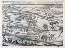
Ziegenhain, On
15.11.1640The print depicts a minor battle. Military formations are lined-up behind a forest, while the town of Ziegenhein is sketched on the right. Several cavalrymen are running away in the background, a bugler and three dragoons are depicted in the left foreground. A couple of villages with their names marked in the surroundings are burning. The explanatory German text is below the picture.
Signature: Not available
Autor: Unknown
Original name: Gründlicher Abrisz deren den 15. Novemb. 1640 zwischen Herrn Obr. Reinhold von Rosen mit dem Keys. General-Feld-Marschallen Leutnant Baron de Breda bay Ziegenhain gehabten Recontre.
Katalogová čísla: Collection Český Šternberk, kód: 286a/ 483 D
The huge Imperial army under the command of the Archduke Leopold Wilhelm and the Marshal Piccolomini set out to Bohemia during the first months of 1640 to force out the Baner’s army, which was pillaging and plundering the land. Pursued by the Imperial army, the Swedish withdrew northwest, marching through the West Saxony and Thuringia to Hesse, where Baner joined with the Hessian, French and Brunswick regiments. For a short time both armies camped near Saalfeld, however no deciding battle was fought here as Piccolomini skilfully avoided fighting with the outnumbered enemy. Lack of food forced both armies to further strategic moves. First to go was the army of the Swedish, French, Hessian and Brunswick regiments commanded by Baner. The Imperial army followed soon after. Baner wanted to enter Franconia, but the Bavarian General Mercy stepped in his way. The Protestants therefore marched to the area between Wildungen and Zeigenhein in Hesse, while the Imperialists under Piccolomini encamped in Fritzlar on the river Eder. Both armies held these positions inactively until autumn 1640, when they started looking for a winter encampment. The Imperial army planned to stay in the Brunswick territory, but Baner spoilt this plan by marching to the Weser near Höxter. This forced the Imperialists to encamp in the allied lands, which was considered a strategic failure. The depicted episode happened near Fritzlar around 20 August 1640. It remains to be added that the small fight between the cavalry, depicted on the described cooper engraving, took place on 15 November 1640 near Baner’s camp near Ziegenhein.
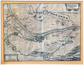
Gennep, On
01.01.1641 (do 31.12.1641)This detailed and accurate map depicts the fortress of Gennep situated on the river Moselle on the territory of present-day Belgium. The fortified town is surrounded by fortification constructions of the enemies – the Dutch. A failed attempt of the Spanish troops to free the town from the Dutch blockade is depicted on the bottom right. The above-stated inscription is placed in a square ornamental cartouche at the top right. The factual caption A-C is in a similar banner on the bottom left.
Signature: Not available
Autor: Unknown
Original name: Belägerung des vesten Schlosses und Passes Gennep.
Katalogová čísla: Collection Český Šternberk, kód: 303/408
This engraving depicts one of the last battles of the long-standing war conflict between the Netherlands and the Spanish Kingdom, lost by Spain in the end. Its defeat was due to the situation of Spain, once a very powerful medieval kingdom that was now gradually losing its powers as well as importance, and also due to Frederick Henry of Orange, outstanding ruler of the Netherlands, who excelled in the state and military matters. This statesman and genius commander was behind the great defeat of the Spanish on the land and on the sea. He besieged the Gennep fortress, occupied by the Spanish in 1641, defeated the Spanish regiments, which were trying to save the besieged town, and finally conquered the town as well as the fortress. This battle is depicted on the described copper engraving.
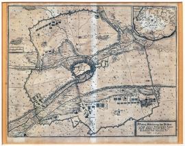
Aire sur la Lys, On
01.01.1641 (do 31.12.1641)This is a very accurate and detailed depiction of the town and its entire surroundings. It resembles a map rather than a picture. The town is circled by wide attacking formations of the French army. There is a rectangular banner with the explanatory German text on the bottom right. A map of the Northern France with the town of Aire (Arien), situated approximately 50 km southeast of Calais, is in the top left corner.
Signature: Not available
Autor: Unknown
Original name: Wahre Abbildung der vesten Statt Arien belagert und erobert durch Ludwig XIII. König zu Frankreich und Navarra im Jahr 1641.
Katalogová čísla: Collection Český Šternberk, kód: 304/267
The war between the Spain and France was still ongoing with varied intensity throughout the year 1641. France officially declared war on the Holy Roman Empire in 1635. Prior that it had been fighting rather indirectly, mainly supporting the Swedish in various ways. Now, however the French king was sending his best troops and commanders to fight the Imperial army. The French troops fought on the German territory mainly side by side with the Swedish under a joint command. For many years France had been fighting the Spanish Hapsburgs. The depicted battle between the two enemies took place in 1641, when the French led by their king besieged and conquered the town of Aire that had a strategically important position near the Spanish Netherland
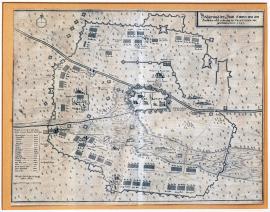
Aire sur la Lys, On
01.01.1641 (do 31.12.1641)This picture is drawn to resemble a map with the fortified town of Aire in its centre. There is the usual wide circle of fortification constructions of the conquerors – this time the Spanish. Only the main buildings are drawn in the town; the rest is only schematically sketched. An orienteering compass is at the top left. A detailed list of sizes of the individual encampments and regiments including their names is below it.
Signature: Not available
Autor: Unknown
Original name: Belägerung der Statt Arien von den Spanischen nach eroberung der Franzosen vorgenohmen. Anno 1641.
Katalogová čísla: Collection Český Šternberk, kód: 305/277
The war between the Spain and France was still ongoing with varied intensity throughout the year 1641. France officially declared war on the Holy Roman Empire in 1635. Prior that it had been fighting rather indirectly, mainly supporting the Swedish in various ways. Now, however the French king was sending his best troops and commanders to fight the Imperial army. The French troops fought on the German territory mainly side by side with the Swedish under a joint command. For many years France had been fighting the Spanish Hapsburgs. The depicted battle between the two enemies took place in 1641, when the French led by their king besieged and conquered the town of Aire that had a strategically important position near the Spanish Netherland. It remains to be said that following the conquest of Aire by Louis XIII, the Spanish attempted to get this strategic strongpoint back and were reinforced to carry out this deed by the Imperial army commanded by General Lamboy, which prior to this had operated in the area of the Central Rhineland and Holland. The described engraving depicts this Spanish-Imperial besiege of the town of Aire.
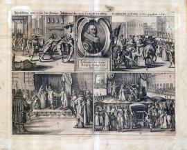
Lisabon, On
01.01.1641 (do 31.12.1641)The entire area of the picture is divided into 4 separated fields. At the top in the middle is a bust portrait of John IV of Portugal. The following scenes are in the individual fields: 1. The murder of the Castilian House ruler, the predecessor of John IV. 2. Heralds are spreading the news about the new king, John IV. 3. The oath of the king. 4. The coronation. The above-stated German explanatory text is placed above the 4 images.
Signature: Not available
Autor: Unknown
Original name: Vorbildung was zur Zeit Königs Johannes des IV. in Portugall beruffung Grönung für 4 Hauptactus gegeben 1641.
Katalogová čísla: Collection Český Šternberk, kód: 306/402
For a couple of years (since 1637) the Portuguese were increasingly unsatisfied with the rule of the Spanish Castilians. The French Chancellor Richelieu supported the Portuguese national movement (if we may imply the present-day meaning of this expression to the situation in the 17th century) intentionally and intensively, observing his own purpose to weaken the power of Spain. Finally the last ruler of Portugal, from the Castilian family of Braganza, the predecessor of John IV, was assassinated and removed from the throne. At that time the Spanish were powerless and incapable of doing nothing against this for them unfavourable change on the Portuguese throne. England, the Netherlands and other countries accepted the new Portuguese king, who personally owned about three quarters of the entire sovereign Portuguese territory.
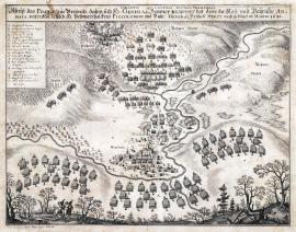
Přísečnice, On
01.03.1641 (do 31.03.1641)The engraving depicts the positions of the Imperial-Bavarian and Swedish armies near the township of Přísečnice. An unnamed stream flows through the place with the Chateau of Přísečnice on its bank. There are two buglers on horses in the left foreground, on the right is a staffage of trees. The ‚Böhmer-Wald‘ is in the background with the positions of the Swedish. It is interesting that the Přísečnice near the town of Vejprty does not lie at the foothills of the Šumava Forest but at the foothills of the Ore (Krušné) Mountains. On the other hand, the author of the engraving was the fortification engineer Carlo Cappi, and any topographical inaccuracy is out of question, based on the experience with his other prints. The explanatory Latin-German text is above the picture part of the print; the caption A-V is in a square banner on the left.
Signature: Carlo Cappi ingenieur delineavit.
Autor: Cappl Carlo, fortifikační inženýr a kreslíř plánů
Original name: Dispositio ad fauces Presnizianas. Abrisz des Posto zur Bressnitz, dahin sich H. General Banner retriert hat, deme die Kay. und Bayrische Armata unter dem Befelch H. Veldmarschalckens Piccolomini und Bayr. General Freiherrn Mercy nach gefolget im Martio 1641.
Katalogová čísla: Collection Český Šternberk, kód: 291/96
General Baner tried to attack the session of the Imperial Diet chaired by the Emperor in Regensburg in 1640/41. His daring intention failed however, as the Imperial army led by Piccolomini forced the Swedish to withdraw to the Upper Palatinate and further via Cheb to Bohemia. Baner paid for this evasive strategy with the loss of several regiments commanded by the Colonel Schlange, who held back the Imperial-Bavarian army near Neuburg on the Czech-Bavarian borders. Here the Swedish regiment was surrounded by Piccolomini and capitulated on 21 March 1642. It remains to add that the after Baner withdrew to the Czech territory the Swedish army stopped for a short rest near Přísečnice and got out of there only at the cost of great casualties (the capitulation of the Schlange’s regiment at Neuburg) and was under persisting danger of being caught and shattered by the outnumbered enemy.
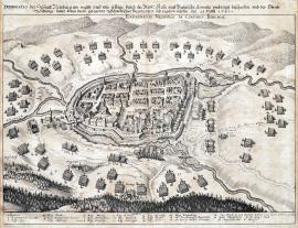
On
21.03.1641This beautiful image of the town of Neuburg in the centre of the painting was engraved exceptionally meticulously and artistically. Several small rivers, including the Schwarzach, flow around the town. There is a big dark forest in the foreground. The Imperial-Bavarian troops are positioned around the town. High forested mountains are in the background, possibly the Bohemian Forest Šumava. There is an inscription in the sky over the town:,Expugnatio Neoburgi in confinis Bohemiae‘. The factual and topographic caption 1-19 and A-C is at the bottom.
Signature: Not available
Autor: Unknown
Original name: Delineatio der Statt Neuburg am Waldt und wie selbige durch die Röm. Kay. und Bayrische Armata umbringt beschossen und der Obriste Schlange sampt der darin gelegenen Schwedischen Regimentern sich ergeben müssen den 21. Martii 1641.
Katalogová čísla: Collection Český Šternberk, kód: 290/260
General Baner tried to attack the session of the Imperial Diet chaired by the Emperor in Regensburg in 1640/41. His daring intention failed however, as the Imperial army led by Piccolomini forced the Swedish to withdraw to the Upper Palatinate and further via Cheb to Bohemia. Baner paid for this evasive strategy with the loss of several regiments commanded by the Colonel Schlange, who held back the Imperial-Bavarian army near Neuburg on the Czech-Bavarian borders. Here the Swedish regiment was surrounded by Piccolomini and capitulated on 21 March 1642.
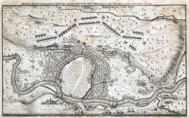
Bernburg, On
07.05.1641This schematic sketch shows the town of Bernburg situated on the Saale approx. 80 km northwest of Leipzig in Saxony. The scenery around the town dotted with many trees with the stream of Saale is painted with a good taste and in detail. The position of the Imperial troops is depicted above Bernburg. There is an inscription over the town:,Bernburgum cum situ‘. The word-for-word cited German explanatory text is above the picture part of the engraving.
Signature: Not available
Autor: Unknown
Original name: Abrisz der Statt Bernburg sambt der schwedischen und weymarischen, wie auch der Kayserl. Läger fortificationen und Battereien. inn Anno 1641 den 7. 17. May.
Katalogová čísla: Collection Český Šternberk, kód: 292/372
In winter 1641/2 Baner was forced by the Imperial-Bavarian army commanded by Piccolomini and Mercy to withdraw further to the northwest after his short-term occupation of some territories in Western Bohemia, including the town of Cheb. The Swedish marched to Cvikov, where they were joined by the remainders of Bernhard of Weimar’s army, commanded now by the French General Guebriant. The united army then moved to Halberstadt, where Baner soon died. He was first replaced by Pfuhla and later by Torstensson. The event depicted on this engraving took place during the described campaign through Saxony, which continued even after Baner’s death.
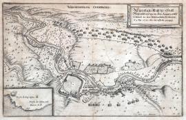
Weißenfels, On
09.05.1641This print depicts the river Saale flowing through the countryside dotted with trees drawn in a similar way. The Imperial army is positioned between two villages on the right. The town of Weissenfels is in the foreground. It is only schematically sketched picture without any details of buildings. A rectangular banner with the German explanatory text is at the top right. There is an inscription in the sky over the landscape:,Weissenfelsia Occupatio. A detailed profile of a fortification construction is at the bottom left, as it is on the majority of Cappi’s engravings.
Signature: Carlo Cappi ing. Delineavit
Autor: Cappl Carlo, fortifikační inženýr a kreslíř plánů
Original name: Eigentlicher Abrisz der Statt Weissenfels und wie die Kay. Armata unter Comando des Gen. Feldmarschalls Piccolomini den 9. May 1641 über die Saale gezogen.
Katalogová čísla: Collection Český Šternberk, kód: 293/259
Following the failed daring attempt to attack the Imperial Diet called by Ferdinand III in autumn 1640 to Regensburg, the Swedish General Baner managed to escape General Piccolomini via Upper Palatinate to Western Bohemia, however at the great loss of men. After a short rest in Přísečnice below the Ore Mountains, the Swedish moved to Saxony with the Imperial forces still on their tail. The Field Marshal Piccolomini reached the river Saale near Weissenfels on 9 May 1641. He seized the town and crossed the Saale with his army to continue the pursuit of the Swedish. Weissenfels lies approximately 35 km southwest of Leipzig.
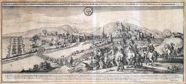
Weissenfels, On
02.06.1641This wide and very beautifully done engraving depicts the town of Kreuznach on the Rhine with a chateau atop a hill. A cavalry is wading the Rhine, a group of dragoons depicted from the back is in the right foreground. There is a coat-of-arms of the town of Kreuznach in the sky. The translated German explanatory text is placed above it. The caption A-W is at the bottom. The engraving technique and the composition of the work resemble the works by Václav Hollar. However, the picture is signed by Filip Harpffem.
Signature: Philippus Harpff fecit.
Autor: Harpff Philipp, mědirytec
Original name: Wahre Abcontafactur der Statt Kreutznach und Vestung Kreutzenberg in gleichem der beiden Schlösser Wildstatt so den 10. April und Maulburg den 18. dito wie dieselbige von dem General veldtwachtmeister Gicci de Haes seindt den 2. Juny 1641 eingenohmen worden.
Katalogová čísla: Collection Český Šternberk, kód: 294/414
The main battles were fought in the Central Germany around 1640, however some fights took place in the Western Europe, mainly on the borders between France, the Netherlands and Germany. Charles of Lorraine with the Spanish fought for the Emperor against the French-Dutch regiments commanded by Duke Frederick Henry of Orange. The depicted scene of the siege of Kreuznach on the mid-stream of the Rhine was one of those battles. The situation on these battlefields changed only after the victory of the French commanded by the General Guebriant, who crushed the Imperial army completely on 17 January 1642.
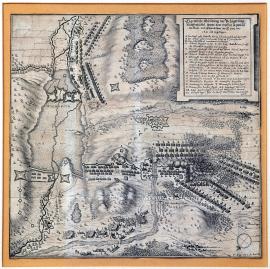
Wolfenbüttel, On
12.06.1641 (do 29.06.1641)There is a large water surface on the left side of the engraving, the town of Wolfenbüttel lies on its banks. A battle between the Swedish and Imperial regiments is just breaking out on the right. The above-stated German text and the caption A-CC in a square banner at the top right. There is an orienteering compass in the bottom right corner.
Signature: T Kluge Ob. L. der Artil. del.
Autor: Kluge Th., poručík dělostřelectva a vojenský kartograf
Original name: Eigentliche Abbildung der Belägerung Wolffenbüttel sampt dem Treffen so zwischen den Kays. und Schwedischen den 12. / 29. Juny anno 1641 sich zugetragen.
Katalogová čísla: Collection Český Šternberk, kód: 296/425
The Duke George of Brunswick was one of the German princes that followed the example of the Electorate John George I of Saxon and moved to the Imperial side after the Peace of Prague in 1635. In 1641 those of Brunswick, who supported the Swedish side, besieged Wolfenbüttel, which Governor George of Brunswick died shortly before. Piccolomini was defeated in his attempt to liberate the town from the Swedish siege, but the conquerors withdrew from the town later on anyway and signed the so-called Goslar Agreement with the Emperor on 6 January 1642. The described engraving depicts the siege of Wolfenbüttel by the anti-Imperialistic Brunswicks and the battle between the Piccolomini and Swedish armies on 12/29 June 1641, which was lost by the Imperial army.
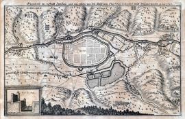
Cvikov, On
19.06.1641There is hilly countryside in the picture with a schematic sketch of the town of Cvikov above Cvik. Modlou. A large lake lies outside the town at the bottom right. A cross-section of a fortification construction is drawn in a special banner. There is an inscription: ‚Obsidio Zwiccaviae‘ at the top left.
Signature: Not available
Autor: Unknown
Original name: Grundrisz der Statt Zwickaw und wie solche von den Kays. ind Chur. Säx. commandierten Volck belägert worden. 19. Juny 1641.
Katalogová čísla: Collection Český Šternberk, kód: 295/361
While withdrawing from Bavaria via Upper Palatinate and Western Bohemia in winter 1640/41 the General Baner entered Saxony and occupied Cvikov. However, Piccolomini and Mercy arrived before long with the Imperial-Bavarian army and Baner kept running, this time to the northwest. He occupied Halberstadt where he was joined by the French army commanded by the General Guebriant. General Baner died in Halberstadt on 10 May and was replaced first by Pfuhl and later by Torstensson. Swedish garrison remained in Cvikov, however the town was besieged and conquered on 19 June.
Wolfenbüttel, On
19.06.1641There is a large water surface in the picture, the town and fortress of Wolfenbüttel lies on an island in its centre. A battle between the two enemies is being fought on the left, some of the soldiers are running away from it already. There is a scene with a group of officers with two typical musketeers in the left foreground near two trees. The caption 1-12 is in an ornamental banner at the bottom right.
Signature: Not available
Autor: Unknown
Original name: Eigentlicher Abrisz der Vestung Wolffenbüttel sampt dem Treffen so zwischen den Kayserl. und Schwedischen völker darvor gehalten, den 19. Junii 1641.
Katalogová čísla: Collection Český Šternberk, kód: 297/43 D
The Duke George of Brunswick was one of the German princes that followed the example of the Electorate John George I of Saxon and moved to the Imperial side after the Peace of Prague in 1635. In 1641 those of Brunswick, who supported the Swedish side, besieged Wolfenbüttel, which Governor George of Brunswick died shortly before. Piccolomini was defeated in his attempt to liberate the town from the Swedish siege, but the conquerors withdrew from the town later on anyway and signed the so-called Goslar Agreement with the Emperor on 6 January 1642. The described engraving depicts the siege of Wolfenbüttel by the anti-Imperialistic Brunswicks and the battle between the Piccolomini and Swedish armies on 12/29 June 1641, which was lost by the Imperial army.
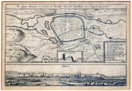
Osterwieck, On
06.08.1641This is a schematic sketch of the town of Osterwieck situated above the river Ilse which flows into the river Ockera. Osterwieck lies approx. 40 km south of Brunswick. The town is surrounded by various streams that divide the hilly countryside. The caption A-H is in a separated banner on the right. There is a cross-section of the fortification at the bottom centre. An unusual panoramic view of Osterwieck is below the plan reaching across the entire length of the picture.
Signature: Not available
Autor: Unknown
Original name: Die Statt Osterwickh von dem Kays. und bayr. Kriegsvolck eingenommen den 6. August 1641.
Katalogová čísla: Collection Český Šternberk, kód: 298/378
While running away hastily from Bohemia via Saxony to Brunswick, General Baner was pursued by the Archduke Leopold Wilhelm and the Marshal Piccolomini. However, Baner died in May 1641 in Halberstadt and was soon replaced by Leonard Torstensson. The Imperial army, which was chasing out the Swedish from Bohemia right up to Brunswick, seized Cvikov on 9 June (near the Czech border in Saxony), but was defeated at Wolfenbüttel by the Swedish. However, the town remained occupied by the Imperial garrison. Piccolomini’s defeat was compensated by the Goslar Agreement, signed between the Brunswick princes and the Emperor. The Imperial army further managed to seize the town of Osterwieck on 6 August. The described picture depicts this event.
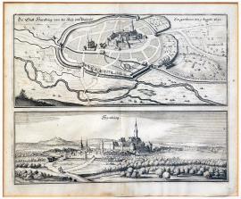
Hornburg, On
09.08.1641The entire print is divided down the middle into two individual views. The top view depicts the city with the fortification walls from the so-called bird’s eye perspective. There are 4 cannons firing at the city from the right. The landscape outside the town is separated by several branches of the river Ilse. Hornburg is also depicted in the bottom part of the picture together with a chateau with a high tower reaching above the level of the town. A cavalryman is standing is some bushes in the foreground. In the background is a castle atop a hill.
Signature: Not available
Autor: Unknown
Original name: Die Statt Hornburg von den Kay. und Bayrisch. eingenommen den 9. Augusti 1641.
Katalogová čísla: Collection Český Šternberk, kód: 299/271
Pursued by the Archduke Leopold Wilhelm and Marshal Piccolomini, Baner was hastily withdrawing from Bohemia across Saxony and up to Brunswick. However, Baner died as early as May 1641 in Halberstadt and was replaced after a while by Leonard Torstensson. The Imperial army, which chased the Swedish out of Bohemia to Brunswick, seized the town of Cvikov (in Saxony near the Czech borders) on 9 June but was defeated by the Swedish near Wolfenbüttel on 19 June. Yet the town remained occupied by the Imperial garrison. Piccolomini’s defeat was compensated by the Goslar Agreement, signed between the Brunswick princes and the Emperor. The Imperial forces managed to conquer the town of Osterwieck on 6 August during the ensuing military campaign. This battle is depicted on the described picture. It remains to be said that Hornburg, situated approximately 30 km south of Brunswick, was seized by the Imperial forces on 6 August 1641, therefore at the almost same time as Osterwieck.
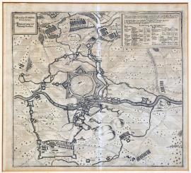
Dorsten, On
20.09.1641This is a very accurate map of the situation of the town of Dorsten, situated on the river Lippe in Westphalia, and its surroundings. The Lippe flows across the middle of the picture; the town of Dorsten, surrounded by a regular fortification system, is on its right bank. The centre of the town is only schematically sketched. The above stated inscription is in a square banner on the top left. There is a detailed list of all besieging regiments and encampments numbered 1-11 on the right.
Signature: Not available
Autor: Unknown
Original name: Obsidio Fortalitij Dorstenij.
Belägerung der Vestung Dorsten.
Katalogová čísla: Collection Český Šternberk, kód: 300/108
Before the important Battle on the Kempen’s Field on the Holland-Belgium borders, fought between the regiments of the Elector Archbishop of Cologne, commanded by Lamboy, and the Swedish army, reinforced by the regiments of some Protestant German princes, on 17 January 1642, the Cologne Archbishop demanded the Imperial General Hatzfeld to come to his help. The Imperial army led by Hatzfeld operated in Westphalia at that time, conquering a number of strongpoints, including the town of Dorsten on the river Lippe, which was besieged from 21 July to 20 September 1641. Only after that the army went to support Lamboy. Hatzfeld met the Cologne Elector in Bonn, however it was too late to help Lamboy.
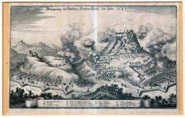
Hohentwiel, On
08.10.1641The Hohentwiel fortress sits on a steep hill and is surrounded by the charging Imperial troops. The depicted landscape is mountainous and forested. Clouds of smoke from firing batteries hang around the fortress. The cannonballs ballistic trajectories are ending in the walls of the fortress. The factual caption A-M is on the unrolled ribbon banner.
Signature: Not available
Autor: Unknown
Original name: Belägerung der Vestung Hochen-Twiel im Jahr 1641.
Katalogová čísla: Collection Český Šternberk, kód: 301/356
The Hohentwiel castle is situated approximately 30 km northwest of Lake Constance. The pressure on the armies situated on the upper Rhine lifted after the failure of Baner’s daring plan to attack the session of the Imperial Diet in Regensburg, and the Swedish army was gradually pushed away right up to Brunswick by the army of the Archduke Leopold Wilhelm and the General Piccolomini. Thus the Imperial troops got engaged in the fights once again and looked around for an enemy that could be attacked. The French occupied the Hohentwiel castle near Lake Constance. The Imperial troops besieged and conquered it on 8 October.
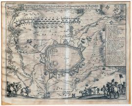
Einbeck, On
20.10.1641The town of Eynbeck, situated in Brunswick approximately 40 km south of the town of Hidesheim, is schematically outlined in the centre of the plan. We can see two fires in the town. The army formations and enemy’s fortification constructions are lined-up around the town. The picture also depicts some landscape details and various scenes in detail. There is a rectangular banner with the caption A-Q at the far right of the picture. In the foreground are three dragoons holding battle standards with the Imperial Eagle on one of them. A bugler is nearby to the left.
Signature: Not available
Autor: Cappl Carlo, fortifikační inženýr a kreslíř plánů
Original name: Grundrisz der Statt Eynbeck und wie die von der kays. und bayr. Armata belägert unter ihrer hochfürstlichen Durchlaucht Ertzherz. Leopold Wilhelmo und Direction Ihr. Excel. General-Feldmarschallen Duca Piccolomini den 20. / 10. Octobris 1641.
Katalogová čísla: Collection Český Šternberk, kód: 302/390
Pursued by the Archduke Leopold Wilhelm and Marshal Piccolomini, Baner was hastily withdrawing from Bohemia across Saxony and up to Brunswick. However, Baner died as early as May 1641 in Halberstadt and was replaced after a while by Leonard Torstensson. The Imperial army, which chased the Swedish out of Bohemia to Brunswick, seized the town of Cvikov (in Saxony near the Czech borders) on 9 June but was defeated by the Swedish near Wolfenbüttel on 19 June. Yet the town remained occupied by the Imperial garrison. Piccolomini’s defeat was compensated by the Goslar Agreement, signed between the Brunswick princes and the Emperor. The Imperial forces managed to conquer the town of Osterwieck on 6 August during the ensuing military campaign. This battle is depicted on the described picture. It remains to be said that Hornburg, situated approximately 30 km south of Brunswick, was seized by the Imperial forces on 6 August 1641, therefore at the almost same time as Osterwieck. The town of Einbeck was conquered by the Imperial army on 10 / 20 October 1641, therefor after the defeat of Piccolomini near Wolfenbüttel. Einbeck is situated in Brunswick approximately 40 km south of Hildesheim.
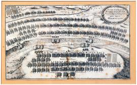
Lérida, On
01.01.1642 (do 31.12.1642)The engraving shows a schematic depiction of the formations of the French and Spanish armies divided by a deep trench. The artilleries are cannonading from both sides of the trench. There is a stream in the background; nearby are the Spanish cuirassiers ready to attack and reserve troops. There is an oval cartouche at the top right with the Latin explanatory text.
Signature: Not available
Autor: Unknown
Original name: Acies Gallicae et Hispaniae prope Ileridam quando Marschallus quodam courtius Marchionem de Legacz fugavit. Schlacht bey Lerida.
Katalogová čísla: Collection Český Šternberk, kód: 316/107
After 1640 the French started winning the long war between France and Spain, pushing their enemy into defensive on the battlefields in Italy, the Spanish Netherlands and the Pyrenees. The depicted battle of Lerida in Catalonia in the Northern Spain took place in 1642.
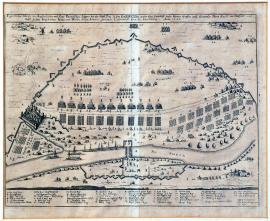
Zons, On
01.01.1642 (do 31.12.1642)The picture depicts the Rhine spanned by a large bridge with an army encampment behind it. Nearby is the town of Zons on the Rhine. There are interesting minor scenes in various places of the engraving, mostly of the military topic: i.e. the guard exchange, passing-by generals, groups of speaking officers etc. The extensive word-for-word cited German explanatory text is above the picture; the topographical and factual caption A-X and 1-24 is below it.
Signature: Not available
Autor: Unknown
Original name: Eigentlicher Abrisz des kayerlichen und chur-bayrischen Lägers bey der Statt Zons in dem Erzstift Cöllen under dem Commando des Herrn Grafen und Generals Ihr. Excel. von Hatzfeld und Wahl so dann Freiherrn von Wörth beder Arméen Generalen Leutnapt über die Cavallerie, Anno 1642.
Katalogová čísla: Collection Český Šternberk, kód: 317/422
The army of the Elector Archbishop of Cologne was defeated in the Battle of the Kempen’s Field on 17 January 1642 by the allied army, commanded by the General Guebriant. General Lamboy, the commander of the defeated army, was captured in the battle. Guebriant achieved his victory mainly because he attacked the enemy before they could call for reinforcements – troops of generals Hatzfeld and Werth, who were positioned on the Mid-Rhine. Guebriant ordered the Hessian regiments to defend the conquered territory and marched with the French and other groups to Thuringia to support Torstensson, who was endangered by the Imperial army (before the so-called second Battle of Breitenfeld). The depicted camp near Zons was a kind of a base camp of the Imperial generals Hatzfeld and John of Werth on the mid-Rhine before they invaded the area of the lower Rhine.
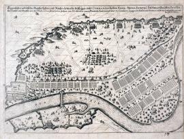
Zons, On
01.01.1642 (do 31.12.1642)This engraving is almost identical with the picture registered under No. 317/422 on the previous list, however the German explanatory text is slightly different and it lacks the caption and letters that mark individual details of the picture.
Signature: Not available
Autor: Unknown
Original name: Eigentlicher Abrisz des Keyserlichen und Reichs-armada Veltlägers unter Commando beider Excel. Herrn General Veldmarschalken Graffen von Hatzfeld und Grafen von Wahl, so dan Freyherrn Johan von Wörth beder Arméen Generalen Leutenampt uběr die Cavallerie so gegen die Hessen und Weimar-völkr bey Zons geschlagen und fortificiert worden.“
Katalogová čísla: Collection Český Šternberk, kód: 317a/481D
The army of the Elector Archbishop of Cologne was defeated in the Battle of the Kempen’s Field on 17 January 1642 by the allied army, commanded by the General Guebriant. General Lamboy, the commander of the defeated army, was captured in the battle. Guebriant achieved his victory mainly because he attacked the enemy before they could call for reinforcements – troops of generals Hatzfeld and Werth, who were positioned on the Mid-Rhine. Guebriant ordered the Hessian regiments to defend the conquered territory and marched with the French and other groups to Thuringia to support Torstensson, who was endangered by the Imperial army (before the so-called second Battle of Breitenfeld). The depicted camp near Zons was a kind of a base camp of the Imperial generals Hatzfeld and John of Werth on the mid-Rhine before they invaded the area of the lower Rhine.
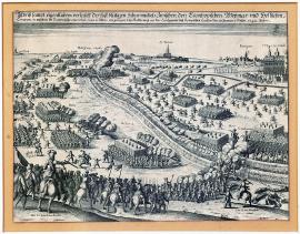
Kempen, On
17.01.1642This picture depicts a landscape with a deep ditch across it. The Lamboy’s regiments are on its right side, while the Swedish-Weimar-Hesse-French army is situated on the other side. The ditch is spanned by two bridges. Fierce fights are going on both of them. The town of Kempen is on the right. Willich is outlined on the far left of the print. General Guebriant mounted on a horse is at the bottom left. On the right side amongst dead bodies lies the corpse of the Colonel Flermersheim. Many officers are marked with their names.
Signature: Not available
Autor: Unknown
Original name: Abrisz sampt eigentlichem verlauff des fast blütigen Scharmützels zwischen den Lamboyischen, Weymar, und Hessischen Troupen, in welchem die Lamboyische eine total ruin erlitten: vorgangen bey Kukelsmey an der Landgewehr dess Krempischen Landes den 17. January dieszes 1642 Jahrs.
Katalogová čísla: Collection Český Šternberk, kód: 307/97
Following the defeat of Piccolomini in the Battle of Wolfenbüttel on 19 June 1641 and the death of the Swedish General Baner in Halberstadt, the French General Jean Baptiste Conte de Guebriant marched with his army to the lower Rhine, where he was joined by the Hesse-Kassel troops commanded by the Count Eberstein. This was the territory of the Archbishop Elector of Cologne, who had an army of 9000 men, commanded by the General Lamboy and operating in the area between Hulst and Kempen (in the place of the present-day borders between Belgium and the Netherlands). Guebriant was afraid that Lamboy’s army could be reinforced by the regiments of the General Hatzfeld, who was called to help the Archbishop Elector of Cologne. He therefore ordered his troops to attack the enemy across the deep boundary ditch without delay. The fight that broke out is called the,Battle of the Kempen’s Field. Lamboy’s army was completely crushed in the battle. Lamboy was captured, as was General Mercy, who one year ago served the Bavarian Elector and pursued the Baner’s army across the entire Germany together with Piccolomini. Moreover, 16 colonels, many officers and 3000 men died on the battlefield. The winners seized 6 cannons, many battle standard and banners and all the supplies. The Imperial General Hatzfeld did not manage to come on time. The Battle of the Kempen’s Field was fought on 17 January 1642.
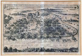
Kempen, On
17.01.1642This is a picture of the battle fought across a long borderline ditch that leads in a large curve as far as Hulst in Flanders. This battle is usually called the,Battle of Kuckelsmei’ or the ‘Battle on the Kempen’s Field’. A large group of the cuirassiers is in the foreground of the picture. The caption is missing on this print. The German explanatory text is on an unrolled ribbon banner at the top.
Signature: Not available
Autor: Unknown
Original name: Abbildung des Treffens zwischen den Kayserl. und Weimarischen Französischen Arméen unter Commando deren General Lamboy und Guebriant den 17. Januarii 1642.
Katalogová čísla: Collection Český Šternberk, kód: 308/409
Following the defeat of Piccolomini in the Battle of Wolfenbüttel on 19 June 1641 and the death of the Swedish General Baner in Halberstadt, the French General Jean Baptiste Conte de Guebriant marched with his army to the lower Rhine, where he was joined by the Hesse-Kassel troops commanded by the Count Eberstein. This was the territory of the Archbishop Elector of Cologne, who had an army of 9000 men, commanded by the General Lamboy and operating in the area between Hulst and Kempen (in the place of the present-day borders between Belgium and the Netherlands). Guebriant was afraid that Lamboy’s army could be reinforced by the regiments of the General Hatzfeld, who was called to help the Archbishop Elector of Cologne. He therefore ordered his troops to attack the enemy across the deep boundary ditch without delay. The fight that broke out is called the,Battle of the Kempen’s Field. Lamboy’s army was completely crushed in the battle. Lamboy was captured, as was General Mercy, who one year ago served the Bavarian Elector and pursued the Baner’s army across the entire Germany together with Piccolomini. Moreover, 16 colonels, many officers and 3000 men died on the battlefield. The winners seized 6 cannons, many battle standard and banners and all the supplies. The Imperial General Hatzfeld did not manage to come on time. The Battle of the Kempen’s Field was fought place on 17 January 1642.
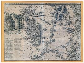
Düren, On
10.04.1642The picture is divided by the river Ruhr into two parts, which depict the battle in much detail. Many villages and settlements in the surroundings are marked by their names. The town of Düren is at the top of the print, while the town of Jülich lies above the river Ruhr at the bottom. The majority of the area of the depicted landscape is forested; the forest is outlined by the typical round treetops. The German explanatory text is above the picture. The topographical and factual caption A-V is at the bottom left.
Signature: Phil. Harpff fecit.
Autor: Harpff Philipp, mědirytec
Original name: Eigentliche Abbildung des Hessischen Einfalls in der Lothringer Quartier und wie ritterlich die Lottring. von H. Grafen von Nassau neben dem Obersten Mandelsloh secundiert, dass der Feind gänzlich geschlagen worden, den 10. April 1642.
Katalogová čísla: Collection Český Šternberk, kód: 309/404
The victory of the allies (the French, Swedish, Hessian and Kassel troops) on 17 January 1642 over the army of the General Lombay confused and petrified the inhabitants of the territories along the lower Rhine. The winner of the Battle of the Kempen’s Field, General Guebriant, received the Marshal baton for his success. Then he left the Hessian troops to protect the conquered territories against General Hatzfeld and marched with this Swedish-French army to Thuringia to support Torstensson. The Lorraine troops successfully fended off an attack of the Hessian troops on their encampment on the lower Rhine. This battle, fought on 10 April 1642, is depicted on this engraving.
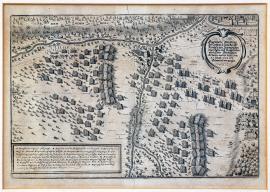
Schweinitz, On
21.05.1642This is a depiction of two phases of the battle – placed on both sides of the print. There are several small streams in the picture. At the top right is an ornamental cartouche with the German explanatory text. Above it lies the town of Schweidnitz. The extensive caption A-R is at the bottom left.
Signature: Not available
Autor: Unknown
Original name: Eigentliche Abbildung des Treffens so zwischen der königlichen Schwedischen eines theils und Kayserlichen auch Chur-Sächsischen Armmen anderstheils den 21. May 1642 bey Schweinitz vorgengen.
Katalogová čísla: Collection Český Šternberk, kód: 310/397
Before the Swedish general Torstensson, the successor of Baner, sat out to Moravia and continued southwards to Austria at the beginning of 1642, he occupied most of the Silesian territories, the same from which his colleague General Stalhantsch had to withdraw earlier. Torstensson appeared unexpectedly near Glogów and conquered the town. Then he defeated the Duke Franc Albert Saxon-Lauenburg in the Battle of Schweidnitz. The Duke Saxon-Lauenburg, who died on the battlefield, had a very bad reputation in the Imperial army, for he was known to be a confidant to Wallenstein and a supporter of his anti-Imperial conspiracy.
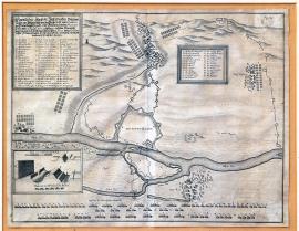
Glogow, On
04.08.1642 (do 10.08.1642)The engraving schematically depicts the town Glogów above the Oder river with the enemy’s formations spread in the surroundings. A separated banner with the inscription and factual and topographical caption A-Z and 1-19 is in the top left corner. A detail of a fortification construction with a scale is at the bottom left. The caption continues at the top right with numbers 20-48.
Signature: Not available
Autor: Unknown
Original name: Eigentlicher Abrisz der Statt Grossen-Glogaw sampt der belagerung von den Kayserlichen unter Conduicti des Ertzherzogen Leopoldi und Feldmarschallen Piccolomini so von dem 4. Augusti 1642 bis den 10. desselben Monats gewehret, da sie von der königl. schwedischen Armée unter Conduicti dessen Feldmarschallen Torstenson Excellenz vermittels göttlichen Beystandes ist entsetzet worden.
Katalogová čísla: Collection Český Šternberk, kód: 311/429
The Swedish commanded by Torstensson invaded Silesia and Moravia in 1642 with the intention to attack Vienna. However, the Imperial army commanded by the Archduke Leopold Wilhelm and Piccolomini forced Torstensson out of Moravia and back to Silesia keeping a close pursuit. The Imperial army was besieging Glogów from 4 till 10 August. However, unsuccessfully as the Swedish managed to free the town from the siege. These fights took place before the great Battle of Breitenfeld near Leipzig, which was fought on 6 November 1642, and ended by a serious defeat of Archduke Leopold and General Piccolomini. The same happened in the first Battle of Breitenfeld, fought on 17 September 1631, in which the Swedish King Gustav Adolph defeated the General Tilly.
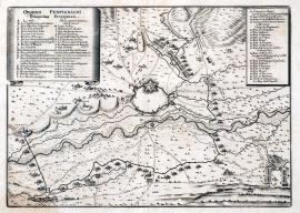
Perpignan, On
09.09.1642This is an extraordinary and very delicate engraving, which depicts the city of Perpignan above the river Le Tet in its centre. There are army regiments, fortifications and several villages in the surroundings. There is an extensive factual and topographical caption A-W, 2-22 and 22-42 on the unrolled ribbon banner.
Signature: Not available
Autor: Unknown
Original name: Obsidio Perpigniani – Belägerung Perpignian.
Katalogová čísla: Collection Český Šternberk, kód: 312/47 D
Perpignan is the main city of the Pyrenees-Orientales Department. It once belonged to Aragon and for some time it was also the continental capital of the Mallorca Kingdom. It was occupied by the Spanish in 1642. The French army commanded by Turenne besieged the city and conquered it on 9 September 1642.
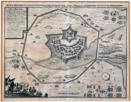
Perpignan, On
09.09.1642The fortified city and chateau of Perpignan is in the centre of the print. The trenches of the Royal army are built in a curve around the city; there are many military formations and encampments in the surroundings. An orienteering compass is at the bottom right. The explanatory text is at the top. In the left foreground are two buglers and a charging cavalry regiment. Above that is the extensive topographical and factual caption 1-18. There is also a scale stated on the print.
Signature: Not available
Autor: Unknown
Original name: Abrisz der Statt und Zitadelle Perpignan sampt dem Stand der königl. Armée, Ihren Linien, Hauptwachten und der von Ihr. Majestät gemachten Circumvallation, dediciert dem Herrn Marechal von Schönberg Hertzogen von Alluin.
Katalogová čísla: Collection Český Šternberk, kód: 313/426
The first years of the third decade of the Thirty Years’ War brought several important successes to France, which was ruled politically as well as military by the genius statesman Minister Richelieu. After the death of Cardinal Infant Ferdinand (November 1640) the ruling of the Netherlands went to Francisco de Melos, who by no means had the abilities of his predecessor. The French conquered Arras in August 1640. The Spanish were completely ousted out of Peimont in Italy and partially also from the Duchy of Milano. Guebriant won a couple of battles over the Imperial army in Germany. However, the French army also conquered Perpignan, the capital city of the Roussillon County, which the Spanish held for 150 years. The French conquerors were commanded by Marshal of Schönberg, while the Spanish troops in Perpignan were led by General Margrave Don Florés d´Avilla. Some sources mention General Turenne to be the French commander in Perpignan, however he was undoubtedly subordinated to Schönberg. Perpignan fell on 9 September 1642.
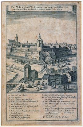
Lipsko, On
14.10.1642 (do 26.11.1642)This letter-format picture outlines the Pleissenburg fortress with its main tower shot through. The Swedish artillery batteries are positioned outside the chateau cannonading it. The buildings in the town are also occupied by the Swedish who are shooting at Pleissenburg from firearms. There are various minor military scenes depicted in the streets of the town. The German explanatory text is placed above the picture, the caption A-P is below it.
Signature: Not available
Autor: Unknown
Original name: Das veste Schloss Pleissenburg zu Leipzig und wie solches von den Schwedischen zur Uibergab bezwungen worden Anno 1642.
Katalogová čísla: Collection Český Šternberk, kód: 315/394
The defeated Imperial army withdrew southwards to Bohemia following the decisive victory of the Swedish in the second Battle of Breitenfeld on 2 November 1642. Meanwhile, the Swedish besieged the Leipzig. The circumstances forced Torstensson to take this step his army was unable to pursue the defeated enemy to the south due to its high loss of men in the Battle of Breitenfeld. Moreover, he did not want to miss an opportunity to get loot from the city renowned for its wealth. The described engraving depicts this fighting episode. A bloody execution of the Imperial cavalry regiment called Matloch, which first turned back and ran from the battle, was carried out near the town of Rokycany. Archduke Wilhelm and General Piccolomini ordered beheading of most of the officers of this regiment. Moreover, every tenth man was shot to death.
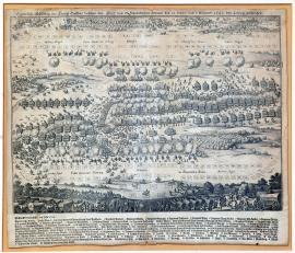
Lipsko, On
23.10.1642 (do 02.11.1642)The picture depicts a raving battle between the two enemies displaying the positions of the Imperial and Swedish troops quite well. The above-stated German text is above the picture. Directly in the picture is an inscription:,Praelium ad Lipsiam’. In the foreground are the Imperial cuirassiers and a very extensive topographical and factual caption 1-46, A-W and A-M. It lists in detail the names of all regiments that participated in the battle (from the Swedish and the Imperial armies).
Signature: Not available
Autor: Unknown
Original name: Eigentliche Abbildung des Haupttreffens zwischen den Kayserlichen und Schwedischen Arméen den 23. Oktober und 2. November 1642 zu Leipzig geschehen.
Katalogová čísla: Collection Český Šternberk, kód: 314/392
Swedish General Torstensson, the successor of Baner, was an unusually gifted commander who exceeded his predecessor in many ways. At the beginning of 1642 Torstensson led his army to Silesia occupying most of the country, which up to then had been occupied and controlled by the Imperial forces. From there he marched southwards across the entire Moravia to Vienna. However, the Imperial army commanded by the Archduke Leopold Wilhelm and General Piccolomini forced the Swedish out of Moravia and to the northwest; Torstensson therefore marched across Silesia to Saxony, conquered the towns of Zittau and Torgau and was getting close to Leipzig with the intention to occupy it as well. The Imperial forces had no intention to allow Leipzig, which had not seen enemy for 10 years, being conquered by the Swedish and therefore stood up to the Swedish near Leipzig. Thus, near the well-known Breitenfeld (the place of the Battle of Breitenfeld where Gustav Adolf defeated General Tilly in September 1631), the second Battle of Breitenfeld (or of Leipzig) took place on 2 November 1642. And once again the Imperial army was completely crushed. The Swedish captured approximately 5000 men and about the same number of Imperial soldiers died on the battlefield. The winners also seized a large number of banners and battle standards and 46 cannons, and lost approximately 4000 men, who either died or were wounded.
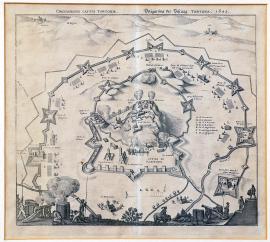
Tortona, On
01.01.1643 (do 31.12.1643)The town with the Tortona citadel is in the centre of the engraving. It is walled by double bulwark. This is undoubtedly the last phase of the siege as cannons firing at the citadel are already placed inside the town. The caption A-G is on the right side of the print. There are several cannons and cavalrymen in the foreground.
Signature: Not available
Autor: Unknown
Original name: Belägerung der Vestung Tortona 1643.
Katalogová čísla: Collection Český Šternberk, kód: 329/460
Unprecedented growth of the social and cultural life was typical for France of the second half of the 17th century. We can observe diplomatic as well as military success and a boom of arts and literature. Soon the dynamic France felt restricted by its neighbour, Spain, a slowly declining world power. As a result lengthy war conflicts were erupting with France coming up the winner in the end. The declining Spain was gradually pushed out of all its domains, mostly in the Netherlands and Italy. This engraving depicts a minor scene from these French-Spanish relations, the siege of the town of Tortona, situated approximately 50 km north of Geneva, in 1643.
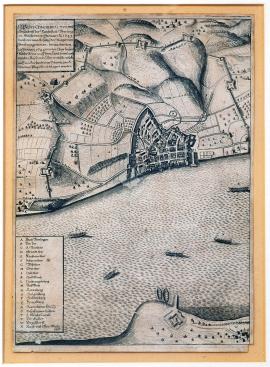
Überlingen, On
30.01.1643This is letter-format picture showing Lake Constance with the town of Überlingen on its banks. There are several boats on the lake. The extensive German explanatory text is at the top left; the caption A-X is below.
Signature: Not available
Autor: Unknown
Original name: Wahre Conderfactur und Grundriss der Reichstatt Uberlingen, welche den 30. Janurari A. 1643 durch Verwaarlosung der Bürger vom Feindt eingenommen, hernach den 29. Januarii 1644 von den Churbayrischen Reichs-armée auff dem Land sowohl auch von den Keys. Osterreichischen Völkern auff dem See sampt einer Schantz zu S. Nicolaus ploquiert und belägert worden.
Katalogová čísla: Collection Český Šternberk, kód: 318/417
General Guebriant stood only with a small army in the area of the upper Rhine at the turn of 1642 an 1643 because he left his allies from the Battle of the Kempen’s field, the Hessian and Kassel regiments, on the lower Rhine to protect the conquered territories against Hatzfeld and Werth, who encamped near Zons. The Swedish, commanded by Torstensson, were far away in the Central Germany. Using this situation Guebriant seized the badly protected and defended town of Überlingen on 30 January 1643. However, the French only kept the town for one year as ti was re-occupied by the Imperial troops on 29 January 1644.
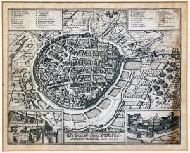
Freiberg, On
01.02.1643 (do 28.02.1643)The town of Freiberg is drawn in detail in the centre of the print on a round ground-plan. There are a couple of lakes on the right with the Swedish army attacking the town from this direction. There are two banners with the captions A-S and T-k at the top right and left. There are individual drawings of some buildings and fortifications in the town at the bottom.
Signature: Not available
Autor: Unknown
Original name: Die Statt Freiberg in Meissen sampt der Belägerung Anno 1643.
Katalogová čísla: Collection Český Šternberk, kód: 319/355
Following the victory in the second Battle of Breitenfeld on 2 November 1642 and the successful siege of Leipzig, Torstensson marched with the Swedish army to Bohemia in December 1642. However, he did not march via Cvikov deciding instead on Freiberg, as he was told the town had such bad supplies that it would not withhold any blockade for longer than a mere week. Still, for a couple of weeks Torstensson was attempting to conquer the town without any result as it was withholding heroically. Upon hearing that Piccolomini was getting closer with the Imperial army and had already seized the town of Dippoldiwalde, the Swedish stopped the siege of Freiberg. Later Torstensson invaded Bohemia, however stayed only for a short time, as a war broke out between Sweden and Denmark and he was called to different battlefields.
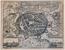
Zittau, On
21.03.1643 (do 30.04.1643)The town of Zittau spread on a ground-plan is in the centre of the engraving surrounded by various water streams, gardens and fortification constructions. The town’s coat-of-arms is on the right. The above-stated and word-for-word cited brief German explanatory text is above it. There is a caption A-X in two places at the bottom. There are also two details of important town buildings in two individual fields.
Signature: Not available
Autor: Unknown
Original name: Die Statt Zittau in der Oberlausitz, wie sie Anno 1632 vom Obersten Goltzen fortifiziert worden sampt der Belägerung Anno 1643.
Katalogová čísla: Collection Český Šternberk, kód: 320/413
Following his victory in the second Battle of Breitenfeld in autumn 1642 Torstensson did not pursue the defeated Imperial army commanded by Archduke Leopold and General Piccolomini southwards, but stayed in Saxony and Lusatia to replenish the devastated army as well as to conquer and pillage the rich city of Leipzig. By setting a couple of basis at the rear of his army, he prepared strategic prerequisites for his military campaign to Bohemia, which peaked by the Battle of Jankov in 1645. The siege and conquest of Zittau by the Swedish army commanded by Torstensson during spring moths of 1643 was part of these strategic arrangements. This military episode is depicted on our copper engraving.
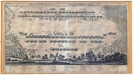
Rocroy, On
19.05.1643The picture depicts the position of the Swedish and French armies. A forest lies on the right, swamps on the left. There is an impressive detail of a broken tree in the left foreground. There are several carriages and three resting soldiers in the right foreground. The above-cited Latin-German inscription is placed above the picture.
Signature: Not available
Autor: Unknown
Original name: Ordo et praelium apud Rocroy.
Ordnung und Schlacht bei Rocroy, 1643.
Katalogová čísla: Collection Český Šternberk, kód: 321/416
During the third decade of the Thirty Years’ War France started winning the lengthy war with Spain noting a number of remarkable victorious fights defeating thus the once political and military power, Spain, which was now gradually losing its powers. Rocroi is situated in the Ardennes French department. The depicted battle took place on 19 May 1643. The defeated Spanish army was commanded by the Governor of the Spanish Netherlands, Francisco de Mello, while the French army was led by the French General Prince d’Enghien, the Duke of Condé, the so-called,Le Grand Condé’. Rocroi was one of his first victories that launched his later military fame. He was only 20 years old at this time.
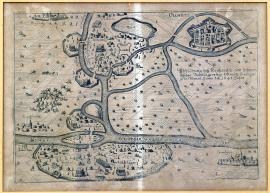
Olomouc, On
01.06.1643 (do 30.06.1643)The fortified city of Olomouc is at the top right, next to it is the Swedish encampment. There are several small water streams in the surroundings. The Imperial encampment is at the very edge of the engraving. Nearby to the right are the towns of Kroměříž and Prostějov. The German explanatory text is above the picture.
Signature: Not available
Autor: Unknown
Original name: Abbildung des kayserisch und schwedischen Veldlägers bey Ollmütz so vorgangen im Junio 1643.
Katalogová čísla: Collection Český Šternberk, kód: 322/441
General Torstensson with his army invaded Bohemia from Bautzen via Turnov and Bělá in April 1643. However, there was no battle between the Swedish army and the Imperial troops commanded by Gallas. Following various strategic manoeuvres leading as far as Prague, Torstensson marched to Moravia via Český Brod, Kutná Hora and Litomyšl, where he encamped near Olomouc not far from the encampment of the Imperial army. The engraving depicts this situation dated in June 1643. However, the Swedish army was soon recalled and moved far to the north at the beginning of autumn, as Sweden declared war on Denmark.
Thionville, On
03.06.1643 (do 10.08.1643)This is a very delicate copper engraving depicting the area around the town of Diedenhofen (Thionville) near Metz. The river Moselle flows across the centre of the picture westwards. Diedenhofen is walled by a fortification system. The town centre is unfilled. The fortifications of the conquerors circle the town widely. There are several camps and army line-ups further away from the town. A battle between cavalries is depicted right next to the town. A detail of a fortification construction is in a separated banner. The above-stated inscription is placed in a small square banner on the right.
Signature: Not available
Autor: Unknown
Original name: Obsidio villae Theodonis fortality 1643.
Belagerung der Vestung Diedenhofen.
Katalogová čísla: Collection Český Šternberk, kód: 323/26
The last decade of the Thirty Years’ War was typical for the increasingly more intensive interventions of France into the war. The conquest of Breisach in 1638 gave France an opportunity to further intervene in the war, which the country took on with a full force. General Guebriant, the winner of the Battle of the Kempen’s Field in 1642 intended to invade Thuringia, where he would join Torstensson’s army. However, Generals Hatzfeld and John of Werth blocked his way, threatening the Diedenhofen (Thionville) fortress at the same time. This fortress seemed strategically important to the French. Guebriant’s tactic was to keep the army of Hatzfeld and Werth busy while other French troops, commanded by Louis II de Bourbon Prince de Condé (the so-called,Le Grand Condé’), besieged the Diedenhofen fortress on 3 June 1643 and conquered it on 10 August. Condé was only 22 years old at that time. Only ruins were left of the town and fortress; the garrison was allowed to retreat with honour.
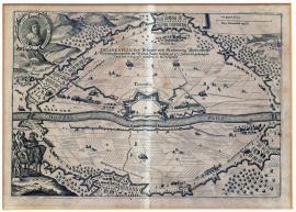
Thionville, On
03.06.1643 (do 10.08.1643)The river Moselle flows across the centre of the depicted landscape with the town of Diedenhofen (Thionville) on its bank. The fortifications of the conquerors circle the town widely. An oval portrait of the Duke of Condé is in the top left corner. At the top right is a scale. Depicted mounted on horses in the left foreground are: the Duke of Enghien (i.e. Condé) and Gassion. The above-stated inscription is placed directly in the picture part.
Signature: Not available
Autor: Unknown
Original name: Delineation der Belagerung und Eroberung Diedenhoffen von den Franzosen im Monat Junio dieszes 1643 Jahrs angefangen und den 10. Augusti eiusdem S. N. vollendet.
Katalogová čísla: Collection Český Šternberk, kód: 324/365
The last decade of the Thirty Years’ War was typical for the increasingly more intensive interventions of France into the war. The conquest of Breisach in 1638 gave France an opportunity to further intervene in the war, which the country took on with a full force. General Guebriant, the winner of the Battle of the Kempen’s Field in 1642 intended to invade Thuringia, where he would join Torstensson’s army. However, Generals Hatzfeld and John of Werth blocked his way, threatening the Diedenhofen (Thionville) fortress at the same time. This fortress seemed strategically important to the French. Guebriant’s tactic was to keep the army of Hatzfeld and Werth busy while other French troops, commanded by Louis II de Bourbon Prince de Condé (the so-called,Le Grand Condé’), besieged the Diedenhofen fortress on 3 June 1643 and conquered it on 10 August. Condé was only 22 years old at that time. Only ruins were left of the town and fortress; the garrison was allowed to retreat with honour.
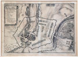
Přerov, On
01.08.1643 (do 31.08.1643)The encampment of the Swedish army is outlined on a place surrounded by trenches near the village of Moszwitz (near Přerov). The river Bečva flows through this place. There is a forest with a small stronghold on the right. The caption A-I and a brief explanatory text are at the top left.
Signature: C. Mardefeldt delineaviit.
Autor: Mardefeldt C., švédský vojenský kartograf
Original name: Abrisz des schwedischen Lägers bei Bröhrau im August 1643.
Katalogová čísla: Collection Český Šternberk, kód: 325/452
When Torstensson with his Swedish army invaded Bohemia from Saxony in April 1643, he did not get the opportunity to fight the Imperial army commanded by Gallas, which was positioned near Brandýs nad Labem. Gallas was not to be provoked to fight a battle, he knew he would undoubtedly lose. Torstensson invaded the area between the army of Gallas in Brandýs and Prague and then he kept marching via Český Brod, Kutná Hora and Litomyšl to Moravia, where he occupied Olomouc and sat his camp near Tovačov and Přerov near the village of Moszwitz. The Swedish army used this encampment as a base for their pillaging attacks in Moravia and the nearby Austrian regions. Gallas was in Bohemia and too weak to carry out an effective counterattack. However, his presence at least prevented the Swedish pillaging Bohemia. The Swedish remained in their field encampment in Tovačov till September 1643, when they unexpectedly withdrew to the north across Silesia up to the Baltic coast. The reason of this unexpected withdrawal of the Swedish army from Moravia was a war that broke out between Sweden and Denmark.
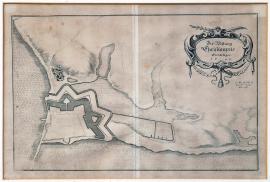
Christianpris, On
01.10.1643 (do 31.12.1643)The plan of the fortress is only sketched with the sea visible on the left. The brief above-mentioned inscription is in an oval cartouche in the right top corner.
Signature: C. Mardefeldt Generalquart. meister delineavit.
Autor: Mardefeldt C., švédský vojenský kartograf
Original name: Der Vestung Christianpris Grundlager 1643.
Katalogová čísla: Collection Český Šternberk, kód: 328/440
Kristianpris is a Danish fortress that withstood the Swedish attacks during the occupation of the Denmark territory by the army of General Torstensson in 1643-1644. As soon as the Swedish-Danish war broke out, Torstensson marched up without any delay with his army from Moravia, followed in a certain distance by the Imperial forces commanded by Gallas, who got as far as the Schleswig-Holstein territory, however, could not seriously threaten the Swedish. Soon enough the Danish were pushed to defensive.
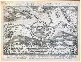
Tuttlingen, On
24.11.1643The river Danube flows across the depicted landscape with the town of Tutlingen above it. Forested and mountainous landscape surrounds the town. There is a mountain pass with the Imperial army standing nearby in regular formations. Another army formation is higher to the right. The German explanatory text is above the picture. The caption A-Q is below it.
Signature: Not available
Autor: Unknown
Original name: Eigentliche Delineation welcher Gestalt, die französisch-weimarsche Armee bey und in Tutlingen im Donauthal von der conjugierten Reichsarmada unter comando Ihr. Excel. Herrn Graffen von Hatzfeld umbringt und gäntzlich ruiniert worden den 14. / 24. November 1643.
Katalogová čísla: Collection Český Šternberk, kód: 326/254
France gradually started to play a large role in the last years of the Thirty Years’ War with its political and military affairs mostly decided by Mazarin, Condé and Turenne. As soon as the French-Swedish army, allied with the troops of some German Protestant princes and commanded by Guebriant, defeated the army of the Elector Archbishop of Cologne in the Battle of the Kempen’s Field in 1642, France started to get on the top bringing the main centre of the fights westwards. However, not much later the French suffered a serious loss when their excellent General Count Guebriant was mortally wounded during the siege of Rothweil. Soon after, the French-Weimar army encamped in the mountainous terrain near Tutlingen above the Danube accessible only by one pass, a place, they considered impossible to be attacked by the Imperial-Bavarian troops. Moreover, it was very cold winter weather. Yet, despite this, General Hatzfeld acting upon the initiative of John of Werth led an unexpected attack on the French-Weimar troops, defeating and shattering them completely in several places, mainly near Tutlingen and Möringen. Only the cavalry had a chance to escape. A total of 7000 soldiers of the French-Weimar army were captured, including 6 generals, 8 colonels and 11 various high officers. At the same time the French also lost the town of Rothweil.
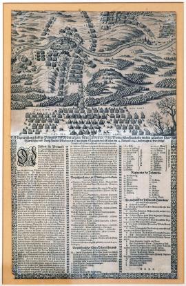
Deutlingen, On
24.11.1643This print depicts the town of Deutlingen above the Danube with its surrounding and the villages of Meringen and Müllen. A forest and the said pass with the position of the Imperial-Bavarian army lies in the foreground. The troops are also spread around the wide surroundings. There are two impressively drawn trees in the right foreground. Below the picture is an extensive German text: 1. A description of the depicted event. 2. A list of killed and captured enemies and the loot. 3. Ordre de bataille of the Imperial-Bavarian army, 4. The caption A-T
Signature: Not available
Autor: Unknown
Original name: Eygentliche wahrhafftige Delineation und Abcontrafactur desz jenigen überfals, so den Weymarischen Frantzosen von den gesambten Churbayrischen und Kays. Reichsvölkern bey Deutlingen, Meringen und Müllen den 24. November 1643 widerfahren, wie selbige Armada auffs Haupt geschlagen und zertrennet worden.
Katalogová čísla: Collection Český Šternberk, kód: 327/264
France gradually started to play a large role in the last years of the Thirty Years’ War with its political and military affairs mostly decided by Mazarin, Condé and Turenne. As soon as the French-Swedish army, allied with the troops of some German Protestant princes and commanded by Guebriant, defeated the army of the Elector Archbishop of Cologne in the Battle of the Kempen’s Field in 1642, France started to get on the top bringing the main centre of the fights westwards. However, not much later the French suffered a serious loss when their excellent General Count Guebriant was mortally wounded during the siege of Rothweil. Soon after, the French-Weimar army encamped in the mountainous terrain near Tutlingen above the Danube accessible only by one pass, a place, they considered impossible to be attacked by the Imperial-Bavarian troops. Moreover, it was very cold winter weather. Yet, despite this, General Hatzfeld acting upon the initiative of John of Werth led an unexpected attack on the French-Weimar troops, defeating and shattering them completely in several places, mainly near Tutlingen and Möringen. Only the cavalry had a chance to escape. A total of 7000 soldiers of the French-Weimar army were captured, including 6 generals, 8 colonels and 11 various high officers. At the same time the French also lost the town of Rothweil.
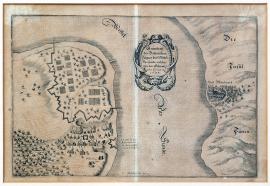
Middelfart, On
01.01.1644 (do 15.01.1644)The picture is divided by the sea strait of Mittelvarsundt, on which is placed the above-stated inscription in an oval ornamental cartouche. The town of Mittelvart (Middelfart) lies the island of Fünen on the right. The Danish encampment is opposite the town. It is under Swedish attack.
Signature: C. Mardefeldt delin.
Autor: Mardefeldt C., švédský vojenský kartograf
Original name: Grundrisz des Dähnischen Lagers bey Mittelvarsundt, welches von den Schwedischen erobert A. 1644.
Katalogová čísla: Collection Český Šternberk, kód: 330/354
The northeast Bohemia and large areas of Moravia were occupied by the Swedish commanded by Torstensson in 1643. It was opposed by a relatively weaker Imperial army led by Matthias Gallas. Gallas was well aware of the numerical superiority of the Swedish army and therefore skilfully avoided a direct battle, in which his army would undoubtedly be defeated. The relations between Sweden and Denmark inflamed at this time, resulting in an open war between the two countries. Torstensson received an order to march against Denmark. He managed to withdraw from the Czech Kingdom crossing the entire Germany and marching right up to the Baltic sea with great mastery not allowing Gallas to intervene seriously in any way. Torstensson used a trick, spreading misleading information about his movements. Moreover, the Swedish troops positioned in Silesia and led by Königsmark kept Gallas busy to such extent that the main Swedish army was able to attack Denmark with full force in a very short time. Only upon arriving at Havelberg did Torstensson inform his army about the orders of the Queen Kristina to fight the Danish. His soldiers followed this order joyfully and the campaign against Denmark commenced straightaway. The depicted event near Mittelvarsundt took place at this time.
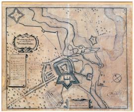
Bremerföhren, On
01.01.1644 (do 15.01.1644)This is a plan of a fortress situated on the river called,Ost-Fluss’. There is a village east of the fortress marked as,ruiniert’ and a swampy territory (Morast) in the northwest. The brief above-stated inscription is in an oval cartouche; the caption A-G is placed on an ornamental ribbon banner. There is scale with an orienteering compass in a square banner at the bottom.
Signature: C. Mardefeldt delin.
Autor: Mardefeldt C., švédský vojenský kartograf
Original name: Geometrischer Grundrisz des Hauses Bremerföhren.
Katalogová čísla: Collection Český Šternberk, kód: 331/405
The print does not state any date or more precise factual information and it is therefore very difficult to determine the historical context of the depicted topic. We can only guess according to the dislocation and the author of the print. Bremervörde is a town situated half-way between Hamburg and Bremen. C. Mardefeldt was a Swedish cartographer, who produced works only during the last years of the Thirty Years’ War. Based on these facts we may deduct that a battle was fought near Bremervörde at the time of the Torstensson’s campaign to Denmark in 1644, after Sweden declared war on the country.
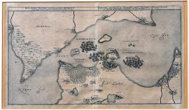
Öresund, On
01.01.1644 (do 31.12.1644)The picture depicts the strait (channel) between the island of Seeland and the Swedish mainland. In the centre of the island lies the city of Copenhagen. The three stated fleets are on the see. There is an inscription on the left:,Nord See’ and on the right:,Ost See’. The German-Latin explanatory text is above the picture.
Signature: Not available
Autor: Unknown
Original name: Eigentliche Delineation des Brumpten Passes Ors Sund in Denemarkh sampt der königl. Schwedischen Denischen und Holändischen Flota A. 1644.
Katalogová čísla: Collection Český Šternberk, kód: 342/85
The Danish King Christian IV led a war against the Swedish in 1643/1644. Sweden was supported by the Netherlands and the Danish resistance was completely broken within a relatively short time (approximately 1 year). Denmark was forced to give Sweden its domains Jemtland and Hërjedalen, and the islands Gotland and Oesel. The engraving depicts the position of the enemy fleets, the Swedish-Dutch and the Danish in the Ore Sund strait between the Swedish mainland and the Danish island of Sjaelland.
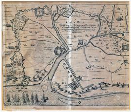
Gravelines, On
01.05.1644 (do 30.06.1644)The print depicts the area around the town of Grevelingen in Flanders. There is a French fleet anchored on the sea unloading the supplies for the besieging army. Nearby is a path to Dunkirk. Trenches of the conquerors are widely circling the town. There are cows, cavalrymen, army regiments and several fortified strongholds all around the countryside. The Flanders coat-of-arms with a lion is above the picture.
Signature: Not available
Autor: Unknown
Original name: Abbildung der Belägerung Grevelingen in Flandern wie selbige von I. Hoheit dem Herttzogen von Orleans im Monat Majo angefangen und gegen Ausgang desz July dieses 1644 Jahrs glücklich vollführt worden.
Katalogová čísla: Collection Český Šternberk, kód: 333/287
This is an episode from the French-Spanish war on the battlefield in Flanders. The French troops, commanded by Duke of Orleans, besieged and conquered the town of Grevelingen, which was held by the troops of the Spanish Netherlands. The picture depicts the French supplies delivery via the sea. Grevelingen is situated nearby Dunkirk and it was conquered by the French in the mid-1644.
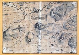
Hohentwiel, On
01.06.1644 (do 30.06.1644)The fortress of Hohentwiel sits atop a high hill in the centre of the picture and is surrounded by a wide belt of fortifications and other constructions. Several villages and the river Aach are visible in the forested landscape.
Signature: Not available
Autor: Unknown
Original name: Die Vestung Hochentwiel sampt derselbigen angestellten Ploquierung des Jahrs 1644 im Junio.
Katalogová čísla: Collection Český Šternberk, kód: 332/478
After the defeat of the French army near Tuttlingen in mid-November 1643, the French Chancellor Mazarin tried to restore the French military reputation as soon as possible. He sent General Turenne with 16000 men to Germany. The army crossed the Rhine and marched against the Bavarian troops that were situated around the fortress of Hohentwiel. However, the Bavarian forces operated skilfully to such extent that Turenne was forced to cross the Rhine back and withdrew to Alsace. Afterwards the Bavarian army split up. One part besieged the Hohentwiel fortress (as depicted on this engraving), while the second part went away to besiege the town of Freiburg. Hohentwiel is situated approximately 30 km northwest of Lake Constance.
Gent, On
28.07.1644 (do 06.09.1644)This is a map of Gent and its surroundings, mostly flooded by water. The dry territory is divided into regular squares, possibly by the dams. The town is surrounded by fortification constructions of the conquerors. A minor episode of a clash between the cavalries is delicately and masterfully drawn at the bottom right. The usual German explanatory text is above the picture.
Signature: Not available
Autor: Unknown
Original name: Des Sasz von Gendt belagerrt den 28. July 1644 durch Ihr. Excel. Friedrich Heinrich von Nassau Printz von Oranien und durch Accord erobert den 6. Sept. dieses Jahrs.
Katalogová čísla: Collection Český Šternberk, kód: 334/288
The states-general of the Netherlands led a lengthy existential fight with Spain. Following the end of the twelve-year truce in 1621, signed in 1609, the fights broke out again, first under the command of Duke Moritz of Orange and after his death in 1625 led by his brother Frederick Henry of Orange. Frederick was a far-sighted statesman and an able commander, the person behind the army successes and the economic boost of the country. The economic growth of the Netherlands during the long war was due to the country being the financial and commercial mediator of almost all of the then world, with unusually rich domains overseas (East-India Company). The town of Gent, occupied by the Spanish, was conquered under the command of Frederick Henry of Orange on 6 September 1644. The described copper engraving depicts this battle.
Freiburg im Breisgau, On
03.08.1644 (do 05.08.1644)This engraving shows the panorama of the surroundings of the city of Freiburg im Breisgau situated above a small river. The army formations are positioned in the forested mountainous terrain. Depicted are also some small clashes with inscribed brief notes. A deep forest lies in the foreground. The above-stated inscription and the caption A-M are placed above the picture.
Signature: Not available
Autor: Unknown
Original name: Abrisz der Statt Freijburg, wie solche in die sechs Wochen ernstlich von den Chur. Bayrischen ist belägert und eingenommen worden acuh der blutigen Scharmützel so sich nach Uibergab der Statt zwischen der königl. französischen und Chur-Bayrischen Armee zugetragen Anno 1644 im Brach und Hewmonat.
Katalogová čísla: Collection Český Šternberk, kód: 335/370
Following the Battle of Tutlingen upon the incentive of the Chancellor Mazarin, the French gathered a strong army on the upper stream of the Rhine in 1644 under the command of generals Turenne and the famed Condé. However, even they could not prevent the Bavarian troops under Mercy conquering Freiburg. The French moved on forcing Mercy to fight them in a battle near Freiburg. The battle was fought from 3 to 5 August 1644 and from the military point of view was one of the most remarkable battles of the Thirty Years’ War. It was full of changes of the tactical disposition on both sides and corresponding counter-tactics of the opponents. Some of the best strategists of the times were standing against each other in this battle. In the end the French were defeated; however both sides suffered great losses. Despite being the winners, the Bavarian troops had to withdraw to Neckarsulm allowing thus the French marching downstream the Rhine. At this occasion the French occupied the towns on the mid-stream of the Rhine: Spezer, Worms, Mannheim, as well as Philippsburg, a fortress famed for being unconquerable. They besieged the fortress on 20 August and conquered it on 9 September 1644 as the garrison lacked men, food and ammunition. Mercy stood near Neckarsulm, too weak and unable to help the besieged Philippsburg and waiting for the reinforcements from the Imperial army commanded by General Hatzfeld. However, before the expected help could come, the key position, the Philippsburg fortress, fell into the hands of the French. Thus the French gained much more from the overall situation than the General Mercy who won the Battle of Freiburg.
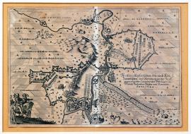
Bernburg, On
01.09.1644 (do 30.11.1644)The engraving depicts the situation along the river Saale with the town of Bernburg. The stream of Saale divides the area of the picture into two same parts. The field encampments of the two enemies lie along both banks of the river. There is a minor scene with three cavalrymen and one infantry soldier in the left foreground. The rest of the depicted landscape is divided into symmetrical quadrangles; the engraver sketched put a tree into each of them. The above-mentioned German text is placed on the right side of the engraving.
Signature: Not available
Autor: Maesbergh C. W. mědirytec
Original name: Abriss der kayserlichen wie auch königl. schwedischen bey Bernburg an der Saal gegen einander campierenden Feld-läger im Monat September, Oktober, November Anno 1644.
Katalogová čísla: Collection Český Šternberk, kód: 340/443
While pursuing Torstensson’s army in 1644, Gallas led the Imperial army as far as the Baltic sea, where he seized the city of Kiel. At this time Torstensson, who hastily marched from Moravia, occupied the entire Denmark, as Sweden declared war on this country in 1643. The Swedish then gathered their armies near Rensburg and Torstensson intended to use this position to initiate a battle with Gallas. However, Gallas avoided the Swedish army and moved across the river Elbe to Magdeburg. Then he had to encamp with the Imperial army in Bernburg above the river Saale, because Torstensson’s strategic manoeuvres cut off his intended way southwards to Bohemia. The Swedish encamped on the other side of the Saale near Bernburg, so both armies faced each other separated only by the river. Gallas later withdrew and invaded Magdeburg. However, the Swedish army surrounded his troops preventing any counteractions. Soon enough Gallas’ army ran out of food. Great starvation forced the men to eat dogs, cats etc. Many of them were in a very miserable shape and tried to defect to the Swedish, however were rejected and sat free. The remaining troops including Gallas himself withdrew to Magdeburg without any supplies or cannons and only later they managed to fight their way to Bohemia. Only one stronger group tried to break free earlier with devastating result. Out of its 4000 cavalrymen only several hundred survived the fight with the Swedish near the town of Jüterborg. Swedish captured 3500 horses. In the end only 2000 men, a mere fraction of the original Imperial army of 12000, returned to Bohemia. Gallas was stripped off his commander rank immediately afterwards.
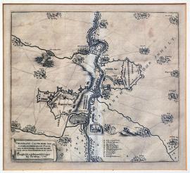
Bernburg, On
01.09.1644 (do 30.09.1644)The river Saale flows across the entire depicted landscape with the town of Bernburg situated southwest of the city of Halle on the Saale. The Swedish camp is on the right bank, while the Imperial army lies on the opposite bank. There are several villages marked with their names in the surroundings. The above-mentioned Latin text is on an unrolled ribbon banner; nearby to the left is the caption A-K. There is an inscription in capital letters across the entire engraving:,Das Fürstenthumb Anhalt’.
Signature: Not available
Autor: Manteau Pierre, francouzský mědirytec
Original name: Delineatio castrorum tam caesareanorum quam suecorum, eorundemque circumvalationis apud Bernburgum MDCXLIV. Kayserisch und schwedisch Läger bey Bernburg 1644.
Katalogová čísla: Collection Český Šternberk, kód: 341/430
While pursuing Torstensson’s army in 1644, Gallas led the Imperial army as far as the Baltic sea, where he seized the city of Kiel. At this time Torstensson, who hastily marched from Moravia, occupied the entire Denmark, as Sweden declared war on this country in 1643. The Swedish then gathered their armies near Rensburg and Torstensson intended to use this position to initiate a battle with Gallas. However, Gallas avoided the Swedish army and moved across the river Elbe to Magdeburg. Then he had to encamp with the Imperial army in Bernburg above the river Saale, because Torstensson’s strategic manoeuvres cut off his intended way southwards to Bohemia. The Swedish encamped on the other side of the Saale near Bernburg, so both armies faced each other separated only by the river. Gallas later withdrew and invaded Magdeburg. However, the Swedish army surrounded his troops preventing any counteractions. Soon enough Gallas’ army ran out of food. Great starvation forced the men to eat dogs, cats etc. Many of them were in a very miserable shape and tried to defect to the Swedish, however were rejected and sat free. The remaining troops including Gallas himself withdrew to Magdeburg without any supplies or cannons and only later they managed to fight their way to Bohemia. Only one stronger group tried to break free earlier with devastating result. Out of its 4000 cavalrymen only several hundred survived the fight with the Swedish near the town of Jüterborg. Swedish captured 3500 horses. In the end only 2000 men, a mere fraction of the original Imperial army of 12000, returned to Bohemia. Gallas was stripped off his commander rank immediately afterwards.
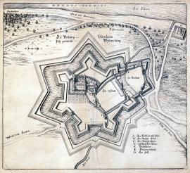
Philippsburg, On
09.09.1644This engraving is rather a schematic plan of the Philippsburg fortress. Only the fortress is depicted in detail while everything else is merely sketched. The river Rhine flows along the top edge of the picture. There are several fishermen houses (Fischerhäuser) along its banks. There is a road between the Rhine and the town leading to Gemersheim. The caption A-G is at the bottom right.
Signature: Not available
Autor: Unknown
Original name: Die Vestung Udenheim jetzt genandt Philipsburg.
Katalogová čísla: Collection Český Šternberk, kód: 336/111
Following the Battle of Tutlingen upon the incentive of the Chancellor Mazarin, the French gathered a strong army on the upper stream of the Rhine in 1644 under the command of generals Turenne and the famed Condé. However, even they could not prevent the Bavarian troops under Mercy conquering Freiburg. The French moved on forcing Mercy to fight them in a battle near Freiburg. The battle was fought from 3 to 5 August 1644 and from the military point of view was one of the most remarkable battles of the Thirty Years’ War. It was full of changes of the tactical disposition on both sides and corresponding counter-tactics of the opponents. Some of the best strategists of the times were standing against each other in this battle. In the end the French were defeated; however both sides suffered great losses. Despite being the winners, the Bavarian troops had to withdraw to Neckarsulm allowing thus the French marching downstream the Rhine. At this occasion the French occupied the towns on the mid-stream of the Rhine: Spezer, Worms, Mannheim, as well as Philippsburg, a fortress famed for being unconquerable. They besieged the fortress on 20 August and conquered it on 9 September 1644 as the garrison lacked men, food and ammunition. Mercy stood near Neckarsulm, too weak and unable to help the besieged Philippsburg and waiting for the reinforcements from the Imperial army commanded by General Hatzfeld. However, before the expected help could come, the key position, the Philippsburg fortress, fell into the hands of the French. Thus the French gained much more from the overall situation than the General Mercy who won the Battle of Freiburg.
Philippsburg, On
09.09.1644Signature: Not available
Autor: Unknown
Original name: Abbildung welcher Gestalt die Vestung Philippsburg von der König. Franzeisischen Armee under dem Commando des Gen. Duc de Anguin ist den 29. August belägert, beschossen und den 9. September 1644 mit Accord erobert worden.
Katalogová čísla: Collection Český Šternberk, kód: 337/366
Following the Battle of Tutlingen upon the incentive of the Chancellor Mazarin, the French gathered a strong army on the upper stream of the Rhine in 1644 under the command of generals Turenne and the famed Condé. However, even they could not prevent the Bavarian troops under Mercy conquering Freiburg. The French moved on forcing Mercy to fight them in a battle near Freiburg. The battle was fought from 3 to 5 August 1644 and from the military point of view was one of the most remarkable battles of the Thirty Years’ War. It was full of changes of the tactical disposition on both sides and corresponding counter-tactics of the opponents. Some of the best strategists of the times were standing against each other in this battle. In the end the French were defeated; however both sides suffered great losses. Despite being the winners, the Bavarian troops had to withdraw to Neckarsulm allowing thus the French marching downstream the Rhine. At this occasion the French occupied the towns on the mid-stream of the Rhine: Spezer, Worms, Mannheim, as well as Philippsburg, a fortress famed for being unconquerable. They besieged the fortress on 20 August and conquered it on 9 September 1644 as the garrison lacked men, food and ammunition. Mercy stood near Neckarsulm, too weak and unable to help the besieged Philippsburg and waiting for the reinforcements from the Imperial army commanded by General Hatzfeld. However, before the expected help could come, the key position, the Philippsburg fortress, fell into the hands of the French. Thus the French gained much more from the overall situation than the General Mercy who won the Battle of Freiburg.
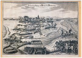
Philippsburg, On
09.09.1644The engraving depicts the town and fortress of Philippsburg surrounded by various defence fortification constructions as well as fortifications of the conquerors and a system of water barriers brought from the nearby Rhine. There are also some swampy areas. The picture clearly shows the way the fortress was protected and fully fortified proving its reputation of being unconquerable. The French conquered it, but only upon agreement due to total lack of food and ammunition of the garrison. A group of cavalrymen with a commander is in the right foreground. The above-stated German explanatory inscription is in the sky over the horizon.
Signature: Not available
Autor: Unknown
Original name: Prospect der Vestung und Belägerung Philippsburg.
Katalogová čísla: Collection Český Šternberk, kód: 338/376
Following the Battle of Tutlingen upon the incentive of the Chancellor Mazarin, the French gathered a strong army on the upper stream of the Rhine in 1644 under the command of generals Turenne and the famed Condé. However, even they could not prevent the Bavarian troops under Mercy conquering Freiburg. The French moved on forcing Mercy to fight them in a battle near Freiburg. The battle was fought from 3 to 5 August 1644 and from the military point of view was one of the most remarkable battles of the Thirty Years’ War. It was full of changes of the tactical disposition on both sides and corresponding counter-tactics of the opponents. Some of the best strategists of the times were standing against each other in this battle. In the end the French were defeated; however both sides suffered great losses. Despite being the winners, the Bavarian troops had to withdraw to Neckarsulm allowing thus the French marching downstream the Rhine. At this occasion the French occupied the towns on the mid-stream of the Rhine: Spezer, Worms, Mannheim, as well as Philippsburg, a fortress famed for being unconquerable. They besieged the fortress on 20 August and conquered it on 9 September 1644 as the garrison lacked men, food and ammunition. Mercy stood near Neckarsulm, too weak and unable to help the besieged Philippsburg and waiting for the reinforcements from the Imperial army commanded by General Hatzfeld. However, before the expected help could come, the key position, the Philippsburg fortress, fell into the hands of the French. Thus the French gained much more from the overall situation than the General Mercy who won the Battle of Freiburg.
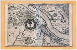
Philippsburg, On
09.09.1644This engraving lacks the usual explanatory text and depicts the Philippsburg fortress on the right bank of the Rhine approximately 20 km south of Speyer. The wide stream of the Rhine divides the painting diagonally. The fortress is surrounded by thick bulwark. There are several small strongholds, villages, water streams and groups of trees in the surrounding landscape along both banks of the Rhine.
Signature: Not available
Autor: Unknown
Original name: Philippsburg
Katalogová čísla: Collection Český Šternberk, kód: 399/150
Following the Battle of Tutlingen upon the incentive of the Chancellor Mazarin, the French gathered a strong army on the upper stream of the Rhine in 1644 under the command of generals Turenne and the famed Condé. However, even they could not prevent the Bavarian troops under Mercy conquering Freiburg. The French moved on forcing Mercy to fight them in a battle near Freiburg. The battle was fought from 3 to 5 August 1644 and from the military point of view was one of the most remarkable battles of the Thirty Years’ War. It was full of changes of the tactical disposition on both sides and corresponding counter-tactics of the opponents. Some of the best strategists of the times were standing against each other in this battle. In the end the French were defeated; however both sides suffered great losses. Despite being the winners, the Bavarian troops had to withdraw to Neckarsulm allowing thus the French marching downstream the Rhine. At this occasion the French occupied the towns on the mid-stream of the Rhine: Spezer, Worms, Mannheim, as well as Philippsburg, a fortress famed for being unconquerable. They besieged the fortress on 20 August and conquered it on 9 September 1644 as the garrison lacked men, food and ammunition. Mercy stood near Neckarsulm, too weak and unable to help the besieged Philippsburg and waiting for the reinforcements from the Imperial army commanded by General Hatzfeld. However, before the expected help could come, the key position, the Philippsburg fortress, fell into the hands of the French. Thus the French gained much more from the overall situation than the General Mercy who won the Battle of Freiburg.
Rendsburg, On
01.01.1645 (do 15.01.1645)There is an inscription,Die Eyder Fluss’ on the right side and,Die Bawer See’ on the left side of the engraving. The town of Rensburg is in the centre, surrounded by trenches and fortifications. An inscription,Des Feindes Läger’ is on the top right and the caption A-CC on the bottom right. The brief above-mentioned text is placed in an ornamental square banner also on the left side of the engraving.
Signature: C. Mardefeldt delineavit.
Autor: Mardefeldt C., švédský vojenský kartograf
Original name: Plan der Statt Rensburg sampt der Belagerung 1645.
Katalogová čísla: Collection Český Šternberk, kód: 343/432
After the Swedish victorious campaign against the Danish in 1643/44, Torstensson gathered his forces in an operative base in Rensburg, which he used for military actions against the Imperial army commanded by Gallas, which pursued the Swedish from the Czech Kingdom across the entire Germany as far as Schleswig-Holstein. Torstensson’s strategic operation brought the Swedish army further south to Launeburg. He left a Swedish garrison in Rensburg, which was later besieged by the Danish. The described copper engraving depicts this event. A peace was signed between Sweden and Denmark in Brömsboro in July 1645; the defeated Denmark had to give up some of its territories to the Swedish.
Heldrungen, On
01.01.1645 (do 31.12.1645)The picture shows the Helderungen Chateau situated on a plain with some hills in the background and the river Unstrut spanned by a bridge in the foreground. A banner on the left top shows the look of the chateau before the siege. Opposite to it is the ground-plan of the chateau. The brief explanatory inscription is in an ornamental ribbon in the centre. There is a cross-section of a fortification construction on the bottom left. The caption A-G is aside.
Signature: Not available
Autor: Unknown
Original name: Abbildung des vesten Schlosz Helderungen, wie solches in der Demolierung Anno 1645 ausgesehen.
Katalogová čísla: Collection Český Šternberk, kód: 358/252
Helderungen is situated approximately 80 km west of Leipzig. Many fights took place in this area during the Thirty Years’ War so it is impossible to determine the exact historical topic of this engraving. However, we may assume, according to the date and features of the picture, that it was a side battlefield, where the Swedish occupied and destroyed (,Demolierung’) the Helderungen Chateau, a strongpoint of the Imperial army.
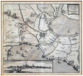
Hulst, On
01.01.1645 (do 31.12.1645)The picture depicts the Hulst fortress surrounded on two sides by water surface. There are various boats sailing on the water. A clash of cavalries is shown at the top left. At the bottom left is an elongated unusual view of Hulst; there are cannons firing from the fortress. The brief inscription, cited word-for-word above, is placed in the top right corner.
Signature: Not available
Autor: Unknown
Original name: Obsidio Hulstenae civitatis et fortality. MDCXLV.“ – Beägerung Hülst. Anno 1645.
Katalogová čísla: Collection Český Šternberk, kód: 359/349
The lengthy war of many years between Spain and the Netherlands was gradually nearing its end. After the long war with France and the Netherlands, Spain was at the end of its strengths. Truce and later peace preparations were under way; they were concluded two years after the event depicted and described on the picture. The siege of Hulst, led by the famous Dutch statesman and commander Frederick Henry of Orange, was one of the last battles between the two countries. Hulst lies approximately 25 km west of Antwerp.
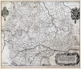
On
14.02.1645 (do 19.12.1648)This is a large map of the Central and Southwest Germany including Bohemia and part of Austria. At the top left and right are coats-of-arms, one of them Swedish. There is an ornamental square cartouche with the above-stated explanatory text at the bottom right. There is a long dotted line – the route of the Swedish army starting in Kadaň on 14 February 1645 and ending in Schweinfurt on 19 December 1648. There are a lot of numbers in several places along the line, which probably mark the number of encampments in the order they were sat up. We are mainly interested into the first part of the journey across our homeland, leading from Kadaň via Dobřany, Klatovy, Horažďovice and Sedlčany to Jankov, the place of the well-known battle (see pages 274-275). After the victory near Jankov, Torstensson marched to Moravia and the Lower Austria. However, he soon returned as the Imperial army gradually recovered from the big defeat and started to threaten the advanced Swedish troops. Torstensson handed the command of the army to Arwed Wittenberg in Litoměřice and later on it was definitely taken over by K. G. Wrangel, who led the troops back to the South Germany. The Swedish appeared in Bohemia once again in 1647, however only managing to conquer the town of Cheb. In 1648 the Czech lands became the centre point of the fights, when the Swedish commanded by Königsmark reconquered Cheb, marched eastwards and invaded Prague conquering the quarters Hradčany and Malá Strana.
Signature: G. W. Kleinsträtl Gen. Quart. M. Leut. delin.
Autor: Kleinsträtl G. W., Generalquartiermeister, vojenský kartograf
Original name: Eigentliche Verzeichnusz des Marsches, welche die königlich schwedische Hauptarmee unter Sr. Excellenz des Herrn Feldmarschallen Leonhart Torstensonuns S. Excellenz des Herrn Feldmarschallen Karl Gustav Wrangeln Commando seithero den 14. February Anno 1645 von Caden ausz bisz nachher Schweinfurt den 19. Dezembris A. 1648 gethan.
Katalogová čísla: Collection Český Šternberk, kód: 349/248
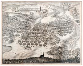
Jankov, On
06.03.1645This picture depicts the beginning of the Battle of Jankov. The above-mentioned inscription is placed on an unrolled ribbon banner at the top left. Large fights and the escape of the Imperial army are depicted in the centre. Several villages in the surroundings are on fire. There is a small chapel in the foreground. It is possibly the chapel, which Götz was supposed to occupy with his troop in order to conquer a strategically important hill. However, Götz lost his way and failed to carry out this task. Allegedly this was the reason for the Imperial army being completely defeated in the battle.
Signature: Not available
Autor: Unknown
Original name: Praelium apud Jancou manet ante Meridiem. Das ersteTreffen bey Jancowitz so sich morgens vor Mittag zugetragen, den 24. Feber, 6. Märt. 1645.
Katalogová čísla: Collection Český Šternberk, kód: 344/239
The Swedish Marshall Leonard Torstensson interrupted his first campaign in Bohemia and Moravia in September 1643, when his army was recalled to Denmark to continue the lengthy war with Sweden. The Emperor sent General Gallas, who was also based in Bohemia in 1643, to the Danish border. While Torstensson achieved a quick victory in Denmark, Gallas had no success at all. Rather to the contrary, a long miserable march across the entire Germany decimated his army to such extent that it was no longer able to fight. Torstensson manoeuvred his army skilfully from the Northern Germany right up to the Czech borders. The Swedish invaded the Czech territory via Kadaň and kept marching towards Písek, Mírovice and Tábor. The Imperial army included the troops of General Hatzfeld, recalled hastily from Germany, the troops of General Götz, who just returned from the campaign against Rakoczy in the east and the Bavarian regiments commanded by the excellent Cavalry General John of Werth. These military forces were gathered near Zelená Hora and marched, just as the Swedish, eastwards but more to the north. At the same time a danger arose that the Swedish might unite with Rakoczy, unless they were stopped from moving further to the east. Moreover, the Emperor’s seat, Vienna, was also under a direct threat. Additionally, the Bavarian troops led by the General Werth were under time pressure and Hatzfeld had therefore no other choice than to order an immediate attack on the Swedish army. The battle broke out in the morning of 6 March 1645 nearby the town of Jankov. Right at the beginning Götz leading a strong regiment got lost failing thus to follow the order to occupy a strategic hill with a small chapel. It was the beginning of the defeat of the Imperial army. Götz got killed near the place he was supposed to occupy and the Imperial troops were fought off and forced to withdraw after a fierce fight. Both sides interrupted the fight after noon and both armies, the Swedish as well as the Imperial, started to line up next to each other. Torstensson was seriously ill at that time and almost unable to move, therefore he was carried near the Imperial camp. Assuming the troops in front of him were only a fraction of the enemy’s army he ordered an attack. The battle broke out again. The remains of the Imperial army fought fiercely and relentlessly, however their defeat was unavoidable. Götz was killed and Hatzfeld was captured. Luckily he had several hundred of golden pieces on him. This made the Swedish to think he was one of the highest officers; otherwise they would certainly kill him, for he rejected to give them his rank and name. Apart from the chief commander of the Imperial army Hatzfeld, further 5 Imperial generals, 185 officers and 4118 men were captured. Approximately 4000 men were killed or captured. The Swedish seized 45 battle banners, 26 cannons, all the carriages, ammunition and supplies of the Imperial army. The winners lost only 2000 men.
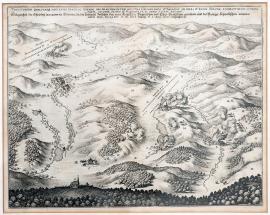
Jankov, On
06.03.1645The engraving depicts a large hilly countryside around the town of Jankov near Votice. Jankov is depicted on the left side of the picture. There is a forest and a church atop a hill in the foreground. Four villages are burning, there are firing artilleries in several places. At the top left near a village marked by the letter,L’ is a battle line-up of the Swedish army. The Latin-German explanatory text is placed above the picture.
Signature: Not available
Autor: Unknown
Original name: Teritorium qualitasque loci apud Jankau Baemiae ubi praeloium inter milites caesariaos et bavaros ab una et regis Sueciae exercitus ab altera parte, 24. febr. st. vet. et 6. marth. st. n. anno 1645 factum.
Gelegenheit des Orts bey Jankow in Böhmen, da die Schlacht zwischen den röm. Kay. Chur. Bayrischen und Chur. Sächsischen an einem und den könihl. Schwedischen armeen anders theils, den 24. Feberst. vet. und 6. Marty St. n. Anno 1645 vorgangen ist.
Katalogová čísla: Collection Český Šternberk, kód: 346/242
The Swedish Marshall Leonard Torstensson interrupted his first campaign in Bohemia and Moravia in September 1643, when his army was recalled to Denmark to continue the lengthy war with Sweden. The Emperor sent General Gallas, who was also based in Bohemia in 1643, to the Danish border. While Torstensson achieved a quick victory in Denmark, Gallas had no success at all. Rather to the contrary, a long miserable march across the entire Germany decimated his army to such extent that it was no longer able to fight. Torstensson manoeuvred his army skilfully from the Northern Germany right up to the Czech borders. The Swedish invaded the Czech territory via Kadaň and kept marching towards Písek, Mírovice and Tábor. The Imperial army included the troops of General Hatzfeld, recalled hastily from Germany, the troops of General Götz, who just returned from the campaign against Rakoczy in the east and the Bavarian regiments commanded by the excellent Cavalry General John of Werth. These military forces were gathered near Zelená Hora and marched, just as the Swedish, eastwards but more to the north. At the same time a danger arose that the Swedish might unite with Rakoczy, unless they were stopped from moving further to the east. Moreover, the Emperor’s seat, Vienna, was also under a direct threat. Additionally, the Bavarian troops led by the General Werth were under time pressure and Hatzfeld had therefore no other choice than to order an immediate attack on the Swedish army. The battle broke out in the morning of 6 March 1645 nearby the town of Jankov. Right at the beginning Götz leading a strong regiment got lost failing thus to follow the order to occupy a strategic hill with a small chapel. It was the beginning of the defeat of the Imperial army. Götz got killed near the place he was supposed to occupy and the Imperial troops were fought off and forced to withdraw after a fierce fight. Both sides interrupted the fight after noon and both armies, the Swedish as well as the Imperial, started to line up next to each other. Torstensson was seriously ill at that time and almost unable to move, therefore he was carried near the Imperial camp. Assuming the troops in front of him were only a fraction of the enemy’s army he ordered an attack. The battle broke out again. The remains of the Imperial army fought fiercely and relentlessly, however their defeat was unavoidable. Götz was killed and Hatzfeld was captured. Luckily he had several hundred of golden pieces on him. This made the Swedish to think he was one of the highest officers; otherwise they would certainly kill him, for he rejected to give them his rank and name. Apart from the chief commander of the Imperial army Hatzfeld, further 5 Imperial generals, 185 officers and 4118 men were captured. Approximately 4000 men were killed or captured. The Swedish seized 45 battle banners, 26 cannons, all the carriages, ammunition and supplies of the Imperial army. The winners lost only 2000 men.
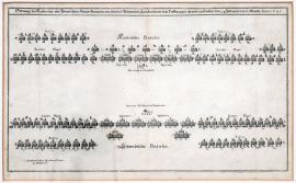
Jankov, On
06.03.1645The engraving depicts schematically the position of the Imperial-Bavarian and Swedish armies. It was typical for the battle plans of the Thirty Years’ War to place the infantry in the centre of the battle formation, with the cavalry squadrons lined-up along both flanks of the army. However, the Swedish army added divisions of forty musketeers amongst the cavalry formations. This tactics was introduced by King Gustav II Adolph and first used in the Battle of Breitenfeld (near Leipzig, 7 September 1631). The cavalry always suffered a lack of firing force, which changed by adding of the musketeers units. Thus the cavalry could rely on the firing support when it was under attack. On the other hand, persistent fire of the musketeers disturbed the enemy’s lines before the attack allowing the cavalry charging with a bigger force. Unfortunately, this engraving does not depict the position of the artillery. The Swedish army introduced some innovation here as well. The cannons no longer stood in one formation during the entire battle. Gustav Adolph II introduced lighter regimental cannons, which were placed into each infantry formation. It was the placement of these lighter cannons, which helped to a large extent to the Swedish victory near Jankov. The Swedish army valued their tactical innovations and was able to fully employ them in battles, such as the Battle of Breitenfeld in 1631 or the Battle of Jankov in 1645.
Signature: Not available
Autor: Unknown
Original name: Ordnung des Kayserlich und Schwedischen Hauptarmaden, wie solche in Böhmen bey Jankowitz vor dem Treffen gegen einander gestanden, den 24. February und 6. Märty Anno 1645.
Katalogová čísla: Collection Český Šternberk, kód: 347/241
The Swedish Marshall Leonard Torstensson interrupted his first campaign in Bohemia and Moravia in September 1643, when his army was recalled to Denmark to continue the lengthy war with Sweden. The Emperor sent General Gallas, who was also based in Bohemia in 1643, to the Danish border. While Torstensson achieved a quick victory in Denmark, Gallas had no success at all. Rather to the contrary, a long miserable march across the entire Germany decimated his army to such extent that it was no longer able to fight. Torstensson manoeuvred his army skilfully from the Northern Germany right up to the Czech borders. The Swedish invaded the Czech territory via Kadaň and kept marching towards Písek, Mírovice and Tábor. The Imperial army included the troops of General Hatzfeld, recalled hastily from Germany, the troops of General Götz, who just returned from the campaign against Rakoczy in the east and the Bavarian regiments commanded by the excellent Cavalry General John of Werth. These military forces were gathered near Zelená Hora and marched, just as the Swedish, eastwards but more to the north. At the same time a danger arose that the Swedish might unite with Rakoczy, unless they were stopped from moving further to the east. Moreover, the Emperor’s seat, Vienna, was also under a direct threat. Additionally, the Bavarian troops led by the General Werth were under time pressure and Hatzfeld had therefore no other choice than to order an immediate attack on the Swedish army. The battle broke out in the morning of 6 March 1645 nearby the town of Jankov. Right at the beginning Götz leading a strong regiment got lost failing thus to follow the order to occupy a strategic hill with a small chapel. It was the beginning of the defeat of the Imperial army. Götz got killed near the place he was supposed to occupy and the Imperial troops were fought off and forced to withdraw after a fierce fight. Both sides interrupted the fight after noon and both armies, the Swedish as well as the Imperial, started to line up next to each other. Torstensson was seriously ill at that time and almost unable to move, therefore he was carried near the Imperial camp. Assuming the troops in front of him were only a fraction of the enemy’s army he ordered an attack. The battle broke out again. The remains of the Imperial army fought fiercely and relentlessly, however their defeat was unavoidable. Götz was killed and Hatzfeld was captured. Luckily he had several hundred of golden pieces on him. This made the Swedish to think he was one of the highest officers; otherwise they would certainly kill him, for he rejected to give them his rank and name. Apart from the chief commander of the Imperial army Hatzfeld, further 5 Imperial generals, 185 officers and 4118 men were captured. Approximately 4000 men were killed or captured. The Swedish seized 45 battle banners, 26 cannons, all the carriages, ammunition and supplies of the Imperial army. The winners lost only 2000 men.
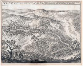
Jankov, On
06.03.1645The picture shows a mountainous and rather deeply forested countryside separated by several small water streams. At the far left is the town of Jankov. A minor scene with two cavalrymen is in the left foreground. One of them is pointing out with his right hand. The battle is taking place on a relatively large area; the Imperial army is clearly withdrawing. There is an engaging scene in the centre of the picture. Two cavalrymen marked by names,Graff von Hatzfeld’ and,Herr Feldmarschall Dorstensohn’ are shaking their hands. We cannot rule out that the author intended to depict the circumstances of Hatzfeld’s capture, although in reality it happened in quite a different way. The Latin explanatory text is placed above the picture.
Signature: Not available
Autor: Unknown
Original name: Secundum et ultimum praelium a Meridie usque ad noctem apud Jankau 24. Feb. 6. Mart. 1645 factum, in quo caesareanos et Bavar. relicto campo Suecis victoriam concedere oportuit.
Katalogová čísla: Collection Český Šternberk, kód: 348/240
The Swedish Marshall Leonard Torstensson interrupted his first campaign in Bohemia and Moravia in September 1643, when his army was recalled to Denmark to continue the lengthy war with Sweden. The Emperor sent General Gallas, who was also based in Bohemia in 1643, to the Danish border. While Torstensson achieved a quick victory in Denmark, Gallas had no success at all. Rather to the contrary, a long miserable march across the entire Germany decimated his army to such extent that it was no longer able to fight. Torstensson manoeuvred his army skilfully from the Northern Germany right up to the Czech borders. The Swedish invaded the Czech territory via Kadaň and kept marching towards Písek, Mírovice and Tábor. The Imperial army included the troops of General Hatzfeld, recalled hastily from Germany, the troops of General Götz, who just returned from the campaign against Rakoczy in the east and the Bavarian regiments commanded by the excellent Cavalry General John of Werth. These military forces were gathered near Zelená Hora and marched, just as the Swedish, eastwards but more to the north. At the same time a danger arose that the Swedish might unite with Rakoczy, unless they were stopped from moving further to the east. Moreover, the Emperor’s seat, Vienna, was also under a direct threat. Additionally, the Bavarian troops led by the General Werth were under time pressure and Hatzfeld had therefore no other choice than to order an immediate attack on the Swedish army. The battle broke out in the morning of 6 March 1645 nearby the town of Jankov. Right at the beginning Götz leading a strong regiment got lost failing thus to follow the order to occupy a strategic hill with a small chapel. It was the beginning of the defeat of the Imperial army. Götz got killed near the place he was supposed to occupy and the Imperial troops were fought off and forced to withdraw after a fierce fight. Both sides interrupted the fight after noon and both armies, the Swedish as well as the Imperial, started to line up next to each other. Torstensson was seriously ill at that time and almost unable to move, therefore he was carried near the Imperial camp. Assuming the troops in front of him were only a fraction of the enemy’s army he ordered an attack. The battle broke out again. The remains of the Imperial army fought fiercely and relentlessly, however their defeat was unavoidable. Götz was killed and Hatzfeld was captured. Luckily he had several hundred of golden pieces on him. This made the Swedish to think he was one of the highest officers; otherwise they would certainly kill him, for he rejected to give them his rank and name. Apart from the chief commander of the Imperial army Hatzfeld, further 5 Imperial generals, 185 officers and 4118 men were captured. Approximately 4000 men were killed or captured. The Swedish seized 45 battle banners, 26 cannons, all the carriages, ammunition and supplies of the Imperial army. The winners lost only 2000 men.
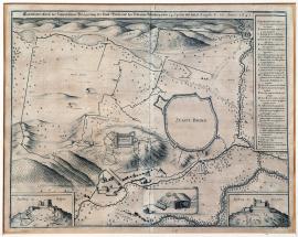
Brno, On
03.05.1645 (do 23.08.1645)This is a map of the surroundings of Brno; the city itself is only schematically sketched without any details. The Špilberk hill with the chateau is at the edge of the city. There are fortification constructions and trenches of the conquerors in various places around the town. The German explanatory text is above the picture; the caption A-X is on the right in a rectangular banner. There are two detailed views of Špilberk in both bottom corners. There is a detailed drawing of the enemy’s trenches between them.
Signature: Not available
Autor: Unknown
Original name: Eigentlicher Abrisz der schwedischen Belägerung der Statt Brinn und des Schlosses Spielberg vom 24. April bisz den 13. Augusti St. vet. Anno 1645.
Katalogová čísla: Collection Český Šternberk, kód: 356/424
The picture does not include any closer historical or factual data. It can be assumed, however, according to the time of its printing, that it depicts the unsuccessful siege of the city carried out by the Swedish under Torstensson from 3 May till 23 August of the Gregorian calendar. The city fought back bravely led by the Imperial General de Souches who efficiently supported the unyielding fight of the garrison as well as citizens. The Swedish invaded the area around Brno after their victory near Jankov. However, strategic reasons forced the Swedish to withdraw from the siege in August 1645. Brno defended itself and was not occupied by the Swedish. The siege of Brno played an important strategic role in the futile Swedish campaign to Vienna. The failed siege decimated the Swedish army to such extent that its main part had to withdraw from Moravia. The Swedish did not carry out any more important military events on our territory until the siege of Prague in 1648.
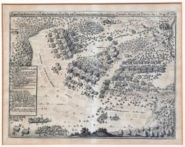
Mergenthal, On
05.05.1645The battle is depicted in three stages. The village of Herbsthausen, which gave the battle its name, is in the centre of the picture. At the top right above the river Tauber is the township of Mergenthal with a deep forest to the left. There are cuirassiers in the left foreground, nearby is a square banner with the caption A-Q. The brief German text explaining the depicted event is above the picture.
Signature: Not available
Autor: Malleual, francouzský kartograf
Original name: Eygentliche Delineation des Treffens zwischen Chur. Bayr. und Franzö. Armee unter Commando deren Generalen Mercy und Tureno den 5. May 1645.
Katalogová čísla: Collection Český Šternberk, kód: 350/418
French General Turenne crossed the Rhine near Philippsburg with his army in the spring 1645, joined the troops led by General Rosen and marched to Württemberg. His opponent, the Bavarian General Mercy, was near Weiblingen observing Turenne, who seemed to be preparing an invasion into Bavaria. However, the French went to the Tauber conquering there some towns, for instance Rothenburg. By skilful strategic manoeuvres Mercy deceived Turenne and appeared out of the blue near Herbsthausen right next to the French army on 5 May 1645. A bloody battle broke out, in which the French were defeated. Nothing was known about Turenne’s destiny for two days and he was thought to be dead. General Rosen, the commander of the Weimar cavalry was captured as were many other officers and approximately 1500 men. Further 50 battle banners, 6 cannons and a large part of the French war cash were seized.
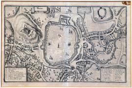
Brno, On
21.06.1645 (do 31.08.1645)This engraving shows a view of the city of Brno. There are churches drawn in the city, nearby are its suburbs and several tiny unnamed rivers. On the left is the Špilberk hill. There is an inscription,Brinn’ is on an ornamental ribbon banner on the far left. Along both sides of the picture are ornamental vignettes with captions A-L and M-5.
Signature: Not available
Autor: Unknown
Original name: Brinn
Katalogová čísla: Collection Český Šternberk, kód: 355/391
The picture does not include any closer historical or factual data. It can be assumed, however, according to the time of its printing, that it depicts the unsuccessful siege of the city carried out by the Swedish under Torstensson from 3 May till 23 August of the Gregorian calendar. The city fought back bravely led by the Imperial General de Souches who efficiently supported the unyielding fight of the garrison as well as citizens. The Swedish invaded the area around Brno after their victory near Jankov. However, strategic reasons forced the Swedish to withdraw from the siege in August 1645. Brno defended itself and was not occupied by the Swedish. The siege of Brno played an important strategic role in the futile Swedish campaign to Vienna. The failed siege decimated the Swedish army to such extent that its main part had to withdraw from Moravia. The Swedish did not carry out any more important military events on our territory until the siege of Prague in 1648.
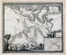
Rottenburg, On
12.07.1645This large engraving of the French origin depicts the city of Rottenburg on the river Tauber and its surroundings. Lined-up army formations are sketched in the depicted landscape. There are deep forests behind the town. There is a scene with two cavalrymen in the left foreground. One of them is pointing ahead with his cord. An ornamental cartouche with allegoric emblems and the above-mentioned French explanatory text are at the top left. A separated banner with a detailed map of the surroundings of Rottenburg is at the bottom right. Above that are more emblems of a military character. The entire print is framed in a decorative engraved frame.
Signature: Par le Sr. de Beaulieu ingenieur du roy, a Paris.
Autor: Beaulieu Sr. de, inženýr, francouzský kartograf z Paříže
Original name: Plan de la ville de Rottenbourg sur le Tauber en Franconie assiégée et prise par les armées du Roy trés chrestien Louis XIV. commandée par monseigneur le duc D´Anguien assisté par les troupes de Madame la Landgrave de Hesse, commandée par le general Geisze le 12. Juilliet 1645.
Katalogová čísla: Collection Český Šternberk, kód: 351/380
Turenne and Condé crossed the Rhine near Philippsburg in March 1645, while General Mercy and the Bavarian army took a position near Weiblingen intending to prevent the French invasion into Bavaria. However, Turenne turned to Hall on the Rocher conquering the city immediately. Mercy was unable to prevent it. After that Mercy assumed that Turenne would turn to the Danube and took his army near Ellwangen. However, Turenne and Condé marched to the river Tauber and seized the city of Rottenburg on 12 July 1645. The described engraving depicts this event.
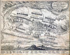
Allerheim, On
03.08.1645In the foreground of this picture lies the Wallerstein castle. The army formations are placed around the entire area of the depicted countryside. A battle is already raving in some places. The river Wörnitz creates frames the print on the left and at the top. There is an ornamental vignette with the above-mentioned Latin-German text at the top right. The extensive topographic and factual caption 1-28 and A-Z is below the picture. It lists the names of all the Bavarians and French regiments that fought in the battle under the letters a-h.
Signature: Not available
Autor: Unknown
Original name: Praecipua cruentaeque illus pugnae inter elect. Bavari et Galliarum regis an 1645 d. 3. Augusti apud Allerheim comiruissae delineatio.
Abbildung des Haupttreffens zwischen den Chur. Bayrischen und französischen Armeen bey Allerheim geschehen den 3. Augusti 1645.
Katalogová čísla: Collection Český Šternberk, kód: 352/40D
As soon as the French army commanded by generals Turenne and Condé crossed the Rhine near Philippsburg in spring 1645, the General Mercy blocked their way with the Bavarian army. Both sides manoeuvred skilfully trying to gain advantageous operative bases. The French occupied the cities Rottenburg on the river Tauber and Hall on the river Rocher and fought the Bavarian army near Herbsthausen on 5 May and near Freiburg later on. They were defeated in both battles though. Both opponents got very close to each other near Allerheim on the river Wörnitz at the beginning of August 1645 and a battle broke out. Generals Mercy, John of Werth and Gleen commanded the Bavarian troops. The Allerheim Chateau was in the area of the left flank of the Bavarian line-up formation. The battle was initiated by a charge of the French infantry and it was an unusually indecisive fight with many crises and twists on both sides. It was a tactical contest of the greatest strategists of the times. After the General Mercy was killed, the French started gaining ground, winning the battle in the end. The defeat of the Bavarian army is assigned to the death of General Mercy, however it was the,La Gran Condé’ who stood behind the French success. General Mercy was one of the best strategists of his times and was irreplaceable. Moreover, the Elector of Bavaria also lost General Gleen, who was captured by the French. The Bavarian army further lost 4000 men, who died on the battlefield, 2000 men were captured and 15 cannons and 40 battle banners and flags were seized. The French lost 4000 men. The Battle of Allerheim took place on 3 August 1645.
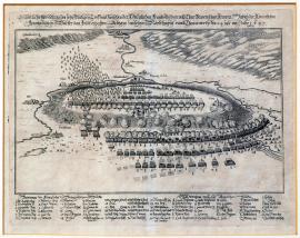
Allerheim, On
03.08.1645This is a picture of a battle that is usually called the,Battle of Allerheim’. There is the formation of the Bavarian army atop a hill in the centre of the painting. Its right flank is withdrawing and starting to flee. The river Wörnitz flows around the said hill. Bellow the hill to the right is the French position. A path leading to Nördlingen is sketched nearby. The German explanatory text is above the picture and the extensive caption 1-42, A-Z and 1-7 is below the picture.
Signature: Not available
Autor: Unknown
Original name: Eigentliche Abbildung des sehr blutigen Treffens zwischen der königlichen französischen und Churbayrischen Armeen wobei die königlichen französischen Völker das Feldt erhalten, geschehen zwischen Nördlingen und Thonawerth den 24. July im Jahr 1645.
Katalogová čísla: Collection Český Šternberk, kód: 353/282
As soon as the French army commanded by generals Turenne and Condé crossed the Rhine near Philippsburg in spring 1645, the General Mercy blocked their way with the Bavarian army. Both sides manoeuvred skilfully trying to gain advantageous operative bases. The French occupied the cities Rottenburg on the river Tauber and Hall on the river Rocher and fought the Bavarian army near Herbsthausen on 5 May and near Freiburg later on. They were defeated in both battles though. Both opponents got very close to each other near Allerheim on the river Wörnitz at the beginning of August 1645 and a battle broke out. Generals Mercy, John of Werth and Gleen commanded the Bavarian troops. The Allerheim Chateau was in the area of the left flank of the Bavarian line-up formation. The battle was initiated by a charge of the French infantry and it was an unusually indecisive fight with many crises and twists on both sides. It was a tactical contest of the greatest strategists of the times. After the General Mercy was killed, the French started gaining ground, winning the battle in the end. The defeat of the Bavarian army is assigned to the death of General Mercy, however it was the,La Gran Condé’ who stood behind the French success. General Mercy was one of the best strategists of his times and was irreplaceable. Moreover, the Elector of Bavaria also lost General Gleen, who was captured by the French. The Bavarian army further lost 4000 men, who died on the battlefield, 2000 men were captured and 15 cannons and 40 battle banners and flags were seized. The French lost 4000 men. The Battle of Allerheim took place on 3 August 1645.
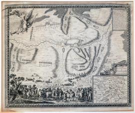
Dinkelsbühl, On
19.08.1645The town of Dinkelsbühl situated in Swabia is depicted in the centre of this large map. It is surrounded by forests, several ponds and streams. The army troops and fortification constructions are dotted in various places of the countryside. A minor scene depicting the meeting of the Duke d’Enghein (the so-called Condé) with the General de Grammont is depicted in the foreground. On the right is a small map of Swabia with an appropriate inscription and a scale. There is a banner in the top right corner with a description of the depicted event. The above-mentioned French text is in an ornamental cartouche on the other side.
Signature: A Paris par le Sr. de Beaulieu Ing. et geograf du Dory.
Autor: Beaulieu Sr. de, inženýr, francouzský kartograf z Paříže
Original name: Plan de la ville de Dinkespuhel en Souabe assiégée par les armées du roy trés crétien Louis XIV. asisté des troupes de Madme la Landgrave de Hesse commandées par Monseigneur le duc Anguien, general des armées de sa Majestée en Allemagne, le 19. Auost 1645 et rednu a l´obeissance du Roy le 26 du dit mois en suivant.
Katalogová čísla: Collection Český Šternberk, kód: 357/393
After the French General Turenne with his army crossed the Rhine near Philippsburg in the spring of 1645, he invaded the area of the river Tauber, conquering the towns Rothenburg and Mergendtheim. However, on 24 April 1645 he unexpectedly faced Mercy near Herbsthausen and suffered a considerable defeat. He no longer was able to carry out any operations and was to wait for the reinforcements, from generals Condé and Grammont. As soon as they arrived with a new French army they returned to the Tauber and occupied Rottenburg on 12 July and Dinkelsbühl on 26 August 1645.
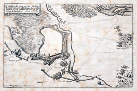
Rain, On
01.01.1646 (do 31.12.1646)This engraving shows prominent white areas. The town of Rain is – as it is common on these engravings – only sketched, while the fortification walls, bulwark and towers are done in great detail. The French and Swedish access trenches and other fortification constructions of the attackers are near the town. At the right edge of the engraving is an inscription ‘Schwed. Hauptquartier’. There is a short section of the river Lech in the top right corner. The brief explanatory text is in the ornamental ribbon banner above the picture.
Signature: Not available
Autor: Kleinsträtl G. W., Generalquartiermeister, vojenský kartograf
Original name: Eigentliche Delineatio der Vestung Rayn, wie solche von Ihr. Excell. Herrn Gen. Veldt. M. Carol Gustav Wrangeln belägert und erobert worden. Anno 1646.“ – G. W. Kleinsträtl G. Quartir M. L. delin.
Katalogová čísla: Collection Český Šternberk, kód: 368/32 D
After difficult negotiations the Swedish troops led by Marshal Wrangel finally joined with the French troops of 5000 men led by General Turenne. The allied army then moved across Swabia towards the west borders of Bavaria intending to conquer Augsburg, move rapidly to the east and invade the Austrian inherited lands. However, the siege of Augsburg took longer than expected. In the end, the Archduke Leopold Wilhelm arrived hastily with the Imperial-Bavarian army to help and managed to free the town from the siege. The only success of the Swedish-French army under the command of Wrangel and Turenne was the conquest of the town of Rain situated in the West Bavaria approximately 35 km north of Augsburg. The described military events took place during the year 1646.
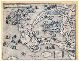
Orbetello, On
01.01.1646 (do 31.12.1646)The engraving depicts the port of the town of Ortebelli situated on the coast of the Mediterranean Sea directly opposite Corsica. There are many fighting battle ships on the sea. Several firing positions of the artillery batteries are on the mainland, firing at the combating fleets. There is a line of six windmills behind the city and an extensive fortification system, army camps and even fighting infantry units. The above brief word-for-word cited Latin text is in an ornamental ribbon banner at the top left. Another similar banner shows the caption A-G.
Signature: Not available
Autor: Unknown
Original name: Circumsessio Ortebelli cum proelio navali inter Hispanos et Gallos. Anno 1646.
Katalogová čísla: Collection Český Šternberk, kód: 369/166
Most of the 17th century witnessed the lengthy war between the slowly decaying medieval world power – Spain and the upcoming dynamic France, which, ruled by the statesmen Richelieu and Mazarin and the kings Louis XIII and Louis XIV was gradually acquiring political and military powers. The war between the French and the Spanish was fought on the Pyrenees borders as well as on the territory of the Spanish Netherlands and in various places in Italy. Moreover, as both countries boasted large and powerful fleets, there were naval battles fought quite far from the homelands of the two countries. The depicted battle was fought on the see and on the Italian mainland in 1646. Italy of the 17th century was a conglomerate of many small and insignificant states that were unable to face the interventions of their powerful neighbours. These world powers (France, Spain and the Holy Roman Empire) occupied Italian territories and acquired dominions over which they consequently and relentlessly fought.
Krems, On
06.05.1646At the bottom of the picture flows the wide river Danube with an island and the town of Krems on its bank. The town is only sketched; its centre is left unfilled. The surrounding countryside is hilly with a zigzagging stream called,Kremswasser’. There is a relatively large square banner with the caption 1-25 and the above-mentioned German explanatory text in the top right corner.
Signature: Franciscus Pironi delin. Elias Wideman sculpsit.
Autor: Wideman Elias, mědirytec
Original name: Grundriss von der Belägerung der Statt Krems und wie dieselbe von dem Herren General Feldzeugmeistern Herrn Grafen von Puchheimb A. 1646 den 6. Mai mit Accord erobert worden ist.
Katalogová čísla: Collection Český Šternberk, kód: 360/89
While the Swedish General Torstensson was besieging Brno (summer months of 1645) the Archduke Leopold Wilhelm, a brother of the Emperor, strengthened up his army and was strong enough to get near the left bank of the Danube, which was under the most pressure by the Swedish army. However, Torstensson realising that the massive river is an unsurpassable obstacle, dropped his plans to enter the Austrian hereditary lands from the north and shaken by a serious illness he returned to Bohemia. He resigned to his rank soon after his return to Litoměřice. The Archduke Leopold Wilhelm ordered the General Count Puchheim to force the Swedish out of their strongpoints on the northern bank of the Danube. The conquest of Krems by the Imperial army on 6 May 1646 was part of this campaign. The Swedish garrison left upon agreement.
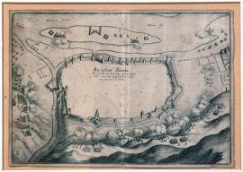
Krems, On
06.05.1646The river Danube with an island flows at the top edge of the copper engraving. The town of Krems is on its left bank. The outline of the town with fortification constructions are done in detail while the centre of the town is unfilled. Near the town is the Krems stream. Artillery batteries firing at the town are situated in the near surroundings of the town. There are ballistic trajectories including the hits or effects of the projectiles on the target drawn meticulously.
Signature: Not available
Autor: Unknown
Original name: Die Statt Crembs wie sie in Früeling des 1646 Jahrs von den Kayserlichen wieder eingenommen worden.
Katalogová čísla: Collection Český Šternberk, kód: 361/453
While the Swedish General Torstensson was besieging Brno (summer months of 1645) the Archduke Leopold Wilhelm, a brother of the Emperor, strengthened up his army and was strong enough to get near the left bank of the Danube, which was under the most pressure by the Swedish army. However, Torstensson realising that the massive river is an unsurpassable obstacle, dropped his plans to enter the Austrian hereditary lands from the north and shaken by a serious illness he returned to Bohemia. He resigned to his rank soon after his return to Litoměřice. The Archduke Leopold Wilhelm ordered the General Count Puchheim to force the Swedish out of their strongpoints on the northern bank of the Danube. The conquest of Krems by the Imperial army on 6 May 1646 was part of this campaign. The Swedish garrison left upon agreement.
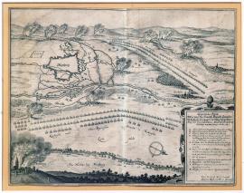
Augsburg, On
13.05.1646This engraving depicts a ground-plan of Augsburg with bulwark and the Swedish attacking constructions. The position of the Imperial-Bavarian army is in the south. There is a burning town of Freiberg to the east above the river Bar. The Swedish-French army is at the top right surrounded by several burning villages. There is a square ornamental cartouche with the German explanatory text and the caption A-Z at the bottom right. There is an orienteering compass at the bottom.
Signature: Carl Friedrich Reich Gen. Quart. meister & Obrist del.
Autor: Reich Carl. Friedrich, Generalquartiermeister u. Obrist, kreslíř obrazů a plánů
Original name: Eigentlicher Abrisz wie von ihr. Hochfürstl. Durchl. Leopold Wilhelm Ertzhertzogen von Ostereich der Röm. Kay. Mt. Gneralissimo etc. die Statt Augspurg entsetzt worden, den 13. Octob. 1646.
Katalogová čísla: Collection Český Šternberk, kód: 364/353
The Archduke Leopold Wilhelm, a brother of the Emperor Frederick III, took over the command of the Imperial army after its defeat in the Battle of Jankov in winter 1645. Following lengthy and difficult negotiations, the Marshal Wrangler finally joined his Swedish army with the French forces and the together two allies crossed the Rhine and headed eastwards to invade the Austrian hereditary lands. This eastern campaign was interrupted by a relatively long besiege of Augsburg, which garrison fought back relentlessly. Archduke Leopold, who was marching against the Swedish-French attack, suddenly appeared with his troops on 13 October 1646 at the surrounded Augsburg and freed it from the enemy’s siege.
On
31.05.1646This copper engraving depicts the stated visions and several other unusual phenomenons in the sky. The extensive explanatory text, cited word-for-word on the previous page is above the picture. Another four-stanza German text is below the picture. In detail it describes and explains the magical signs sent by the God, to alert and urge the faithful ones that there was enough of the unrestrained war craziness and it is necessary to lead a moral life to reinstall the peace.
Signature: Gedruckt zu Cöllen bey Peter Brachel, im Jahre Christi 1646.
Autor: Brachel Peter, tiskař v Kolíně n. Rýnem
Original name: Zwey wahrhaffeige und erschröckliche Gesicht und Wunderzeichen hat uns Gott für Augen gestellt an unterschiedlichen Orthen im Graven-Hage in diesem 1646 Jahr, Sonntags den 31. May, nach Mittags umb halb ein Uhr am hellen und klaren Himmel, seine Gestalt werdet ihr ausz dieser Figur und Gesang vernemen. Im Thon: Der grimmig Todt mit seinem Pfeil, etc.
Das ander: Wie in Kärnten bey Rockelsburg, Ludenberg und deren Orten, am H. Palm-Sonntag zu Mittag, fünf Sonnen, ein Todtenbahr, zween Regenbogen creutzweisz über sich gekehrt und ein feurige Ruth hat sehen lassen. Im Thon: Wann mein Stündlein vorhanden ist etc.
Katalogová čísla: Collection Český Šternberk, kód: 362/120
The topic of this leaflet is characteristic for the mentality of the people of the 17th century. Various unusual natural phenomenons (for instance the Northern Lights, comets, fireballs etc.) were perceived as supernatural magical signs sent by the God who was thus reprimanding the human kind of the necessity to improve their ways. Obviously such phenomenons were fantastically refined according to the needs. The majority of people inclined strongly to superstitions so news like this always found enough audience.
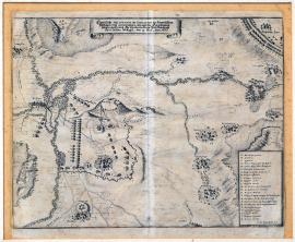
Amöneburg, On
19.06.1646This delicate engraving depicts in much detail the situation around the town of Amöneburg in Hesse. The town atop a hill is only schematically sketched. There are many villages and settlements marked by their names in the surroundings and also several army camps and lined-up troops. The Imperial encampment is at the top right of the print. The German explanatory text is on an unrolled ornamental ribbon banner the top. The caption A-Z is in a rectangular banner at the bottom left.
Signature: G. W. Kleinstratl. fecit.
Autor: Kleinsträtl G. W., Generalquartiermeister, vojenský kartograf
Original name: Eigentliche Delineation der Situation des Schwedischen Veldtlägers bey Amönenburg, wie auch die Einnehmung selbigen Orts durch Ihr. Excellenz Herrn Feldmarschallen Carol Gustau Wrangeln den 19. Juny 1646.
Katalogová čísla: Collection Český Šternberk, kód: 363/428
As soon as the French troops led by Turenne joined the Swedish army commanded by Wrangel, both armies marched to Bavaria to invade the Austrian hereditary lands, despite the complications caused by serious differences in opinions of both commanders. During this campaign the Swedish troops led by Wrangel arrived near the town of Amöneburg situated on the river Werra in Hesse. The Swedish managed to conquer the town despite the Imperial army being in the near vicinity on 16 June 1646. The described cooper engraving depicts this event.
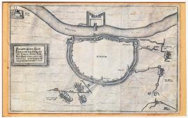
Höxter, On
01.07.1646 (do 31.12.1646)This is a schematic drawing of the town of Höxter. The outline of the town and the fortifications are done in a great detail while the centre of the town is unfilled. The Swedish attacking fortifications and trenches are around the town in a wide circle. The river Weser is at the top with fortifications on its other bank. Nearby to the left is the Corvey Monastery. There is also a square banner on this side of the picture with the above-mentioned inscription.
Signature: Not available
Autor: Unknown
Original name: Grundrisz der Statt Höxter und wie selbige von Ihr. Excellenz Herrn Feldmarschallen Carol Gustav Wrangel bezwungen und eingenommen worden. 1646.
Katalogová čísla: Collection Český Šternberk, kód: 365/357
The Archduke Leopold Wilhelm reinforced his army in 1646 to such extent that he managed to force the Swedish commander Marshal Wrangel to withdraw from Bohemia with his forces. At the same time the Elector of Saxon signed a truce with the Swedish, which made large territories at the rear of the army safe for the Swedish. Therefore Wrangel decided to march northwards. However, the Imperial army was also reinforced by the Bavarian troops and was also moving slowly to the north. Wrangel marched to the Weser occupying the towns Höxter, Paderborn, Stattbergen and Wetzlar, conquering almost the entire Westphalia and Upper Hesse in a relatively short time. Afterwards he tried to ally with the French led by the General Turenne to even up the forces with the Imperial-Bavarian army commanded by the Archduke Leopold Wilhelm, which threatened him from the south. The mentioned towns were conquered by the Swedish in the second half of 1646.
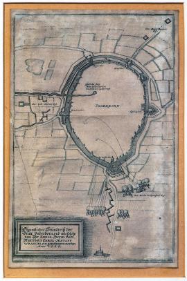
Paderborn, On
01.07.1646 (do 31.12.1646)This letter-sized picture shows a schematic ground-plan of the town of Paderborn in Westphalia. Only the fortification walls and towers are done in detail. There are four Swedish firing batteries outside the town. There is a small church drawn at the very bottom. Next to it is a square banner with the above-mentioned German explanatory text. There is an interesting well in the centre of the town, which gave the town its name,Paderborn’ (born = spring).
Signature: Not available
Autor: Unknown
Original name: Eigentlicher Grundrisz der Statt Paderborn und wie solche von Ihr. Excel. Herrn Veltmarschallen Carol Gustaff Wrangel eingenohmen worden. Anno 1646.
Katalogová čísla: Collection Český Šternberk, kód: 366/388
The Archduke Leopold Wilhelm reinforced his army in 1646 to such extent that he managed to force the Swedish commander Marshal Wrangel to withdraw from Bohemia with his forces. At the same time the Elector of Saxon signed a truce with the Swedish, which made large territories at the rear of the army safe for the Swedish. Therefore Wrangel decided to march northwards. However, the Imperial army was also reinforced by the Bavarian troops and was also moving slowly to the north. Wrangel marched to the Weser occupying the towns Höxter, Paderborn, Stattbergen and Wetzlar, conquering almost the entire Westphalia and Upper Hesse in a relatively short time. Afterwards he tried to ally with the French led by the General Turenne to even up the forces with the Imperial-Bavarian army commanded by the Archduke Leopold Wilhelm, which threatened him from the south. The mentioned towns were conquered by the Swedish in the second half of 1646.
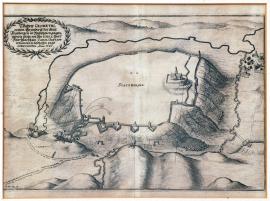
Stadtbergen, On
01.07.1646 (do 31.12.1646)The town is schematically outlined atop a hill with a river flowing around it. Only a church and several fortification constructions are drawn in detail inside the town. There is a small unnamed village nearby. The Swedish artillery and mortar batteries are firing from four firing positions at the town. There is an oval banner lined with a Lauer wreath with the above-mentioned inscription in the top left corner.
Signature: Not available
Autor: Unknown
Original name: Wahrer geometrischer Grundrisz der Statt Stattbergen in Westphalen gelegen und wie solche von Ihr. Excellenz Herrn Feldmarschallen Carol Gustaff Wrangeln beschossen und erobert worden. Anno 1646.
Katalogová čísla: Collection Český Šternberk, kód: 367/386
The Archduke Leopold Wilhelm reinforced his army in 1646 to such extent that he managed to force the Swedish commander Marshal Wrangel to withdraw from Bohemia with his forces. At the same time the Elector of Saxon signed a truce with the Swedish, which made large territories at the rear of the army safe for the Swedish. Therefore Wrangel decided to march northwards. However, the Imperial army was also reinforced by the Bavarian troops and was also moving slowly to the north. Wrangel marched to the Weser occupying the towns Höxter, Paderborn, Stattbergen and Wetzlar, conquering almost the entire Westphalia and Upper Hesse in a relatively short time. Afterwards he tried to ally with the French led by the General Turenne to even up the forces with the Imperial-Bavarian army commanded by the Archduke Leopold Wilhelm, which threatened him from the south. The mentioned towns were conquered by the Swedish in the second half of 1646.
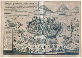
Weißensberg, On
03.01.1647 (do 23.01.1647)This engraving depicts a fortified town surrounded by the besieging army firing from many artillery batteries. There are two cavalrymen, three infantrymen and a small dog in the right foreground. At the top left is a square banner with the above-mentioned inscription. The caption A-N is below the picture.
Signature: Not available
Autor: Unknown
Original name: Eigentliche Abbildung der von Kays. und Churbayr. Herren Generalen und dero bey sich habenden Commandierten Völkern beider Armee plockiert, beschossen und entliche mit Accord übergebenen Statt Weissenburg im Norgau vom 3. bis 23. Januarii Anno 1647.
Katalogová čísla: Collection Český Šternberk, kód: 371/411
The engraving depicts one of the last war episodes in Bavaria, fought just before a truce signed between the Elector Maximillian of Bavaria and the Swedish and French forces in Ulm in March 1647. Weissenburg lies approximately 30 km south of Nuremberg. As soon as the Swedish occupied Weissenburg, they marched to Lake Constance leaving only a small garrison in the seized town. Meanwhile the Imperial army moved to Bohemia. The Duke Maximillian of Bavaria was forced to sign the truce with the enemy as his country was completely exhausted by the war. However soon enough, in the autumn of the same year, Bavaria returned to the war.
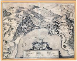
Bregenz, On
05.01.1647There is Lake Constance in the bottom part of the depicted landscape, surrounded by mountainous terrain with the town of Bregenz and its chateau atop a high hill. Charging army troops are situated in various places on the hilltops in the countryside near the town. In the bottom centre is an ornamental cartouche with the above-mentioned German explanatory text and the caption A-X. Above the described cartouche is the coat-of-arms of Bregenz.
Signature: Georg Wilhelm Kleinsträttl Gen. Quart. Meist. Leutnant.
Autor: Kleinsträtl G. W., Generalquartiermeister, vojenský kartograf
Original name: Abbildung der Statt Bregentz wie dieselbe von Ihr. Excell. dem Herrn Veldtmarschallen Carl Gustau Wrangel den 5. Jan. 1647 mit sturmb eingenohmen worden.
Katalogová čísla: Collection Český Šternberk, kód: 370/105
The sites of the most important battles of 1646 moved from Bohemia and continued across the area around the river Weser to Westphalia. The fights then continued to Hesse and along the rivers Mohan, Danube, Lech and Isar up to the banks of Lake Constance, where Marshal Wrangel occupied the Imperial town of Bregenz and sat up his winter encampment. Already at that time the Elector Macmillan of Bavaria was preparing a truce, as his country was devastated and exhausted by the long war. Likewise the French had no reason to continue military interventions in Germany also because their alliance was shaken by constant opinion conflicts between generals Turenne and Wrangel. Although fierce fights broke out again in 1648, this time mainly on the Czech territory, we can observe signs of the upcoming end of the Thirty Years’ War already at the beginning of 1647.
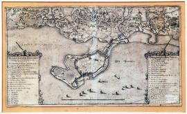
Lindau, On
05.01.1647 (do 08.03.1647)A peninsula cutting into Constance Lake is visible in the top part of the engraving. Lindau lies on this peninsula. The mainland is drawn with much attention to detail. There are few small boats on the lake. The brief German-Latin text and the captions 1-27 and A-N are on rectangular banners supported by two heads of eagles. The eagles are holding the sword and the spectre in their beaks.
Signature: Not available
Autor: Unknown
Original name: Belagerung der Statt Lindau im Bodensee Anno 1647.
Katalogová čísla: Collection Český Šternberk, kód: 374/410
Following the end of fights in Bavaria at the turn of 1646, a difference of opinions on the future war plans arose between Marshal Wrangel and General Turenne. The conflict deepened to such an extent that Turenne decided to march with his army to Württemberg while Wrangel sat out across Swabia to Lake Constance, where he intended to spend the winter. He carried out a couple of successful combats against the local Imperial garrisons in this area. Just before the Swedish moved away from this area to the northeast to Cheb, they had managed to conquer the island with the Mainau fortress on Lake Constance, located approximately 10 km north of Konstanz. At the same time (between 5 January and 8 March 1647) the Swedish also besieged and conquered the small town of Lindau situated on a peninsula in Lake Constance.
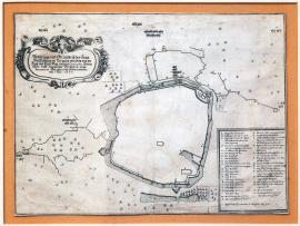
Weißensberg, On
01.02.1647This engraving depicts the plan of the town of Weissenburg and its near surroundings in great detail. The author left out the details of the town centre paying attention only to the bulwark and various fortification constructions that surrounded the town. There are small troops of soldiers and trees in various places in the countryside around the town. There is a richly adorned cartouche on the top left with the above-mentioned German explanatory text. The caption A-Z and 1-13 is in the rectangular banner at the bottom right.
Signature: Hans Gulielm von Blofeldt ing. fecit.
Autor: Blofeldt Hans Gulielm ing., kartograf
Original name: Abbildung und Grundrisz der Statt Weissenburg im Norgaw, wie solche von den Kays. und Churbayr. unterm Commando Herrn General-Feldtzeugmeistern vonn Fernemont belägert und erobert worden, den 1. Feber 1647.
Katalogová čísla: Collection Český Šternberk, kód: 372/457
The engraving depicts one of the last war episodes in Bavaria, fought just before a truce signed between the Elector Maximillian of Bavaria and the Swedish and French forces in Ulm in March 1647. Weissenburg lies approximately 30 km south of Nuremberg. As soon as the Swedish occupied Weissenburg, they marched to Lake Constance leaving only a small garrison in the seized town. Meanwhile the Imperial army moved to Bohemia. The Duke Maximillian of Bavaria was forced to sign the truce with the enemy as his country was completely exhausted by the war. However soon enough, in the autumn of the same year, Bavaria returned to the war.
Mainau, On
03.02.1647This engraving shows the island in Lake Constance with the Mainau fortress under the Swedish attack. The depicted fight is unusually capturing. The conquerors first sailed to the island and then attacked the fortress. There is an oval banner wrapped in the Lauer wreath with the brief German explanatory text describing the depicted event. The caption A-L is placed on the opposite side.
Signature: G. W. Kleinsträttl Quartiermeister Leutnant delineavit.
Autor: Kleinsträtl G. W., Generalquartiermeister, vojenský kartograf
Original name: Abbildung der Insul und Vestung Maynaw, wie dieselbe von Ihr. Excell. Herrn Feldmarschallen Carl Gustav Wrangeln den 3. Feb. Anno 1647 eingenommen worden.
Katalogová čísla: Collection Český Šternberk, kód: 373/463
Following the end of fights in Bavaria at the turn of 1646, a difference of opinions on the future war plans arose between Marshal Wrangel and General Turenne. The conflict deepened to such an extent that Turenne decided to march with his army to Württemberg while Wrangel sat out across Swabia to Lake Constance, where he intended to spend the winter. He carried out a couple of successful combats against the local Imperial garrisons in this area. Just before the Swedish moved away from this area to the northeast to Cheb, they had managed to conquer the island with the Mainau fortress on Lake Constance, located approximately 10 km north of Konstanz. At the same time (between 5 January and 8 March 1647) the Swedish also besieged and conquered the small town of Lindau situated on a peninsula in Lake Constance.
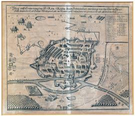
Schweinfurt, On
31.03.1647 (do 15.04.1647)This is the so-called bird’s eye view of the well-fortified town of Schweinfurt. There are only a few besieging Swedish units in the surroundings. The river Maiz flows in the foreground and there are deep forests in both bottom corners. An orienteering compass is placed on the left. The factual and topographical caption 1-19 and A-F is at the top right. The above word-for-word cited German explanatory text is placed above the picture.
Signature: Not available
Autor: Unknown
Original name: Belag. und Eroberung des H. Röm. Reichs Stadt Schweinfurt, wie selbige von des Herrn Gener. Feldtzeugmeister Carl Gustav Wrangels Excell. im Monat Aprill dieses Jahrs vorgenommen und ausgeführet worde. 1647.
Katalogová čísla: Collection Český Šternberk, kód: 375/275
When Marshal Wrangel with his Swedish army left their,winter lodgings’ on the banks of Lake Constance in the spring of 1647, he headed to the West Bohemia. On the way his army besieged the Imperial town of Schweinfurt, and conquered it on 11 April. Afterwards, the Swedish continued to the northeast, invading Bohemia, where they seized the town of Cheb. However, they did not stay long in this part as the Imperial army, led by the General Holzappel (originally named Melander), was getting closer from the South Bohemia. Several minor and major battles were fought in the West Bohemia at that time between the advanced troops of the two enemies.
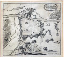
Schweinfurt, On
15.04.1647This is a schematic outline of the town of Schweinfurt with only the main buildings and fortification walls done in detail. The river Maiz flows behind the town. There is an island with a stronghold connected to the land by a bridge. Artilleries and sections of deep broadleaved forest are in various places around the town. The German explanatory text is in a banner, wrapped by the Lauer wreath, at the top right.
Signature: G. W. Kleinsträtl, Quartier M. L. delin.
Autor: Kleinsträtl G. W., Generalquartiermeister, vojenský kartograf
Original name: Verzeichniss der Statt Schweinfurt wie dieselbe von Ihr. Excell. den Herrn Feldtmarschallen Carl Gustav Wrangeln den 15. Aprilis A. 1647 mit accord eingenommen worden.
Katalogová čísla: Collection Český Šternberk, kód: 376/280
When Marshal Wrangel with his Swedish army left their,winter lodgings’ on the banks of Lake Constance in the spring of 1647, he headed to the West Bohemia. On the way his army besieged the Imperial town of Schweinfurt, and conquered it on 11 April. Afterwards, the Swedish continued to the northeast, invading Bohemia, where they seized the town of Cheb. However, they did not stay long in this part as the Imperial army, led by the General Holzappel (originally named Melander), was getting closer from the South Bohemia. Several minor and major battles were fought in the West Bohemia at that time between the advanced troops of the two enemies.
Armentières, On
30.05.1647The town of Armentières is in the centre of the print, which was engraved to resemble a map. The attacking Spanish and Imperial troops are in the near surroundings of the town. The river Lys zigzags across the entire depicted landscape. The above-mentioned German explanatory text is on a ribbon banner at the top right. Below it is an Eagle with the emblem of the Knights of the Cross. It is the coat-of-arms of Leopold Wilhelm, who was the Grand Master of the Order (the Knights of the Teutonic Order). The caption A-Y is in a rectangular banner on the left.
Signature: Not available
Autor: Unknown
Original name: Belägerung Armentirs in Flandern von den Spanischen underm Begleitt Ihrer hochfürstl. Durchl. Ertzherzog Leopold Wilhelm, den 30 May 1647 zur Uibergab bezwungen.
Katalogová čísla: Collection Český Šternberk, kód: 377/307
Armentières was a border fortress between the Netherlands and France. As fight between the Spanish, French and Dutch were commonplace in this area throughout the entire 17th century the fortified strongpoints on the borders of these states were unavoidably the permanent centre point of fighting. The Spanish reinforced by the army of the Archduke Leopold Wilhelm, a brother of the Emperor, besieged Armentières and conquered the town as well as the fortress on 20 May 1647, despite the attempts of the French Marshal de Gassion to free the town with a strong cavalry regiment. The French garrison of the fortress was forced to surrender.
Cheb, On
14.06.1647 (do 05.07.1647)The town of Cheb situated on the right bank of the river Eger is very nicely drawn, however only the important buildings, churches and fortification constructions are depicted. Army troops, artillery batteries and encampments are in various places around the town. The above-mentioned German explanatory text is in the top left corner in the Lauer wreath. The caption A-CC is on the right.
Signature: G. W. Kleinsträtl delineavit.
Autor: Kleinsträtl G. W., Generalquartiermeister, vojenský kartograf
Original name: Eigentlicher Grundriss der Statt Eger wie die selbe von Ihr. Excell. Herrn Carl Gustaff Wrangel den 14.juny 1647 belägert und den 5. July mit Accord eingenommen worden.
Katalogová čísla: Collection Český Šternberk, kód: 378/433
A truce was signed between the Swedish-French forces and Maximillian of Bavaria in Ulm in 1647. This protected the rear of the Swedish army commanded by the Marshal Wrangel, who immediately sat out to the northeast, seizing the town of Schweinfurt and invading Bohemia. He besieged the town of Cheb on 14 June 1647 claiming it was the key to Bohemia. Meanwhile, however, the Imperial army gathered near České Budějovice under the command of General Count Holzappel, originally named Melander. The Emperor Ferdinand III himself arrived to Budějovice to emphasise the importance of the prepared military campaign. Yet, despite the Imperial army moving closer, the Swedish managed to conquer Cheb, upon,agreement’ on 5 July. However, the neutral stance of the Elector of Saxony and increasing pressure of the Imperial army forced Wrangel to leave Bohemia in the end and march through Thuringia up the Weser river.
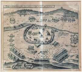
Cheb, On
20.06.1647 (do 17.07.1647)The town is schematically outlined with only the most important buildings and fortification constructions done in detail. The river Eger is outlined as a narrow belt. There are the Swedish troop positions in the surroundings. Several hills are in the background, with the gallous atop one of them. The main Swedish tent is on the bottom left. The coat-of-arms of Cheb is at the top left.
Signature: Not available
Autor: Unknown
Original name: Beläg. und Eroberung der Stadt Eger vom 10. (20.) Juni bisz 7. (17.) Juli Ao. 1647.
Katalogová čísla: Collection Český Šternberk, kód: 379/261
A truce was signed between the Swedish-French forces and Maximillian of Bavaria in Ulm in 1647. This protected the rear of the Swedish army commanded by the Marshal Wrangel, who immediately sat out to the northeast, seizing the town of Schweinfurt and invading Bohemia. He besieged the town of Cheb on 14 June 1647 claiming it was the key to Bohemia. Meanwhile, however, the Imperial army gathered near České Budějovice under the command of General Count Holzappel, originally named Melander. The Emperor Ferdinand III himself arrived to Budějovice to emphasise the importance of the prepared military campaign. Yet, despite the Imperial army moving closer, the Swedish managed to conquer Cheb, upon,agreement’ on 5 July. However, the neutral stance of the Elector of Saxony and increasing pressure of the Imperial army forced Wrangel to leave Bohemia in the end and march through Thuringia up the Weser river.
Cheb, On
05.07.1647This engraving depicts the landscape around Cheb with the river Eger flowing across. The town is only schematically outlined in a relatively small scale. The encampments of the two enemies are on both sides of the town. The brief German explanatory text is in the Laurel wreath in the top left corner. The caption A-V and 1-10 is at the top right.
Signature: G. W. Kleinsträtl Gen. Quartiermeister Leut. delineavit.
Autor: Kleinsträtl G. W., Generalquartiermeister, vojenský kartograf
Original name: Eigentliche Abbildung beyder des Kayserlichen und der schwedischen Veldlägers bey Eger, im Julio 1647.
Katalogová čísla: Collection Český Šternberk, kód: 380/435
A truce was signed between the Swedish-French forces and Maximillian of Bavaria in Ulm in 1647. This protected the rear of the Swedish army commanded by the Marshal Wrangel, who immediately sat out to the northeast, seizing the town of Schweinfurt and invading Bohemia. He besieged the town of Cheb on 14 June 1647 claiming it was the key to Bohemia. Meanwhile, however, the Imperial army gathered near České Budějovice under the command of General Count Holzappel, originally named Melander. The Emperor Ferdinand III himself arrived to Budějovice to emphasise the importance of the prepared military campaign. Yet, despite the Imperial army moving closer, the Swedish managed to conquer Cheb, upon,agreement’ on 5 July. However, the neutral stance of the Elector of Saxony and increasing pressure of the Imperial army forced Wrangel to leave Bohemia in the end and march through Thuringia up the Weser river.
Planá, On
09.08.1647This engraving depicts the landscape around the towns Planá near Tachov. There are two large field encampments, the Imperial and the Swedish. Various places in the landscape are dotted with strongholds, army troops and guards, individual soldiers and cavalrymen, field camps etc. There are two ribbon banners above and below the map with the brief German explanatory text and the caption A-C and D-N.
Signature: Not available
Autor: Unknown
Original name: Abrisz des Kayserischen und schwedischen Feldlägers zwischen Plan und Tribel in Böhmen den 9. Augusti 1647.
Katalogová čísla: Collection Český Šternberk, kód: 381/272
See the historical commentary on the previous page (303) above. It needs to be added that at the time the Swedish invaded the West Bohemia, some minor fights took place between the advanced troops of both armies. Wrangel seized the castle of Třebel near Planá, leaving there his garrison. However, when part of the Swedish army went foraging on 12 August 1647 the Imperial troops led by John of Werth and Montecucoli attacked the Swedish encampment. In the battle that followed the Swedish lost 10 Swedish banners, 79 officers and many hundreds of men. The young Wilhelm Wrangel was also captured.
Planá, On
12.08.1647This picture depicts a battle which is greatly spread around the hilly terrain, cut by several zigzagging streams. The method of drawing of the forests, as large groups of trees with round treetops, is typical for this period. The Třebel castle near Planá is at the top right. The above-mentioned German explanatory text is placed in the sky, the caption A-N is on a ribbon banner at the bottom right.
Signature: Not available
Autor: Unknown
Original name: Action so zwischen den Keys. und königlich Schwedischen Völkern den 12. Augusti 1647 bey Tribel in Böhmen vorgangen.
Katalogová čísla: Collection Český Šternberk, kód: 382/461
See the historical commentary on the previous page (303) above. It needs to be added that at the time the Swedish invaded the West Bohemia, some minor fights took place between the advanced troops of both armies. Wrangel seized the castle of Třebel near Planá, leaving there his garrison. However, when part of the Swedish army went foraging on 12 August 1647 the Imperial troops led by John of Werth and Montecucoli attacked the Swedish encampment. In the battle that followed the Swedish lost 10 Swedish banners, 79 officers and many hundreds of men. The young Wilhelm Wrangel was also captured.
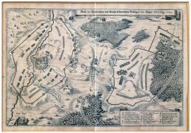
Teplá, On
30.08.1647The small town of Teplá is depicted on the left side of the print. Its monastery is a little lower in the corner. A wide belt of fortification constructions circles the town. The Swedish encampment is on the right side of the engraving near a forest. There are many detailed drawings; for instance patrols, firing cannons, groups of several cavalrymen etc. The river Teplá is outlined on the right side of the print. The brief German explanatory text is on an ornamental ribbon banner in the top right corner and the caption A-Q is on a similar banner on the bottom left.
Signature: Not available
Autor: Unknown
Original name: Abrisz des Kayserischen und Königl. Schwedischen Veldlägers bey Töppel den 30. August 1647.
Katalogová čísla: Collection Český Šternberk, kód: 383/244
The Swedish Marshal Carl Gustav Wrangel got in charge of the Swedish army after his famous predecessor Leonard Torstensson resigned from the rank due to a serious illness in 1646. The focus of the fights moved to the West Germany at that time due to increasing intensive activity of the French forces led by the General Turenne. However, the conflicts of opinions of the two generals regarding the further plans escalated to such extent that both allied armies split. The French marched to the winter encampment in Württemberg while Wrangel led his army to spend the winter near Lake Constance. In spring 1647 Wrangel decided to invade the Austrian hereditary lands but was forced to change his intentions when the Elector of Bavaria Maximillian singed a truce with the Spanish and French in March. Due to this Wrangel could not carry out his intention to march outside the Bavarian territory to Vienna in order not to breach the conditions of the truce. Therefore he went to the northeast invading Bohemia near Cheb. Meanwhile, the Imperial army was gathering near Budějovice under the command of Count Holzappel (originally named Melader). Even the Emperor Ferdinand III himself went to Budějovice to emphasise the importance of the prepared military campaign. However before the Imperial troops could reach the West Bohemia, Wrangel managed to seize Cheb on 5 July. Allegedly the Imperial army was hold by the necessity to avoid the lands of the Count Schlick in order not to cause any damage to it. The depicted fight near Teplá took place on 30 August, i.e. almost two months after the fall of Cheb. Wrangel, despite achieving several important successes in Bohemia, was in the end forced to leave the country due to strategic reasons. The pressure of the Imperial army from the southeast was increasing, the Bavarians breached the truce in the autumn of 1647 and started to carry out military campaigns again threatening thus the rear of the Swedish army and the neutral stance of the Elector of Saxony was so insecure (as clearly documented by his acting throughout the entire war) that Wrangel preferred to withdraw from Bohemia and march across Thuringia to the river Weser.
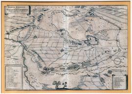
Memmingen, On
09.09.1647 (do 14.11.1647)This is a very detailed and delicately engraved picture. The town of Memmingen is in the right half of the picture surrounded by various fortifications drawn with the unusual attention to detail. Only churches and important buildings are visible in the town centre, the rest of the area is unfilled. The river Iller flows on the left. The lines of conquerors are in a large circle around the town, below is sketched the stream of the small river Büxach. Army troops, individual soldiers and cavalrymen are dotted in various places of the countryside. The above-mentioned inscription is in the ornamental ribbon banner at the top left. The military caption 1-18 is at the bottom of the same side in a rectangular banner. There is an unrolled vignette with the topographical caption A-L is in the right bottom corner. The author of this etching is unknown.
Signature: Not available
Autor: Unknown
Original name: Obsidio Memmingiae 1647. Belägerung der Reichstadt Memmingen von dem 9. September biss auff den 14. Novembris 1647.
Katalogová čísla: Collection Český Šternberk, kód: 384/27
The Elector of Bavaria Maximillian singed a truce with the French and the Spanish in Ulm in March 1647, however he soon realised that this step was taking away the prestige of the Imperial-Catholic movement during the peace negotiations, which were carried out at this time in Münster. Therefore he declared war again in the autumn of 1647 sending a part of his army to Bohemia to help the Imperial army led by Holzappel. The rest of his army was sent to Swabia to besiege the town of Memmingen, as is shown on the described copper engraving.
Jihlava, On
07.12.1647This large engraving depicts the town of Jihlava and its surroundings at the time of its siege by the Imperial army. The town itself is only schematically outlined; while the fortification constructions and various military scenes are done with a remarkable attention to detail. There is a large baroque cartouche in the top right corner with an extensive caption 1-29. Opposite is a rectangular banner with further caption A-O. There is a minor scene with three officers in the right foreground.
Signature: Not available
Autor: Unknown
Original name: Die Statt Iglaw in Mähren ist den 12. Marti von dem Feindt occupiert, im Jahr 1645. An iezo aber von Herrn Feldzeugmeistern Grafen von Pucheim den 2. December 1647 wieder erobert worden.
Katalogová čísla: Collection Český Šternberk, kód: 385/229
Following the defeat of the Imperial army in the Battle of Jankov in February 1645 the victorious General Torstensson moved eastwards and seized the town of Jihlava on 12 March 1645. Leaving a garrison in the town he then continued his campaign to Lower Austria marching to Vienna. However, his march was hampered by the massive Danube river and an increased resistance of the Imperial army. The Swedish army entered deep into the territory of its enemy and lacked direct connection with their supply centres. Moreover, they had the unconquerable fortress, the city of Brno with the Špilberk castle behind them, and Torstensson could not afford to have such a strategically important strongpoint in his rear. The otherwise brilliant strategist was long suffering from a serious kidney disease, which did not allow him to command his army adequately. He was unable to carry on any longer at the beginning of summer 1646 and went back to Sweden. The Imperial forces managed to free Jihlava and its surroundings from the Swedish occupation only much later, on 7 December 1647, i.e. 2 years and 9 months after its occupation. Following the peace with Rakoczy, the army commanded by General Puchheim was free to march from the east to the Czech Kingdom, where the Archduke Leopold Wilhelm, a brother of the Emperor, commanded his army. First of all, it was necessary to oust out the Swedish garrisons from the strongholds on the Austrian territory, therefore Puchheim got to Jihlava only at the turn of 1647 and conquered it on 7 December. This is depicted on the described copper engraving.
Jihlava, On
07.12.1647The town of Jihlava lies in the centre of the print. It is drawn in great detail including the fortification constructions. The town is surrounded by enemy’s trenches. The area around the town is divided into squares with depicted army troops, encampments, fortifications and groups of cavalry and infantry. The village of Jezuvice with the main tent of the General Field Gunner (i.e. the artillery general) Puchheim is at the top left. The rivers Malá Jihlava and Velká Jihlava are very distinctively outlined in the landscape very distinctively. The above-mentioned text is placed directly in the picture part of the engraving.
Signature: Not available
Autor: Unknown
Original name: Abrisz und Belägerung der königl. Statt Iglau in Mähren, wie selbige nach 4 monatlicher real-Belägerung und endlich am 7. Dezember Anno 1647 durch kays. H. General Feldzeugmeister Joh. Christoph Grafen von Buchheim mit Accord wiedergenommen worden.
Katalogová čísla: Collection Český Šternberk, kód: 386/289
Following the defeat of the Imperial army in the Battle of Jankov in February 1645 the victorious General Torstensson moved eastwards and seized the town of Jihlava on 12 March 1645. Leaving a garrison in the town he then continued his campaign to Lower Austria marching to Vienna. However, his march was hampered by the massive Danube river and an increased resistance of the Imperial army. The Swedish army entered deep into the territory of its enemy and lacked direct connection with their supply centres. Moreover, they had the unconquerable fortress, the city of Brno with the Špilberk castle behind them, and Torstensson could not afford to have such a strategically important strongpoint in his rear. The otherwise brilliant strategist was long suffering from a serious kidney disease, which did not allow him to command his army adequately. He was unable to carry on any longer at the beginning of summer 1646 and went back to Sweden. The Imperial forces managed to free Jihlava and its surroundings from the Swedish occupation only much later, on 7 December 1647, i.e. 2 years and 9 months after its occupation. Following the peace with Rakoczy, the army commanded by General Puchheim was free to march from the east to the Czech Kingdom, where the Archduke Leopold Wilhelm, a brother of the Emperor, commanded his army. First of all, it was necessary to oust out the Swedish garrisons from the strongholds on the Austrian territory, therefore Puchheim got to Jihlava only at the turn of 1647 and conquered it on 7 December. This is depicted on the described copper engraving.
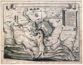
Jihlava, On
07.12.1647This is a well-arranged plan of Jihlava and its surroundings with various fortification constructions, trenches and bulwarks. This engraving is very similar to the engraving No. 385/299 (pgs. 307 and 308). There is an ornamental ribbon banner above the picture with the brief above-mentioned German explanatory text. The caption A-O is placed on a similar slightly wider vignette.
Signature: Not available
Autor: Unknown
Original name: Belagerung der Statt Iglau durch Herrn Feldzeugmeistern Grafen von Puchheim so den 7. Dezember 1647 erobert worden.
Katalogová čísla: Collection Český Šternberk, kód: 387/374
Following the defeat of the Imperial army in the Battle of Jankov in February 1645 the victorious General Torstensson moved eastwards and seized the town of Jihlava on 12 March 1645. Leaving a garrison in the town he then continued his campaign to Lower Austria marching to Vienna. However, his march was hampered by the massive Danube river and an increased resistance of the Imperial army. The Swedish army entered deep into the territory of its enemy and lacked direct connection with their supply centres. Moreover, they had the unconquerable fortress, the city of Brno with the Špilberk castle behind them, and Torstensson could not afford to have such a strategically important strongpoint in his rear. The otherwise brilliant strategist was long suffering from a serious kidney disease, which did not allow him to command his army adequately. He was unable to carry on any longer at the beginning of summer 1646 and went back to Sweden. The Imperial forces managed to free Jihlava and its surroundings from the Swedish occupation only much later, on 7 December 1647, i.e. 2 years and 9 months after its occupation. Following the peace with Rakoczy, the army commanded by General Puchheim was free to march from the east to the Czech Kingdom, where the Archduke Leopold Wilhelm, a brother of the Emperor, commanded his army. First of all, it was necessary to oust out the Swedish garrisons from the strongholds on the Austrian territory, therefore Puchheim got to Jihlava only at the turn of 1647 and conquered it on 7 December. This is depicted on the described copper engraving.
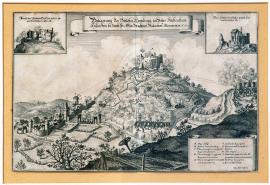
Homburg, On
01.01.1648 (do 31.12.1648)The engraving depicts a fortress situated on top of a high hill, with a small town lying below. To the right there are several artillery batteries firing at the castle. Ballistic curves of the fired projectiles are plotted with precision. On both top sides there are separate fields with detailed views of Homburg castle. In the middle there is a ribbon with a brief explanatory text in German. In the bottom to the right there is caption: A-L.
Signature: Not available
Autor: Merian Caspar, mědirytec
Original name: Belägerung des Schlosses Homburg im Unter Fürstenthum Hessen, wie solches durch Herrn General Wachtmeister Rabenhau eingenommen An. 1648.
Katalogová čísla: Collection Český Šternberk, kód: 413/270
The engraving undoubtedly depicts the siege and conquest of a minor formation of imperial troops by the Swedes and the French. The imperial troops led by Holzappel-Melander, passed to Bavaria at the end of 1647. The Swedish-French army under the command of Turenne and Wrangel was following them early in 1648 after having spent the winter in Rhineland. During this campaign, Homburg castle was apparently besieged and captured by General Rabenhau, in which an imperial garrison had been left. Homburg vor der Höhe is located some 25 km to the north of Frankfurt am Main.
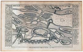
Breisach, On
01.01.1648 (do 31.12.1648)The copper engraving depicts the situation in Breisach am Rhein. The flow of the Rhine is branching here into several arms. The town is surrounded by fortification system. The upper inscription is placed into the image of the graphic. An extensive text in German is written along both sides of the picture. It brings details on the history of Breisach and includes topographic (1-12) and material (a-c) caption.
Signature: Johann Stridbeck junior sculp. et excud. Aug. Vind.
Autor: Stridbeck Johann junior, mědirytec v Augsburgu
Original name: Breisach, wie es bey Schliesung des teutschen Friedens gewesen.
Katalogová čísla: Collection Český Šternberk, kód: 414/444
Windesheim, On
20.02.1648The town is only schematically outlined, while the bulwark and fortifications are done in detail. The river Aische flows on the right side. There are three firing artillery batteries and two Swedish regiments on the left. There is an access trench along the bottom. The landscape around the town is divided into square and rectangular fields. The German explanatory text is in the decorated oval cartouche at the top right. The caption A-L is at the bottom right.
Signature: Per Cornelium van den Busch, Generalquartiermeister.
Autor: Dusch Cornelius van den, Generalquartiermeister, nizozemský kartograf
Original name: Eigentlicher Abrisz der Reichstatt Windesheimb, wie dieselbe von den Schwedischen durch Ihr. Excel. Herrn General und Feldtmarschallen Carll. Gustav Wrangeln am 29. Februari 1648 belagert und den 3. Martij erobert worden.
Katalogová čísla: Collection Český Šternberk, kód: 388/269
Two armies were facing each other in Rhineland towards the end of 1647, the Swedish-French army commanded by Turenne and Wrangel and the Imperial force commanded by Melander (Holzappel). Due to the rather difficult supply situation and low numbers of soldiers, General Melander decided to leave Rhineland and move to Ingolstadt in Bavaria. Clashes of opinions on further plans arose once again between Wrangel and Turenne and made the Swedish to leave and move to the winter encampments near the river Maiz. On the way Wrangel conquered the Imperial city of Windesheim, situated approximately 15 km north of Kreuznach, to make a strategic strongpoint for further manoeuvres of his army. Windesheim was occupied by the Swedish on 3 March 1648.
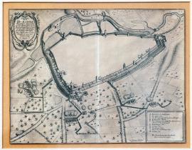
Dinkelsbühl, On
07.04.1648This engraving depicts the town of Dinkelsbühl in Bavaria above the river Wörnitz from the so-called bird’s eye view. As usually the engraver did not pay attention to the town centre leaving there only a white space. However the fortification constructions, access trenches and bulwark around the town are done in detail. There are also several fortification towers depicted. Around the town are several firing artillery positions of the conquerors with outlined ballistic trajectories ending in the hit military targets in the town. The countryside around Dinkelsbühl is divided into rectangular fields; there is one tree with round treetop in each field. We can often observe this method of drawing of the terrain. There are no specific landscape features on many contemporary engravings. The engravers of the Thirty Years’ War, who depicted the military actions, were usually fortification engineers (,Quartiermeistr’) who paid attention mainly to the military components of their,original drawings’ and left out or just roughly schematically and stereotypically sketched all other topics (i.e. buildings, landscape, figures etc.). There is an ornamental cartouche with the brief German text explaining the depicted event at the top left. The caption A-K and the signature of Cornelius van den Busch are in a rectangular banner on the bottom right.
Signature: Carl Henric. de Osten ingen. delineavit. Per Cornelium van den Busch, Generalquartiermeister.
Autor: Osten Carl Henricus, fortifikační inženýr
Original name: Eigentlicher Abrisz der Reichstadt Dünkslspill, wie dieselbe von den Schwedischen durch Ihre Excellenz Herrn General und Feldmarschalln Carl Gustav Wrangeln am 7. Aprilis 1648 Belägert und am 11. dito erobert worden.
Katalogová čísla: Collection Český Šternberk, kód: 389/11
The intensity of fights as well as the original fanatical persistence of the fighting movements decreased noticeably in the last years of the Thirty Years’ War. Moreover, the large armies, which in the Wallenstein’s era counted tens of thousand men, now had merely several thousand tired soldiers. As soon as Maximillian of Bavaria restarted fighting following the short truce, several minor fights took place in Bavaria and adjoining countries during the spring of 1648. The Imperial army in this area was commanded by General Field Gunner Count Holzappel (originally named Melander), while the Bavarian troops were led by the Count Gronsfeld. The Swedish led by Wrangel came from the north, seized the Imperial town of Dinkelsbühl on 11 April 1648 and joined their detached unit commanded by General Königsmark. At the same time the Swedish allied with the French commanded by the excellent Turenne, who, however, disliked Wrangel. The conquest of Dinkelsbühl is the topic of the described copper engraving.
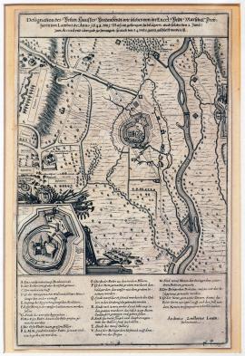
Bredenbendt, On
01.05.1648This is a letter-size engraving depicting the area of the small river Rur with the fortress of Bredenbendt situated approximately 25 km southeast of Monchengladbach in the West Germany. There is an ornamental cartouche in the bottom left corner with army emblems and a construction detail of the,fortified house’ of Bredenbendt. The above-mentioned German explanatory text is above the plan; the caption A-Y is placed below it.
Signature: Andreas Zeidlerus Leutnant delineavit.
Autor: Zeidlerus Andreas, poručík, kreslíř map a plánů
Original name: Designation des Vesten Hauses Bredenbendt, wie solches von ihr. Excel. Feldmarschall Freyherrn von Lamboy etc. Anno 1648 den 1. May angefangen zu belägern auch solchs den 2. Juny zum Accord und Uibergab gezwungen so auch den 3. 4. und 5. gantz geschleift worden ist.
Katalogová čísla: Collection Český Šternberk, kód: 390/382
The military situation of the Imperial-Bavarian movement became especially difficult during the last months of the Thirty Years’ War, as its main armies were forced by the Swedish-French forces to withdraw from Bavaria to the southeast and into the Austrian hereditary countries. The Duke Maximillian of Bavaria himself had to solicit shelter and protection in Salzburg. Prague was partially occupied by the Swedish under Königsmark. Only just before the end of the war the power proportion between the both fighting sides shifted to the advantage of the Imperial forces. This turn of the situation was caused by the so-called French,Fronde’, a conspiracy and uprising of the French aristocracy and noblemen led by (the person familiar to us from the events of the last year),Le Grand Condé’, i.e. the Prince d’Enghien, the Duke of Condé, Louis II de Bourbon. Indeed the internal fights weakened the potential of the French army in the West Germany considerably, and most of their forces were recalled back to their homeland. The Imperial army managed to force Königsmark to leave Prague and the Imperial General Lamboy carried out several successful campaigns in the South-West Germany. One of them was the conquest of the Bredenbendt fortress on 2 June 1648, which is depicted on the described copper engraving.
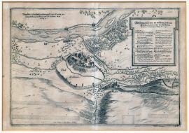
Freising, On
01.05.1648 (do 10.05.0648)The river Isar with several islands and the town of Freisingen (situated approximately 20 km northeast of Munich) on its left bank is depicted on the left side of this engraving. The picture is done very precisely. There is a rectangular banner on the right side with the above text and the caption A-N on the right side. The following inscription:,Transitus confoederatorum Exercitum per Isaram Bavaiae fluvium subexitum May 1648’ is in the top left corner of the picture.
Signature: Durch Cornelium van dem Busch General-Quartiermeister
Autor: Dusch Cornelius van den, Generalquartiermeister, nizozemský kartograf
Original name: Abbildung wo und an welchem Orth die Allyrten Armeen über den Iserfluss gekommen zu Anfang des Mays Anno 1648.
Katalogová čísla: Collection Český Šternberk, kód: 393/350
The military situation of the Imperial-Bavarian forces was very unfavourable during the last months of the Thirty Years’ War. The army led by Holzappel was defeated near Zusmarshausen, the Bavarian General Gronsfeld was forced to withdraw southwards and the way into the heart of Bavaria and the Imperial hereditary lands was thus open to the enemy. The Duke Maximillian of Bavaria fled to Salzburg and the French-Swedish allies under Turenne and Wrangel crossed the river Isar near Freisingen and marched eastwards. This event that took place in the first half of May 1648 is depicted on the described copper engraving.
řeka Lech, On
01.05.1648 (do 30.05.1648)The river Lech flows through the depicted landscape from the left to the right, flanked by deep forests on both sides. There are firing musketeers on both banks and several Swedish artillery batteries on the left bank. The position of both armies is outlined on both banks of the Lech. There is an ornamental cartouche on the bottom left with the Latin-German text and the caption A-I.
Signature: Durch Cornelium van den Busch Generalquartiermeistern Carl Henrico a Osten ing. delineavit.
Autor: Osten Carl Henricus, fortifikační inženýr
Original name: Eigentliche Abbildung wie und an welchem Orth die alliierten Arméen über den Lechstrom in Bayern gekommen. Im Mayo 1648.
Katalogová čísla: Collection Český Šternberk, kód: 394/445
The last year of the Thirty Years’ War was critical for the Imperial-Bavarian forces. Its armies marched as far as the Lech pushed by the moving Swedish-French army commanded by Wrangel and Turenne. When discords arose between the French and the Weimar units, commanded by Königsmark, Wrangel tried to calm the situation down and ordered Königsmark to march with his units to Bohemia to join the troops of Arwed Wittenberg. Wrangel with Turenne then forcefully crossed the river Lech in May 1648 and forced the Imperial-Bavarian army led by Gronsfeld, which was in its state unable to carry out any effective counteraction, to withdraw further to the southeast.
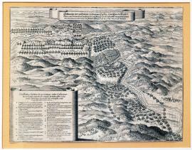
Zusmarshausen, On
07.05.1648This engraving depicts a very hilly forested countryside. At the top left is the position of the armies; numerous convoys are marching to the same place. The above-mentioned text is on an ornamental ribbon banner at the top. There is an unrolled vignette at the bottom left with the same text in Latin with the name of the place of the fight: Zusmarskhausen, situated near Augsburg. The caption A-V is below the picture.
Signature: Carl Henric: á Osten ingen. delineavit.
Autor: Osten Carl Henricus, fortifikační inženýr
Original name: Schleunige oder geschwinde Action und Treffen so zwischen der Kayserl. Armee unter dem Comand. des Herrn Gen. und Feldmars. Graff Holttzapffell und gegentheils Schwed. unter dem Command. des Herrn Gen. und Feldmars. Wrangels Excell. den 7. May Anno 1648 fürgangen.
Katalogová čísla: Collection Český Šternberk, kód: 391/35 D
The fights were led mainly in the West Germany during the last year of the Thirty Years’ War. The Imperial-Bavarian army operating in this area was commanded by the General Field Gunner Count Holzappel, originally named Melander, and the Bavarian General Gronsfeld. The Swedish-French forces in this area were commanded by Wrangel and Turenne. A battle erupted between both armies on 7 May near Zusmarskhausen not far Augsburg, in which the Imperial army was defeated. Its main commander Holzappel was mortally wounded and died soon after in Augsburg, where he was hastily transported after the battle.
Zusmarshausen, On
07.05.1648This engraving depicts a very hilly forested countryside. At the top left is the position of the armies; numerous convoys are marching to the same place. The above-mentioned text is on an ornamental ribbon banner at the top. There is an unrolled vignette at the bottom left with the same text in Latin with the name of the place of the fight: Zusmarskhausen, situated near Augsburg. The caption A-V is below the picture.
Signature: Carl Henric: á Osten ingen. delineavit.
Autor: Osten Carl Henricus, fortifikační inženýr
Original name: Schleunige oder geschwinde Action und Treffen so zwischen der Kayserl. Armee unter dem Comand. des Herrn Gen. und Feldmars. Graff Holttzapffell und gegentheils Schwed. unter dem Command. des Herrn Gen. und Feldmars. Wrangels Excell. den 7. May Anno 1648 fürgangen.
Katalogová čísla: Collection Český Šternberk, kód: 392/198
The fights were led mainly in the West Germany during the last year of the Thirty Years’ War. The Imperial-Bavarian army operating in this area was commanded by the General Field Gunner Count Holzappel, originally named Melander, and the Bavarian General Gronsfeld. The Swedish-French forces in this area were commanded by Wrangel and Turenne. A battle erupted between both armies on 7 May near Zusmarskhausen not far Augsburg, in which the Imperial army was defeated. Its main commander Holzappel was mortally wounded and died soon after in Augsburg, where he was hastily transported after the battle.
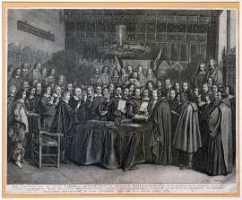
Münster, On
15.05.1648This is a large engraving depicting the ceremonial peace ratification signed between the long-standing war opponents – the Spanish and the Dutch. There is a large table in the centre of the picture covered by a blanket and many documents, various books and other paperwork. A large group of people is gathered behind the table. One dignitary is placing his hand on a crucifix and Gospel taking an oath. It is the emissary of the Spanish king Count Seneranda. The commander of Münster garrison is standing behind a chair on the left. The original of the picture (by Dutch painter Terbuch) is in the London National Gallery; a small oil painting copy is in Münster. There is a chandelier with the Virgin Mary in the depicted hall with the peace conference gathering. There is an inscription:,Pax optima rerum’ on the wall.
Signature: Geraert Terburch pinxit. – Jonas Suyderhoef sculpsit.
Autor: Terburch Geraert, nizozemský malíř
Original name: Icon exactissima, qua ad vivum exprimitur solennis conventus legatorum plenipotentiarum Hispaniarum regis Philippi IV. et ordinum generalium faederati Belgii, qui pacem perpetuam paullo ante sancitam extraditis utrinque instrumentis iuramento confirmarunt, monasterii Westphalorum in domo senatorio. Anno CI I C XLVIII. idibus Maii.
Katalogová čísla: Collection Český Šternberk, kód: 395/285
The peace between Spain and the Netherlands was signed on 15 May 1648, i.e. a few months earlier than the so-called Peace of Westphalia, which ended the Thirty Years’ War, and was ratified also in Münster on 24 October 1648. This particular ratification between Spain and the Netherlands ended the so-called Eighty Years’ War, which had been fought between the two countries since 1568, and which later became part of the geographically more extensive Thirty Years’ War. The peace was hugely important for the Netherlands. The country became the financial and economical centre of the then world in the 17th century, boasting many oversees commercial bases and colonies. However, as for its size it could not compare with other European powers and its integrity was further threatened by the ongoing war with Spain. Spain was still to keep a part of the Dutch territory, the so-called Spanish Netherlands (approximately the area of the present-day Belgium), however the rest of the provinces with the paramount protestant faith definitely separated and becoming independent they were free of any Spanish claims.
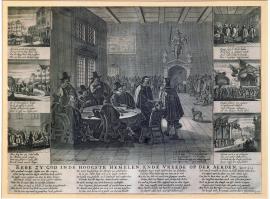
Münster, On
15.05.1648This large engraving of the Dutch origin shows the signing of the peace between Spain and the general states of the Netherlands. Several men wearing large hats are seated around a round table in the centre of the picture. One of them is handing a document to a standing man. A large audience is in the background and there is a small dog on the right. There is also an arch with the Justice allegory. There are three detailed banners on both sides of the main picture, with short texts explaining the individual scenes of the peace gathering. The above-mentioned quotation from the Luke Gospel is below the picture. There is also a Dutch peace poem.
Signature: Rombut vanden Hoeye excud.
Autor: Hoeye Rombut van den, nizozemský rytec
Original name: Eere zy God inde hoogste Hemelen, ende vreede op der Aerden. Luce 2. 14.
Katalogová čísla: Collection Český Šternberk, kód: 396/466
The peace between Spain and the Netherlands was signed on 15 May 1648, i.e. a few months earlier than the so-called Peace of Westphalia, which ended the Thirty Years’ War, and was ratified also in Münster on 24 October 1648. This particular ratification between Spain and the Netherlands ended the so-called Eighty Years’ War, which had been fought between the two countries since 1568, and which later became part of the geographically more extensive Thirty Years’ War. The peace was hugely important for the Netherlands. The country became the financial and economical centre of the then world in the 17th century, boasting many oversees commercial bases and colonies. However, as for its size it could not compare with other European powers and its integrity was further threatened by the ongoing war with Spain. Spain was still to keep a part of the Dutch territory, the so-called Spanish Netherlands (approximately the area of the present-day Belgium), however the rest of the provinces with the paramount protestant faith definitely separated and becoming independent they were free of any Spanish claims.
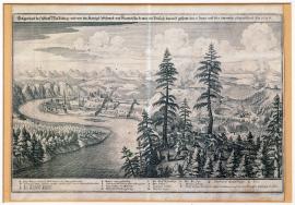
Wasserburg, On
05.06.1648There is a hill with two huge trees and a Swedish battery of three cannons on the right side of the engraving. The artillery is firing at the town of Wasserburg, which is situated on a peninsula cutting into the river Inn. Wasserburg lies approximately 45 km north of the Bavarian-Austrian borders. The brief German explanatory text is above the picture and the caption A-P is below it.
Signature: Not available
Autor: Unknown
Original name: Gelegenheit der Statt Wasserburg und wie die königl. Schwed. und Französische Armen ein Versuch darauf gethan den 5. Juny und den 8. dito wieder abmarschiert. Anno 1648.
Katalogová čísla: Collection Český Šternberk, kód: 397/352
The allied French-Swedish army commanded by Turenne and Wrangel overpowered considerably the Imperial-Bavarian troops led by Gronsfeld in 1648. Following the defeat in the Battle of Zusmarshausen in Bavaria on 7 May 1648, where General Holzappel was mortally wounded, the Imperial forces were no longer able to withstand the French-Swedish pressure and kept withdrawing to the southeast. Wrangel and Turenne forcefully crossed the river Lech in the same place as once Gustav Adolph did. The Duke Maximillian of Bavaria was forced to leave the Munich hastily and seek shelter in Salzburg. The Imperial-Bavarian army withdrew and crossed the Inn. However, when the pursuing French-Swedish troops arrived to the river, there could not cross it near Wasserburg or Müldorf, not due to successful defence of the enemy but due to high waters on the river caused by heavy spring rains. Following a couple of unsuccessful attempts to wade the swollen river, the Swedish-French army turned back. Meanwhile, Gronsfeld was enforced by the army of Piccolomini and Enkefort and any further Swedish-French invasion into the Austrian inland was out of question.
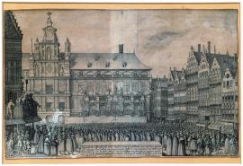
Antwerpen, On
05.06.1648This is a very delicately etched picture. The composition of its topic shows the hand of a skilful artist with refined taste. In the background is the town hall of Antwerp. In front of it is a platform with a spokesman standing behind a stand. The square is crowded. There is a block of houses with medieval gables on the right. While on the left is a balcony with several seated people, possibly the town dignitaries. The town hall boasts a beautiful Renaissance gable. The stated Dutch text is placed in a rectangular banner in the middle of the bottom of the picture.
Signature: F. v. Wyngaerdde excud. W. Hollar fecit
Autor: Wyngaerde F. V., nizozemský mědirytec
Original name: Eygentlycke Afbeeldinghe ende maniere van de publicatie van den Peys taschen syna Mayesteyt den Connick van Spagnien ende Heeren Staten Generael van de vereenich Nederlanden op eene stellagie voor het Stadthuys van Antwerpen ter presentie van de Heeren Schouleth, Amptman Borghemeesters, Schep etc. ende een grote menichte van toehorders 5. Juny 1648.
Katalogová čísla: Collection Český Šternberk, kód: 398/472
The peace between Spain and the general states of the allied Netherlands was ratified on 15 May 1648 in Münster and declared to the Dutch public on 5 July of the same year in Antwerp. This event is depicted on the described picture by Hollar.
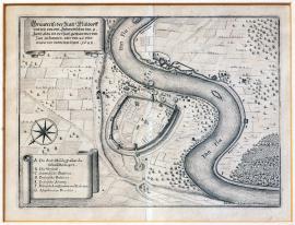
Mühldorf, On
09.06.1648 (do 26.06.1648)The wide watercourse of the Inn divides the engraving into two parts: the town of Müldorf – just schematically sketched - is situated on the left bank, city walls and significant buildings are drawn in detail. On the other bank of the Inn, along the watercourse, there are trenches and lookouts of the French and the Swedes. In the top left corner there is a vignette with explanatory text. In the bottom of the picture there is a ribbon with caption: A– G.
Signature: Johann Merk ingenieur delineavit.
Autor: Merk Johann, inženýr pro opevňovací stavby
Original name: Grundrisz der Statt Müldorff und wie von den schwedischen den 9. Juny ald(s)o ein Versuch gethan über den Inn zu kommen, aber den 26. dito wieder von dannen gezogen. 1648.“
Katalogová čísla: Collection Český Šternberk, kód: 399/291
In 1648, the allied French-Swedish Army led by Turenne and Wrangel had substantial superiority over the combined Austrian-Bavarian troops under the command of General Gronsfeld. After the defeat at Zusmarshausen in Bavaria on 7th May 1648, where general Holzapfel was fatally injured, the imperial army was not able to face the French-Swedish raid any more and was retreating incessantly to the pressure of the enemy towards the south-east. Wrangel and Turenne crossed the Lech river in the same place as had formerly Gustavus Adolphus. The duke Maxmilian of Bavaria was forced to leave Munich hastily and to seek shelter in Salzburg. The Austrian-Bavarian army retreated past the Inn. When the pursuing French and the Swedes arrived to the river, they failed to cross it both at Wasserburg and Müldorf, nevertheless not thanks to any successful countermeasures of the enemy, but due to the unusually high water level in the Inn after heavy spring rains. After several unsuccessful attempts to ford the swollen Inn, the Swedish-French army withdrew. The thing was that in the meanwhile Gronsfeld acquired support for his forces by Piccolomini's and Enkefort's troops and the Swedish-French further advancement into the Austrian inland was hence impossible.
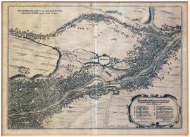
Moosburg, On
01.07.1648 (do 31.08.1648)A map of the forested basin of the Isar river and its tributary the Amber. In the centre of the picture there is the town of Moosburg with only a single building drawn in detail, probably a church. In the top left part there is a Latin, and in the right bottom part there is a German text with caption: A-M. The signatories are listed by the bottom edge of the engraving: “Carl Henric and Osten Ing. Delin.”, and in the decorative vignette:' Durch Cornelium von dem Busch, General. quart. Meister.”
Signature: Not available
Autor: Osten Carl Henricus, fortifikační inženýr
Original name: Eigentliche Delineation und Andeutung beider alliierten Läger und bequemen Standes bey Mosburg. Vedera delineatio castrorum utriusque exercitus foederati ad Mospurgam Anno 1648.
Katalogová čísla: Collection Český Šternberk, kód: 401/276
After the Battle of Zusmarshausen in Bavaria on 7th May 1648, in which the imperial troops were defeated and their commander, Lieutenant General Holzappel-Melander, was fatally injured, the Swedish-French army led by Wrangel and Turenne temporarily settled in the basin of the Isar river near Moosburg and Dingelfing. The engraving depicts the situation in Moosburg, which is located approximately 40 km north-west of Munich in the direction of Lanshut. The imperial and Bavarian troops camped nearby, but were soon forced to retreat to the south-east, beyond the Inn. The Franco-Swedish allies had superiority and pursued the enemy as far as the Inn. The river level was nevertheless severely elevated due to heavy spring rains and the allies were forced to stop their victorious advance aimed at the heart of the Austrian hereditary lands after several unsuccessful attempts to cross the swollen Inn.
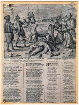
On
01.07.1648 (do 31.12.1648)The engraving depicts a skinny cow bearing a coat of arms of Flanders held by horns with two men and by tail with a priest. Two soldiers are laying under the cow and are sucking milk from its udder. In the background we can see the harbour of Dunkerque. Below the picture read a Dutch and a French poem, containing a discourse amongst all the persons surrounding the cow and marked with letters A - G.
Signature: Not available
Autor: Unknown
Original name: Der Castilianen uyt-vaert: Mitsgaders de Vlaemsche Melck-Koe. Waer in claerlijk vertoont wordenden bedroeften toestant der verheerde Provintien, von Oost en West Vlaenderen. La vache de Flandres dans laquelle on voit comme cette province est réduite par le gouvernement des Castellians.
Katalogová čísla: Collection Český Šternberk, kód: 427/117
The copper engraving relates to the protracted war led by Spain, France and the Estates-General of the United Netherlands for the territory of Flanders. Since 1556, Flanders had belonged to Spain. Louis XIV was nevertheless committed to getting the provinces for France and the Estates-General of the Netherlands naturally claimed the territory too. These three different views of the territory ownership naturally provoked a war that lasted for decades. The conflict in question was finally resolved by the Peace of Westphalia in 1648, the Peace of the Pyrenees in 1659 and the Treaties of Nijmegen in 1678. All candidates received a fair share. A representative of Flanders A from the picture says: “Alert! There is a devil who wants to take the cow from us!” The priest of Flanders B says: “Help! They want to take our good cow from us. I hold it by the tail!” The French lord says: “Priest, leave the cow alone! This pasture is not good for it. It will be better if I take the cow to our meadows where the lilies bloom.” (Meaning the white French lily, or the royal standard). The Dutch knight D says: “Priest, you cannot do anything anyway! It does not matter if the cow stays here with us or goes to France.” The Spanish lord E says: “Who the hell keeps trying to disconcert us all the time? The plotting of the Orange lords will finally force us to leave the animal and go to Spain!” The Dutch fisherman and farmer G says: “Your anger is useless, the one who takes the cow shall not be a soldier but he who knows it well, and whose father loved it from the heart and therefore, as I hope, will treat it well.”
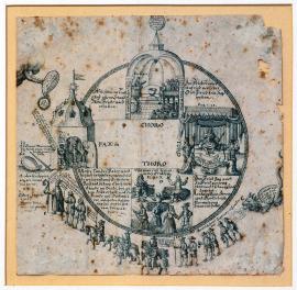
On
01.07.1648 (do 31.12.1648)The engraving pictures the scenes depicting a preacher in the church, a king on the throne with a baby at his feet, and a merry peasant harvest festival, arranged irregularly in a circle. To the left, there is a tower with a flag and an officer wearing a crown of thorns on his head and accompanied by two soldiers standing by the entrance to the tower. The officer says (in translation): “God be merciful with me! People want to torture me. They keep quarrelling and grieving me!” A hand with a shield and a wreath protrudes aside, with an inscription reading: “Do not worry! I am thy shield and great reward!” Beneath the hand a crowd of criminals and miscreants “in sheep's clothing” passes by, amongst them robbers, thieves, looters. Behind the crowd we can see a monster (the devil) blowing smoke. Besides that, there is a shield with a sword and an inscription beside reading: “precibus et armis”. Empty spaces in between the scenes are mostly filled with the quotes from biblical Psalms.
Signature: Not available
Autor: Hollar Václav z Práchně, český mědirytec
Original name: Pax in Choro, Toro, Thoro.
Katalogová čísla: Collection Český Šternberk, kód: 428/143
On the one hand, the leaflet highlights beneficial effects of peace to the lives of all social classes and estates (the monarch, the church and the folk), as opposed to the pernicious and destructive effects of war on the other hand. The author of the graphic work moralises radically both in image and word. Zíbrt attributes this graphic work to Wenceslaus Hollar and dates it to the year 1648. It is nevertheless uncertain whether our print is Hollar's original, a contemporary re-print or later imitation of Hollar's artwork.
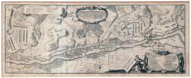
Dingolfing, On
16.07.1648 (do 13.08.1648)The engraving has a character of a map. Across the depicted territory flows the Isar river, with several military camps on both banks. In the top left part there is a decorative ribbon with caption 1-9, in the bottom right part there is a decorative baroque cartouche with caption A - Z. Rather extensive German explanatory text, which is quoted above, is located in centre of an oval cartouche in the top part of the engraving.
Signature: Per Cornelium van den Busch, General-Quartiermeister.
Autor: Dusch Cornelius van den, Generalquartiermeister, nizozemský kartograf
Original name: Der Allyrten Armeen Feldlager bei Dingelfing, und gegentheils Kaiserl. und Churbayrischen Armeen, bei dem Dorff Maming, das schwedische unterm Commando ihr Excell. Herrn Gen. Feldmarschallen Carl Gustav Wrangell, das französische unterm Commando der Herrn Gen. de Tourenne. Gegentheils das Kayserliche unterm Commando des Herrn Generalleutnants Piccolomini und Chur-Bayrische unter Commando des Herrn Feldmarschalls Enckefurth, das schwedische Lager angefangen den 16. July und auffgehoben den 18. August, das Kayserliche angefangen den 24. July und auffgehoben den 13. August Anno 1648.
Katalogová čísla: Collection Český Šternberk, kód: 402/303
After the Battle of Zusmarshausen in Bavaria on 7th May 1648, in which the imperial troops were defeated and their commander, Lieutenant General Holzappel-Melander, was fatally injured, the Swedish-French army led by Wrangel and Turenne temporarily settled in the basin of the Isar river near Moosburg and Dingelfing. The engraving depicts the situation in Moosburg, which is located approximately 40 km north-west of Munich in the direction of Lanshut. The imperial and Bavarian troops camped nearby, but were soon forced to retreat to the south-east, beyond the Inn. The Franco-Swedish allies had superiority and pursued the enemy as far as the Inn. The river level was nevertheless severely elevated due to heavy spring rains and the allies were forced to stop their victorious advance aimed at the heart of the Austrian hereditary lands after several unsuccessful attempts to cross the swollen Inn.
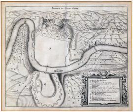
Praha, On
26.07.1648The schematic layout of Prague misses the separate city quarters and depicts vacant areas instead. The Vltava flows through the town. In the right bottom corner there is a square decorative cartouche with caption A-O, implying that the plan depicts Prague as it was before the siege by the Swedes in the summer of 1648. Below the top edge of copper engraving, there is the above mentioned brief inscription.
Signature: Not available
Autor: Unknown
Original name: Grundrisz der Prager Stätte.
Katalogová čísla: Collection Český Šternberk, kód: 400/379
The Swedes conquered the Prague Castle and the Lesser Town in July 1648 due to the betrayal of the expelled imperial governor Ottowaldský who disclosed an unguarded entrance to the Prague Castle defence system to the Swedish general Königsmark. In spite of the following big fuss amongst the Prague citizens, they were tenaciously defending the town under the command of General Colloredo until reinforcements arrived, led by Puchheim of Kladsko and Conti of Budejovice. In August, Königsmark stopped the besieging Prague and began to march to southern Bohemia against Puchheim, who could not stay in Prague due to lack of fodder for army horses. The Old Town stood up to the attempts of the Swedes to conquer it. The siege of Prague was later relaunched on October 5, 1648 by Carl Gustav, Prince of the Palatinate of the Rhine.
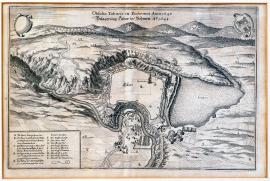
Tábor, On
13.08.1648In centre of the engraving there is a schematic representation of the town of Tábor; the only structures engraved by the artist in detail are the church and the fortification system around the city, the remaining parts are empty. In the right part of the engraving there is Jordan Pond, to the left, the Lužnice river runs through. In the background there are woody hills with Chotovinský church on top of one of them. In the right corner we can see an inclined representation of the coat of arms of the town of Tábor. On the left, there is an empty cartouche. In the bottom left corner there is a square box with caption: A-O.
Signature: Not available
Autor: Unknown
Original name: Obsidio Taboris in Bohemia Anno 1648. Belagerung Tabor in Böhmen Anno 1648.
Katalogová čísla: Collection Český Šternberk, kód: 403/323
In times of the Swedish siege of Prague under the command of Wittenberg and Königsmark, in summer of 1648, the imperial General Count Puchheim with a cavalry unit came to help the distressed town and its citizens. Since Prague still has not been completely besieged by the Swedes at the time, Puchheim managed to break into the Old Town. However, lack of fodder for the horses soon forced the cavalry unit to leave Prague through the Vysehrad gate, heading for southern Bohemia. As soon as Wittenberg found out about the retreat, he set to march to follow in Puchheim's footsteps and caught up with his troops nearby Hluboká. The imperial cavalry was defeated in the following clash and Puchheim was captured. Wittenberg afterwards looted and pillaged the whole area of South Bohemia. In August 1648 the Swedes advanced as far as Tábor, besieged the town, and their eight-day intensive shelling eventually made the town surrender. Wittenberg found a rich booty here, as many wealthy people from around had hidden their assets from the looting Swedes in this town with firm fortifications.
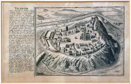
Tábor, On
13.08.1648Small view of the town of Tábor lying at a natural elevation; the Lužnice river is flowing behind the town. To the left, there is a description of the town from historical perspective. The engraving is a mature piece of art revealing fine taste of the author.
Signature: Gabriel Bodenehr excudit.)
Autor: Bodenehr G., mědirytec a kartograf
Original name: Thabor
Katalogová čísla: Collection Český Šternberk, kód: 404/459
In times of the Swedish siege of Prague under the command of Wittenberg and Königsmark, in summer of 1648, the imperial General Count Puchheim with a cavalry unit came to help the distressed town and its citizens. Since Prague still has not been completely besieged by the Swedes at the time, Puchheim managed to break into the Old Town. However, lack of fodder for the horses soon forced the cavalry unit to leave Prague through the Vysehrad gate, heading for southern Bohemia. As soon as Wittenberg found out about the retreat, he set to march to follow in Puchheim's footsteps and caught up with his troops nearby Hluboká. The imperial cavalry was defeated in the following clash and Puchheim was captured. Wittenberg afterwards looted and pillaged the whole area of South Bohemia. In August 1648 the Swedes advanced as far as Tabor, besieged the town, and their eight-day intensive shelling eventually made the town surrender. Wittenberg found a rich booty here, as many wealthy people from around had hidden their assets from the looting Swedes in this town with firm fortifications.
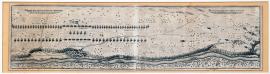
Landsberg, On
28.09.1648 (do 29.09.1648)The very wide and low engraving shows a long stretch of the Lech river and the elongate battle formations of the two armies. Beside the right edge of the drawing there is the town of Landsberg with canon firing. The entire depicted landscape is divided into rectangular fields and dotted with secluded trees with spherical treetops. On the right there is a German explanatory text, on the left there is the same inscription in Latin.
Signature: Carl Henric a Osten ingenieur delineavit.
Autor: Osten Carl Henricus, fortifikační inženýr
Original name: Abrisz und Andeutung, wie die allyrten Armeen als schwedische und französische den 28. und 29. September 1648 unweit von Landsbergk in Bataglia gestanden und ihr Gegentheil erwartet.
Katalogová čísla: Collection Český Šternberk, kód: 406/471
After the hurried retreat of the imperial-Bavarian troops commanded by Gronsfeld under the pressure by the allied (Swedish-French) units led by Wrangel and Turennových to the Lech, the Danube and eventually as far as to the Inn in May 1648, the situation turned in favour of the imperial and Bavarian troops once again. The allies could no longer get across the Inn swollen due to spring rains and in the meanwhile the imperial and Bavarian army received reinforcements from the units under the command of generals Piccolomini and Enkefort. Wrangel and Turenne found out that further progress eastward would be unthinkable and decided to retreat. When they arrived back to the Lech, the situation depicted in the picture occurred: charioteers fording their wagons across the river followed by the remaining combat units of the allied armies in the evening of the same day (30th September 1648). Right after crossing the Lech, Wrangel and Turenne kept retreating towards the north-west.
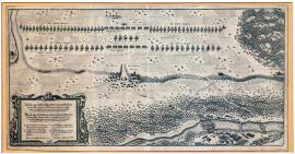
Scheuringen, On
30.09.1648The wide picture depicts position of the allied (Swedish-French) troops at the outskirts of Scheuringen; in the vicinity we can see Lichtenburg and Hallenberg castles. The foreground portrays a forest and the Lech river, only just being crossed by the charioteer troops of the allies. In the lower left corner of the picture there is a square decorative cartouche with German explanatory text and caption: A-D. The inscription is also given in Latin.
Signature: Corn. van dem Busch. Carl Henric. von Osten ing. delin.
Autor: Osten Carl Henricus, fortifikační inženýr
Original name: Abrisz und Andeutung, wie die schwedische und französische Arméen den 30. Septembris 1648 bey dem Dorf Scheuringen in Bataliglia gestanden, ihre Bagage über den Lech gehen lassen und gegen den Abend auch gefolget.
Katalogová čísla: Collection Český Šternberk, kód: 405/439
After the hurried retreat of the imperial-Bavarian troops commanded by Gronsfeld under the pressure by the allied (Swedish-French) units led by Wrangel and Turennových to the Lech, the Danube and eventually as far as to the Inn in May 1648, the situation turned in favour of the imperial and Bavarian troops once again. The allies could no longer get across the Inn swollen due to spring rains and in the meanwhile the imperial and Bavarian army received reinforcements from the units under the command of generals Piccolomini and Enkefort. Wrangel and Turenne found out that further progress eastward would be unthinkable and decided to retreat. When they arrived back to the Lech, the situation depicted in the picture occurred: charioteers fording their wagons across the river followed by the remaining combat units of the allied armies in the evening of the same day (30th September 1648). Right after crossing the Lech, Wrangel and Turenne kept retreating towards the north-west.
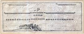
München, On
01.10.1648 (do 02.10.1648)The wide copper engraving depicts the town of Schwäbisch München beside its bottom edge, with elongate battle formations of the two armies in vicinity. In centre of the upper formation there are two firing cannons. The territory is divided – as customarily – into the square fields. On both the left and right upper sides there are explanatory texts in German and in Latin respectively.
Signature: Lept není signován, je však nesporně dílem Ostenovým, resp. Buschovým.
Autor: Unknown
Original name: Abriss und Andeutung, wie die schwedische und französische Arméen da sie über den Lech gegangen und Bayerlandt quitiert den 1. und 2. Octobria Anno 1648 bey dem Flecken Schwäbishen München in Bataglia gestanden und ihr Gegentheil erwartet.
Katalogová čísla: Collection Český Šternberk, kód: 407/449
After the campaign of Swedish and French troops to the south-east and across the Lech, the Danube and as far as to the Inn in May 1648, and after their retreat back across the Lech on 30th September 1648, Wrangel and Turenne's armies built defensive formations nearby the town of Schwäbisch-München on 1st and 2nd October, awaiting the arrival of the imperial-Bavarian troops advancing under the command of Piccolomini, Enkefort and Gronsfeld in their footsteps. The expected clash nevertheless did not break out, as the Swedish units of Wrangel's army withdrew to Ohrnbau upon the Altmühle river, and Turenne with the French troops retreated to Feuchtwangen. Imperial troops crossed the Danube nearby Ingolstadt to get through to the Upper Palatinate before the Swedes.
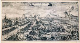
Praha, On
05.10.1648 (do 02.11.1648)The left half of the engraving depicts a part of Prague (unrecognisable which), being intensely attacked by the Swedes. The battle turmoil is going on and there is a range of various military scenes portrayed in much detail, as for instance location of cannons, first aid giving to the wounded soldiers right on the battlefield, cannonballs flying over the heads of the combatants, and the whole batteries of firing artillery depicted at the elevated spots. In the sky there is a decorative ribbon with a brief inscription. The overall composition as well as the individual masterfully crafted details reveal the author's high artistic qualities and mastery in copper engraving at a glance.
Signature: Not available
Autor: Screta Carlo, český malíř
Original name: Bestürmbung der Prager Stätte 1648.
Katalogová čísla: Collection Český Šternberk, kód: 411/468
After having withdrawn from Prague on 15th August 1648, Wittenberg pursued the imperial cavalry under the command of general Puchheim and defeated it nearby Hluboká. In the meanwhile, the commanding generals Conti and Colloredo strengthened defensive capacity of Prague awaiting further siege. Various measures to repulse the enemy were adopted: the students as well as monastic monks were armed, city walls were repaired and the defenders even made hand grenades. On 5th October, Carl Gustav, the Prince of the Palatinate of the Rhine, Duke of Bavaria, with his army came to Prague and, at the same time, Wittenberg with his unit returned from their excursion about the south-west Bohemia, which they dealt with mostly as outrageous looting amongst the civilians. An extremely intensive siege of Prague followed afterwards, which nevertheless did not lead to the conquest of the city and resulted in significant losses at the Swedish side (about 800 men died), mainly thanks to the heroic resistance of tenacious defenders (soldiers, burghers and students ).The Prince of the Palatinate of the Rhine at first asked for a short-term truce to be able to bury the fallen. However, when he found out about the imperial army coming to Prague to help the citizens, he decided to terminate the siege on 2nd November 1648. The fallen amongst Prague defenders included: 13 students, 2 priests, 103 burghers and 101 soldiers – 219 victims in total. 475 men were wounded. The losses of conquerors were several times higher.
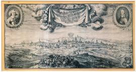
Praha, On
05.10.1648 (do 02.11.1648)A view of the city from the east; in the foreground there are several artillery batteries firing at the city. In the background we can see the Prague Castle panorama and an outline of the Hunger Wall. Lesser Town of Prague is shrouded in thick smoke due to fire. In central part of the sky there is a sort of a drapery with two female figures. One is carrying a stark, holding a small sphere in one of its legs; the other is holding a shield with an inscription: To the left, there is a portrait of General Rudolf Colloredo, to the right, a portrait of Innocent Conti, both in ovals decorated with laurel and palm sprays. They both were imperial generals defending Prague against the Swedes. The overall composition of the picture as well as its details show the excellence and mastery of both the author (Škréta) and the engraver (Merian) at a glance.
Signature: Carlo Screta delineavit. M. Merian excudit.
Autor: Screta Carlo, český malíř
Original name: Wahrer Abriss beyder königlichen Haubt Alt und Neustatt Prag wie dieselben von dess königl. Schwedischen Generalissimi fürstl. Durchlaucht Herrn Herrn Carl Gustavo Pfalzgraffen bey Rhein Hertzogen in Bayern, den 5. Octobris belägert mit Approci, Minen, Canonieren und Stürmben stark bedrängt und dann den 2. Novembris 1648 wiederumm verlassen und quittiert worden.
Katalogová čísla: Collection Český Šternberk, kód: 412/465
After having withdrawn from Prague on 15th August 1648, Wittenberg pursued the imperial cavalry under the command of general Puchheim and defeated it nearby Hluboká. In the meanwhile, the commanding generals Conti and Colloredo strengthened defensive capacity of Prague awaiting further siege. Various measures to repulse the enemy were adopted: the students as well as monastic monks were armed, city walls were repaired and the defenders even made hand grenades. On 5th October, Carl Gustav, the Prince of the Palatinate of the Rhine, Duke of Bavaria, with his army came to Prague and, at the same time, Wittenberg with his unit returned from their excursion about the south-west Bohemia, which they dealt with mostly as outrageous looting amongst the civilians. An extremely intensive siege of Prague followed afterwards, which nevertheless did not lead to the conquest of the city and resulted in significant losses at the Swedish side (about 800 men died), mainly thanks to the heroic resistance of tenacious defenders (soldiers, burghers and students ).The Prince of the Palatinate of the Rhine at first asked for a short-term truce to be able to bury the fallen. However, when he found out about the imperial army coming to Prague to help the citizens, he decided to terminate the siege on 2nd November 1648. The fallen amongst Prague defenders included: 13 students, 2 priests, 103 burghers and 101 soldiers – 219 victims in total. 475 men were wounded. The losses of conquerors were several times higher.
Münster, On
14.10.1648This circular picture is set into a square and depicts an allegory of peace. A crowned woman adorned with the Imperial Eagle coat of arms is sitting on top of a hill, representing the most likely 'Germania'. The second female figure, certainly personifying peace, is standing on a cloud, holding a laurel branch in her left hand and stretching out her right hand to Germania. In the sky there are two angels blowing trumpets and holding flags with the inscription 'Peace'. This group of figures is surrounded by kneeling and praying persons. In the four corners of the engraving there are decorative cartouches with allegorical depictions of faith, wealth, diligence and fame. Above the depiction itself, there is the text quoted above, the year 1648 and a Latin verse. Under the depiction there is a German poem with the theme of peace, urging to thanksgiving for peace to our Lord. The text of the Psalm No. 147 praising the Lord is surrounding the picture, accompanied by a dedication “Domino Josepho Furtenbach...”
Signature: Not available
Autor: Arnold Jon., mědirytec
Original name: Sinn-Bild über den im Jahr 1648, den 14. Tag des Winmons zu Münster getroffen und beschlossenen allgemeinen Reichsfrieden.
Katalogová čísla: Collection Český Šternberk, kód: 408/121
The engraving expresses the joy and satisfaction of German people suffering from hardship for the past thirty years, for the conclusion of the Peace of Westphalia in Münster on October 14, 1648.
On
24.10.1648The picture portrays a crowned female figure holding a standard with the picture of a wreath in her right hand and a palm branch in her left hand. The figure is a symbol of peace. She is standing on a killed soldier to illustrate the end of the war and re-established peace. In the left part of the picture there are lots of arms scattered around, such as rifles, pikes, cannon barrels, drums, battle standards, a helmet shot through, a powder keg, etc. In the background there is a military wagon with harnessed horses, military units and armed individuals. On the hilltop we can see the building of a castle. On the top left side there is a depiction of the Lord standing in a cloud, who is illuminating an allegorical figure of peace with a beam of light. He is holding the Orb in his right hand. On both sides of the picture we can read an extensive German poem with the theme of peace. Furthermore, there are quotations of a number of psalms that could be associated with the theme of peace.
Signature: Allen Christlichen & friedliebenden Hertzen dediciert & überschrieben durch Mathaeum Rembolden Kupferstechern und Kunsthändlern in Ulm 1648.
Autor: Rembold Mathtius, rytec a obchodník s uměleckými předměty v Ulmu
Original name: Est ist Fried, Psalm 46. v 6. 7. Kommet her und schawet die Werck des Herrn, der auff Erden solch Zerstören anrichtet, der den Kriegen stewert in aller Welt, der Bogen zerbricht, Spiesz zerschlägt und Wägen mit Fewer verbrennt.
Katalogová čísla: Collection Český Šternberk, kód: 409/119
The leaflet is dealing in details with the end of the Thirty Years' War, both visually and verbally, from the religious perspective. It aptly expresses mentality of people of the 17th century, who had lived through three decades of suffering and hardship in one of the fiercest wars in the history.
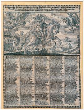
Münster, On
24.10.1648 (do 25.10.1648)The engraving depicts a post messenger on the horseback, blowing a small trumpet. In the sky on the right we can see Mercury, conveying a message of peace, and on the left we can see the goddess Pheme blowing a long trumpet adorned with a flag with the Imperial Eagle. On the left there are two men coming out of a house; in the background there are castle ruins, the sea with a boat and a hinted structure of a bridge with a man walking there across with a cane. German explanatory text is written above the main image of the work. In the bottom part of the picture there is an extensive poem explaining beneficial effect of peace in all situations of life and ending with an appeal to the mankind to live Christian lives and to show humility in the way deserving the mercy of permanent peace.
Signature: Bey Marx Antho. Hannas.
Autor: Hannas Marx Anthon, rytec a nakladatel v Augsburgu
Original name: Freudenreicher Postilion von Münster, den durch des allerhöchsten ohnaussprechliche Gnad, von den vernehmbsten Potentaten der ganzen Christenheit, daselbst den 24. und 25. Oktober Anno 1648. Ratificiererten, underschriebenen und mit grossen Frewden offentlich Publicierten hochwerthen lieben Frieden bringent.
Katalogová čísla: Collection Český Šternberk, kód: 410/125
This political leaflet allegorically depicts declaration of the Peace of Westphalia concluded in Münster on 24th and 25th October 1648. The goddess Pheme, i.e. the figure on the left side of the sky, is spreading the joyful news of the peace agreement, and Mercury represents prosperity, which is about to get gradually established after the Thirty Years' War finally ended. The castle ruins symbolize destruction and economic damage caused by the war; the men coming out of the house represent civil life of men who had returned from the war. The poem is dealing comprehensively and in depth with the overall situation in Germany after the peace making, and is ending with a plea to the Lord to preserve the peace for good.
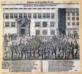
On
25.09.1649The engraving depicts a town square with a large building featuring a stone portal and a wide window next to it. A huge figure of the Swedish Lion is in the window with two flows of red wine and white wine respectively running from his mouth. In the foreground there is a large crowd of people celebrating peace. A German explanatory text in verses underneath explains the depicted scene. Drugulina suggests the text was written by J. Klay.
Signature: J. Klay
Autor: Klay J., básník
Original name: Abbildung des schwedischen Löwens, welcher den 25. des Herbstmonats dieses lauffenden Jahrs bey Ihrer hochfürstlichen Durchlaucht des Herrn Generalissimi Friedenmal rothen und weissen Wein in 6 Stunden häuffig aus dem Rachen flieswn lassen.
Katalogová čísla: Collection Český Šternberk, kód: 429/436
Once the Thirty Years' War finally ended, large public peace celebrations, such as fireworks, feasts, folk festivities, etc. took place everywhere. This graphic work does not indicate, where exactly the Swedish Lion “organized” the drinking bout, however, certain circumstances suggest that the feast took place in Nuremberg.
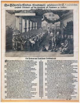
Nürnberg, On
25.09.1649The graphic work depicts a big feast. Above the long table crowded with boarders there is a canopy, an instrumental and a vocal group respectively play and sing at sides. To the right we can see a painter (J. of Sandrat) portraying the whole festive scene. The master of ceremonies is standing nearby. In the background there is a big picture of the Swedish Lion, accompanied atop with an extensive German poem praising peace and condemning war with even relatively rude expressions.
Signature: Not available
Autor: Sandrat, německý malíř
Original name: Das Schwedische Friedens-Freudenmahl gehalten von des Generalissimi Hochfürstl. Durchlaucht auf dem Gerichtsaale des Rathauses zu Nürnberg, den 25. Heumonds 1649.
Katalogová čísla: Collection Český Šternberk, kód: 430/384
As soon as the representatives of the countries at war ratified the terms of peace in Münster on 14th October 1648 (the Peace of Westphalia), great celebrations of various kinds (feasts, fireworks, parties, etc.) were held everywhere to express the happiness of people about the end of the Thirty Years' War. The depicted celebration of the war end and peace was held on 25th September 1649 in Nuremberg by Carl Gustav, the Prince of the Palatinate of the Rhine, one of Sweden's leading generals from the last years of the war, he who was besieging the city of Prague in summer of 1648. This feast was portrayed several times. It is quite extraordinary that there is a big sitting dog depicted in front of the guests present in the dining hall.
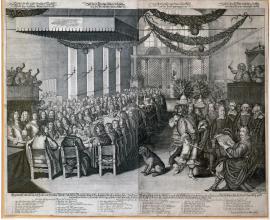
Nürnberg, On
25.09.1649In the left part of this large picture of a feast there is a long table crowded with boarders and with a canopy above it. Both instrumental and vocal groups of musicians stand at both sides of the table. In the foreground to the right we can see the painter Sandrat portraying the whole festive scene and the master of ceremonies standing by his side. Garlands and sprays are hanging from the ceiling. Four German verses read above the image. The caption naming all the participants at the banquet is situated in the bottom part of the picture, together with the German text quoted above.
Signature: Wolfgang Kilian sculpsit. – Nürnberg bey Jeremia Dümlern.
Autor: Sandrat, německý malíř
Original name: Eygentliche Abbildung des Fried- und Freuden-mahls, welches der durchlauchtigste, hochgeborene Fürst und Herr herr Carol Gustav Pfaltzgraw bey Rhein etc. nach Abhandlung der Preliminartractaten in des heiligen Reichs Statt Nürnberg auf dem Rathaussaal den 25. September 1649 gehalten.
Katalogová čísla: Collection Český Šternberk, kód: 431/474
As soon as the representatives of the countries at war ratified the terms of peace in Münster on 14th October 1648 (the Peace of Westphalia), great celebrations of various kinds (feasts, fireworks, parties, etc.) were held everywhere to express the happiness of people about the end of the Thirty Years' War. The depicted celebration of the war end and peace was held on 25th September 1649 in Nuremberg by Carl Gustav, the Prince of the Palatinate of the Rhine, one of Sweden's leading generals from the last years of the war, he who was besieging the city of Prague in summer of 1648. This feast was portrayed several times. It is quite extraordinary that there is a big sitting dog depicted in front of the guests present in the dining hall.
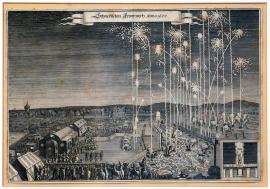
On
01.01.1650 (do 31.12.1650)The print depicts festive fireworks. On the right we can see several fired rockets rising into the air. In the foreground there is a group of spectators and a carriage. On the left there are scattered tents and pavilions, with several watching dignitaries in front. In the background we can see a city with a tower of a remarkable shape, resembling so called water tower. In the bottom to the right there is a separate square field depicting a figure standing with a stick on five pillars in front of a cloud of smoke. Above the figure read the letters “C R” with a crown, while the inscription “CGP vivat” is written at the figure's feet.
Signature: Not available
Autor: Unknown
Original name: Schwedisches Feuerwerks Anno 1650.
Katalogová čísla: Collection Český Šternberk, kód: 439/169
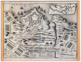
Porto Longo, On
01.01.1650 (do 31.12.1650)The engraving depicts an outline of the situation in the port of Porto Longo in the island of Elba. The town with a fortress is portrayed along the top border of the depicted territory. The town centre is left empty, drawings free, the buildings within the fortification system are nevertheless drawn in detail. Several ships are navigating in the sea. In the right corner there is a wide ribbon with the map of of Elba island. In the bottom there is another ribbon with a German inscription and caption: A-R.
Signature: Not available
Autor: Unknown
Original name: Obsidio castri Porto Longo in Insula Elba. Belägerung der Vestung Porto-Longone in der Insul Elba 1650.
Katalogová čísla: Collection Český Šternberk, kód: 441/100
Once the Peace of Westphalia was ratified in 1648, the war amongst the major adversaries, i.e. Holy Roman Empire, Sweden, France and the armies of several German electors, finally ended up, but the fights between Spain and France kept going on, including the French siege of the port and fortress of Porto-Longo occupied by the Spanish on the island of Elba, facing western coast of Italy in 1650.
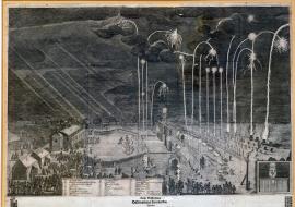
Nürnberg, On
04.06.1650This large-sized work is depicting in detail fireworks. On the left there are several pavilions with spectators, while the fireworks are fired from several rows at the opposite side. The engraving depicts the rising rockets as white and ramifying luminous columns against the dark background. In centre of the image we can see a gate with a figure, which is also portrayed in detail in a separate field in the right bottom part. Under the image, nearly in the centre, there is an explanatory caption: A-Z. Below the caption reads an extensive German rhymed text recounting succession of events during the ceremonial launching using the caption.
Signature: Werkstellig gemacht durch Johann Carl Zeuchmeister und Ingenieur etc.
Autor: Sohlippenbach Christoph Carl, dvorní maršálek
Original name: Kurtze Beschreibung desz künstlichen Feuerwerkes, welches dem durchlauchtigsten hochgeborenen Fürsten Carl Gustaven Pfaltzgraven bey Rhein, in Beyern, zu Gülch, Cleve und Berg Hertzogen, Graven zu Ildentz Spanheim der Mark und Ravensburg, Herrn zu Ravenstein etc. Zu unterthänigen plichtschuldigsten Ehren verbrennet… Christoph Carl von Schlippenbach, dero hochfürstl. Durchlaucht wolverordneter Hofmarschalk.
Katalogová čísla: Collection Český Šternberk, kód: 432/348
The end of the devastating Thirty Years' War was celebrated a long time after the conclusion of the Peace of Westphalia at various places but mainly in Nuremberg. Various folk feasts, banquets and massive fireworks were held to express the happiness of people about the end of one of the fiercest wars in the history. These celebrations of peace were a welcomed theme for many painters and engravers, which is why we can see them in rather large number of graphic works. The fireworks in this engraving were launched in Nuremberg in honour of the Swedish Commander Carl Gustav, the Prince of the Palatinate of the Rhine.
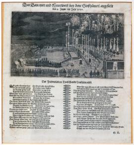
Nürnberg, On
04.06.1650Under the image reads an extensive German poem describing ceremonial launching of fireworks and emphasizing precious value of peace. Drugulin suggests the poem was written by S. V. Birken.
Signature: Not available
Autor: Birken s. v., básník
Original name: Das Banquet und Feuerwerk bey den Bleiszhämerl angestellt den 4. Juni im Jahr 1650.
Katalogová čísla: Collection Český Šternberk, kód: 433/367
The end of the devastating Thirty Years' War was celebrated a long time after the conclusion of the Peace of Westphalia at various places but mainly in Nuremberg. Various folk feasts, banquets and massive fireworks were held to express the happiness of people about the end of one of the fiercest wars in the history. These celebrations of peace became a welcomed theme for many painters and engravers, which is why we can see them in rather large number of graphic works. The fireworks in this engraving were launched in Nuremberg in honour of the Swedish Commander Carl Gustav, the Prince of the Palatinate of the Rhine.
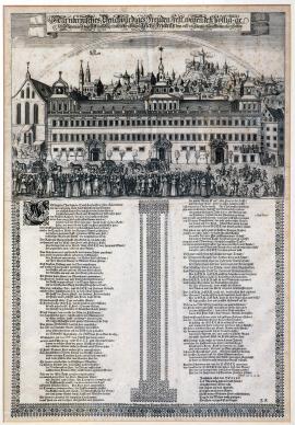
Nürnberg, On
26.06.1650The image depicts the city of Nuremberg; in the foreground we can see the town hall, with departing ambassadors. In the background there is a castle and a tower with a large star. A rainbow spans across the sky with a dove of peace flying therein, carrying a spray in its beak. The quoted (and translated) German inscription is placed above the image, while in the bottom part there is a two-stanza German hymn, according to Drugulin written by J. Klay. Drugulin attributes the work to L. Herberlein and to A. Kohl as the engraver.
Signature: Zu finden in Nürnberg bei Paulus Fürsten Kunsthändlern etc.
Autor: Kohl A., mědirytec
Original name: Nürnbergisches Denkwürdiges Freudenfest wegen desz völlig geschlossenen und daselbst einheltig unterschriebenen Reichsfriedens den 26. / 16. Juny jetzt lauffenden 1650 Jahrs.
Katalogová čísla: Collection Český Šternberk, kód: 435/99
During the summer of 1650 there were several peace celebrations with feasts, fireworks and folk gatherings organized in Nuremberg. These festivities were mainly organized by the the Swedish General of the last war years Carl Gustav, the Prince of the Palatinate of the Rhine, and the imperial General Octavio Piccolomini, Duke of Amalfi. The terms of peace adopted by the warring parties in Münster on 24th October 1648 already (the Peace of Westphalia), were later re-discussed several times and solemnly ratified once again at various conferences. These conferences usually concluded with public celebrations. So was the case of the Nuremberg conference in June 1650. The theme of this graphic work refers to its celebration. Several figures in the foreground of the print recall truthfully the Brueghel style of Dutch painters.
Nürnberg, On
26.06.1650The engraving depicts a peace conference. In the centre of a spacious hall we can see a table with eight dignitaries sitting and debating around. The apparently less important conference participants, presumably expert advisers of the main ambassadors, are standing along the walls. A stove in the Renaissance style is standing to the left and a stained glass window composed of small slides can be seen in the background. Further five debating participants of the conference are sitting on chairs in the foreground. Below the image there is a brief explanatory inscription and a few verses by J. Klay, praising the benefits of peace.
Signature: Johann Klay gekr. poet. L. Heberlein delineavit. A. Kohl excudit. P. Fürst scudit.
Autor: Kohl A., mědirytec
Original name: Abbildung der bey völlig geschlossenen Friedens-unterschreibung gehaltenen Session in Nürnberg den 26. 16. Juny 1650.
Katalogová čísla: Collection Český Šternberk, kód: 436/477
During the summer of 1650 there were several peace celebrations with feasts, fireworks and folk gatherings organized in Nuremberg. These festivities were mainly organized by the the Swedish General of the last war years Carl Gustav, the Prince of the Palatinate of the Rhine, and the imperial General Octavio Piccolomini, Duke of Amalfi. The terms of peace adopted by the warring parties in Münster on 24th October 1648 already (the Peace of Westphalia), were later re-discussed several times and solemnly ratified once again at various conferences. These conferences usually concluded with public celebrations. So was the case of the Nuremberg conference in June 1650. The theme of this graphic work refers to its celebration. Several figures in the foreground of the print recall truthfully the Brueghel style of Dutch painters.
Nürnberg, On
04.07.1650On the right side of the engraving there is a depiction of fireworks in front of a large pavilion, to the left there is a column with a statue allegorising peace. Several people are fencing nearby. The moon is shining from the sky on the left. Above the image reads a brief inscription in German (quoted above). A poem of twelve stanzas depicts the celebration on the one hand and highlights the beneficial effects of peace on the other hand.
Signature: Sigismund Betulius.
Autor: Betulius Zikmund, básník
Original name: Das Kayserliche Friedens-Freudenmahl gehalten von des Herrn Duca d´Amalfi Fürstl. Gnaden bey Nürnberg auf S. Johannes Schiessplatz den 24. / 4. Heumonds J. J. 1650.
Katalogová čísla: Collection Český Šternberk, kód: 434/462
The end of the Thirty Years' War and the Treaty of Westphalia were not celebrated only by the Swedes but also by the folks of the Holy Roman Empire. General Octavio Piccolomini, Duke of Amalfi, held a great celebration of peace on behalf of the Emperor depicted in the copper engraving in Nuremberg on 24th June 1650.
Nürnberg, On
14.07.1650The art work depicts a spacious area with two facing buildings - the Temple of Peace and the Fortress of Unrest. In the background we can see typical landscape of the Nuremberg region with its forests, meadows and fields. A brief explanatory inscription reads in a decorative ribbon located above the depiction, while in the bottom part of the image we can read an extensive German poem celebrating peace and condemning war.
Signature: Not available
Autor: Unknown
Original name: Tempel des Friedens und gegenüber gesetztes Castel des Unfriedens, wie solche bey Ihr. Fürstl. Gnaden Duca de Aamalfi zu Nürnberg gehaltenen Friedensmahle beim hellen Tage anzusehen gewesen.
Katalogová čísla: Collection Český Šternberk, kód: 437/268
The terms of peace adopted by the warring parties in Münster-Osnabrück on 24th October 1648 already (the Peace of Westphalia), were later re-discussed several times and solemnly ratified once again at various conferences. These conferences usually concluded with public celebrations. So was the case of the Nuremberg conference in June 1650. These festivities were mainly organized by Carl Gustav, the Prince of the Palatinate of the Rhine, the Swedish General of the last war years (who besides other things severely afflicted Prague in autumn of 1648), and the Emperor's representative, General Octavio Piccolomini, Duke of Amalfi. These celebrations of peace became a welcomed theme for many painters and engravers, certainly because they promised satisfactory sale as “souvenir pictures” amongst the audience. This is also why a large number of such themed graphic works have survived to date.
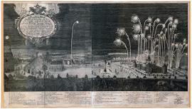
Nürnberg, On
14.07.1650The fireworks are portrayed over the large space of the graphic work. The rising rockets are depicted as white and ramifying luminous columns against the dark background. This impressive way of the fireworks depiction was applied by all authors of the engravings with the same theme. A mansion house with several pavilions on the right side of the picture is facing an allegorical statue representing peace with several other buildings on the left. Many spectators are standing in the foreground. An oval cartouche with German explanatory text and the Imperial Eagle are located in the top left corner and the comprehensive caption: A-Z and a-g in the bottom part of the print.
Signature: Nürnberg bey Jeremia Dümmlern zu finden. Michael Herz delineavit. Peter Troschel sculpsit.
Autor: Troschel Peter, mědirytec
Original name: Eignelticher Abrisz desz Feuerwerks-Schlosses und der Baraquen, in welcher ausz Röm. Kay. May. allergnädigsten Begehlch dem königlich schwedischen Generalissimo Herrn Pfaltzgraffen Carl Gustaven etc. Churfürsten und Ständt anwesenden Herren Gesanden auch fürstlichen Persohnen & Frauen-Zimmer vom Herrn Generalleutnant Duca d´Amalfi dasz Fried und Freudenmahl nechst bey Nürnberg auff Sanct. Johannes Schieszplatz den 14. July anno 1650 gehalten ward.
Katalogová čísla: Collection Český Šternberk, kód: 438/470
The terms of peace adopted by the warring parties in Münster-Osnabrück on 24th October 1648 already (the Peace of Westphalia), were later re-discussed several times and solemnly ratified once again at various conferences. These conferences usually concluded with public celebrations. So was the case of the Nuremberg conference in June 1650. These festivities were mainly organized by Carl Gustav, the Prince of the Palatinate of the Rhine, the Swedish General of the last war years (who besides other things severely afflicted Prague in autumn of 1648), and the Emperor's representative, General Octavio Piccolomini, Duke of Amalfi. These celebrations of peace became a welcomed theme for many painters and engravers, certainly because they promised satisfactory sale as “souvenir pictures” amongst the audience. This is also why a large number of such themed graphic works have survived to date.
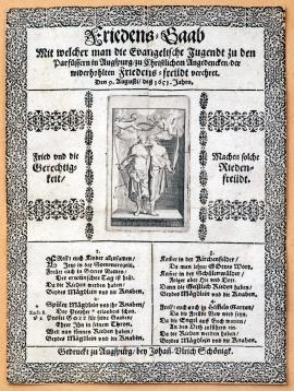
Augsburg, On
09.08.1651The print depicts two figures symbolizing justice and peace. Justice is holding scales and sword, Peace is carrying a palm spray. Two angels with laurel wreaths are hovering above them. The picture is bordered along both sides with German texts relating to the depicted figures. Under the picture we can read a four-stanza German poem, urging the youth to celebrate peace and condemning war with all its horrors.
Signature: Gedruckt zu Augspurg bey Johasi Ulrich Schönigk.
Autor: Schönigk Johann Ulrich, tiskař v Augsburgu
Original name: Friedens-Gaab, mit welcher man die evangelische Jugendt zu den Parfüssern in Augspurg, zu christlichen Andenken der wiederhohlten Friedensfreudt verehret. Den 9. Augusti 1651 Jahre.
Katalogová čísla: Collection Český Šternberk, kód: 440/157
The picture is the most likely a souvenir image from a peace celebration designed for the youth, held in Augsburg on 9th August 1651.
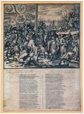
On
01.01.1674 (do 31.12.1674)The engraving depicts a large group of figures, some wearing big hats with feathers. They are the Emperor with his company and William III of Orange taken by hand by the representatives of the Netherlands and Seeland. Young William III, recently appointed into a prominent position by a popular uprising, is vainly persuaded by two dignitaries to take the side of the French-English alliance once again and to rejected the Spanish-imperial alliance. In the foreground we can see some priests, a treasure chest with money, books, etc. In the background to the right there is a group of people standing in front of the harbour full of ships and a cannon. On the left side of the image there is a space with medallions and small pictures of towns. The heads of unknown savages impaled on spears are depicted therein too. An extensive German text is written in the bottom part of the image.
Signature: Not available
Autor: Unknown
Original name: Wie boven zynen staet, verwaent zich durf verhaffen, En steeken everd was den Hemel naar zyn Kroon.
Katalogová čísla: Collection Český Šternberk, kód: 442/64
The history of the Netherlands during the second half of the 17th century was rather complicated. Louis XIV was fighting intensively with the Netherlands in an attempt to seize Flanders. Even England was earlier in the beginning standing in the camp of the Dutch enemies. Later on, the Estates-General of the United Netherlands succeeded in gaining, Sweden and England as allies and in forcing Louis XIV into the Peace of Aix-la-Chapelle (Aachen). In 1672, however, the war with France broke out again. The Dutch demolished the embankments separating the Dutch depressions from the sea, and thus prevented the French from invasion. The popular uprising appointed William III of Orange the Governor and Captain General of the country. He managed to establish an alliance with the Holy Roman Empire and Spain, and to expel the French enemy out of the country with the help of the allies. The Treaties of Nijmegen establishing peace were signed in 1678.