Engravings of the year 1629


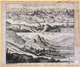
The actual illustration of the pass between Steig and Chur in Pünten, seized by Imperial forces in 1629.
The sheet is divided into two pictorial parts; the lower part depicts the small town of Chur on the Rhine in western Switzerland, and the upper part shows the Rhine countryside with high mountains, the Rhine and a bridge. In the countryside there is a large number of small settlements, castles, fortresses etc.
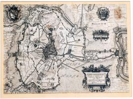
A true and actual drawing of the great and very well-known siege of the fortified town of Herzogenbusch, with everything divided according to the correct scale.
This is a very accurate, mapped situation of the environs of the town of Herzogenbusch in the north of the Brabant province in the Netherlands. On the right is the river Meuse. The wide surroundings of the town are filled with an extensive system of bulwarks and field fortifications. Above the picture there are two emblems. On the right, near a bend in the Mosel, there are two cartouches decorated with weapons, with the inscription: “Rheinländische Rutten“. Another cartouche contains the above-mentioned text. There is a measuring scale nearby.