Engravings of the year 1627


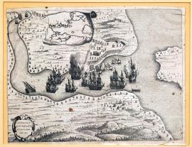
Looting of sugar in the harbour of de Tode los Santos, 1627.
The etching depicts the harbour of Todos los Santos on the Atlantic coast of Brazil, near San Salvador (Bahia), approximately 1,400 km north of Rio de Janeiro. In the harbour there are several battleships with sails, of which two are in flames. The coast is fortified and occupied by battling troops. On the sea there are several smaller boats without sails, occupied by shooters who are firing at defensive positions on the coast. Above the picture there is an unfolded vignette with a clear map of the situation. At the bottom on the left there is a round, decorative cartouche with the above-quoted text. The engraver, in an effort to capture the tropical South American landscape, brightened up its character with many palm trees.
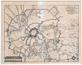
Grolla (was) besieged and conquered by His Highness Prince Frederick of Orange, Count of Nassau, (during his) high command of the General United States of Belgium.
This is a map of the town of Grolla in the Netherlands, which is surrounded by various fortification buildings and military camps. The above-quoted Latin text is shown in the top right-hand corner. Below the picture, there is a measuring scale.
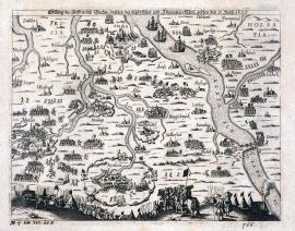
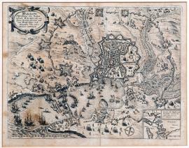
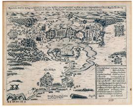
An illustration of the clash near Bleckede, which took place between Imperial and Danish troops on the 13th of June 1627.
The engraving depicts the countryside at the lower reaches of the Elbe and the Weser and Ems river basin. There are several towns depicted here, e.g. Hamburg, Bremen, Nordheim, Braunschweig etc. Troops are scattered throughout the entire area. On the right by the bridge is the town of Bleckede, where the main clash which is the subject of the picture took place. In the foreground are tents, several trumpeters and a woman with a pack basket.
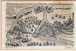
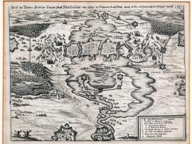
A depiction of Havelberg town and church, which were abandoned by the Danes and occupied by Imperial forces. 1627.
The picture depicts the area through which the Havel and Elbe rivers flow. On an island on the Havel river there is the town of Havelberg, and nearby there is Thumbhof, which means “a fortified hill with a church” (Thumb.Dom.). Downstream on the Havel river there are two forts facing each other, and between them an artillery barrage is shown. The Danes are just retreating from the fortress on the right. On the left, on the right bank of the Elbe, is the Imperial camp. In the left bottom corner of the print, a part of the town of Tangermünd is illustrated. At the top on the left-hand side is the legend A-E.
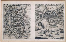
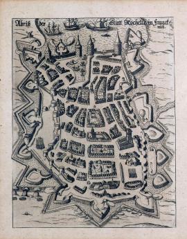
A drawing of the town of Rochelle in France.
On the height format, the town and fort of La Rochelle is depicted (the capital of the French department of Charente-Inferieure). At the top of the print, there is a harbour and three anchoring ships. Lower down, there is a town surrounded by ramparts and towers. The above inscription is in the image part of the print.
A true representation of the fortified town of Rochelle, with its fortifications, royal camps and field fortifications. 1627.
The town of La Rochelle is depicted from a so-called bird's eye view, with a harbour in which many ships are anchored. Around the town there are various military scenes, camps and field fortifications. In the bottom on the right there is a small map of the town environs. The quoted text is in a decorative cartouche in the top part of the picture.
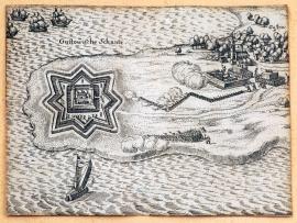
The Gustavian field fortification
On the peninsula there is a fortress whose floor plan consists of a star with a building in the middle. On the sea around the peninsula, five ships are sailing. On the dry land there is the small town of Gustow, protected by a field fortification. Troops are attacking the stronghold.
The actual drawing of the Brunswick fort and the princely residence town of Wolfenbüttel, which Mr. Gottfreid Heinrich, Reich Marshal, Lord of Pappenheim etc. clamped, sunk and, on the 24th of December 1627, conquered.
In the middle of the picture, there is the town of Wolfenbüttel, lying on the water. On both sides there are battling troops. Around the town there are several swamps and attackers' field fortifications, and at the bottom on the left there are two windmills. At the bottom on the right there is a square with the legend 1-22, and nearby there is a profile of a water dam.
A drawing of the fortified princely town of Wolffenbüttel which was besieged by the Count of Pappenheim in the name of His Imperial Majesty in 1627.
The etching depicts the town of Wolffenbüttel, surrounded by marshes. On both sides of the town there are battle skirmishes and gunshots from rifles. Small forests have been drawn in three places; several gallows have been built near one of them. Above the picture there is the above-quoted text; at the bottom there is a rectangle with the legend 1-12.